Low Pressure in the NW Caribbean/SE GOM: 1006mb
Moderator: S2k Moderators
Forum rules

The posts in this forum are NOT official forecasts and should not be used as such. They are just the opinion of the poster and may or may not be backed by sound meteorological data. They are NOT endorsed by any professional institution or STORM2K. For official information, please refer to products from the National Hurricane Center and National Weather Service.
-
Matt-hurricanewatcher

Looks like the NHC beleives it will head into the Gulf of Honduras:
SYNOPSIS FOR CARIBBEAN SEA AND TROPICAL N ATLC FROM 7N TO 22N
BETWEEN 55W AND 65W
.SYNOPSIS...BROAD TROUGH OVER THE W CARIBBEAN WITH ASSOCIATED
WEAK LOW PRES NEAR 12N80W 1010 MB WILL REMAIN NEARLY STATIONARY
THROUGH SUN NIGHT...THEN DRIFT SLOWLY WNW MON THROUGH THU. HIGH
PRES OVER THE CENTRAL ATLC WILL SHIFT N OF THE AREA THROUGH
SUN...THEN BE REPLACED BY A RIDGE EXTENDING SW TO THE NE
CARIBBEAN THROUGH MON. RIDGE THEN RETREATS E TUE THROUGH THU.
SYNOPSIS FOR THE SW N ATLC INCLUDING THE BAHAMAS
.SYNOPSIS...WEAKENING COLD FRONT FROM 31N67W TO THE CENTRAL
BAHAMAS AND SW TO W CENTRAL CUBA WILL REACH FROM 31N65W TO SE
BAHAMAS SUN MORNING...THEN BECOME DIFFUSE JUST E OF THE AREA
MON NIGHT. HIGH PRES BUILDING FROM W TO E ALONG 30N WILL
MAINTAIN LIGHT TO MODERATE E WINDS WINDS OVER MUCH OF THE AREA
SUN THROUGH TUE. STRONGER HIGH PRES WILL BUILD S INTO THE AREA
AND COMBINE WITH LOW PRES OVER THE NW CARIBBEAN SEA TO FURTHER
ENHANCE THE ELY WINDS.
I love this loop:
http://hadar.cira.colostate.edu/ramsdis ... at1_0.html
0 likes
-
Tampa Bay Hurricane

- Category 5

- Posts: 5597
- Age: 38
- Joined: Fri Jul 22, 2005 7:54 pm
- Location: St. Petersburg, FL
-
Matt-hurricanewatcher
Shear north of 15 north is very strong, around 30-40 knots. But below 12 north it is below 15 knots,,,also a upper level anticyclone appears to have formed over the southwestern Part of the western Caribbean near 11 north. Overall I would say that the weak "low pressure area" that appears to be at 16/83 is more or less a elongated north end of a trough/low level cirulation that is reforcusing around 13 north/82 west, or around the area of main convection. Do I think there is a closed LLC yet, not yet. But if things where to become more favorable with more convection and time. It would not suprize me. Models shows slow moment, with some of them even northward.
0 likes
-
skysummit

- S2K Supporter

- Posts: 5305
- Age: 50
- Joined: Tue Aug 31, 2004 11:09 pm
- Location: Ponchatoula, LA
- Contact:
I haven't read much in this thread, but could this possibly be the beginning stages of what the Euro was hinting at??? Hmm....looks a little ominous to me. If only conditions could rippen a bit.
I just posted this in another forum...
An area to watch over the next week....
***Edited: I haven't read any of the discussions or anything, but there does seem to be a surface low somewhere beneath that mess....this is looking at visible. Shear could be well on the way of weakening over the next 2 weeks and the tropics may very well begin to look like hurricane season right on time.

***Edited Again....
High pressure looks to be building over this area in the southwest Carribean. If convection could at least maintain itself and conditions become a little more favorable....Hmm.....

***and Edited Again...
Another look at the high pressure building aloft and a possible surface low. I doubt it's fully closed at the surface, but still something to watch. This may be what the Euro was hinting at last week.


0 likes
-
HURAKAN

- Professional-Met

- Posts: 46084
- Age: 39
- Joined: Thu May 20, 2004 4:34 pm
- Location: Key West, FL
- Contact:
I have one question. Is this May, or may I be lost in time? I don't remember such an active month of May since I have been tracking cyclones starting in 2000. It's remarkable for so early about this kind of possible development. It's impressive to say the least. It seems Andrea and the other low were not enough.
0 likes

-
Tampa Bay Hurricane
- Category 5
- Posts: 5597
- Age: 38
- Joined: Fri Jul 22, 2005 7:54 pm
- Location: St. Petersburg, FL
Noah wrote:where do the models take this low if it developes?
Some Models take the system into the Eastern pacific, some stall
it, and one brings it northeast into the Florida Peninsula...if the florida
picking model pans out we could get very heavy rains and some
gusty winds in about a week.
Now I don't think this system would last long as a tropical
system because the shear north of it would weaken it but
it could contain gusty winds and thunderstorms.
0 likes
-
JonathanBelles
- Professional-Met
- Posts: 11430
- Age: 35
- Joined: Sat Dec 24, 2005 9:00 pm
- Location: School: Florida State University (Tallahassee, FL) Home: St. Petersburg, Florida
- Contact:
-
cycloneye

- Admin

- Posts: 149505
- Age: 69
- Joined: Thu Oct 10, 2002 10:54 am
- Location: San Juan, Puerto Rico
CARIBBEAN SEA...
WEAK SURFACE TROUGH EXTENDS FROM JUST N OF PANAMA CANAL ALONG
79W THROUGH CENTRAL CUBA INTO BAHAMAS. STRONG SHOWERS AND
THUNDERSTORMS IN CLUSTERS FROM 10N TO 12N BETWEEN 80W AND
84W...FROM 11N TO 13N BETWEEN 75W AND 78W...AND FROM 12N TO 15N
BETWEEN 79W AND 83W.
http://www.hwn.org/data/TWDAT.html
8:05 PM EDT discussion from TPC.No mention of a low pressure down there at least in this discussion.
0 likes
Visit the Caribbean-Central America Weather Thread where you can find at first post web cams,radars
and observations from Caribbean basin members Click Here
and observations from Caribbean basin members Click Here
-
JonathanBelles
- Professional-Met
- Posts: 11430
- Age: 35
- Joined: Sat Dec 24, 2005 9:00 pm
- Location: School: Florida State University (Tallahassee, FL) Home: St. Petersburg, Florida
- Contact:

From NWS Tallahassee Disc:
WELL INTO THE FUTURE...BY
THE END OF THE UPCOMING WEEKEND...MAY SEE SOME TROPICAL MOISTURE
GETTING INTO THE PICTURE...BUT ANY PROGS THIS FAR OFF ONLY CARRY
LITTLE WEIGHT AT THIS TIME...HOWEVER...ALL WE CAN DO IS HOPE.
We need rain!! Anyone know a good rain dancer. Anyway, convection has maintained itself over night and it appears from the IR a CC motion to the mass. 00Z & 06Z GFS now bring the low pressure north from the Yucatan into the eastern GOM or the FL peninsula in 8 days.
http://www.nco.ncep.noaa.gov/pmb/nwprod ... p_192s.gif
http://www.nco.ncep.noaa.gov/pmb/nwprod ... p_252s.gif
0 likes
Winds have turned NW in Panama:
http://www.wunderground.com/global/PM.html
Generally N in Nic:
http://www.wunderground.com/global/NK.html
Nice visible loop:
http://hadar.cira.colostate.edu/ramsdis ... at1_0.html
http://www.wunderground.com/global/PM.html
Generally N in Nic:
http://www.wunderground.com/global/NK.html
Nice visible loop:
http://hadar.cira.colostate.edu/ramsdis ... at1_0.html
0 likes

drezee wrote:Winds have turned NW in Panama:
http://www.wunderground.com/global/PM.html
Generally N in Nic:
http://www.wunderground.com/global/NK.html
Nice visible loop:
http://hadar.cira.colostate.edu/ramsdis ... at1_0.html
On that visible loop, I can see a LLC spinning near 11.5N 82.0W. It looks little more organized at the surface then yesterday, but the convection has diminished somewhat and as of 12z shear 10kt to 20kts over it:
http://cimss.ssec.wisc.edu/tropic/real- ... g8sht.html
Still, I expect slow development, if any.
0 likes

-
Tampa Bay Hurricane
- Category 5
- Posts: 5597
- Age: 38
- Joined: Fri Jul 22, 2005 7:54 pm
- Location: St. Petersburg, FL
-
Opal storm
Looks like shear will be somewhat favorable in the area it's in now, but if it heads north it's going to get shreaded.
http://www.wunderground.com/data/640x480/atlm_shear.gif
http://www.wunderground.com/data/640x480/atlm_shear.gif
0 likes
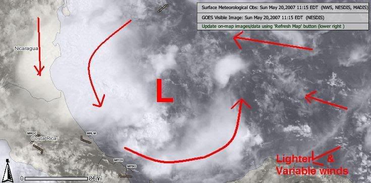
TROPICAL WEATHER DISCUSSION
NWS TPC/NATIONAL HURRICANE CENTER MIAMI FL
205 PM EDT SUN MAY 20 2007
THE CARIBBEAN SEA...
BROAD UPPER LEVEL ANTICYCLONIC FLOW COVERS THE AREA. A SURFACE
TROUGH EXTENDS FROM 20N80W 15N81W TO A 1010 MB LOW PRESSURE
CENTER IN THE SOUTHWESTERN CORNER OF THE AREA NEAR 11N81W.
NUMEROUS STRONG SHOWERS AND THUNDERSTORMS FROM 16N TO 18N
BETWEEN JAMAICA AND 80W...FROM 12N TO 13N BETWEEN 75W AND 77W...
AND FROM 9N TO 13N BETWEEN 81W AND 85W JUST OFF THE CENTRAL
AMERICA COAST FROM PANAMA TO SOUTHEASTERN NICARAGUA.
A DISSIPATING SURFACE TROUGH STRETCHES FROM CUBA NEAR 20N77W
TO THE BAHAMAS NEAR 23N74W...AND INTO THE ATLANTIC OCEAN NEAR
31N63W. POSSIBLE SHOWERS NORTH OF 17N BETWEEN 73W AND 82W.
ISOLATED MODERATE SHOWERS TO LOCALLY STRONG THUNDERSTORMS
ARE WITHIN 15 NM ON EITHER SIDE OF 18N81W 16N83W 15N83W NEAR
THE NORTHEASTERN CORNER OF NICARAGUA.
Atlantic Tropical Weather Discussion
0 likes
Who is online
Users browsing this forum: USTropics, Yellow Evan and 328 guests