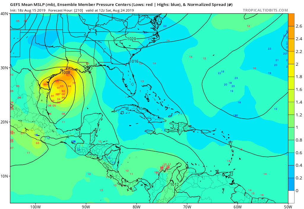
TheProfessor wrote:18z GEFS definitely had an uptick in stronger systems. Mostly aimed at Texas and Louisiana.
U have image ?
Moderator: S2k Moderators

TheProfessor wrote:18z GEFS definitely had an uptick in stronger systems. Mostly aimed at Texas and Louisiana.


stormlover2013 wrote:TheProfessor wrote:18z GEFS definitely had an uptick in stronger systems. Mostly aimed at Texas and Louisiana.
U have image ?


gatorcane wrote:No wonder the models don’t develop this wave in the Caribbean. That is some ripping shear!
MDR closed for business at the moment:
https://i.postimg.cc/HW9MyvGz/wg8shr.gif

TheProfessor wrote:18z GEFS definitely had an uptick in stronger systems. Mostly aimed at Texas and Louisiana.
LarryWx wrote:TheProfessor wrote:18z GEFS definitely had an uptick in stronger systems. Mostly aimed at Texas and Louisiana.
If you think the 18Z GEFS uptick was impressive, check out the 0Z GEFS, which is loaded with TS+'s in the W GOM!


LarryWx wrote:TheProfessor wrote:18z GEFS definitely had an uptick in stronger systems. Mostly aimed at Texas and Louisiana.
If you think the 18Z GEFS uptick was impressive, check out the 0Z GEFS, which is loaded with TS+'s in the W GOM!
stormlover2013 wrote:LarryWx wrote:TheProfessor wrote:18z GEFS definitely had an uptick in stronger systems. Mostly aimed at Texas and Louisiana.
If you think the 18Z GEFS uptick was impressive, check out the 0Z GEFS, which is loaded with TS+'s in the W GOM!
Image ?
USTropics wrote:00z GFS ensembles, very strong signal:
https://i.ibb.co/T16GCK3/gfs-ememb-lowlocs-watl-fh66-204.gif
TheProfessor wrote:USTropics wrote:00z GFS ensembles, very strong signal:
https://i.ibb.co/T16GCK3/gfs-ememb-lowlocs-watl-fh66-204.gif
The ensemble members seem to weaken the EPAC storm fairly quickly, which may be allowing a potential storm in the Gulf to flourish.

USTropics wrote:TheProfessor wrote:USTropics wrote:00z GFS ensembles, very strong signal:
https://i.ibb.co/T16GCK3/gfs-ememb-lowlocs-watl-fh66-204.gif
The ensemble members seem to weaken the EPAC storm fairly quickly, which may be allowing a potential storm in the Gulf to flourish.
The operational was hinting at this as well, a quick spinup that gets further NW and weakens significantly. Also GEFS 500mb anomalies not displacing the subtropical high as far west (was displaced into the EGOM 5 runs ago):
https://i.ibb.co/JKyY41F/gfs-ens-z500a-Norm-atl-fh168-trend-1.gif

South Texas Storms wrote:It's important to note that the GFS Ensembles have not been upgraded the to FV3 core yet.


Users browsing this forum: No registered users and 104 guests


