Wave well east of Lesser Antilles (Is INVEST 96L)
Moderator: S2k Moderators
Forum rules

The posts in this forum are NOT official forecasts and should not be used as such. They are just the opinion of the poster and may or may not be backed by sound meteorological data. They are NOT endorsed by any professional institution or STORM2K. For official information, please refer to products from the National Hurricane Center and National Weather Service.


Re: Wave Exiting Africa
They said I was dumb for stocking up on water during Dorian. "It's gonna turn", they said. Little did they know, I was playing the long game the whole time
14 likes
-
toad strangler

- S2K Supporter

- Posts: 4546
- Joined: Sun Jul 28, 2013 3:09 pm
- Location: Earth
- Contact:
Re: Wave Exiting Africa
That kind of track is tough to nail within 72 hours let alone 11 or 12 days lol
Take the track with a grain of salt. It could be into MX or Bermuda by 18z GFS tomorrow.
Take the track with a grain of salt. It could be into MX or Bermuda by 18z GFS tomorrow.
4 likes
My Weather Station
https://www.wunderground.com/dashboard/pws/KFLPORTS603
https://www.wunderground.com/dashboard/pws/KFLPORTS603
Re: Wave Exiting Africa
toad strangler wrote:That kind of track is tough to nail within 72 hours let alone 11 or 12 days lol
Take the track with a grain of salt. It could be into MX or Bermuda by 18z GFS tomorrow.
Absolutely.
If the GFS had its way, south florida would be a wasteland by now
4 likes
-
Astromanía
- Category 2

- Posts: 793
- Age: 27
- Joined: Sat Aug 25, 2018 10:34 pm
- Location: Monterrey, N.L, México
Re: Wave Exiting Africa
toad strangler wrote:That kind of track is tough to nail within 72 hours let alone 11 or 12 days lol
Take the track with a grain of salt. It could be into MX or Bermuda by 18z GFS tomorrow.
No thanks
0 likes
-
SouthFLTropics

- Category 5

- Posts: 4258
- Age: 50
- Joined: Thu Aug 14, 2003 8:04 am
- Location: Port St. Lucie, Florida
Re: Wave Exiting Africa
sma10 wrote:toad strangler wrote:That kind of track is tough to nail within 72 hours let alone 11 or 12 days lol
Take the track with a grain of salt. It could be into MX or Bermuda by 18z GFS tomorrow.
Absolutely.
If the GFS had its way, south florida would be a wasteland by now
If you haven't already noticed...South Florida IS a wasteland!!!
4 likes
Fourth Generation Florida Native
Personal Storm History: David 79, Andrew 92, Erin 95, Floyd 99, Irene 99, Frances 04, Jeanne 04, Wilma 05, Matthew 16, Irma 17, Ian 22, Nicole 22, Milton 24
Personal Storm History: David 79, Andrew 92, Erin 95, Floyd 99, Irene 99, Frances 04, Jeanne 04, Wilma 05, Matthew 16, Irma 17, Ian 22, Nicole 22, Milton 24
Re: Wave Exiting Africa
sma10 wrote:LarryWx wrote:I finally saw the 12Z UKMET. It is much weaker than the last few runs but related to that it is quite a bit further SW (Leewards at day 7). Although it is weaker and it is a left biased model, this trend is definitely not what we should want to see if we don't want the Caribbean and CONUS to be threatened.
Larry did this include the uk ensembles as well as the operational?
Sorry, I just saw this from you. No, it is just the operational. I haven't seen UK ensembles.
0 likes
Personal Forecast Disclaimer:
The posts in this forum are NOT official forecasts and should not be used as such. They are just the opinion of the poster and may or may not be backed by sound meteorological data. They are NOT endorsed by any professional institution or storm2k.org. For official information, please refer to the NHC and NWS products.
The posts in this forum are NOT official forecasts and should not be used as such. They are just the opinion of the poster and may or may not be backed by sound meteorological data. They are NOT endorsed by any professional institution or storm2k.org. For official information, please refer to the NHC and NWS products.
-
USTropics
- Professional-Met

- Posts: 2736
- Joined: Sun Aug 12, 2007 3:45 am
- Location: Florida State University
Re: Wave Exiting Africa
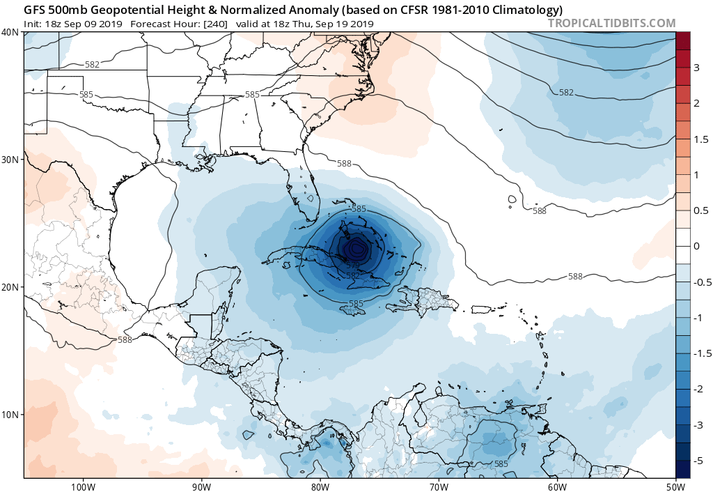
How the WPAC systems Lingling and Faxai are absorbed into the higher latitudes could play a crucial role in the eventual track of this AEW. Here is an analysis of the 2 systems 72 hours ago, and their eventual track towards an approaching trough:

Fast forward to current analysis, and we'll see the remnants of Lingling being absorbed and Faxai heading north into the weakness:

The 12z GFS has both systems being absorbed in 48 hours:

Now watch a full animation and you can see how this evolution has implications downstream on the eventual track of this AEW. Keep in mind this is a long range forecast, and just one possible solution. Trough position/tilt/strength could erode or amplify the high pressure area over the Eastern US, it could even create a blocking pattern:

Fast forward to current analysis, and we'll see the remnants of Lingling being absorbed and Faxai heading north into the weakness:
The 12z GFS has both systems being absorbed in 48 hours:
Now watch a full animation and you can see how this evolution has implications downstream on the eventual track of this AEW. Keep in mind this is a long range forecast, and just one possible solution. Trough position/tilt/strength could erode or amplify the high pressure area over the Eastern US, it could even create a blocking pattern:
10 likes

-
toad strangler
- S2K Supporter
- Posts: 4546
- Joined: Sun Jul 28, 2013 3:09 pm
- Location: Earth
- Contact:
Re: Wave Exiting Africa
Bigwhitey wrote:Chances of a 258 hour model verifying
Yeah everyone knows that and has been said already.
At this stage it’s all about signals. Track and intensity are fools gold this far out. The signals are strong though and the Euro is close to hopping on board.
6 likes
My Weather Station
https://www.wunderground.com/dashboard/pws/KFLPORTS603
https://www.wunderground.com/dashboard/pws/KFLPORTS603
-
cycloneye

- Admin

- Posts: 149222
- Age: 69
- Joined: Thu Oct 10, 2002 10:54 am
- Location: San Juan, Puerto Rico
Re: Wave Exiting Africa
A tropical wave located just off the west coast of Africa is
expected to move quickly westward during the next several days.
Some slow development is possible late this week and over the
weekend when the system is several hundred miles east of the
Lesser Antilles.
* Formation chance through 48 hours...low...near 0 percent.
* Formation chance through 5 days...low...20 percent.

0 likes
Visit the Caribbean-Central America Weather Thread where you can find at first post web cams,radars
and observations from Caribbean basin members Click Here
and observations from Caribbean basin members Click Here

Re: Wave Exiting Africa
USTropics wrote:How the WPAC systems Lingling and Faxai are absorbed into the higher latitudes could play a crucial role in the eventual track of this AEW. Here is an analysis of the 2 systems 72 hours ago, and their eventual track towards an approaching trough:
Nothing says fall like a nice typhoon enhanced Rossby Wave train.
5 likes
-
jlauderdal
- S2K Supporter
- Posts: 7240
- Joined: Wed May 19, 2004 5:46 am
- Location: NE Fort Lauderdale
- Contact:
Re: RE: Re: Wave Exiting Africa
Gfs loves south florida, new or legacy doesnt matterWeatherEmperor wrote:Gfs has a sense of humor
Sent from my iPhone using Tapatalk

2 likes
-
gatorcane

- S2K Supporter
- Posts: 23708
- Age: 48
- Joined: Sun Mar 13, 2005 3:54 pm
- Location: Boca Raton, FL
Re: Wave Exiting Africa
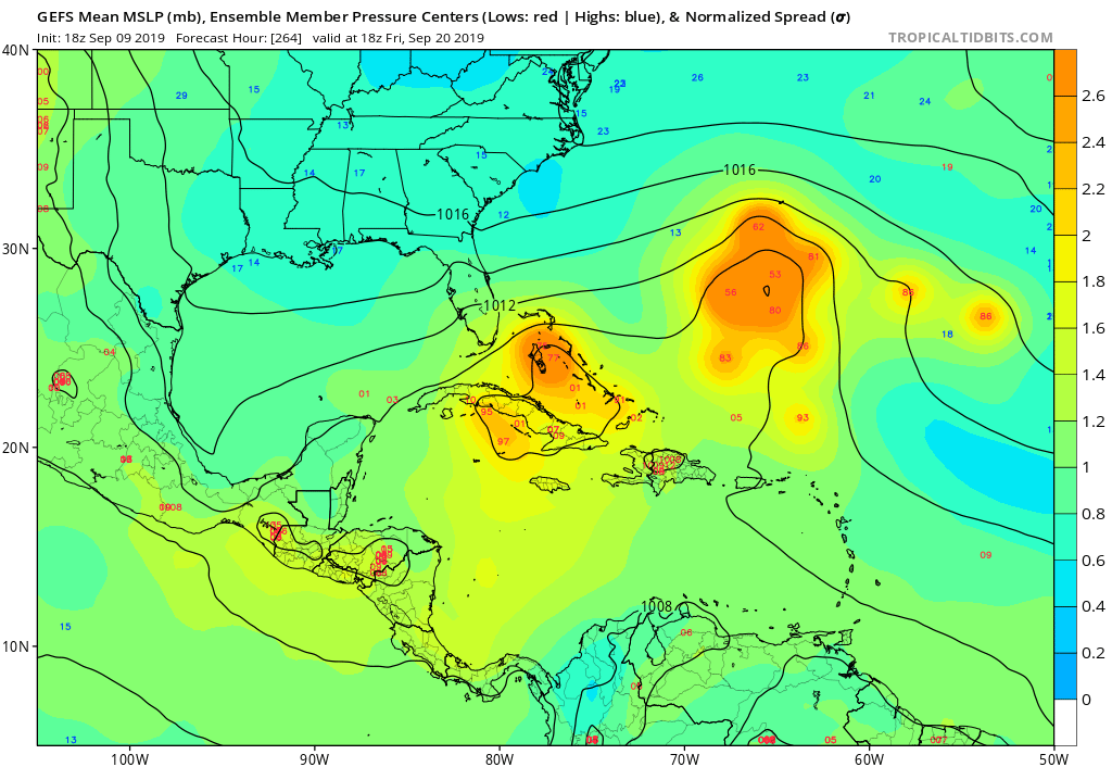
18Z GEFS showing two camps in the long-range. One group heads south through the islands and eventually Bahamas and South Florida. The other go north and recurve sooner north of islands. Looks like a very complex steering pattern ahead with recurving typhoons. Expect wild swings in models to continue...
4 likes
-
cycloneye
- Admin
- Posts: 149222
- Age: 69
- Joined: Thu Oct 10, 2002 10:54 am
- Location: San Juan, Puerto Rico
Re: Wave Exiting Africa
0 likes
Visit the Caribbean-Central America Weather Thread where you can find at first post web cams,radars
and observations from Caribbean basin members Click Here
and observations from Caribbean basin members Click Here
-
gatorcane
- S2K Supporter
- Posts: 23708
- Age: 48
- Joined: Sun Mar 13, 2005 3:54 pm
- Location: Boca Raton, FL
Re: Wave Exiting Africa
There is your classic “thumb ridge” as shown by 18Z GFS day 10 which drives the hurricane into South Florida. Luckily this is a day 10 forecast which is likely not to verify exactly as shown:
0 likes

Re: Wave Exiting Africa
RL3AO wrote:USTropics wrote:How the WPAC systems Lingling and Faxai are absorbed into the higher latitudes could play a crucial role in the eventual track of this AEW. Here is an analysis of the 2 systems 72 hours ago, and their eventual track towards an approaching trough:
Nothing says fall like a nice typhoon enhanced Rossby Wave train.
Complicated teleconnections you say? Models to say the least are highly uncertain. Sometimes I think all models should never go past 7 days.
0 likes
Re: Wave Exiting Africa
I'm very concerned about a storm going into the Gulf. IF the next storm tracks through the western Caribbean and Gulf, it would be going through water that hasn't been tapped in quite awhile, Also, there also have been no sig cold fronts to cool the waters and it has been much warmer than normal in the SE US. Thus the SSTs are boiling...I mean nearly 1 C warmer than they were just before Michael came through in some areas! Most of the open Gulf and W Caribbean is ~86-87 range with some open areas even close to 88! Just before Michael, Gulf SSTs were at or near record warmth for early Oct. due to a record hot Sept/early Oct, but even that was more like 84-6. Also to compare, the warmest open ocean SSTs in Dorian's path were near 86-7 (Bahamas). That's quite concerning, especially if it is not crawling slowly enough to lead to weakening due to its own wake.
Unless that wave now north of the Greater Antilles were to develop much and cool the Gulf some, the Gulf will likely still be about this hot if the far E Atlantic entity were to track this way as I don't see any sig cold fronts during the next 14+ days with well above normal temps continuing.
Related to this:
https://www.nola.com/news/environment/a ... 22441.html
3 likes
Personal Forecast Disclaimer:
The posts in this forum are NOT official forecasts and should not be used as such. They are just the opinion of the poster and may or may not be backed by sound meteorological data. They are NOT endorsed by any professional institution or storm2k.org. For official information, please refer to the NHC and NWS products.
The posts in this forum are NOT official forecasts and should not be used as such. They are just the opinion of the poster and may or may not be backed by sound meteorological data. They are NOT endorsed by any professional institution or storm2k.org. For official information, please refer to the NHC and NWS products.
Who is online
Users browsing this forum: No registered users and 127 guests