2021 EPAC Season

This is the general tropical discussion area. Anyone can take their shot at predicting a storms path.

Moderator: S2k Moderators

Forum rules

The posts in this forum are NOT official forecasts and should not be used as such. They are just the opinion of the poster and may or may not be backed by sound meteorological data. They are NOT endorsed by any professional institution or STORM2K. For official information, please refer to products from the National Hurricane Center and National Weather Service.

Help Support Storm2K
Message
Author
User avatar
cycloneye
Admin
Admin
Posts: 145285
Age: 68
Joined: Thu Oct 10, 2002 10:54 am
Location: San Juan, Puerto Rico

Re: 2021 EPAC Season

#181 Postby cycloneye » Thu May 27, 2021 7:02 pm

Tropical Weather Outlook
NWS National Hurricane Center Miami FL
500 PM PDT Thu May 27 2021

For the eastern North Pacific...east of 140 degrees west longitude:

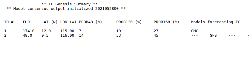
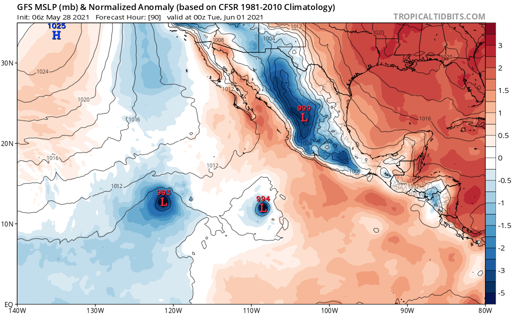
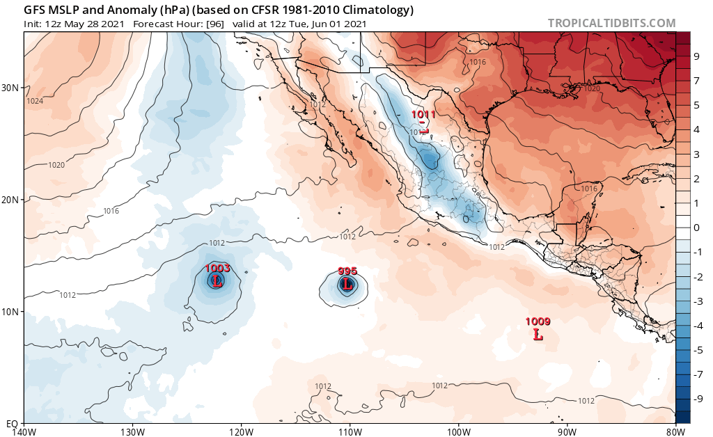
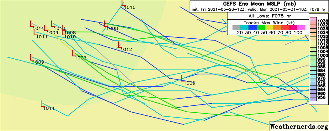
1. A broad area of low pressure located about one thousand miles south
of the southern tip of the Baja California peninsula is producing
some disorganized showers and thunderstorms. Environmental
conditions appear only marginally conducive for development of this
system as it moves westward or west-northwestward at about 10 mph
during the next several days.
* Formation chance through 48 hours...low...10 percent.
* Formation chance through 5 days...low...20 percent.

2. Another area of low pressure is expected to form several hundred
miles south of the coast of southeastern Mexico during the next few
days. Some gradual development of this system is possible as it
moves generally westward at 5 to 10 mph.
* Formation chance through 48 hours...low...near 0 percent.
* Formation chance through 5 days...low...30 percent.

Forecaster Reinhart/Beven
0 likes   
Visit the Caribbean-Central America Weather Thread where you can find at first post web cams,radars
and observations from Caribbean basin members Click Here

JW-_-

Re: 2021 EPAC Season

#182 Postby JW-_- » Thu May 27, 2021 8:03 pm

TC Genesis Summary Model consensus output initialized 2021052800

Image
0 likes   

User avatar
Kingarabian
S2K Supporter
S2K Supporter
Posts: 15979
Joined: Sat Aug 08, 2009 3:06 am
Location: Honolulu, Hawaii

Re: 2021 EPAC Season

#183 Postby Kingarabian » Fri May 28, 2021 5:37 am

06z GFS thinks its mid season:
Image
0 likes   
RIP Kobe Bryant

User avatar
Kingarabian
S2K Supporter
S2K Supporter
Posts: 15979
Joined: Sat Aug 08, 2009 3:06 am
Location: Honolulu, Hawaii

Re: 2021 EPAC Season

#184 Postby Kingarabian » Fri May 28, 2021 5:38 am

Tropical Weather Outlook
NWS National Hurricane Center Miami FL
1100 PM PDT Thu May 27 2021

For the eastern North Pacific...east of 140 degrees west longitude:

1. Shower activity associated with a broad area of low pressure
located about 900 miles south of the southern tip of the Baja
California peninsula has become a little more concentrated since
yesterday. Some additional slow development could occur during
the next few days as the system moves westward or west-northwestward
at about 10 mph.
* Formation chance through 48 hours...low...20 percent.
* Formation chance through 5 days...low...30 percent.

2. Another area of low pressure is expected to form several hundred
miles south of the coast of southeastern Mexico during the next few
days. Some gradual development of this system is possible as it
moves generally westward at 5 to 10 mph.
* Formation chance through 48 hours...low...near 0 percent.
* Formation chance through 5 days...low...30 percent.

Forecaster Beven
0 likes   
RIP Kobe Bryant

User avatar
cycloneye
Admin
Admin
Posts: 145285
Age: 68
Joined: Thu Oct 10, 2002 10:54 am
Location: San Juan, Puerto Rico

Re: 2021 EPAC Season

#185 Postby cycloneye » Fri May 28, 2021 6:33 am

Tropical Weather Outlook
NWS National Hurricane Center Miami FL
500 AM PDT Fri May 28 2021

For the eastern North Pacific...east of 140 degrees west longitude:

Shower activity has changed little in organization during the past
several hours in association with a broad area of low pressure
located about 950 miles south-southwest of the southern tip of the
Baja California peninsula. Some slow development of this system is
possible during the next few days while it moves westward
or west-northwestward at about 10 mph.
* Formation chance through 48 hours...low...20 percent.
* Formation chance through 5 days...low...30 percent.

A trough of low pressure is producing a large area of disorganized
showers and thunderstorms several hundred miles south of Acapulco,
Mexico. Some gradual development of this system is possible
during the next several days while it moves slowly westward or
west-northwestward.
* Formation chance through 48 hours...low...near 0 percent.
* Formation chance through 5 days...low...30 percent.

$$
Forecaster Cangialosi
0 likes   
Visit the Caribbean-Central America Weather Thread where you can find at first post web cams,radars
and observations from Caribbean basin members Click Here

User avatar
cycloneye
Admin
Admin
Posts: 145285
Age: 68
Joined: Thu Oct 10, 2002 10:54 am
Location: San Juan, Puerto Rico

Re: 2021 EPAC Season

#186 Postby cycloneye » Fri May 28, 2021 12:26 pm

Tropical Weather Outlook
NWS National Hurricane Center Miami FL
1100 AM PDT Fri May 28 2021

For the eastern North Pacific...east of 140 degrees west longitude:

Shower activity is limited in association with a broad area of low
pressure located about 1000 miles south-southwest of the southern
tip of the Baja California peninsula. This system is moving
west-northwestward at about 10 mph and some slow development is
possible during the next few days before it moves into a drier and
more stable airmass early next week.
* Formation chance through 48 hours...low...20 percent.
* Formation chance through 5 days...low...30 percent.

A trough of low pressure is producing a large area of disorganized
showers and thunderstorms several hundred miles south of Acapulco,
Mexico. Gradual development of this system is possible during the
next several days while it moves slowly west-northwestward to the
south of Mexico.
* Formation chance through 48 hours...low...10 percent.
* Formation chance through 5 days...medium...40 percent.

$$
Forecaster Cangialosi
0 likes   
Visit the Caribbean-Central America Weather Thread where you can find at first post web cams,radars
and observations from Caribbean basin members Click Here

User avatar
Yellow Evan
Professional-Met
Professional-Met
Posts: 16143
Age: 27
Joined: Fri Jul 15, 2011 12:48 pm
Location: Henderson, Nevada/Honolulu, HI
Contact:

Re: 2021 EPAC Season

#187 Postby Yellow Evan » Fri May 28, 2021 1:29 pm

Image

12z GFS still showing 2 storms, with the 10/40 eventually recurving although weakening prior to landfall.
0 likes   

User avatar
Yellow Evan
Professional-Met
Professional-Met
Posts: 16143
Age: 27
Joined: Fri Jul 15, 2011 12:48 pm
Location: Henderson, Nevada/Honolulu, HI
Contact:

Re: 2021 EPAC Season

#188 Postby Yellow Evan » Fri May 28, 2021 1:30 pm

Last 2 ECMWF runs never show anything more than a low with either system.
0 likes   

User avatar
Kingarabian
S2K Supporter
S2K Supporter
Posts: 15979
Joined: Sat Aug 08, 2009 3:06 am
Location: Honolulu, Hawaii

Re: 2021 EPAC Season

#189 Postby Kingarabian » Fri May 28, 2021 5:59 pm

Latest model runs other than the GFS barely develop the 2-3 AOI's in the EPAC, but they don't drop the systems entirely. They just keep them weak. So the NHC odds are pretty good IMO.

Deep level shear is favorable:
Image

The two NHC circled areas are moving into areas with decreasing mid level shear although its a very tight area:
Image
1 likes   
RIP Kobe Bryant

JW-_-

Re: 2021 EPAC Season

#190 Postby JW-_- » Fri May 28, 2021 6:55 pm

Image


Image


Image
Probs have been very consistent with Tropical Depression.
1 likes   

User avatar
Kingarabian
S2K Supporter
S2K Supporter
Posts: 15979
Joined: Sat Aug 08, 2009 3:06 am
Location: Honolulu, Hawaii

Re: 2021 EPAC Season

#191 Postby Kingarabian » Sat May 29, 2021 1:07 am

00z GFS and CMC favoring the 2nd system much more now.
0 likes   
RIP Kobe Bryant

JW-_-

Re: 2021 EPAC Season

#192 Postby JW-_- » Sat May 29, 2021 2:20 am

Just hoping we see at-lest one get to first base a (td). Then make it to a named ts for the basin.

Image


Image
0 likes   

User avatar
Kingarabian
S2K Supporter
S2K Supporter
Posts: 15979
Joined: Sat Aug 08, 2009 3:06 am
Location: Honolulu, Hawaii

Re: 2021 EPAC Season

#193 Postby Kingarabian » Sat May 29, 2021 2:44 am

00z Euro keeps the first system weak but again develops the 2nd system:
Image
0 likes   
RIP Kobe Bryant

JW-_-

Re: 2021 EPAC Season

#194 Postby JW-_- » Sat May 29, 2021 3:02 am

It does see an increase in latent heat flux. So yeah keeps following here until all the seeds are gone.
Image
2 likes   

User avatar
cycloneye
Admin
Admin
Posts: 145285
Age: 68
Joined: Thu Oct 10, 2002 10:54 am
Location: San Juan, Puerto Rico

Re: 2021 EPAC Season

#195 Postby cycloneye » Sat May 29, 2021 6:38 am

Tropical Weather Outlook
NWS National Hurricane Center Miami FL
500 AM PDT Sat May 29 2021

For the eastern North Pacific...east of 140 degrees west longitude:

A small cluster of showers and thunderstorms located about 1000
miles south-southwest of the southern tip of the Baja California
peninsula is associated with a weak area of low pressure. This
system is moving westward at 5 to 10 mph, and some slow development
remains possible over the next few days before it moves into a drier
and more stable airmass by early next week.
* Formation chance through 48 hours...low...20 percent.
* Formation chance through 5 days...low...30 percent.

A broad area of low pressure located several hundred miles south of
Acapulco, Mexico, is producing disorganized shower and thunderstorm
activity. Environmental conditions are expected to be conducive for
gradual development of this system during the next several days, and
a tropical depression could form by the middle of next week while
the system moves westward to west-northwestward at about 10 mph.
* Formation chance through 48 hours...low...20 percent.
* Formation chance through 5 days...medium...50 percent.

$$
Forecaster Berg
0 likes   
Visit the Caribbean-Central America Weather Thread where you can find at first post web cams,radars
and observations from Caribbean basin members Click Here

User avatar
cycloneye
Admin
Admin
Posts: 145285
Age: 68
Joined: Thu Oct 10, 2002 10:54 am
Location: San Juan, Puerto Rico

Re: 2021 EPAC Season

#196 Postby cycloneye » Sat May 29, 2021 7:50 am

For the 20/50 one.

A. TROPICAL DISTURBANCE

B. 29/1130Z

C. 8.8N

D. 100.2W

E. THREE/GOES-W

F. T1.0/1.0

G. IR/EIR/SWIR

H. REMARKS...>2/10 FOR A DT=1.0. MET AND PT AGREE. FT IS BASED ON DT.

I. ADDL POSITIONS

NIL


...LEE
0 likes   
Visit the Caribbean-Central America Weather Thread where you can find at first post web cams,radars
and observations from Caribbean basin members Click Here

User avatar
Yellow Evan
Professional-Met
Professional-Met
Posts: 16143
Age: 27
Joined: Fri Jul 15, 2011 12:48 pm
Location: Henderson, Nevada/Honolulu, HI
Contact:

Re: 2021 EPAC Season

#197 Postby Yellow Evan » Sat May 29, 2021 12:23 pm

Image
0 likes   

User avatar
cycloneye
Admin
Admin
Posts: 145285
Age: 68
Joined: Thu Oct 10, 2002 10:54 am
Location: San Juan, Puerto Rico

Re: 2021 EPAC Season

#198 Postby cycloneye » Sat May 29, 2021 12:41 pm

Code red.

Tropical Weather Outlook
NWS National Hurricane Center Miami FL
1100 AM PDT Sat May 29 2021

For the eastern North Pacific...east of 140 degrees west longitude:

Shower activity associated with a weak area of low pressure located
about 1000 miles south-southwest of the southern tip of the Baja
California peninsula remains disorganized. This system is expected
to move generally westward at 5 to 10 mph into a drier and more
stable airmass during the next few days, and its chance of
development appears to be decreasing.
* Formation chance through 48 hours...low...10 percent.
* Formation chance through 5 days...low...20 percent.

A broad area of low pressure located several hundred miles south of
Acapulco, Mexico, continues to produce disorganized shower and
thunderstorm activity. However, environmental conditions are
expected to be conducive for development of this system during the
next several days, and a tropical depression is likely to form by
the middle of next week while the system moves westward to
west-northwestward at about 10 mph.
* Formation chance through 48 hours...medium...40 percent.
* Formation chance through 5 days...high...70 percent.

$$
Forecaster Berg
0 likes   
Visit the Caribbean-Central America Weather Thread where you can find at first post web cams,radars
and observations from Caribbean basin members Click Here

User avatar
cycloneye
Admin
Admin
Posts: 145285
Age: 68
Joined: Thu Oct 10, 2002 10:54 am
Location: San Juan, Puerto Rico

Re: 2021 EPAC Season

#199 Postby cycloneye » Sat May 29, 2021 1:47 pm

0 likes   
Visit the Caribbean-Central America Weather Thread where you can find at first post web cams,radars
and observations from Caribbean basin members Click Here

User avatar
DorkyMcDorkface
Category 3
Category 3
Posts: 888
Age: 27
Joined: Mon Sep 30, 2019 1:32 pm
Location: Mid-Atlantic

Re: 2021 EPAC Season

#200 Postby DorkyMcDorkface » Sun May 30, 2021 10:45 am

Hmmmm....(this is the 10/10, not 91E)

Image
0 likes   
Please note the thougths expressed by this account are solely those of the user and are from a hobbyist perspective. For more comprehensive analysis, consult an actual professional meteorologist or meteorology agency.


Floyd 1999 | Isabel 2003 | Hanna 2008 | Irene 2011 | Sandy 2012 | Isaias 2020


Return to “Talkin' Tropics”

Who is online

Users browsing this forum: No registered users and 51 guests