2020 Global Model Runs Discussion (Out thru day 16)

This is the general tropical discussion area. Anyone can take their shot at predicting a storms path.

Moderator: S2k Moderators

Forum rules

The posts in this forum are NOT official forecasts and should not be used as such. They are just the opinion of the poster and may or may not be backed by sound meteorological data. They are NOT endorsed by any professional institution or STORM2K. For official information, please refer to products from the National Hurricane Center and National Weather Service.

Help Support Storm2K
Message
Author
LarryWx
S2K Supporter
S2K Supporter
Posts: 6318
Joined: Sun Sep 07, 2003 2:04 pm
Location: GA

Re: 2020 Global Model Runs Discussion (Out thru day 16)

#1821 Postby LarryWx » Tue Sep 01, 2020 12:18 pm

I'm starting to wonder if the GFS para is a genesis happy model like the CMC.

The Euro seems to be a genesis unhappy model these days. Split the difference?

Can't we just have an emotionless model when it comes to genesis? :lol:
0 likes   
Personal Forecast Disclaimer:
The posts in this forum are NOT official forecasts and should not be used as such. They are just the opinion of the poster and may or may not be backed by sound meteorological data. They are NOT endorsed by any professional institution or storm2k.org. For official information, please refer to the NHC and NWS products.

Astromanía
Category 2
Category 2
Posts: 779
Age: 26
Joined: Sat Aug 25, 2018 10:34 pm
Location: Monterrey, N.L, México

Re: 2020 Global Model Runs Discussion (Out thru day 16)

#1822 Postby Astromanía » Tue Sep 01, 2020 12:24 pm

SFLcane wrote:
HurricaneFrances04 wrote:The 6Z GFS Parallel has us on the V storm by September 17th :double:


[url]https://i.postimg.cc/026RQZXC/5-C0-E9-BC2-5921-44-BB-867-B-4834948574-E3.gif [/url]


Whats that major coming to my area at september 17th :eek:
0 likes   

ThetaE
Tropical Storm
Tropical Storm
Posts: 244
Joined: Sat Sep 24, 2016 4:50 pm
Location: Boston

Re: 2020 Global Model Runs Discussion (Out thru day 16)

#1823 Postby ThetaE » Tue Sep 01, 2020 12:57 pm

LarryWx wrote:I'm starting to wonder if the GFS para is a genesis happy model like the CMC.

The Euro seems to be a genesis unhappy model these days. Split the difference?

Can't we just have an emotionless model when it comes to genesis? :lol:


Sadly, this is probably a long ways away from happening...

For those interested in more of the nuts and bolts of the parallel model, here's a link to retrospective forecasts of past TCs, comparing the operational ("GFSv15") and parallel ("GFSv16") models to one another, and to observations/analysis: https://www.emc.ncep.noaa.gov/users/meg/gfsv16/retros/

Some powerpoints walking through these case studies can also be found by navigating to the "GFSv16 Official Evaluation Page." The general takeaway is that the parallel GFS captures intensification in unexpected RI storms (e.g. Dorian, Michael) at longer lead times than the operational model, but that the parallel has a "tendency to strengthen all TCs that develop in both basins" and has a fast and poleward bias. It doesn't look like these studies focused much on cases where genesis was predicted but didn't materialize, but you're probably right that the GFS parallel is too eager (I mean, 6 new storms by the 17th? :lol:).
4 likes   
I'm a busy grad student, not a professional forecaster. Please refer to the NHC and NWS for official forecasts.

User avatar
Ivanhater
Storm2k Moderator
Storm2k Moderator
Posts: 11162
Age: 38
Joined: Fri Jul 01, 2005 8:25 am
Location: Pensacola

Re: 2020 Global Model Runs Discussion (Out thru day 16)

#1824 Postby Ivanhater » Tue Sep 01, 2020 2:13 pm

That huge trough from yesterday completely breaks down and is replaced with a huge ridge for the Southeast on today's run. Much more believable Image

Sent from my SM-G955U using Tapatalk
1 likes   
Michael

User avatar
northjaxpro
S2K Supporter
S2K Supporter
Posts: 8900
Joined: Mon Sep 27, 2010 11:21 am
Location: Jacksonville, FL

Re: 2020 Global Model Runs Discussion (Out thru day 16)

#1825 Postby northjaxpro » Tue Sep 01, 2020 2:28 pm

Ivanhater wrote:That huge trough from yesterday completely breaks down and is replaced with a huge ridge for the Southeast on today's run. Much more believable https://uploads.tapatalk-cdn.com/20200901/f42047d1bcc3fb3b64b4d62fc891ab57.jpg

Sent from my SM-G955U using Tapatalk


Potentially could have either Omar(if T.D. 15 isn't upgraded)
or Paulette on this run approaching the Northern Lesser Antilles.

Big ridge looks to establish itself once again on this run.This is one potential cyclone we really have to watch next week.
0 likes   
NEVER, EVER SAY NEVER in the tropics and weather in general, and most importantly, with life itself!!

________________________________________________________________________________________

Fay 2008 Beryl 2012 Debby 2012 Colin 2016 Hermine 2016 Julia 2016 Matthew 2016 Irma 2017 Dorian 2019

User avatar
NDG
S2K Supporter
S2K Supporter
Posts: 15446
Joined: Sun Jul 09, 2006 10:14 pm
Location: Orlando, FL

Re: 2020 Global Model Runs Discussion (Out thru day 16)

#1826 Postby NDG » Tue Sep 01, 2020 2:34 pm

How about that early fall pattern for the eastern US? Nothing but wishful thinking as continued shown by the ensembles, unfortunately but not surprising to some of us.
0 likes   

User avatar
northjaxpro
S2K Supporter
S2K Supporter
Posts: 8900
Joined: Mon Sep 27, 2010 11:21 am
Location: Jacksonville, FL

Re: 2020 Global Model Runs Discussion (Out thru day 16)

#1827 Postby northjaxpro » Tue Sep 01, 2020 2:39 pm

NDG wrote:How about that early fall pattern for the eastern US? Nothing but wishful thinking as continued shown by the ensembles, unfortunately but not surprising to some of us.


NDG , not at all to me either.
1 likes   
NEVER, EVER SAY NEVER in the tropics and weather in general, and most importantly, with life itself!!

________________________________________________________________________________________

Fay 2008 Beryl 2012 Debby 2012 Colin 2016 Hermine 2016 Julia 2016 Matthew 2016 Irma 2017 Dorian 2019

User avatar
EquusStorm
Category 5
Category 5
Posts: 1649
Age: 34
Joined: Thu Nov 07, 2013 1:04 pm
Location: Jasper, AL
Contact:

Re: 2020 Global Model Runs Discussion (Out thru day 16)

#1828 Postby EquusStorm » Tue Sep 01, 2020 2:41 pm

Considering the trend of immediately retiring replacement names, Paulette will definitely be one to watch lol
1 likes   
Colors of lost purpose on the canvas of irrelevance

Not a meteorologist, in fact more of an idiot than anything. You should probably check with the NHC or a local NWS office for official information.

St0rmTh0r
Category 1
Category 1
Posts: 369
Joined: Tue Jul 14, 2020 8:04 pm

Re: 2020 Global Model Runs Discussion (Out thru day 16)

#1829 Postby St0rmTh0r » Tue Sep 01, 2020 2:41 pm

At this point we are playing ourselves to the point of insanity if we believe the long range euro and gfs pattern
1 likes   

User avatar
northjaxpro
S2K Supporter
S2K Supporter
Posts: 8900
Joined: Mon Sep 27, 2010 11:21 am
Location: Jacksonville, FL

Re: 2020 Global Model Runs Discussion (Out thru day 16)

#1830 Postby northjaxpro » Tue Sep 01, 2020 2:50 pm

St0rmTh0r wrote:At this point we are playing ourselves to the point of insanity if we believe the long range euro and gfs pattern


Also, latest teleconnections index forecast has a very strong + NAO right through Sept 10, possibly longer. So, yeah, strong ridging will be likely.
1 likes   
NEVER, EVER SAY NEVER in the tropics and weather in general, and most importantly, with life itself!!

________________________________________________________________________________________

Fay 2008 Beryl 2012 Debby 2012 Colin 2016 Hermine 2016 Julia 2016 Matthew 2016 Irma 2017 Dorian 2019

User avatar
NDG
S2K Supporter
S2K Supporter
Posts: 15446
Joined: Sun Jul 09, 2006 10:14 pm
Location: Orlando, FL

Re: 2020 Global Model Runs Discussion (Out thru day 16)

#1831 Postby NDG » Tue Sep 01, 2020 3:19 pm

Euro ensembles show potentially 2-3 systems at the same time over in the Atlantic basin during the peak of the season.

Image
1 likes   

User avatar
SFLcane
S2K Supporter
S2K Supporter
Posts: 10163
Age: 47
Joined: Sat Jun 05, 2010 1:44 pm
Location: Lake Worth Florida

Re: 2020 Global Model Runs Discussion (Out thru day 16)

#1832 Postby SFLcane » Tue Sep 01, 2020 3:24 pm

NDG wrote:Euro ensembles show potentially 2-3 systems at the same time over in the Atlantic basin during the peak of the season.

https://i.imgur.com/LSAtgYI.png


Interesting westward bend on those ensembles nearing the Bahamas.
0 likes   

LarryWx
S2K Supporter
S2K Supporter
Posts: 6318
Joined: Sun Sep 07, 2003 2:04 pm
Location: GA

Re: 2020 Global Model Runs Discussion (Out thru day 16)

#1833 Postby LarryWx » Tue Sep 01, 2020 3:28 pm

Continuing further out on the 12Z EPS from what NDG just posted: suggests the CONUS, Bahamas, and Bermuda should be wary about midmonth from the wave coming off the African coast about now:

Image
Last edited by LarryWx on Tue Sep 01, 2020 3:31 pm, edited 1 time in total.
1 likes   
Personal Forecast Disclaimer:
The posts in this forum are NOT official forecasts and should not be used as such. They are just the opinion of the poster and may or may not be backed by sound meteorological data. They are NOT endorsed by any professional institution or storm2k.org. For official information, please refer to the NHC and NWS products.

User avatar
NDG
S2K Supporter
S2K Supporter
Posts: 15446
Joined: Sun Jul 09, 2006 10:14 pm
Location: Orlando, FL

Re: 2020 Global Model Runs Discussion (Out thru day 16)

#1834 Postby NDG » Tue Sep 01, 2020 3:28 pm

12z EPS.
Image
0 likes   

User avatar
SFLcane
S2K Supporter
S2K Supporter
Posts: 10163
Age: 47
Joined: Sat Jun 05, 2010 1:44 pm
Location: Lake Worth Florida

Re: 2020 Global Model Runs Discussion (Out thru day 16)

#1835 Postby SFLcane » Tue Sep 01, 2020 3:38 pm

LarryWx wrote:Continuing further out on the 12Z EPS from what NDG just posted: suggests the CONUS, Bahamas, and Bermuda should be wary about midmonth from the wave coming off the African coast about now:

https://i.imgur.com/F2SeZ4A.png


EPS trended a bit SW from 00z but still implying a potential threat to Bermuda.
1 likes   

User avatar
SFLcane
S2K Supporter
S2K Supporter
Posts: 10163
Age: 47
Joined: Sat Jun 05, 2010 1:44 pm
Location: Lake Worth Florida

Re: 2020 Global Model Runs Discussion (Out thru day 16)

#1836 Postby SFLcane » Tue Sep 01, 2020 3:41 pm


Just enough to weaken the ridge and allow for a potential storm to threaten Bermuda or head out to sea. This will continue change
0 likes   

User avatar
gatorcane
S2K Supporter
S2K Supporter
Posts: 23691
Age: 47
Joined: Sun Mar 13, 2005 3:54 pm
Location: Boca Raton, FL

Re: 2020 Global Model Runs Discussion (Out thru day 16)

#1837 Postby gatorcane » Tue Sep 01, 2020 3:43 pm

The GFS parallel still shows the trough in the 12Z run:

Image
1 likes   

User avatar
NDG
S2K Supporter
S2K Supporter
Posts: 15446
Joined: Sun Jul 09, 2006 10:14 pm
Location: Orlando, FL

Re: 2020 Global Model Runs Discussion (Out thru day 16)

#1838 Postby NDG » Tue Sep 01, 2020 3:45 pm

SFLcane wrote:


Just enough to weaken the ridge and allow for a potential storm to threaten Bermuda or head out to sea. This will continue change


That's not the way to look at it, usually on the ensembles the anomalies become less drastic on its long range image because there is less agreement on the exact position of the ridge, but not that it will weaken. The ridge will most likely still be there & strong somewhere between the SE US & Bermuda.
Last edited by NDG on Tue Sep 01, 2020 3:52 pm, edited 1 time in total.
2 likes   

User avatar
NDG
S2K Supporter
S2K Supporter
Posts: 15446
Joined: Sun Jul 09, 2006 10:14 pm
Location: Orlando, FL

Re: 2020 Global Model Runs Discussion (Out thru day 16)

#1839 Postby NDG » Tue Sep 01, 2020 3:51 pm

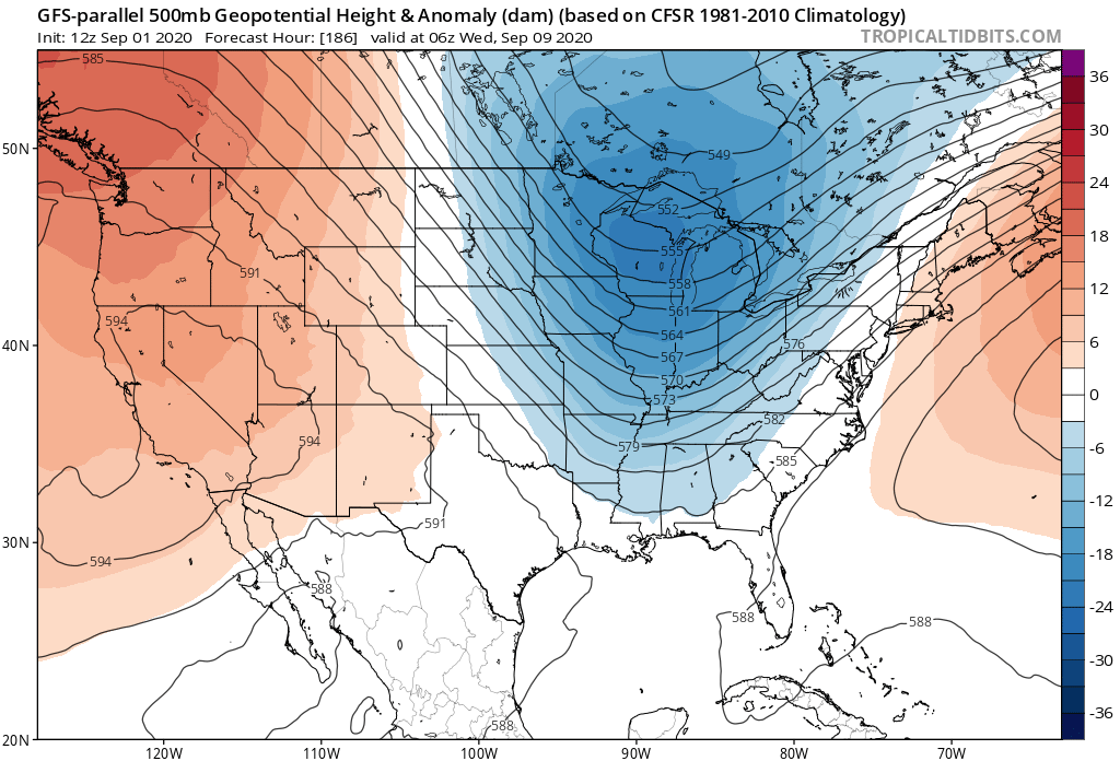
gatorcane wrote:The GFS parallel still shows the trough in the 12Z run:

https://i.postimg.cc/9FsmF9GN/gfsp-z500a-us-32.png


GEFS-Parallel has the trough slightly weaker and negative tilted west, slightly more east than the GEFS.

Image

GEPS agrees with the Euro of positioning it further west.

Image
0 likes   

TheStormExpert

Re: 2020 Global Model Runs Discussion (Out thru day 16)

#1840 Postby TheStormExpert » Tue Sep 01, 2020 4:08 pm

NDG wrote:Euro ensembles show potentially 2-3 systems at the same time over in the Atlantic basin during the peak of the season.

https://i.imgur.com/LSAtgYI.png

Besides the current two?
0 likes   


Return to “Talkin' Tropics”

Who is online

Users browsing this forum: cycloneye, dl20415, jhpigott, lolitx, sasha_B and 28 guests