2024 Global Model Runs Discussion (Out thru day 16)

This is the general tropical discussion area. Anyone can take their shot at predicting a storms path.

Moderator: S2k Moderators

Forum rules

The posts in this forum are NOT official forecasts and should not be used as such. They are just the opinion of the poster and may or may not be backed by sound meteorological data. They are NOT endorsed by any professional institution or STORM2K. For official information, please refer to products from the National Hurricane Center and National Weather Service.

Help Support Storm2K
Message
Author
User avatar
wxman57
Moderator-Pro Met
Moderator-Pro Met
Posts: 22979
Age: 67
Joined: Sat Jun 21, 2003 8:06 pm
Location: Houston, TX (southwest)

Re: 2024 Global Model Runs Discussion (Out thru day 16)

#1941 Postby wxman57 » Mon Sep 16, 2024 7:07 pm

LAF92 wrote:

I’m still learning alot of things weather wise. What does this map depict?


The blue over Florida indicates lower pressure aloft, hinting at a possible storm track toward the NE Gulf.
4 likes   

User avatar
jfk08c
S2K Supporter
S2K Supporter
Posts: 204
Joined: Mon Jun 11, 2018 4:36 pm
Location: Lakeland, FL

Re: 2024 Global Model Runs Discussion (Out thru day 16)

#1942 Postby jfk08c » Mon Sep 16, 2024 7:08 pm

LAF92 wrote:

I’m still learning alot of things weather wise. What does this map depict?


500mb height anomalies are the steering patterns for tropical systems.

Reds are high pressure ridges. Think of them like mountains. Storms cannot go through them, they have to go around them. If they cannot go around them, they will sometimes get blocked and stall.

Blues are low pressure troughs. Think of them like valleys. Storms tend to get pulled towards them and lifted off.

That's the basic ELI5 terminology that I learned
6 likes   

WeatherBoy2000
Category 1
Category 1
Posts: 346
Joined: Mon Apr 10, 2023 9:29 am

Re: 2024 Global Model Runs Discussion (Out thru day 16)

#1943 Postby WeatherBoy2000 » Mon Sep 16, 2024 7:08 pm

 https://x.com/flimpct/status/1835793354111459442


The last 10 days or so September might be a bit more interesting
0 likes   

User avatar
toad strangler
S2K Supporter
S2K Supporter
Posts: 4543
Joined: Sun Jul 28, 2013 3:09 pm
Location: Earth
Contact:

Re: 2024 Global Model Runs Discussion (Out thru day 16)

#1944 Postby toad strangler » Mon Sep 16, 2024 7:09 pm

That map shows the GEFS (ensembles) 500mb set up. This is the layer of atmosphere that has significant effect on steering of well developed tropical cyclones. This is too far out to take seriously at all. For now. But this specific map shows a weakness that would be a path of least resistance to a decently developed TC.
2 likes   

User avatar
Teban54
Category 5
Category 5
Posts: 3206
Joined: Sat May 19, 2018 1:19 pm

Re: 2024 Global Model Runs Discussion (Out thru day 16)

#1945 Postby Teban54 » Mon Sep 16, 2024 7:27 pm

I suppose that at this point, anything from "a disorganized mess that can't close off a circulation as it gets pulled north" to "a TS or Cat 1 landfalling in South Florida" to "a Cat 5 in the Gulf" is still on the table.
3 likes   

Hurricane Mike
Category 2
Category 2
Posts: 644
Joined: Tue Apr 10, 2018 7:44 am

Re: 2024 Global Model Runs Discussion (Out thru day 16)

#1946 Postby Hurricane Mike » Mon Sep 16, 2024 7:51 pm

The ensembles of both the GFS and EURO are showing two systems in the next week or so. One coming from the Southwest Caribbean, threatening the Yucatan, Cuba, Cayman Islands and Florida or the Gulf Coast, while another system forms off Africa.
0 likes   

User avatar
MetroMike
Category 4
Category 4
Posts: 952
Joined: Sun Aug 29, 2004 8:13 pm
Location: Tampa Bay
Contact:

Re: 2024 Global Model Runs Discussion (Out thru day 16)

#1947 Postby MetroMike » Mon Sep 16, 2024 9:15 pm

Hurricane Mike wrote:The ensembles of both the GFS and EURO are showing two systems in the next week or so. One coming from the Southwest Caribbean, threatening the Yucatan, Cuba, Cayman Islands and Florida or the Gulf Coast, while another system forms off Africa.


I've heard some pro mets saying the MDR is closed for the season. Gordon was an example of fail out there.
0 likes   

User avatar
SFLcane
S2K Supporter
S2K Supporter
Posts: 10163
Age: 47
Joined: Sat Jun 05, 2010 1:44 pm
Location: Lake Worth Florida

Re: 2024 Global Model Runs Discussion (Out thru day 16)

#1948 Postby SFLcane » Mon Sep 16, 2024 9:20 pm

0 likes   

User avatar
HurricaneBelle
S2K Supporter
S2K Supporter
Posts: 1179
Joined: Sun Aug 27, 2006 6:12 pm
Location: Clearwater, FL

Re: 2024 Global Model Runs Discussion (Out thru day 16)

#1949 Postby HurricaneBelle » Mon Sep 16, 2024 9:36 pm

The CAG was the setup for Idalia last year, albeit a month earlier in the season.
0 likes   

WeatherBoy2000
Category 1
Category 1
Posts: 346
Joined: Mon Apr 10, 2023 9:29 am

Re: 2024 Global Model Runs Discussion (Out thru day 16)

#1950 Postby WeatherBoy2000 » Mon Sep 16, 2024 10:00 pm

MetroMike wrote:
Hurricane Mike wrote:The ensembles of both the GFS and EURO are showing two systems in the next week or so. One coming from the Southwest Caribbean, threatening the Yucatan, Cuba, Cayman Islands and Florida or the Gulf Coast, while another system forms off Africa.


I've heard some pro mets saying the MDR is closed for the season. Gordon was an example of fail out there.


It isn't over until it's over, but late September will probably be the last opportunity for anything intense/long tracking to develop out there before climatology likely shuts things down for good.
0 likes   

User avatar
Cyclenall
Category 5
Category 5
Posts: 6666
Joined: Thu Jun 08, 2006 10:01 pm
Location: Ontario, Canada

Re: 2024 Global Model Runs Discussion (Out thru day 16)

#1951 Postby Cyclenall » Mon Sep 16, 2024 10:11 pm

There was no mention of the Euro 12z low that seems to spend forever east of the US coast. It may be subtropical or not at all as the precip is very broad later on sans 160 hrs in. It meanders south over 10 days. I love the run just for the constant ridging over me 8-) .
0 likes   

User avatar
MetroMike
Category 4
Category 4
Posts: 952
Joined: Sun Aug 29, 2004 8:13 pm
Location: Tampa Bay
Contact:

Re: 2024 Global Model Runs Discussion (Out thru day 16)

#1952 Postby MetroMike » Mon Sep 16, 2024 10:16 pm

HurricaneBelle wrote:The CAG was the setup for Idalia last year, albeit a month earlier in the season.


This was also the set-up for MH Ian 2 years ago last part of September.
0 likes   

User avatar
Teban54
Category 5
Category 5
Posts: 3206
Joined: Sat May 19, 2018 1:19 pm

Re: 2024 Global Model Runs Discussion (Out thru day 16)

#1953 Postby Teban54 » Mon Sep 16, 2024 10:51 pm

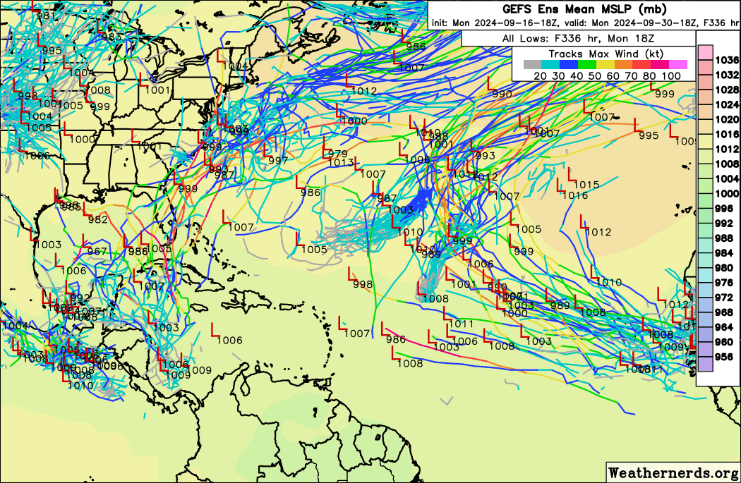
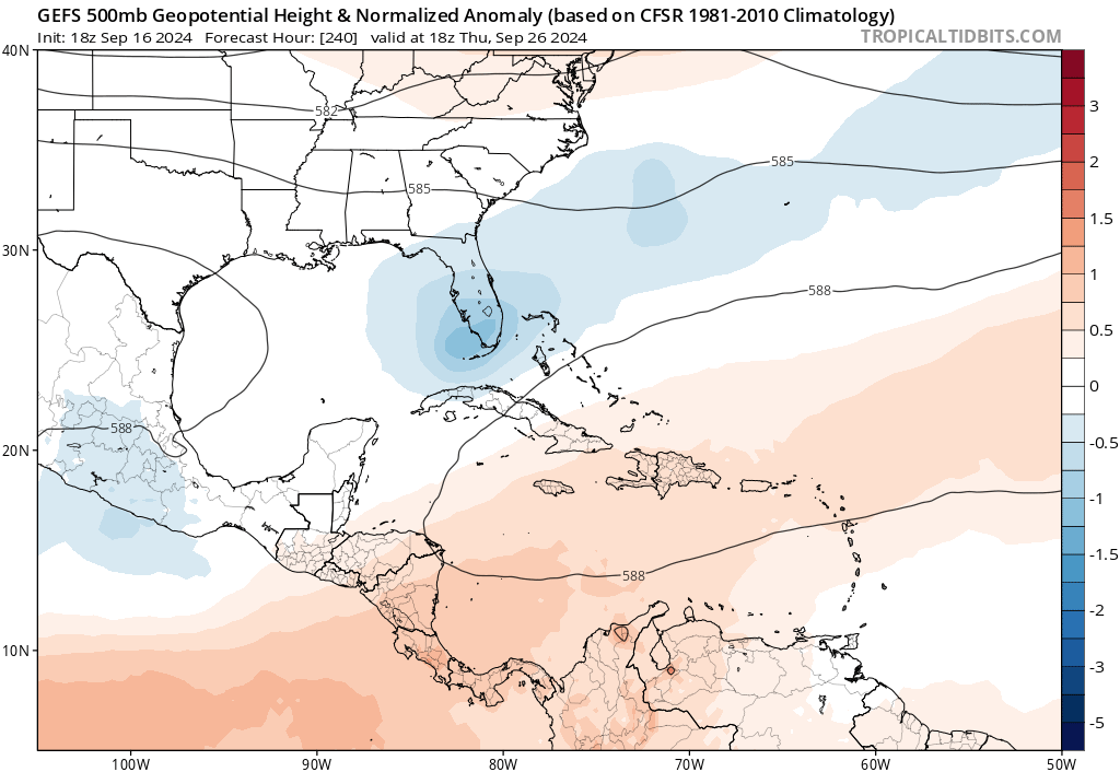
18z GEFS shows an uptick in MDR activity. As with earlier, there are signals for waves leaving Africa around 9/23 and 9/26. Recent runs seem to be showing a very slight trend of both having more members develop, and generally being a little bit stronger. The combined signal from both waves, if taken verbatim, may suggest that an Eastern Atlantic storm is even more likely than a Caribbean one.

Image

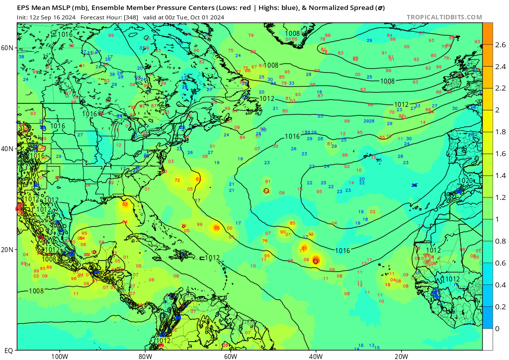
12z EPS also has a small uptick in the CV system, albeit not as much as GEFS. In the map below, most of the lows south of 30N in the open Atlantic are from the 9/26 wave.

Image
0 likes   

User avatar
SouthFLTropics
Category 5
Category 5
Posts: 4236
Age: 50
Joined: Thu Aug 14, 2003 8:04 am
Location: Port St. Lucie, Florida

Re: 2024 Global Model Runs Discussion (Out thru day 16)

#1954 Postby SouthFLTropics » Mon Sep 16, 2024 11:40 pm

Oh boy… 00z GFS coming in much stronger in the earlier part of the run for our Western Caribbean system. Further east also.


Sent from my iPhone using Tapatalk
0 likes   
Fourth Generation Florida Native

Personal Storm History: David 79, Andrew 92, Erin 95, Floyd 99, Irene 99, Frances 04, Jeanne 04, Wilma 05, Matthew 16, Irma 17, Ian 22, Nicole 22, Milton 24

User avatar
Teban54
Category 5
Category 5
Posts: 3206
Joined: Sat May 19, 2018 1:19 pm

Re: 2024 Global Model Runs Discussion (Out thru day 16)

#1955 Postby Teban54 » Mon Sep 16, 2024 11:44 pm

SouthFLTropics wrote:Oh boy… 00z GFS coming in much stronger in the earlier part of the run for our Western Caribbean system. Further east also.


Sent from my iPhone using Tapatalk

Just when you think it couldn't get stronger from the Happy Hour run... 955 mb right over Key West.
Image
1 likes   

Stratton23
Category 5
Category 5
Posts: 2520
Joined: Fri Jul 21, 2023 10:59 pm
Location: Katy, Tx

Re: 2024 Global Model Runs Discussion (Out thru day 16)

#1956 Postby Stratton23 » Mon Sep 16, 2024 11:45 pm

00z GFS and CMC have decently strong fronts which is why the “ system” gets tugged NE toward florida and eventually up the east coast
0 likes   

User avatar
SouthFLTropics
Category 5
Category 5
Posts: 4236
Age: 50
Joined: Thu Aug 14, 2003 8:04 am
Location: Port St. Lucie, Florida

Re: 2024 Global Model Runs Discussion (Out thru day 16)

#1957 Postby SouthFLTropics » Mon Sep 16, 2024 11:46 pm

Teban54 wrote:
SouthFLTropics wrote:Oh boy… 00z GFS coming in much stronger in the earlier part of the run for our Western Caribbean system. Further east also.


Sent from my iPhone using Tapatalk

Just when you think it couldn't get stronger from the Happy Hour run... 955 mb right over Key West.
https://i.postimg.cc/L6mn41LP/image.png

Looks like the sequel to Ian… making a run at Sanibel.


Sent from my iPhone using Tapatalk
0 likes   
Fourth Generation Florida Native

Personal Storm History: David 79, Andrew 92, Erin 95, Floyd 99, Irene 99, Frances 04, Jeanne 04, Wilma 05, Matthew 16, Irma 17, Ian 22, Nicole 22, Milton 24

User avatar
MetroMike
Category 4
Category 4
Posts: 952
Joined: Sun Aug 29, 2004 8:13 pm
Location: Tampa Bay
Contact:

Re: 2024 Global Model Runs Discussion (Out thru day 16)

#1958 Postby MetroMike » Mon Sep 16, 2024 11:46 pm

Thats an Ian like track, good thing its a ways out in time.
0 likes   

User avatar
Teban54
Category 5
Category 5
Posts: 3206
Joined: Sat May 19, 2018 1:19 pm

Re: 2024 Global Model Runs Discussion (Out thru day 16)

#1959 Postby Teban54 » Mon Sep 16, 2024 11:49 pm

Stratton23 wrote:00z GFS and CMC have decently strong fronts which is why the “ system” gets tugged NE toward florida and eventually up the east coast

Of course, right after GFS caved in to CMC's persistent solution of an Ian-like track (that CMC has been showing for 3-4 runs), 0z CMC shifted west immediately and now shows an Idalia track :lol:

The CMC track would also be the third hurricane landfall in Perry over 13 months.
0 likes   

User avatar
Teban54
Category 5
Category 5
Posts: 3206
Joined: Sat May 19, 2018 1:19 pm

Re: 2024 Global Model Runs Discussion (Out thru day 16)

#1960 Postby Teban54 » Tue Sep 17, 2024 12:21 am

Yeah, 0z GFS is the real Happy Hour, or perhaps Drunk Hour.

  • Gordon becomes stronger and peaks at 981 mb, which is the strongest that GFS had shown in a few days
  • The Caribbean system landfalls in Key West and Marco Island at 954 mb, crosses Lake Okeechobee, reintensifies after FL and landfalls in NC Outer Banks with the same pressure, before finally crashing into Long Island and New England
  • The 9/22 wave becomes a hurricane in the eastern MDR, reaching 968 mb when recurving at 40W (like Helene 2018) -- Edit: Looks like it's blocked by a ridge at the end of the run
  • (There's also a short-lived subtropical storm off the Carolinas coast at the same time when the two abovementioned storms are developing, but it might just be convective feedback)

Outside of GFS, though, 0z CMC has also shown development in the MDR for the first time in weeks (it didn't show Gordon until a TD had already formed). This run shows a TD/TS for both the 9/22 and the 9/26 waves.

Image
2 likes   


Return to “Talkin' Tropics”

Who is online

Users browsing this forum: jconsor, KeysRedWine, Ulf and 50 guests