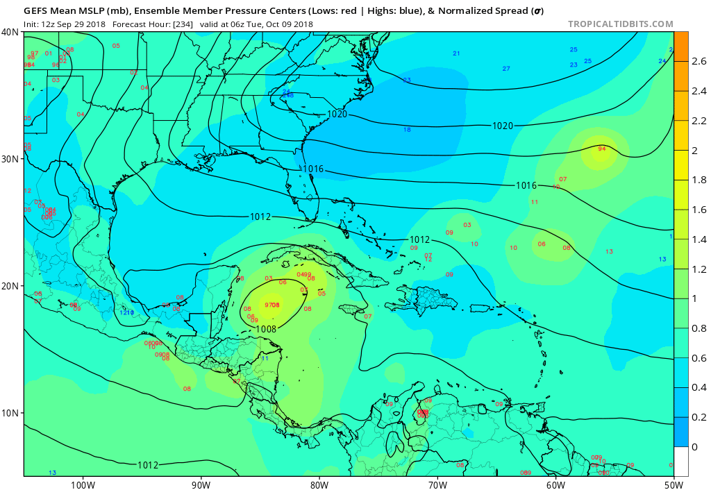
2018 Tropics: Global Model Runs Discussion (Out to day 16)

This is the general tropical discussion area. Anyone can take their shot at predicting a storms path.

Moderator: S2k Moderators

Forum rules

The posts in this forum are NOT official forecasts and should not be used as such. They are just the opinion of the poster and may or may not be backed by sound meteorological data. They are NOT endorsed by any professional institution or STORM2K. For official information, please refer to products from the National Hurricane Center and National Weather Service.

Help Support Storm2K
Message
Author
User avatar
chaser1
S2K Supporter
S2K Supporter
Posts: 5464
Age: 64
Joined: Sat Oct 15, 2005 5:59 pm
Location: Longwood, Fl

Re: 2018 Tropics: Global Model Runs Discussion (Out to day 16)

#1961 Postby chaser1 » Sat Sep 29, 2018 12:01 pm

toad strangler wrote:
chaser1 wrote:
NDG wrote:0z Euro ensembles, continuing to trend towards development in the western Caribbean in the 5-10 day range.

https://i.imgur.com/yCvIAge.gif


You just threw me a curve ball lol. I know the operational EURO only goes out to 240 hr., so where are you getting this depicting the EURO ensembles going out much further in time?


5-10 days ends at 240 hours......which I'm sure you know :D That's the timeframe he is talking about and what the graphic depicts


Nope... click the link itself and watch the time progression. It actually does go out to 326 hours (final verifying time being 0Z October 13)
1 likes   
Andy D

(For official information, please refer to the NHC and NWS products.)

User avatar
gatorcane
S2K Supporter
S2K Supporter
Posts: 23691
Age: 47
Joined: Sun Mar 13, 2005 3:54 pm
Location: Boca Raton, FL

Re: 2018 Tropics: Global Model Runs Discussion (Out to day 16)

#1962 Postby gatorcane » Sat Sep 29, 2018 12:03 pm

ICON going stronger:

Image
0 likes   

User avatar
toad strangler
S2K Supporter
S2K Supporter
Posts: 4543
Joined: Sun Jul 28, 2013 3:09 pm
Location: Earth
Contact:

Re: 2018 Tropics: Global Model Runs Discussion (Out to day 16)

#1963 Postby toad strangler » Sat Sep 29, 2018 12:06 pm

chaser1 wrote:
toad strangler wrote:
chaser1 wrote:
You just threw me a curve ball lol. I know the operational EURO only goes out to 240 hr., so where are you getting this depicting the EURO ensembles going out much further in time?


5-10 days ends at 240 hours......which I'm sure you know :D That's the timeframe he is talking about and what the graphic depicts


Nope... click the link itself and watch the time progression. It actually does go out to 326 hours (final verifying time being 0Z October 13)


Yep, I see it now. My bad.
0 likes   

User avatar
boca
Category 5
Category 5
Posts: 6367
Age: 60
Joined: Mon Dec 15, 2003 8:49 am
Location: Boca Raton,FL

Re: 2018 Tropics: Global Model Runs Discussion (Out to day 16)

#1964 Postby boca » Sat Sep 29, 2018 12:07 pm

Doesn’t look like it’s heading to Florida but going NNE
0 likes   

User avatar
toad strangler
S2K Supporter
S2K Supporter
Posts: 4543
Joined: Sun Jul 28, 2013 3:09 pm
Location: Earth
Contact:

Re: 2018 Tropics: Global Model Runs Discussion (Out to day 16)

#1965 Postby toad strangler » Sat Sep 29, 2018 12:08 pm

boca wrote:Doesn’t look like it’s heading to Florida but going NNE


Too far out for placement. Really right now it's all about the models coming together with consensus that their will be "something" coming out of the S to SW Caribbean.
Last edited by toad strangler on Sat Sep 29, 2018 12:09 pm, edited 1 time in total.
2 likes   

User avatar
NDG
S2K Supporter
S2K Supporter
Posts: 15446
Joined: Sun Jul 09, 2006 10:14 pm
Location: Orlando, FL

Re: 2018 Tropics: Global Model Runs Discussion (Out to day 16)

#1966 Postby NDG » Sat Sep 29, 2018 12:08 pm

chaser1 wrote:
toad strangler wrote:
chaser1 wrote:
You just threw me a curve ball lol. I know the operational EURO only goes out to 240 hr., so where are you getting this depicting the EURO ensembles going out much further in time?


5-10 days ends at 240 hours......which I'm sure you know :D That's the timeframe he is talking about and what the graphic depicts


Nope... click the link itself and watch the time progression. It actually does go out to 326 hours (final verifying time being 0Z October 13)


https://lab.weathermodels.com/models/ec ... clones.php
0 likes   

User avatar
toad strangler
S2K Supporter
S2K Supporter
Posts: 4543
Joined: Sun Jul 28, 2013 3:09 pm
Location: Earth
Contact:

Re: 2018 Tropics: Global Model Runs Discussion (Out to day 16)

#1967 Postby toad strangler » Sat Sep 29, 2018 12:12 pm

12z Canadian at 240. FWIW

Image
0 likes   

User avatar
NDG
S2K Supporter
S2K Supporter
Posts: 15446
Joined: Sun Jul 09, 2006 10:14 pm
Location: Orlando, FL

Re: 2018 Tropics: Global Model Runs Discussion (Out to day 16)

#1968 Postby NDG » Sat Sep 29, 2018 12:18 pm

12z GFS having its usual problems with a monsoonal vortex
0 likes   

User avatar
Hurricaneman
Category 5
Category 5
Posts: 7351
Age: 45
Joined: Tue Aug 31, 2004 3:24 pm
Location: central florida

Re: 2018 Tropics: Global Model Runs Discussion (Out to day 16)

#1969 Postby Hurricaneman » Sat Sep 29, 2018 12:38 pm

NDG wrote:12z GFS having its usual problems with a monsoonal vortex

Yep, spitting out 5 storms from the same area, looks like convective feedback, the Canadian looks sane in comparison
Last edited by Hurricaneman on Sat Sep 29, 2018 12:41 pm, edited 1 time in total.
0 likes   

User avatar
gatorcane
S2K Supporter
S2K Supporter
Posts: 23691
Age: 47
Joined: Sun Mar 13, 2005 3:54 pm
Location: Boca Raton, FL

Re: 2018 Tropics: Global Model Runs Discussion (Out to day 16)

#1970 Postby gatorcane » Sat Sep 29, 2018 12:40 pm

The 12Z GEFS with a noticeable increase in the number of members showing some development focused in the NW Caribbean:

Image
1 likes   

User avatar
Hurricaneman
Category 5
Category 5
Posts: 7351
Age: 45
Joined: Tue Aug 31, 2004 3:24 pm
Location: central florida

Re: 2018 Tropics: Global Model Runs Discussion (Out to day 16)

#1971 Postby Hurricaneman » Sat Sep 29, 2018 12:42 pm


I wouldn’t discount this solution
0 likes   

User avatar
chaser1
S2K Supporter
S2K Supporter
Posts: 5464
Age: 64
Joined: Sat Oct 15, 2005 5:59 pm
Location: Longwood, Fl

Re: 2018 Tropics: Global Model Runs Discussion (Out to day 16)

#1972 Postby chaser1 » Sat Sep 29, 2018 12:46 pm

:uarrow: Not only was the ICON even stronger on this run but extremely consistent track and location from last nights' 0Z to today's 12Z run as well. Today's 12Z GFS run is finally joining the over-all more western model camps (ICON, EURO, CMC, and EURO ensembles) depicting some level of development or lower pressures. Curious to see if the new FV3-GFS comes west this run as well but I am assuming it will. Up to now, ICON and CMC (along with a few of the EMS plots) show evolution of a tropical cyclone around 180 hours, while the GFS and EURO operational are distinctly further out in time. Will be interesting to see if either or both begin to start sniffing out earlier cyclogenesis and more in-line with the typically inferior models.
1 likes   
Andy D

(For official information, please refer to the NHC and NWS products.)

User avatar
Hurricaneman
Category 5
Category 5
Posts: 7351
Age: 45
Joined: Tue Aug 31, 2004 3:24 pm
Location: central florida

Re: 2018 Tropics: Global Model Runs Discussion (Out to day 16)

#1973 Postby Hurricaneman » Sat Sep 29, 2018 12:52 pm

chaser1 wrote::uarrow: Not only was the ICON even stronger on this run but extremely consistent track and location from last nights' 0Z to today's 12Z run as well. Today's 12Z GFS run is finally joining the over-all more western model camps (ICON, EURO, CMC, and EURO ensembles) depicting some level of development or lower pressures. Curious to see if the new FV3-GFS comes west this run as well but I am assuming it will. Up to now, ICON and CMC (along with a few of the EMS plots) show evolution of a tropical cyclone around 180 hours, while the GFS and EURO operational are distinctly further out in time. Will be interesting to see if either or both begin to start sniffing out earlier cyclogenesis and more in-line with the typically inferior models.

The test GFS is having a low forming near Hispaniola from convective feedback it seems, it’s nowhere near the 850 low and that IMO makes the GFS and it’s test model wrong based on spurious lows
0 likes   

User avatar
chaser1
S2K Supporter
S2K Supporter
Posts: 5464
Age: 64
Joined: Sat Oct 15, 2005 5:59 pm
Location: Longwood, Fl

Re: 2018 Tropics: Global Model Runs Discussion (Out to day 16)

#1974 Postby chaser1 » Sat Sep 29, 2018 12:54 pm

NDG wrote:
chaser1 wrote:
toad strangler wrote:

5-10 days ends at 240 hours......which I'm sure you know :D That's the timeframe he is talking about and what the graphic depicts


Nope... click the link itself and watch the time progression. It actually does go out to 326 hours (final verifying time being 0Z October 13)


https://lab.weathermodels.com/models/ec ... clones.php


Ah, thanks :wink: . Primary link took me there. Oddly, I can't seem to get the EPS spaghetti'os to loop but that's okay. At least I can click each 6 hr'ly chart
0 likes   
Andy D

(For official information, please refer to the NHC and NWS products.)

User avatar
chaser1
S2K Supporter
S2K Supporter
Posts: 5464
Age: 64
Joined: Sat Oct 15, 2005 5:59 pm
Location: Longwood, Fl

Re: 2018 Tropics: Global Model Runs Discussion (Out to day 16)

#1975 Postby chaser1 » Sat Sep 29, 2018 1:02 pm

Hurricaneman wrote:
chaser1 wrote::uarrow: Not only was the ICON even stronger on this run but extremely consistent track and location from last nights' 0Z to today's 12Z run as well. Today's 12Z GFS run is finally joining the over-all more western model camps (ICON, EURO, CMC, and EURO ensembles) depicting some level of development or lower pressures. Curious to see if the new FV3-GFS comes west this run as well but I am assuming it will. Up to now, ICON and CMC (along with a few of the EMS plots) show evolution of a tropical cyclone around 180 hours, while the GFS and EURO operational are distinctly further out in time. Will be interesting to see if either or both begin to start sniffing out earlier cyclogenesis and more in-line with the typically inferior models.

The test GFS is having a low forming near Hispaniola from convective feedback it seems, it’s nowhere near the 850 low and that IMO makes the GFS and it’s test model wrong based on spurious lows


Yep; America's newest and greatest answer to the EURO :roflmao: Maybe one day......
Oh well, give it 2 or 3 more runs and I suppose it'll catch up with the remaining models depicting W. Caribbean development (or at least lower pressures)
0 likes   
Andy D

(For official information, please refer to the NHC and NWS products.)

User avatar
chaser1
S2K Supporter
S2K Supporter
Posts: 5464
Age: 64
Joined: Sat Oct 15, 2005 5:59 pm
Location: Longwood, Fl

Re: 2018 Tropics: Global Model Runs Discussion (Out to day 16)

#1976 Postby chaser1 » Sat Sep 29, 2018 1:19 pm

gatorcane wrote:The 12Z GEFS with a noticeable increase in the number of members showing some development focused in the NW Caribbean:

https://i.postimg.cc/7L5PW6yr/gfs-ememb_lowlocs_watl_40.png


Not only a notable increase in GEFS members toward the W. Caribbean but a consolidation of members beginning at about 156 hours thus closer in line with ICON and CMC time frame of development. If this trend were to continue then I'd get the sense that the GFS operational might suddenly jump a good deal forward in time with cyclogenesis. On it's first run depicting W. Caribbean development (rather then a E. Caribbean solution), it's merely showing a stretched out 1004 low in the W. Caribbean at 288 hours which swiftly flies northeast and only deepens some when east of the Bahamas. We might begin to see the GFS depicting faster/lower pressures at the 180-192 hour range in subsequent runs to come. Keep in mind, an earlier developing (and deeper) system might well suggest less of a NNE departure out of the Caribbean as the current GFS depicts.
1 likes   
Andy D

(For official information, please refer to the NHC and NWS products.)

User avatar
Hurricaneman
Category 5
Category 5
Posts: 7351
Age: 45
Joined: Tue Aug 31, 2004 3:24 pm
Location: central florida

Re: 2018 Tropics: Global Model Runs Discussion (Out to day 16)

#1977 Postby Hurricaneman » Sat Sep 29, 2018 1:22 pm

chaser1 wrote:
gatorcane wrote:The 12Z GEFS with a noticeable increase in the number of members showing some development focused in the NW Caribbean:

https://i.postimg.cc/7L5PW6yr/gfs-ememb_lowlocs_watl_40.png


Not only a notable increase in GEFS members toward the W. Caribbean but a consolidation of members beginning at about 156 hours thus closer in line with ICON and CMC time frame of development. If this trend were to continue then I'd get the sense that the GFS operational might suddenly jump a good deal forward in time with cyclogenesis. On it's first run depicting W. Caribbean development (rather then a E. Caribbean solution), it's merely showing a stretched out 1004 low in the W. Caribbean at 288 hours which swiftly flies northeast and only deepens some when east of the Bahamas. We might begin to see the GFS depicting faster/lower pressures at the 180-192 hour range in subsequent runs to come. Keep in mind, an earlier developing (and deeper) system might well suggest less of a NNE departure out of the Caribbean as the current GFS depicts.

If this does what the models say though would it be Kirk or Michael or will we not know until next week
0 likes   

WeatherEmperor
S2K Supporter
S2K Supporter
Posts: 4806
Age: 41
Joined: Thu Sep 04, 2003 2:54 pm
Location: South Florida

Re: 2018 Tropics: Global Model Runs Discussion (Out to day 16)

#1978 Postby WeatherEmperor » Sat Sep 29, 2018 1:34 pm

12z JMA

Image


Sent from my iPhone using Tapatalk
0 likes   

User avatar
chaser1
S2K Supporter
S2K Supporter
Posts: 5464
Age: 64
Joined: Sat Oct 15, 2005 5:59 pm
Location: Longwood, Fl

Re: 2018 Tropics: Global Model Runs Discussion (Out to day 16)

#1979 Postby chaser1 » Sat Sep 29, 2018 1:49 pm

Hurricaneman wrote:
chaser1 wrote:
gatorcane wrote:The 12Z GEFS with a noticeable increase in the number of members showing some development focused in the NW Caribbean:

https://i.postimg.cc/7L5PW6yr/gfs-ememb_lowlocs_watl_40.png


Not only a notable increase in GEFS members toward the W. Caribbean but a consolidation of members beginning at about 156 hours thus closer in line with ICON and CMC time frame of development. If this trend were to continue then I'd get the sense that the GFS operational might suddenly jump a good deal forward in time with cyclogenesis. On it's first run depicting W. Caribbean development (rather then a E. Caribbean solution), it's merely showing a stretched out 1004 low in the W. Caribbean at 288 hours which swiftly flies northeast and only deepens some when east of the Bahamas. We might begin to see the GFS depicting faster/lower pressures at the 180-192 hour range in subsequent runs to come. Keep in mind, an earlier developing (and deeper) system might well suggest less of a NNE departure out of the Caribbean as the current GFS depicts.

If this does what the models say though would it be Kirk or Michael or will we not know until next week


Seems to me that this far out, there'd be no identifiable remnant of Kirk. Furthermore, as I was looking more closely at the GFS 500 vorticity from present analysis and outward from there, it became that much more evident to me that whatever development that may evolve out of the Western Caribbean appears to have origin from the ITCZ around Central America and appears to split off from a competing low attempting to develop on the other side.
0 likes   
Andy D

(For official information, please refer to the NHC and NWS products.)

TheStormExpert

Re: 2018 Tropics: Global Model Runs Discussion (Out to day 16)

#1980 Postby TheStormExpert » Sat Sep 29, 2018 1:50 pm

Model consensus seems to have trended west today. No surprise, considering that over the past few years that has been the normal trend in the Atlantic featuring a stronger Bermuda High.
0 likes   


Return to “Talkin' Tropics”

Who is online

Users browsing this forum: Google Adsense [Bot], hurricanes1234, IsabelaWeather and 33 guests