2018 Tropics: Global Model Runs Discussion (Out to day 16)
Moderator: S2k Moderators
Forum rules

The posts in this forum are NOT official forecasts and should not be used as such. They are just the opinion of the poster and may or may not be backed by sound meteorological data. They are NOT endorsed by any professional institution or STORM2K. For official information, please refer to products from the National Hurricane Center and National Weather Service.

Re: 2018 Tropics: Global Model Runs Discussion (Out to day 16)
216 hr EURO looking a more defined 1007 low just west of Jamaica then last night's run indicated. Also, there's some other subtle but obvious changes. Much stronger pressure gradient depicted over Florida and 500mb heights are distinctly higher then depicted on prior run. 240 hr. move's some small center due north into Cuba but no way to tell whether it was deepening further prior to landfall. Going further in time I'd guess a continued North to NNE motion would continue from there.
0 likes
Andy D
(For official information, please refer to the NHC and NWS products.)
(For official information, please refer to the NHC and NWS products.)
-
TheStormExpert

-
toad strangler

- S2K Supporter

- Posts: 4546
- Joined: Sun Jul 28, 2013 3:09 pm
- Location: Earth
- Contact:
Re: 2018 Tropics: Global Model Runs Discussion (Out to day 16)
Verbatim sure. But that's not what we are looking for 10 days out. Every model has lowering pressures in the same general area. A must watch for sure given Tis the Season for this area of the basin.
1 likes
My Weather Station
https://www.wunderground.com/dashboard/pws/KFLPORTS603
https://www.wunderground.com/dashboard/pws/KFLPORTS603
-
Hurricaneman

- Category 5

- Posts: 7404
- Age: 45
- Joined: Tue Aug 31, 2004 3:24 pm
- Location: central florida
Re: 2018 Tropics: Global Model Runs Discussion (Out to day 16)
There is a closed area over Cuba, that’s why no strengthening but if this is farther south then this would be a problem
0 likes
Re: 2018 Tropics: Global Model Runs Discussion (Out to day 16)
Take-away from today's early runs seem to point toward growing consensus of having a T.D. to low end T.S. in the N.W. Caribbean somewhere between 180-220 hr.'s. from now. Will be interesting to see if an increase in EURO EPS members suggest a deeper system then the operational model suggests.
1 likes
Andy D
(For official information, please refer to the NHC and NWS products.)
(For official information, please refer to the NHC and NWS products.)
-
toad strangler
- S2K Supporter
- Posts: 4546
- Joined: Sun Jul 28, 2013 3:09 pm
- Location: Earth
- Contact:
Re: 2018 Tropics: Global Model Runs Discussion (Out to day 16)
chaser1 wrote:Take-away from today's early runs seem to point toward growing consensus of having a T.D. to low end T.S. in the N.W. Caribbean somewhere between 180-220 hr.'s. from now. Will be interesting to see if an increase in EURO EPS members suggest a deeper system then the operational model suggests.
Would like to see 12z UKIE as well. I can only find previous 00z right now
0 likes
My Weather Station
https://www.wunderground.com/dashboard/pws/KFLPORTS603
https://www.wunderground.com/dashboard/pws/KFLPORTS603
-
SFLcane

- S2K Supporter
- Posts: 10281
- Age: 48
- Joined: Sat Jun 05, 2010 1:44 pm
- Location: Lake Worth Florida
Re: 2018 Tropics: Global Model Runs Discussion (Out to day 16)
So far 12z EPS is still fairly active..
0 likes
-
Hurricaneman
- Category 5
- Posts: 7404
- Age: 45
- Joined: Tue Aug 31, 2004 3:24 pm
- Location: central florida
Re: 2018 Tropics: Global Model Runs Discussion (Out to day 16)
SFLcane wrote:So far 12z EPS is still fairly active..
Look closer to the Yucatan channel overall
0 likes
-
SFLcane
- S2K Supporter
- Posts: 10281
- Age: 48
- Joined: Sat Jun 05, 2010 1:44 pm
- Location: Lake Worth Florida
Re: 2018 Tropics: Global Model Runs Discussion (Out to day 16)
Id say 12z EPS is more active the 00z with quite the concentration near the NW Caribbean. Some intense hurricanes there near SFL.
1 likes
Re: 2018 Tropics: Global Model Runs Discussion (Out to day 16)
SFLcane wrote:Id say 12z EPS is more active the 00z with quite the concentration near the NW Caribbean. Some intense hurricanes there near SFL.
The 12Z GEFS and EPS are both the most active of any run yet for Oct. They both suggest we have a break now but watch out 2nd wk in Oct entire Gulf coast. Time to check out climo for NW Car geneses ~10/5-8.
1 likes
Personal Forecast Disclaimer:
The posts in this forum are NOT official forecasts and should not be used as such. They are just the opinion of the poster and may or may not be backed by sound meteorological data. They are NOT endorsed by any professional institution or storm2k.org. For official information, please refer to the NHC and NWS products.
The posts in this forum are NOT official forecasts and should not be used as such. They are just the opinion of the poster and may or may not be backed by sound meteorological data. They are NOT endorsed by any professional institution or storm2k.org. For official information, please refer to the NHC and NWS products.
-
WeatherEmperor
- S2K Supporter
- Posts: 4806
- Age: 42
- Joined: Thu Sep 04, 2003 2:54 pm
- Location: South Florida
Re: 2018 Tropics: Global Model Runs Discussion (Out to day 16)
SFLcane wrote:Id say 12z EPS is more active the 00z with quite the concentration near the NW Caribbean. Some intense hurricanes there near SFL.
Can you post some images? I am on the road and dont have my bookmarks on my phone. Sorry about that
Sent from my iPhone using Tapatalk
0 likes
-
AnnularCane

- S2K Supporter
- Posts: 2959
- Joined: Thu Jun 08, 2006 9:18 am
- Location: Wytheville, VA
Re: 2018 Tropics: Global Model Runs Discussion (Out to day 16)
LarryWx wrote:SFLcane wrote:Id say 12z EPS is more active the 00z with quite the concentration near the NW Caribbean. Some intense hurricanes there near SFL.
The 12Z GEFS and EPS are both the most active of any run yet for Oct. They both suggest we have a break now but watch out 2nd wk in Oct entire Gulf coast. Time to check out climo for NW Car geneses ~10/5-8.
Last time the models said we'd have a break, we got Kirk and Leslie.
1 likes
Re: 2018 Tropics: Global Model Runs Discussion (Out to day 16)
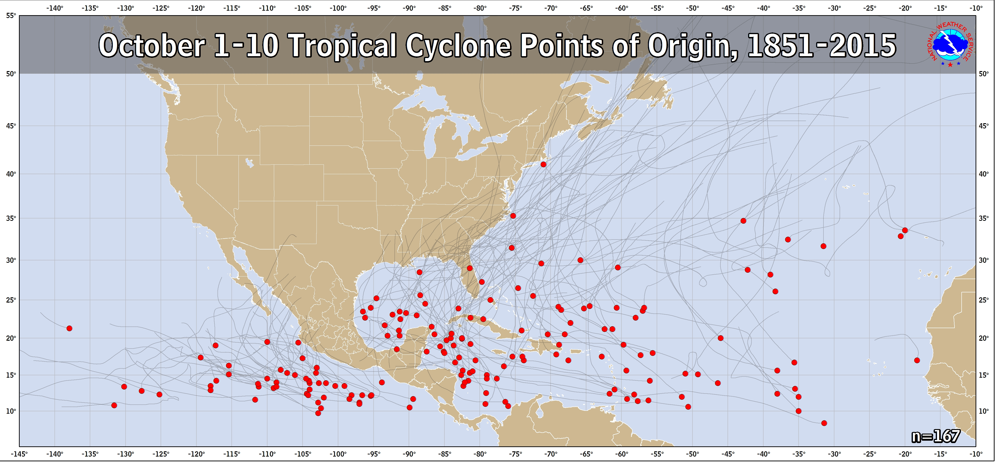
The 12Z GEFS and EPS are saying NW Car or SE/SC GOM genesis quite possible ~10/4-10. So, here is climo for Oct 1-10 1851-2015 geneses:
https://www.nhc.noaa.gov/climo/images/oct_1_10.png
Add Nate from 2017:
http://weather.unisys.com/hurricanes/2017/atlantic/nate
Conclusion per GEFS/EPS/climo: entire Gulf coast in play for 2nd wk oct hit from early Oct genesis but with more weighting FL/less TX
https://www.nhc.noaa.gov/climo/images/oct_1_10.png
Add Nate from 2017:
http://weather.unisys.com/hurricanes/2017/atlantic/nate
Conclusion per GEFS/EPS/climo: entire Gulf coast in play for 2nd wk oct hit from early Oct genesis but with more weighting FL/less TX
0 likes
Personal Forecast Disclaimer:
The posts in this forum are NOT official forecasts and should not be used as such. They are just the opinion of the poster and may or may not be backed by sound meteorological data. They are NOT endorsed by any professional institution or storm2k.org. For official information, please refer to the NHC and NWS products.
The posts in this forum are NOT official forecasts and should not be used as such. They are just the opinion of the poster and may or may not be backed by sound meteorological data. They are NOT endorsed by any professional institution or storm2k.org. For official information, please refer to the NHC and NWS products.
Re: 2018 Tropics: Global Model Runs Discussion (Out to day 16)
LarryWx wrote:The 12Z GEFS and EPS are saying NW Car or SE/SC GOM genesis quite possible ~10/4-10. So, here is climo for Oct 1-10 1851-2015 geneses:
https://www.nhc.noaa.gov/climo/images/oct_1_10.png
Add Nate from 2017:
http://weather.unisys.com/hurricanes/2017/atlantic/nate
Conclusion per GEFS/EPS/climo: entire Gulf coast in play for 2nd wk oct hit from early Oct genesis but with more weighting FL/less TX
What storm formed *over* Florida?
0 likes
-
Hurricaneman
- Category 5
- Posts: 7404
- Age: 45
- Joined: Tue Aug 31, 2004 3:24 pm
- Location: central florida
Re: 2018 Tropics: Global Model Runs Discussion (Out to day 16)
mlfreeman wrote:LarryWx wrote:The 12Z GEFS and EPS are saying NW Car or SE/SC GOM genesis quite possible ~10/4-10. So, here is climo for Oct 1-10 1851-2015 geneses:
https://www.nhc.noaa.gov/climo/images/oct_1_10.png
Add Nate from 2017:
http://weather.unisys.com/hurricanes/2017/atlantic/nate
Conclusion per GEFS/EPS/climo: entire Gulf coast in play for 2nd wk oct hit from early Oct genesis but with more weighting FL/less TX
What storm formed *over* Florida?
He’s not saying anything is going to form over Florida, it’s more like Florida is a likely destination
0 likes
-
AutoPenalti
- Category 5
- Posts: 4091
- Age: 29
- Joined: Mon Aug 17, 2015 4:16 pm
- Location: Ft. Lauderdale, Florida
Re: 2018 Tropics: Global Model Runs Discussion (Out to day 16)
Hurricaneman wrote:mlfreeman wrote:LarryWx wrote:The 12Z GEFS and EPS are saying NW Car or SE/SC GOM genesis quite possible ~10/4-10. So, here is climo for Oct 1-10 1851-2015 geneses:
https://www.nhc.noaa.gov/climo/images/oct_1_10.png
Add Nate from 2017:
http://weather.unisys.com/hurricanes/2017/atlantic/nate
Conclusion per GEFS/EPS/climo: entire Gulf coast in play for 2nd wk oct hit from early Oct genesis but with more weighting FL/less TX
What storm formed *over* Florida?
He’s not saying anything is going to form over Florida, it’s more like Florida is a likely destination
I think he's asking what storm formed over Florida...
0 likes
The posts in this forum are NOT official forecasts and should not be used as such. They are just the opinion of the poster and may or may not be backed by sound meteorological data. They are NOT endorsed by any professional institution or STORM2K. For official information, please refer to products from the NHC and NWS.
Model Runs Cheat Sheet:
GFS (5:30 AM/PM, 11:30 AM/PM)
HWRF, GFDL, UKMET, NAVGEM (6:30-8:00 AM/PM, 12:30-2:00 AM/PM)
ECMWF (1:45 AM/PM)
TCVN is a weighted averaged
Re: 2018 Tropics: Global Model Runs Discussion (Out to day 16)
AutoPenalti wrote:Hurricaneman wrote:mlfreeman wrote:
What storm formed *over* Florida?
He’s not saying anything is going to form over Florida, it’s more like Florida is a likely destination
I think he's asking what storm formed over Florida...
Yes, there's one red dot over Florida on the first image.
I'm assuming red dots = where storms were formed.
I'm curious which storm that was, if anyone can tell somehow.
0 likes


-
Hurricaneman
- Category 5
- Posts: 7404
- Age: 45
- Joined: Tue Aug 31, 2004 3:24 pm
- Location: central florida
Re: 2018 Tropics: Global Model Runs Discussion (Out to day 16)
The 18zGFS shows a convective feedback system going up the east coast while the system the other models show is forming after truncation so we may have to wait a few days for the GFS catches on
0 likes
-
toad strangler
- S2K Supporter
- Posts: 4546
- Joined: Sun Jul 28, 2013 3:09 pm
- Location: Earth
- Contact:
Re: 2018 Tropics: Global Model Runs Discussion (Out to day 16)
12z UKMET was slower at 168 hours and in the deep SW Caribbean

0 likes
My Weather Station
https://www.wunderground.com/dashboard/pws/KFLPORTS603
https://www.wunderground.com/dashboard/pws/KFLPORTS603
Who is online
Users browsing this forum: tolakram and 33 guests