2020 Global Model Runs Discussion (Out thru day 16)
Moderator: S2k Moderators
Forum rules

The posts in this forum are NOT official forecasts and should not be used as such. They are just the opinion of the poster and may or may not be backed by sound meteorological data. They are NOT endorsed by any professional institution or STORM2K. For official information, please refer to products from the National Hurricane Center and National Weather Service.
-
gatorcane

- S2K Supporter

- Posts: 23708
- Age: 48
- Joined: Sun Mar 13, 2005 3:54 pm
- Location: Boca Raton, FL
Re: 2020 Global Model Runs Discussion (Out thru day 16)
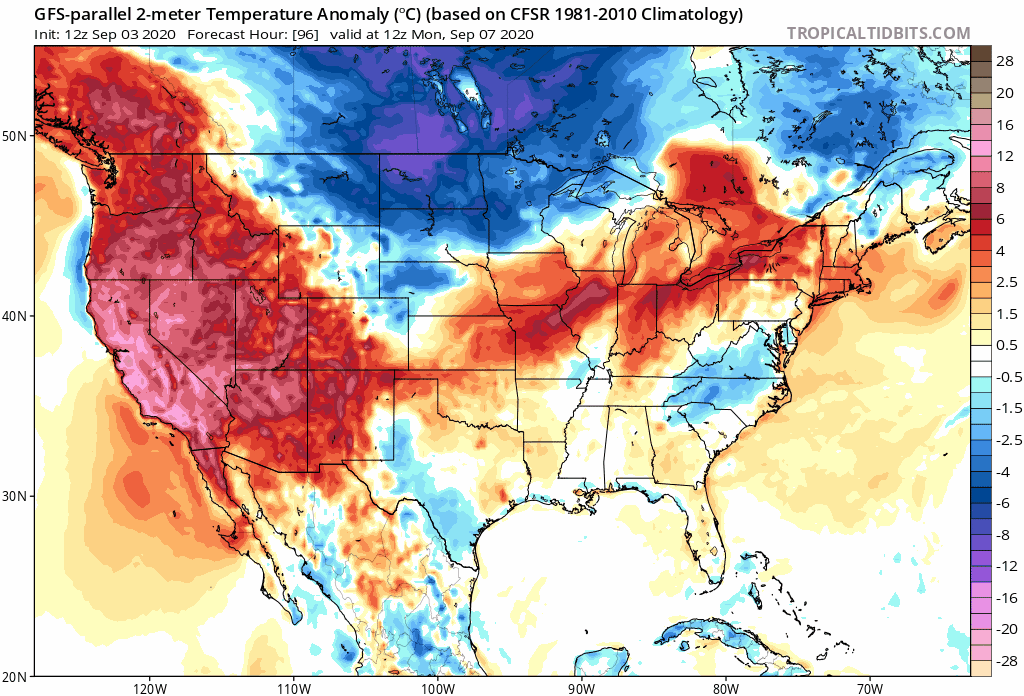
The GFS para and GFS models continue to bring an impressive cold front all the way down to the northern Gulf. The below normal temps stick around for a while which would put a big dent into SSTs:
2 likes
Re: 2020 Global Model Runs Discussion (Out thru day 16)
gatorcane wrote:The GFS para and GFS models continue to bring an impressive cold front all the way down to the northern Gulf. The below normal temps stick around for a while which would put a big dent into SSTs:
https://i.postimg.cc/fLfpS3J9/gfsp-T2ma-us-fh96-240.gif
From NWS New Orleans:
Moving into the middle of next week, the GFS still suggests a much
more potent trough will swing through and bring a strong cold front
through. The ECMWF`s solution is still a bit more typical
climatologically with the Bermuda Ridge still holding
strong. The previous run of the GFS showed a solution closer to the
ECMWF. Tend to think the most realistic occurrence will be similar to
the ECMWF.
8 likes

Re: 2020 Global Model Runs Discussion (Out thru day 16)
Yeah. Even if the GFS was right, sunny and mild would have no considerable effect on the Gulf. It takes cyclones or prolonged, heavy rainfall to dent the Gulf this early in September. What’s odd about it is the trough piece it leaves behind and possibly cuts off does lead to a ton of rain across the Gulf.
1 likes
Re: 2020 Global Model Runs Discussion (Out thru day 16)
Steve wrote:Yeah. Even if the GFS was right, sunny and mild would have no considerable effect on the Gulf. It takes cyclones or prolonged, heavy rainfall to dent the Gulf this early in September. What’s odd about it is the trough piece it leaves behind and possibly cuts off does lead to a ton of rain across the Gulf.
From my experience of following the SE coast, significantly colder temps from one cold front like this will have a pretty appreciable cooling effect on SSTs if they are quite a bit warmer than the daily mean temps behind the front but mainly only within 50 or so miles of the coast because the cold air usually modifies so quickly once away from the coast. Furthermore, IF much warmer air soon follows in Sept (which is common this early in the month), those coastal waters will then warm back up to some extent pretty quickly.
1 likes
Personal Forecast Disclaimer:
The posts in this forum are NOT official forecasts and should not be used as such. They are just the opinion of the poster and may or may not be backed by sound meteorological data. They are NOT endorsed by any professional institution or storm2k.org. For official information, please refer to the NHC and NWS products.
The posts in this forum are NOT official forecasts and should not be used as such. They are just the opinion of the poster and may or may not be backed by sound meteorological data. They are NOT endorsed by any professional institution or storm2k.org. For official information, please refer to the NHC and NWS products.

Re: 2020 Global Model Runs Discussion (Out thru day 16)
gatorcane wrote:The GFS para and GFS models continue to bring an impressive cold front all the way down to the northern Gulf. The below normal temps stick around for a while which would put a big dent into SSTs:
https://i.postimg.cc/fLfpS3J9/gfsp-T2ma-us-fh96-240.gif
Yes, its 12z & 18z runs went back to yesterday's runs but its ensembles' is still not so aggressive with its core not progressing much eastward.

Last edited by NDG on Thu Sep 03, 2020 10:09 pm, edited 1 time in total.
0 likes
Re: 2020 Global Model Runs Discussion (Out thru day 16)
LarryWx wrote:Because nobody is really talking about this much, here's the 18Z ICON, which is still another run with a very weak sfc low off the SE coast that is only crawling N here. All ICON runs since 0Z have had something similar and today's 2 Euro runs also had something vaguely similar. Something worth monitoring. Also, watch that low in the
Gulf. Ridge over troubled waters pattern:
https://i.imgur.com/5nElB3l.png
I have been talking about this since last night, it is also part from the TW that has entered the eastern Caribbean.
2 likes


Re: 2020 Global Model Runs Discussion (Out thru day 16)
gatorcane wrote:The GFS para and GFS models continue to bring an impressive cold front all the way down to the northern Gulf. The below normal temps stick around for a while which would put a big dent into SSTs:
https://i.postimg.cc/fLfpS3J9/gfsp-T2ma-us-fh96-240.gif
That would be great, but local mets are not in line with this scenario.
1 likes
Not a professional forecast by any means.
Audrey'57, Hilda'64, Betsy '65, Edith'71, Carmen'74, Danny'85, Juan'85, Andrew'92, Iniki'92 (while on vacation in Kauai), Lili'02, Rita'05, Humberto'07, Gustav'08, Ike'08, Isaac'12, Monsoonal Depression'16, Harvey'17, Barry'19, Laura'20, Delta'20, Ida'21.
Audrey'57, Hilda'64, Betsy '65, Edith'71, Carmen'74, Danny'85, Juan'85, Andrew'92, Iniki'92 (while on vacation in Kauai), Lili'02, Rita'05, Humberto'07, Gustav'08, Ike'08, Isaac'12, Monsoonal Depression'16, Harvey'17, Barry'19, Laura'20, Delta'20, Ida'21.
Re: 2020 Global Model Runs Discussion (Out thru day 16)
LarryWx wrote:Steve wrote:Yeah. Even if the GFS was right, sunny and mild would have no considerable effect on the Gulf. It takes cyclones or prolonged, heavy rainfall to dent the Gulf this early in September. What’s odd about it is the trough piece it leaves behind and possibly cuts off does lead to a ton of rain across the Gulf.
From my experience of following the SE coast, significantly colder temps from one cold front like this will have a pretty appreciable cooling effect on SSTs if they are quite a bit warmer than the daily mean temps behind the front but mainly only within 50 or so miles of the coast because the cold air usually modifies so quickly once away from the coast. Furthermore, IF much warmer air soon follows in Sept (which is common this early in the month), those coastal waters will then warm back up to some extent pretty quickly.
It’s been hot and sunny since the tail from Laura pulled out. Gulf has a little shadow, and I’m sure it’s cooled subsurface. But it doesn’t take much to get it back which was my point. Absent a tropical system, it’s got to rain. A dry trough bringing sunny skies and cooler temps for a few days won’t matter yet for the Gulf. Generally we’re talking a couple degrees max which would rebound. What I don’t like about that trough is you don’t even have to guess what’s coming when you see that kind of amplification.
4 likes

Re: 2020 Global Model Runs Discussion (Out thru day 16)
GFS is forecasting snow in the TX Panhandle.

0 likes


Re: 2020 Global Model Runs Discussion (Out thru day 16)
GFS spins up a deep warm core on Tues in the mid MDR.
Appears to be high up off the ITCZ.
Not seeing any other models on it yet.

Appears to be high up off the ITCZ.
Not seeing any other models on it yet.
0 likes
Re: 2020 Global Model Runs Discussion (Out thru day 16)
Actually, ICON has it 102 hrs out as well 15N 45W
Much different track than GFS though.

Much different track than GFS though.
0 likes

Re: 2020 Global Model Runs Discussion (Out thru day 16)
Darvince wrote::lol:
? You decide!
3 Major Hurricanes at the same time a massive cold front hits the south causing snow in of all places Texas?!?!?
What...
The...
F#@$...!
This is literally the setup for The Day After Tomorrow!!!
It’s official...GFS

6 likes

Re: 2020 Global Model Runs Discussion (Out thru day 16)
ClarCari wrote:
3 Major Hurricanes at the same time a massive cold front hits the south causing snow in of all places Texas?!?!?
What...
The...
F#@$...!
This is literally the setup for The Day After Tomorrow!!!
It’s official...GFS
I think GFS OP is showing the snow vs GFS next gen above--either way both of these seem completely insane.
3 likes
The above post is not official and should not be used as such. It is the opinion of the poster and may or may not be backed by sound meteorological data. It is not endorsed by any professional institution or storm2k.org. For official information, please refer to the NHC and NWS products.
-
SconnieCane
- Category 5

- Posts: 1013
- Joined: Thu Aug 02, 2018 5:29 pm
- Location: Madison, WI
Re: 2020 Global Model Runs Discussion (Out thru day 16)
ClarCari wrote:
3 Major Hurricanes at the same time a massive cold front hits the south causing snow in of all places Texas?!?!?
What...
The...
F#@$...!
This is literally the setup for The Day After Tomorrow!!!
It’s official...GFS
This is the parallel GFS, on which the cold surge is more subdued than on the OP and has abated for over a week by the time the "triplets" image is valid.
0 likes
Re: 2020 Global Model Runs Discussion (Out thru day 16)
SconnieCane wrote:ClarCari wrote:
3 Major Hurricanes at the same time a massive cold front hits the south causing snow in of all places Texas?!?!?
What...
The...
F#@$...!
This is literally the setup for The Day After Tomorrow!!!
It’s official...GFS
This is the parallel GFS, on which the cold surge is more subdued than on the OP and has abated for over a week by the time the "triplets" image is valid.
No I get that.
My point is just that the GFS in general is spitting out ballsy model scenarios that look straight out of a doomsday movie
1 likes
Re: 2020 Global Model Runs Discussion (Out thru day 16)
I think it was early this week I saw this as a polar-vortex driven Rossby Wave.
What's interesting as how this may settle out mid to late next week.
A slight chance something may happen in the W GoM / BoC area.
What's interesting as how this may settle out mid to late next week.
A slight chance something may happen in the W GoM / BoC area.
0 likes
-
SFLcane

- S2K Supporter
- Posts: 10281
- Age: 48
- Joined: Sat Jun 05, 2010 1:44 pm
- Location: Lake Worth Florida
Re: 2020 Global Model Runs Discussion (Out thru day 16)
This next wave long range could get a little more interesting as the ridge tries to build In but I suspect it will eventually find a route north to.
0 likes
-
SFLcane
- S2K Supporter
- Posts: 10281
- Age: 48
- Joined: Sat Jun 05, 2010 1:44 pm
- Location: Lake Worth Florida
Re: 2020 Global Model Runs Discussion (Out thru day 16)
Then of course there is Para not very realistic to me Based on ensembles.
1 likes

Re: 2020 Global Model Runs Discussion (Out thru day 16)
06z GFS has 91L/Wave 2 and Wave 3 quickly evolve within the next 3-4 days. 91L and Wave 2 quickly merge together, and Wave 3 attempts to develop not long after exiting the coast of Africa.


The super long-range fantasy land time frame of that run also shows a couple other systems, including a low-riding MDR hurricane probably en route to become a Caribbean Cruiser. The fact that the GFS is now showing development everywhere, after having to be force-fed TCs all season, is yet another indicator that the rest of September will be exceptionally active.

Meanwhile, the 00z Euro has a Cat 3 heading due west in the MDR. This is from Wave 4, which should exit the African coast mid to late next week.

The super long-range fantasy land time frame of that run also shows a couple other systems, including a low-riding MDR hurricane probably en route to become a Caribbean Cruiser. The fact that the GFS is now showing development everywhere, after having to be force-fed TCs all season, is yet another indicator that the rest of September will be exceptionally active.
Meanwhile, the 00z Euro has a Cat 3 heading due west in the MDR. This is from Wave 4, which should exit the African coast mid to late next week.
6 likes
Irene '11 Sandy '12 Hermine '16 5/15/2018 Derecho Fay '20 Isaias '20 Elsa '21 Henri '21 Ida '21
I am only a meteorology enthusiast who knows a decent amount about tropical cyclones. Look to the professional mets, the NHC, or your local weather office for the best information.
I am only a meteorology enthusiast who knows a decent amount about tropical cyclones. Look to the professional mets, the NHC, or your local weather office for the best information.
Who is online
Users browsing this forum: No registered users and 363 guests