Typhoon Tip Satellite Image
Moderator: S2k Moderators
Forum rules

The posts in this forum are NOT official forecasts and should not be used as such. They are just the opinion of the poster and may or may not be backed by sound meteorological data. They are NOT endorsed by any professional institution or STORM2K. For official information, please refer to products from the National Hurricane Center and National Weather Service.
-
HurricaneBill
- Category 5

- Posts: 3419
- Joined: Sun Apr 11, 2004 5:51 pm
- Location: East Longmeadow, MA, USA
Re: Typhoon Tip Satellite Image
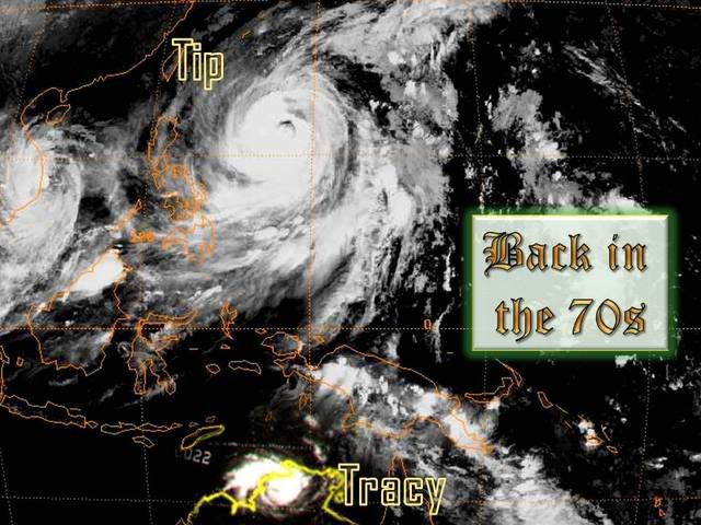
Somebody should find a way to photoshop Cyclone Tracy into one of the Tip images.

0 likes
-
whereverwx
- Category 5
- Posts: 1107
- Joined: Mon May 31, 2004 10:15 pm
Re: Typhoon Tip Satellite Image
HurricaneBill wrote:Somebody should find a way to photoshop Cyclone Tracy into one of the Tip images.
Image
I hope this works:
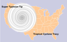
Image
Last edited by whereverwx on Wed Jul 30, 2008 7:53 pm, edited 1 time in total.
0 likes

-
Matt-hurricanewatcher
Re: Typhoon Tip Satellite Image
What a let down Tips appears to be. I always thought that if it was in the Atlatnic, it would cover a much larger area, but I guest it was only slightly bigger then Katrina and Wilma. There has got to be bigger for the Western Pacific.
0 likes

Re: Typhoon Tip Satellite Image
Matt-hurricanewatcher wrote:What a let down Tips appears to be. I always thought that if it was in the Atlatnic, it would cover a much larger area, but I guest it was only slightly bigger then Katrina and Wilma. There has got to be bigger for the Western Pacific.
I agree. I'm actually a bit dissapointed by not only the size of Tip, but by also the size of Tracy. I think that this representation of both cyclones is not accurate...
0 likes
-
HURAKAN

- Professional-Met

- Posts: 46084
- Age: 39
- Joined: Thu May 20, 2004 4:34 pm
- Location: Key West, FL
- Contact:
It seems that what made Tip so incredible was not the size of the storm, but the extend of the winds.
5. Which are the largest and smallest tropical cyclones on record?
Source: http://www.prh.noaa.gov/cphc/pages/FAQ/ ... ecords.php
Typhoon Tip had gale force winds (17 m/s [34 kt, 39 mph]) which extended out for 1100 km [675 mi]in radius in the Northwest Pacific on 12 October, 1979 (Dunnavan and Diercks 1980). Tropical Cyclone Tracy had gale force winds that only extended 50 km [30 mi] radius when it struck Darwin, Australia, on 24 December, 1974 (Bureau of Meteorology 1977).
0 likes
-
Matt-hurricanewatcher
Re: Typhoon Tip Satellite Image
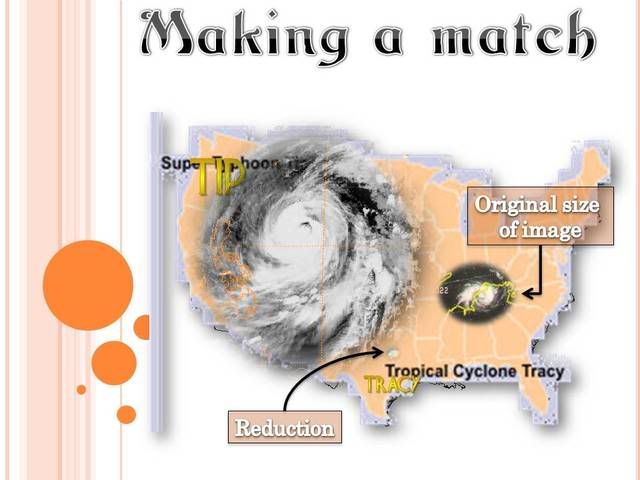
http://www.ncdc.noaa.gov/oa/rsad/gibbs/ ... html#image
Wilma was not much smaller then Tips on the 'same' area you placed TIPs on that Image. I almost dare to say that Wilma looked badder with its -90c cloud tops.
Hell, I almost say that Wilma, at least on that image was the same size. Tips almost got dethorned.
Wilma was not much smaller then Tips on the 'same' area you placed TIPs on that Image. I almost dare to say that Wilma looked badder with its -90c cloud tops.
Hell, I almost say that Wilma, at least on that image was the same size. Tips almost got dethorned.
0 likes
-
Matt-hurricanewatcher
Re: Typhoon Tip Satellite Image
http://www.ncdc.noaa.gov/oa/rsad/gibbs/ ... 12-ir.html
I look at this image of Wilma, and all I can say is that she deserves to be listed near Tips for size.
I look at this image of Wilma, and all I can say is that she deserves to be listed near Tips for size.
0 likes
-
Derek Ortt

Re:
Derek Ortt wrote:matt... please
a TC size is defined by wind field not cloud field. To say Tip was a letdown is absurred, IMO. Wilma was about 60% of Tip's size... meaning, Tip was nearly twice as large as Wilma
So the cloud field of Wilma was larger then Tip?
0 likes

-
Derek Ortt
-
Derek Ortt
-
MiamiensisWx
Re: Typhoon Tip Satellite Image
Personally, Tip's circulation still looks much larger than Wilma to me. The circulation of Tip essentially covers the entire image in Cyclone1's post. Although the comparison shows Wilma at peak intensity in the Caribbean, I doubt Wilma's circulation east of FL matched Tip. I will admit that Tracy's circulation may be slightly larger than some reports, but the image comparison with Tip removes anyone's doubts that it was a midget TC. It is small as it looks, and its wind radii was definitely exceptionally compact...
0 likes
Who is online
Users browsing this forum: bird and 251 guests