CIMMS steering suggests a circulation between 850 and 700 mb with the blog crossing Tehuanepec from the Pacific, so things could get interesting. Interestingly enough, CIMMS mean level steering for a number of intervals (corresponding to cyclones of various strengths), would seem to suggest that blob should be stationary or drifting to the Southwest, due flow between ridge over Texas and Eastern trough.
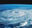
Lower level (weaker system) steering showing circulation.

Instead of the front itself being a trigger, the front may just disrupt the normal onshore flow into Texas/Mexico, that usually minimizes surface convergence, and the actual trigger may be a feature from the tropics.
Some low level convergence, upper divergence, and upper anticyclonic flow, per CIMMS, but the anticyclone is in the extreme deep BOC, and shear rapidly becomes hostile North of about 23ºN
 0Z WRF 500 mb forecast
 suggests that Eastern trough retrogrades somewhat, and steering in the Southwest Gulf eventually turns more from the West in the next three days, so anything that does/could form, might tend to head in the general direction of Florida.
Unofficial, just my amateur opinion.


