Disturbed weather in the SW Caribbean (Is invest 93L)
Moderator: S2k Moderators
Forum rules
The posts in this forum are NOT official forecasts and should not be used as such. They are just the opinion of the poster and may or may not be backed by sound meteorological data. They are NOT endorsed by any professional institution or STORM2K. For official information, please refer to products from the National Hurricane Center and National Weather Service.
Re: GFS/Euro Long-Range Show a Tropical Cyclone in SW Caribbean
I think there's a LOW down over Panama but it is EPAC centered:


0 likes
- gatorcane
- S2K Supporter

- Posts: 23708
- Age: 48
- Joined: Sun Mar 13, 2005 3:54 pm
- Location: Boca Raton, FL
Okay 12Z GFS hot off the press and now it shows this tropical cyclone meandering around the SW Caribbean drifting North and then it takes a turn to the NW into the NW Caribbean/Yucatan channel. The previous run moved this cyclone quickly NE through Eastern Cuba and the Bahamas out ahead of an approaching front.
Note it forms this low only 3-4 days from now, so the likelyhood some kind of low pressure developing in the SW Caribbean has increased.
The Low forms in 72 hours (just 3 days from now) in the SW Caribbean:
http://www.nco.ncep.noaa.gov/pmb/nwprod ... n_072m.gif
At 204 hours (day 9) it really starts to deepen:
http://www.nco.ncep.noaa.gov/pmb/nwprod ... n_204m.gif
Then at 384 hours its located just south of the Yucatan channel:
http://www.nco.ncep.noaa.gov/pmb/nwprod ... n_384m.gif
Note the big front digging through the Central US at 384 hours. The cyclone would likely turn NE in response to this front.
0 likes
- gatorcane
- S2K Supporter

- Posts: 23708
- Age: 48
- Joined: Sun Mar 13, 2005 3:54 pm
- Location: Boca Raton, FL
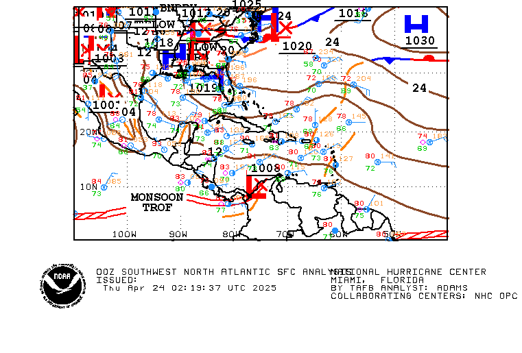
Here is a current surface plot. Note the front draped across the SW Caribbean pushing southeastward -- unusual for October I have to admit (what a powerful front). But also note the tropical waves heading west from the Eastern Caribbean. When these waves meet up with this dangling front that is what could provide the spark that the GFS insists will start the formation of a low and eventually tropical cyclone in the SW Caribbean.


0 likes
- Tampa Bay Hurricane
- Category 5

- Posts: 5597
- Age: 38
- Joined: Fri Jul 22, 2005 7:54 pm
- Location: St. Petersburg, FL
- gatorcane
- S2K Supporter

- Posts: 23708
- Age: 48
- Joined: Sun Mar 13, 2005 3:54 pm
- Location: Boca Raton, FL
Re:
Tampa Bay Hurricane wrote:In the very south part of the Caribbean the convection looks impressive.
It feels like winter in Florida, but then again this system is 600 miles
south of Florida at least.
After this front, none are expected for a while so don't get too used to it
Check out NOGAPS 12Z:

and look at the UKM (United Kingdom model):

0 likes
- Blown Away
- S2K Supporter

- Posts: 10253
- Joined: Wed May 26, 2004 6:17 am
-
MiamiensisWx
Re: GFS/Euro Long-Range Show a Tropical Cyclone in SW Caribbean
bvigal wrote:Why I won't laugh at this... I know the odds are slim, but down here we might be construed as superstitious about declaring "it's over", even this late. And we do pay attention to the western Caribbean. Here's why.
You're not "superstitious" - you're merely adhering to common sense. It is a fallacy that the season is "over" for other (non-CONUS) locations after October 25. There have been numerous Caribbean TCs (including Lenny, Michelle, 1932 #10, etc.) after October 25; the majority of the systems did not affect the mainland United States, but they did impact the Antilles, Central America, and other locales fringing the Caribbean Sea. You're vigilant, and it's warranted... the odds (contrary to some beliefs) are not as "slim" for non-mainland locations after October 25!
Last edited by MiamiensisWx on Wed Oct 29, 2008 2:35 pm, edited 1 time in total.
0 likes
- gatorcane
- S2K Supporter

- Posts: 23708
- Age: 48
- Joined: Sun Mar 13, 2005 3:54 pm
- Location: Boca Raton, FL
Re: GFS/Euro/NGPS/UKM: Tropical Low in SW Carib. in 6 Days
Blown_away wrote:Gatorcane the links don't work
Are you talking about the links in my previous post? I have them as images, so they should be fine. Do you need to refresh your browser? At any rate, I am getting the model runs here:
http://moe.met.fsu.edu/tcgengifs/
0 likes
Re: GFS/Euro/NGPS/UKM: Tropical Low in SW Carib. in 6 Days
Saw the convection down by Panama and wondered if the models would develop it in the caribbean or the pacific. As cold as it is in Florida its getting hard to think about tropical development but if this were September..
0 likes
Re: GFS/Euro/NGPS/UKM: Tropical Low in SW Carib. in 6 Days
Never underestimate what the change in wind direction can do in florida...esp. in the southern half of the peninsula. Moisture is most definitely on the increase in south florida...and will spread north in the next few days. Dewpoints have gone from the 20's to the high 50's in Miami during the last 30 hours...and that is before a real deep easterly flow has taken shape. By tomorrow night, low temps will be hard-pressed to get below 65-70 in south florida, and then stay above 70 at night for an extended period after along the coast.
Certainly water temps are going down, esp as you move north of Lake O's latitude. But don't be fooled into thinking the waters are now harmless as far as being able to develop and especially maintain a tropical system for the southern and central peninsula, cuba, the bahamas and points south.

Interesting to note...as of 8pm tonight....after the cold snap has come and essentially gone in south florida coastal areas....Fowry Rocks off of Miami Beach is reporting a water temp of 80 deg.
Link to water temp chart from Fowry Rocks....water dipped to 77.6 deg yesterday....back up to 80 deg tonight.
http://www.ndbc.noaa.gov/show_plot.php?station=fwyf1&meas=wtmp&uom=E&time_diff=4&time_label=EDT
Air temp at Fowry Rocks dipped below 60 last night.....now back over 70 deg and not going anywhere but up here on out.
http://www.ndbc.noaa.gov/show_plot.php?station=fwyf1&meas=atmp&uom=E&time_diff=4&time_label=EDT
Certainly water temps are going down, esp as you move north of Lake O's latitude. But don't be fooled into thinking the waters are now harmless as far as being able to develop and especially maintain a tropical system for the southern and central peninsula, cuba, the bahamas and points south.

Interesting to note...as of 8pm tonight....after the cold snap has come and essentially gone in south florida coastal areas....Fowry Rocks off of Miami Beach is reporting a water temp of 80 deg.
Link to water temp chart from Fowry Rocks....water dipped to 77.6 deg yesterday....back up to 80 deg tonight.
http://www.ndbc.noaa.gov/show_plot.php?station=fwyf1&meas=wtmp&uom=E&time_diff=4&time_label=EDT
Air temp at Fowry Rocks dipped below 60 last night.....now back over 70 deg and not going anywhere but up here on out.
http://www.ndbc.noaa.gov/show_plot.php?station=fwyf1&meas=atmp&uom=E&time_diff=4&time_label=EDT
Nimbus wrote:Saw the convection down by Panama and wondered if the models would develop it in the caribbean or the pacific. As cold as it is in Florida its getting hard to think about tropical development but if this were September..
0 likes
- gatorcane
- S2K Supporter

- Posts: 23708
- Age: 48
- Joined: Sun Mar 13, 2005 3:54 pm
- Location: Boca Raton, FL
Re: GFS/Euro/NGPS/UKM: Tropical Low in SW Carib. in 6 Days
Well yet another run where the GFS shows a tropical cyclone forming in the SW Caribbean. The 06Z GFS shows this. Due to the consistency I am seeing in the GFS, I am inclined to think the chances of it happening are on the increase. Note when I started this thread to see just how persistent the GFS is on this system:
Here we are folks at 96 hours, a low moves off the coast of South America into the SW Caribbean

At 144 hours, it drifts to the west towards Central America:

Then at 180 hours, it makes a more Northerly turn before moving ashore Central America:

By 240 hours its a significant cyclone (a hurricane) in the NW Caribbean heading north then eventually NE through the Bahamas.

Here we are folks at 96 hours, a low moves off the coast of South America into the SW Caribbean

At 144 hours, it drifts to the west towards Central America:

Then at 180 hours, it makes a more Northerly turn before moving ashore Central America:

By 240 hours its a significant cyclone (a hurricane) in the NW Caribbean heading north then eventually NE through the Bahamas.

0 likes
- Blown Away
- S2K Supporter

- Posts: 10253
- Joined: Wed May 26, 2004 6:17 am
Re: GFS/Euro/NGPS/UKM: Tropical Low in SW Carib. in 6 Days
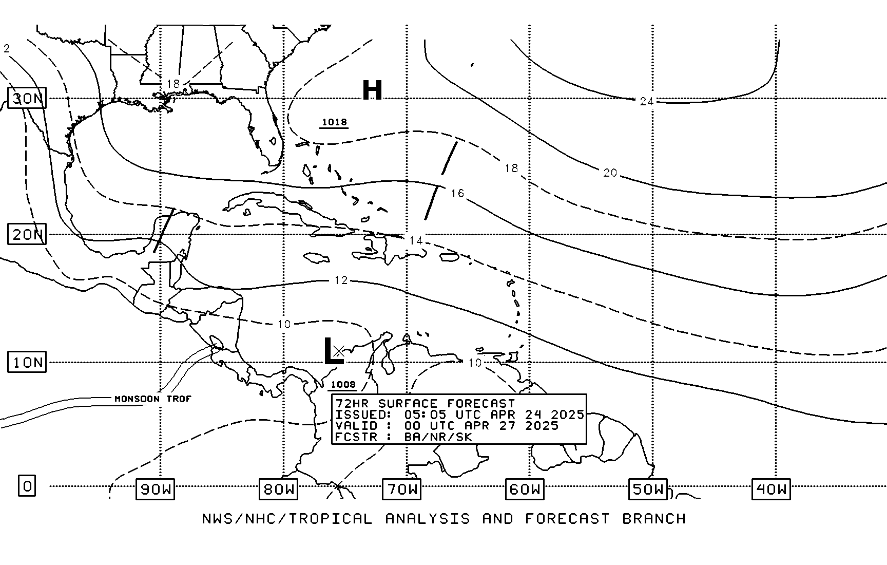
This might be the final call for the 2008 Hurricane Season. The consistency of the GFS runs gives this scenerio credibility. The TAFB has been showing a low meandering near the Panama coast, I wonder if this is the low the GFS is picking up on?
http://www.nhc.noaa.gov/tafb_latest/atl ... BW_sm3.gif
http://www.nhc.noaa.gov/tafb_latest/atl ... BW_sm3.gif
0 likes
- gatorcane
- S2K Supporter

- Posts: 23708
- Age: 48
- Joined: Sun Mar 13, 2005 3:54 pm
- Location: Boca Raton, FL
Re: GFS/Euro/NGPS/UKM: Tropical Low in SW Carib. in 6 Days
Sanibel wrote:Panama disturbance too weak.
It's not the Panama convection you are seeing currently that the GFS develops into a tropical cyclone. Things get going with a low that pushes off South America from a westward moving Tropical Wave in roughly 3 days or so but still takes several days after to organize into a tropical disturbance.
TAFB shows a low in the SW Caribbean at 72 hours:

12Z GFS -- look how it deepens this low at 228 hours as it drifts northward into the NW Caribbean.

0 likes
- Blown Away
- S2K Supporter

- Posts: 10253
- Joined: Wed May 26, 2004 6:17 am
Re: GFS/Euro/NGPS/UKM: Tropical Low in SW Carib. in 6 Days
Gatorcane, do you think the deep convection we are seeing off the Panama coast is the early stages of the low that is predicted to develop in a few days?
0 likes
- gatorcane
- S2K Supporter

- Posts: 23708
- Age: 48
- Joined: Sun Mar 13, 2005 3:54 pm
- Location: Boca Raton, FL
Re: GFS/Euro/NGPS/UKM: Tropical Low in SW Carib. in 6 Days
Blown_away wrote:Gatorcane, do you think the deep convection we are seeing off the Panama coast is the early stages of the low that is predicted to develop in a few days?
Nope GFS develops a tropical wave moving west across the Caribbean....lets see what it looks like in about 3 days (end of this coming weekend) but if it develops its probably not going to be until the end of next week so we have plenty of time to watch it.
0 likes
Re: GFS/Euro/NGPS/UKM: Tropical Low in SW Carib. in 6 Days
Edit:
TAFB must pull a second LOW in behind the one vacating Panama now.
TAFB must pull a second LOW in behind the one vacating Panama now.
0 likes
- Blown Away
- S2K Supporter

- Posts: 10253
- Joined: Wed May 26, 2004 6:17 am
Re: GFS/Euro/NGPS/UKM: Tropical Low in SW Carib. in 6 Days

The GFS track seems to follow climatology.
0 likes
Re: GFS/Euro/NGPS/UKM: Tropical Low in SW Carib. in 6 Days
Excerpt from Dr. Jeff Master's blog today....
The UKMET, NOGAPS, and ECMWF have all been pointing to the possible development of a tropical depression in the south central Caribbean Sea 6-7 days from now, off the coast of Nicaragua. I give a 40% chance that we will see a tropical depression form in the Caribbean 5-10 days from now--the upper level environment looks conducive for tropical cyclone development next week. A tropical wave, currently about 500 miles east of the Lesser Antilles Islands, is under high wind shear and is not a threat to develop.
http://www.wunderground.com/blog/JeffMasters/comment.html?entrynum=1140
0 likes
Who is online
Users browsing this forum: gib and 253 guests


