System off NC coast?
Moderator: S2k Moderators
Forum rules

The posts in this forum are NOT official forecasts and should not be used as such. They are just the opinion of the poster and may or may not be backed by sound meteorological data. They are NOT endorsed by any professional institution or STORM2K. For official information, please refer to products from the National Hurricane Center and National Weather Service.

-
george_r_1961

- S2K Supporter

- Posts: 3171
- Age: 64
- Joined: Sat Oct 12, 2002 9:14 pm
- Location: Carbondale, Pennsylvania
Re: System off NC coast?
CaneMaster wrote:Don't think a Nor'Easter is warm core ... is it??
There is no strict definition of a noreaster but that term is usually applied to cold core system.
We have winds gusting to 40mph here in Hampton. More than we got from Hanna.
0 likes
-
Stephanie

- S2K Supporter
- Posts: 23843
- Age: 63
- Joined: Thu Feb 06, 2003 9:53 am
- Location: Glassboro, NJ
Re: System off NC coast?
Issued by The National Weather Service
Philadelphia, PA
3:01 pm EST, Wed., Nov. 5, 2008
... WIND ADVISORY IN EFFECT UNTIL MIDNIGHT EST TONIGHT...
THE NATIONAL WEATHER SERVICE IN MOUNT HOLLY HAS ISSUED A WIND ADVISORY... WHICH IS IN EFFECT UNTIL MIDNIGHT EST TONIGHT.
A STRONG AREA OF LOW PRESSURE OFF THE NORTH CAROLINA COAST WAS MOVING NORTHEASTWARD. THE PRESSURE GRADIENT BETWEEN THIS LOW PRESSURE SYSTEM AND HIGH PRESSURE TO THE NORTHWEST WILL CREATE STRONG AND GUSTY WINDS FOR THE COASTS OF EXTREME SOUTHERN NEW JERSEY AND DELAWARE. WIND SPEEDS OF 2O TO 3O MPH WITH GUSTS TO AROUND 45 MPH ARE LIKELY UNTIL ABOUT MIDNIGHT.
RESIDENTS IN THE WIND ADVISORY AREA SHOULD TAKE THE NECESSARY PRECAUTIONS TO SECURE ANY OBJECTS THAT COULD BECOME AIRBORNE IN STRONG WINDS. DRIVERS OF LIGHTWEIGHT AND HIGH PROFILE VEHICLES SHOULD EXERCISE CAUTION AND SLOW DOWN WHEN TRAVELING THIS EVENING.
0 likes
-
CaneMaster
Re: System off NC coast?
it's almost like this is the second time they dropped the ball on this one, even jconsor posted it was warm core we got robbed of a name twice??
0 likes
-
CaneMaster


-
Tampa Bay Hurricane

- Category 5

- Posts: 5598
- Age: 38
- Joined: Fri Jul 22, 2005 7:54 pm
- Location: St. Petersburg, FL
-
CaneMaster
Re: System off NC coast?
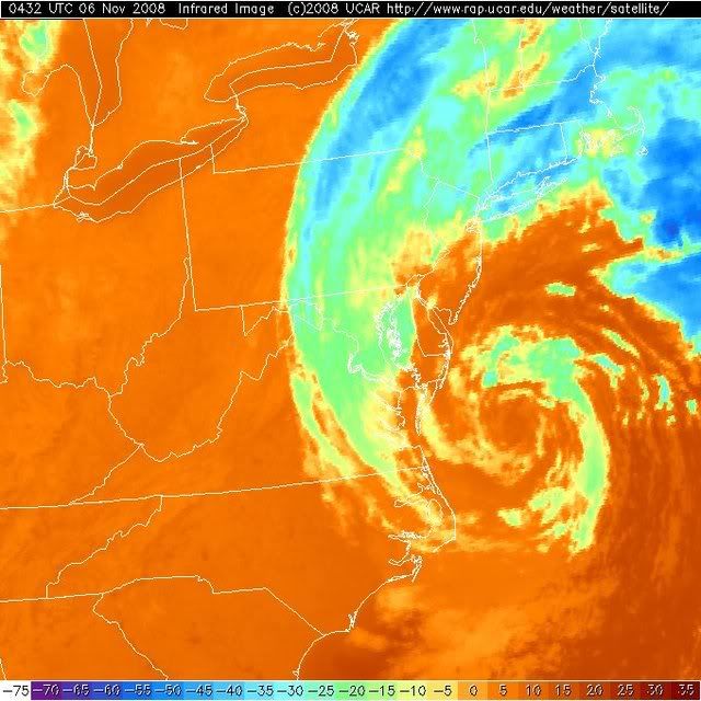
Couldn't help but notice how it was looking this morning check it out....


0 likes
-
CaneMaster
Here's a link to Visible loop at the moment, this looks really really good compared to yesterday, almost like it's organizing more or something, I just don't see much for depth in the clouds but other than that this thing is looking pretty good this morning...
http://www.rap.ucar.edu/weather/satellite/displaySat.php?region=BWI&itype=vis&size=small&endDate=20081106&endTime=-1&duration=12
http://www.rap.ucar.edu/weather/satellite/displaySat.php?region=BWI&itype=vis&size=small&endDate=20081106&endTime=-1&duration=12
0 likes

-
CaneMaster
-
CaneMaster
Re: System off NC coast?
Strange how it look's like this on visible but water vapor and infra-red aren't picking up much on it, is this a low level circulation?


0 likes


-
Derek Ortt
Re:
Tampa Bay Hurricane wrote:With jconsor's input, I think this was subtropical easily- just like the unnamed
subtropical system about a month or so ago...
The mid-atlantic has had many systems this year- 2 unnamed subtropical
systems, TS Hanna, TS Cristobal...4 storms in a year...wow.
the unnamed storm about a month ago was frontal!. Nothing subtropical about a frontal cyclone
0 likes
-
CaneMaster
-
CaneMaster
what is the buz on this derek? you hear much about it, or are they just not giving it any attention or what..? was it a trop storm at one time ? I know since yesterday this thing has gotten a nicer structure even though it's not showing much for vapor and ir, I know we've got some pretty good pooling and flooding from all the rain this thing's given us over the last day or 2.
0 likes
-
CaneMaster
Re: Re:
Derek Ortt wrote:Tampa Bay Hurricane wrote:With jconsor's input, I think this was subtropical easily- just like the unnamed
subtropical system about a month or so ago...
The mid-atlantic has had many systems this year- 2 unnamed subtropical
systems, TS Hanna, TS Cristobal...4 storms in a year...wow.
the unnamed storm about a month ago was frontal!. Nothing subtropical about a frontal cyclone
How come they said it'll probably be named in post-season analysis as it acquired tropical characteristics and split off from the front, it started off frontal but didn't finish that way, the core was way warmer than the rest, and it was a tropical system I experienced it first hand. It brought us more than Hanna did.
0 likes
-
CaneMaster
-
superfly
Who is online
Users browsing this forum: jconsor and 121 guests