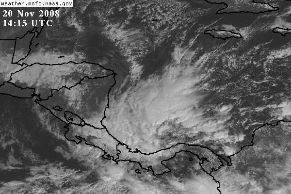
Area of disturbed weather in SW Caribbean (Is invest 96L)
Moderator: S2k Moderators
Forum rules

The posts in this forum are NOT official forecasts and should not be used as such. They are just the opinion of the poster and may or may not be backed by sound meteorological data. They are NOT endorsed by any professional institution or STORM2K. For official information, please refer to products from the National Hurricane Center and National Weather Service.
-
CourierPR

- Category 5

- Posts: 1336
- Age: 71
- Joined: Tue Aug 31, 2004 7:53 pm
- Location: Pompano Beach, Florida
Re: Long-Range Models Hinting at Tropical Low in SW Caribbean
Hurakan, will that wave enhance this system?
0 likes
-
HURAKAN

- Professional-Met

- Posts: 46086
- Age: 38
- Joined: Thu May 20, 2004 4:34 pm
- Location: Key West, FL
- Contact:
Re: Long-Range Models Hinting at Tropical Low in SW Caribbean
CourierPR wrote:Hurakan, will that wave enhance this system?
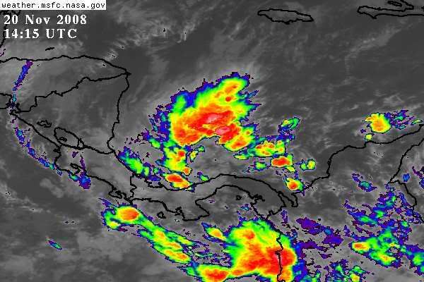
That's very likely but we have to wait. Usually when a frontal boundary interacts with a tropical wave you get an increase in convecton and this system has already been quite persistent.
0 likes
Re: Long-Range Models Hinting at Tropical Low in SW Caribbean
Formational curvature suggests development.
0 likes
-
tolakram
- Admin

- Posts: 20168
- Age: 62
- Joined: Sun Aug 27, 2006 8:23 pm
- Location: Florence, KY (name is Mark)
Re: Long-Range Models Hinting at Tropical Low in SW Caribbean

Looks like shear blowing the tops off to me.
0 likes
Re: Long-Range Models Hinting at Tropical Low in SW Caribbean
A little far south but this is cool because it is late action.
Almost looks like a ULL drilling down. Axis could be over Panama.
Almost looks like a ULL drilling down. Axis could be over Panama.
0 likes
-
gatorcane

- S2K Supporter

- Posts: 23703
- Age: 47
- Joined: Sun Mar 13, 2005 3:54 pm
- Location: Boca Raton, FL
Re: Long-Range Models Hinting at Tropical Low in SW Caribbean
Models are still generally showing lower pressures in the SW Caribbean for the next week or so but none of them are wanting to spin anything up more than a weak surface low. Still for this late in the season, it is something to watch considering the lack of activity across the Atlantic basin (as would be expected for Nov 20th)
0 likes

Re: Long-Range Models Hinting at Tropical Low in SW Caribbean
If it is still there tomorrow morning: Persistence.
0 likes

Re: Long-Range Models Hinting at Tropical Low in SW Caribbean
Weak persistence but conditions aren't supporting it.
It's still cool that we had an inactive Spetember followed by an active Caribbean.
It's still cool that we had an inactive Spetember followed by an active Caribbean.
0 likes

It might actually form into something - we'll see...
Here's the weather ob from my favorite station, MPTO (Panama Canal Zone) - they always have an air temp of 30C, even in the winter (of course they are not too far from the equator):
http://weather.noaa.gov/weather/current/MPTO.html
it is interesting to note that they do have a WNW wind and a lowering pressure in the past hour (too early in the day for diurnal pressure falls, since they are on the same longitude as Miami), so, that might be an indication of something to their north...
I'll guess and say that it'll be mentioned in the next TWO, since it has persisted, as others mentioned here...
Frank
0 likes
-
HURAKAN
- Professional-Met
- Posts: 46086
- Age: 38
- Joined: Thu May 20, 2004 4:34 pm
- Location: Key West, FL
- Contact:
Re: Area of disturbed weather in the SW Caribbean
TROPICAL WEATHER DISCUSSION
NWS TPC/NATIONAL HURRICANE CENTER MIAMI FL
105 PM EST FRI NOV 21 2008
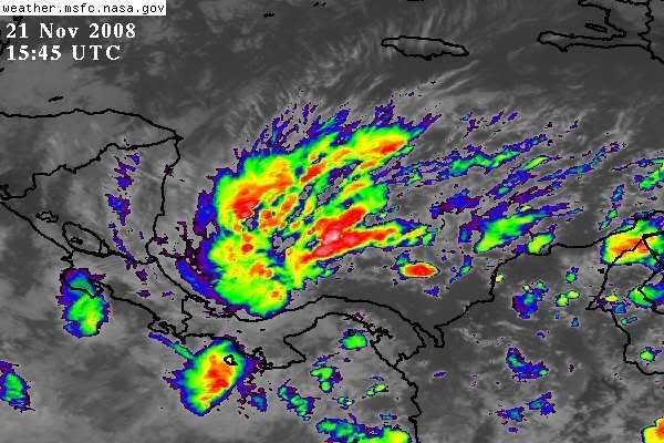
CARIBBEAN SEA...
IN THE SW CARIBBEAN...A 1009 MB SURFACE LOW IS LOCATED N OF
PANAMA NEAR 10N81W. ADDITIONALLY...A SURFACE STATIONARY FRONT
EXTENDS NE FROM THIS SURFACE LOW TO 15N77W TO 20N64W. LOW LEVEL
CONVERGENCE NEAR THE SURFACE LOW AND SURFACE FRONT IS
INTERACTING WITH DEEP LAYER MOISTURE OVER THE S CARIBBEAN TO
GENERATE SCATTERED SHOWERS AND THUNDERSTORMS OVER THE S
CARIBBEAN S OF 15N W OF 77W. SCATTERED SHOWERS ARE ALSO OVER THE
E CARIBBEAN E OF 70W. ISOLATED MODERATE CONVECTION IS OVER THE
SE CARIBBEAN FROM 11N-14N BETWEEN 60W-68W. IN THE UPPER LEVELS
...A RIDGE COVERS THE ENTIRE CARIBBEAN SEA WITH AXIS FROM
TRINIDAD TO THE YUCATAN PENINSULA. SIGNIFICANT UPPER LEVEL
MOISTURE IS S OF 16N. EXPECT... LITTLE CHANGE WITH THE
STATIONARY FRONT FOR THE NEXT 24 HOURS.
NWS TPC/NATIONAL HURRICANE CENTER MIAMI FL
105 PM EST FRI NOV 21 2008
CARIBBEAN SEA...
IN THE SW CARIBBEAN...A 1009 MB SURFACE LOW IS LOCATED N OF
PANAMA NEAR 10N81W. ADDITIONALLY...A SURFACE STATIONARY FRONT
EXTENDS NE FROM THIS SURFACE LOW TO 15N77W TO 20N64W. LOW LEVEL
CONVERGENCE NEAR THE SURFACE LOW AND SURFACE FRONT IS
INTERACTING WITH DEEP LAYER MOISTURE OVER THE S CARIBBEAN TO
GENERATE SCATTERED SHOWERS AND THUNDERSTORMS OVER THE S
CARIBBEAN S OF 15N W OF 77W. SCATTERED SHOWERS ARE ALSO OVER THE
E CARIBBEAN E OF 70W. ISOLATED MODERATE CONVECTION IS OVER THE
SE CARIBBEAN FROM 11N-14N BETWEEN 60W-68W. IN THE UPPER LEVELS
...A RIDGE COVERS THE ENTIRE CARIBBEAN SEA WITH AXIS FROM
TRINIDAD TO THE YUCATAN PENINSULA. SIGNIFICANT UPPER LEVEL
MOISTURE IS S OF 16N. EXPECT... LITTLE CHANGE WITH THE
STATIONARY FRONT FOR THE NEXT 24 HOURS.
0 likes

-
HURAKAN
- Professional-Met
- Posts: 46086
- Age: 38
- Joined: Thu May 20, 2004 4:34 pm
- Location: Key West, FL
- Contact:
Re: Area of disturbed weather in the SW Caribbean
PJRH - MARITIME-ship
Friday Nov. 21 - 18:00 UTCAir Temperature: 78°F
Dewpoint: 77°F
Wind: N at 28 mph
Pressure: 1012.6 mb
Weather: Sleet
Wave Height: 8 ft
Sea Surface Temp: 84.2°F
I don't know what this ship is serving because sleet in the South Caribbean is very difficult to get, even in the last Ice Age.
Friday Nov. 21 - 18:00 UTCAir Temperature: 78°F
Dewpoint: 77°F
Wind: N at 28 mph
Pressure: 1012.6 mb
Weather: Sleet
Wave Height: 8 ft
Sea Surface Temp: 84.2°F
I don't know what this ship is serving because sleet in the South Caribbean is very difficult to get, even in the last Ice Age.
0 likes
Re: Area of disturbed weather in the SW Caribbean
No doubt (?) it's coded wrong, since that's from a 18Z weather observation in WMO format...
Per their call sign, that came from the vessel Cold Stream (Netherlands)...
Here's their observation summary:
http://www.sailwx.info/shiptrack/shippo ... ?call=PJRH
However, even in coded form it'd be ice pellets, not sleet (it was indicated as sleet, prior to 1970, per NOAA)...
It might have been small hail from a TS, but, it should have been indicated as hail, not ice pellets...
Still, it is Friday afternoon...
LOL
0 likes


-
vbhoutex

- Storm2k Executive
- Posts: 29139
- Age: 74
- Joined: Wed Oct 09, 2002 11:31 pm
- Location: Cypress, TX
- Contact:
Re: Area of disturbed weather in the SW Caribbean
I haven't followed this one closely, but it appears to be stationary or wandering around. It is obviously further West than it was earlier in its' existence. Is there a definitive movement or trend of movement in any one direction? They are going to have to add another P to the alphabet if this one ever gets a name. It will be Persistance. Now is that a male or female name? Oh, uh, never mind. I know that answer!!!!! 
0 likes
Who is online
Users browsing this forum: Blown Away, jconsor and 128 guests