Tropical Wave west of Cape Verde
Moderator: S2k Moderators
Forum rules

The posts in this forum are NOT official forecasts and should not be used as such. They are just the opinion of the poster and may or may not be backed by sound meteorological data. They are NOT endorsed by any professional institution or STORM2K. For official information, please refer to products from the National Hurricane Center and National Weather Service.

-
StormTracker

- S2K Supporter

- Posts: 2909
- Age: 59
- Joined: Thu Jun 29, 2006 6:06 am
- Location: Quail Heights(Redlands), FL.
Re: Tropical Wave west of Cape Verde

I wonder if it'll draw in some of that moisture behind that's still over land
0 likes
-
wxman57

- Moderator-Pro Met

- Posts: 23122
- Age: 68
- Joined: Sat Jun 21, 2003 8:06 pm
- Location: Houston, TX (southwest)
Re:
leanne_uk wrote:anyone got the latest sat pictures and wind speeds etc.. for this storm?
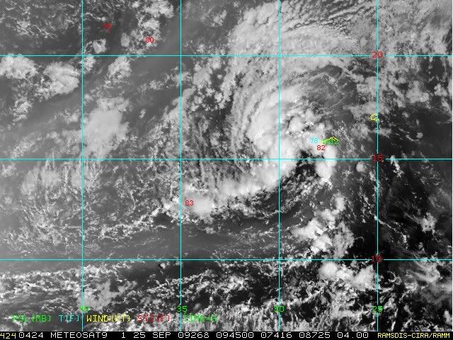
Here's one with a few surface obs. 15kts in the area of convection. Just a weak low moving into a very dry environment for now. Most likely it won't make it.

0 likes
-
wxman57
- Moderator-Pro Met
- Posts: 23122
- Age: 68
- Joined: Sat Jun 21, 2003 8:06 pm
- Location: Houston, TX (southwest)
Re:
leanne_uk wrote:thanks guysi know the environmental conditions are not totall favourable Wx but is there still an outside chance in your opinion of it overcoming the dry air and continue to develop?
I'd agree with the NHC that it has less than 30% chance of developing in the next few days.
0 likes
-
leanne_uk
- Tropical Storm

- Posts: 214
- Age: 42
- Joined: Fri Sep 04, 2009 4:38 pm
- Location: Loughborough countryside, Leicestershire, UK
Re: Re:
wxman57 wrote:leanne_uk wrote:thanks guys
I'd agree with the NHC that it has less than 30% chance of developing in the next few days.
Thanks
0 likes
-
cycloneye

- Admin

- Posts: 148736
- Age: 69
- Joined: Thu Oct 10, 2002 10:54 am
- Location: San Juan, Puerto Rico
Re: Tropical Wave west of Cape Verde
TROPICAL WEATHER OUTLOOK
NWS TPC/NATIONAL HURRICANE CENTER MIAMI FL
800 PM EDT THU SEP 24 2009
FOR THE NORTH ATLANTIC...CARIBBEAN SEA AND THE GULF OF MEXICO...
DISORGANIZED SHOWERS AND THUNDERSTORMS LOCATED A COUPLE HUNDRED
MILES WEST OF THE CAPE VERDE ISLANDS ARE ASSOCIATED WITH A
TROPICAL WAVE. SOME SLOW DEVELOPMENT OF THIS SYSTEM IS POSSIBLE
DURING THE NEXT DAY OR TWO AS IT MOVES WEST-NORTHWESTWARD AT 10 TO
15 MPH. THERE IS A LOW CHANCE...LESS THAN 30 PERCENT...OF THIS
SYSTEM BECOMING A TROPICAL CYCLONE DURING THE NEXT 48 HOURS.
ELSEWHERE...TROPICAL CYCLONE FORMATION IS NOT EXPECTED DURING THE
NEXT 48 HOURS.
$$
FORECASTER BROWN
0 likes


-
HURAKAN

- Professional-Met

- Posts: 46086
- Age: 38
- Joined: Thu May 20, 2004 4:34 pm
- Location: Key West, FL
- Contact:
TROPICAL WEATHER DISCUSSION
NWS TPC/NATIONAL HURRICANE CENTER MIAMI FL
805 AM EDT FRI SEP 25 2009
...TROPICAL WAVES...
TROPICAL WAVE IS FROM 19N29W THROUGH A 1012 MB LOW NEAR 14N30W
TO 10N31W MOVING W NEAR 15 KT. WAVE IS ALONG THE LEADING EDGE OF
A MOISTURE MAXIMUM AS INDICATED BY THE TOTAL PRECIPITABLE WATER
IMAGERY WITH SAHARAN DUST BEING DRAWN INTO THE SURFACE LOW.
CLUSTERS OF SCATTERED MODERATE/ISOLATED STRONG CONVECTION ARE
FROM 13N-19N BETWEEN 27W-32W WITH CLUSTERS OF SCATTERED MODERATE
CONVECTION FROM 9N-14N BETWEEN 26W-35W.
0 likes
-
cycloneye
- Admin
- Posts: 148736
- Age: 69
- Joined: Thu Oct 10, 2002 10:54 am
- Location: San Juan, Puerto Rico
Re: Tropical Wave west of Cape Verde
Is invest 99L so thread is locked.Lets continue the discussions at the 99L thread at Active Storms forum.
Link to 99L thread.
viewtopic.php?f=59&t=106694&p=1927373#p1927373
Link to 99L thread.
viewtopic.php?f=59&t=106694&p=1927373#p1927373
0 likes
Who is online
Users browsing this forum: Hurricanehink and 59 guests