Complex in Northeast GOM
Moderator: S2k Moderators
Forum rules

The posts in this forum are NOT official forecasts and should not be used as such. They are just the opinion of the poster and may or may not be backed by sound meteorological data. They are NOT endorsed by any professional institution or STORM2K. For official information, please refer to products from the National Hurricane Center and National Weather Service.
-
SEASON_CANCELED

- Category 3

- Posts: 887
- Joined: Mon Jul 06, 2009 5:17 am
- Location: 8 Bit Charlie Sheen
Re: Complex near S FL- 0%
poof 
0 likes
i am a big stupid ugly moron with an ugly face and a big butt and my butt stinks and i like to kiss my own butt
-
OuterBanker
- S2K Supporter

- Posts: 1761
- Joined: Wed Feb 26, 2003 10:53 am
- Location: Nags Head, NC
- Contact:
-
tolakram
- Admin

- Posts: 20168
- Age: 62
- Joined: Sun Aug 27, 2006 8:23 pm
- Location: Florence, KY (name is Mark)
Re: Complex near S FL- 0%
ZCZC MIATWOAT ALL
TTAA00 KNHC DDHHMM
TROPICAL WEATHER OUTLOOK
NWS NATIONAL HURRICANE CENTER MIAMI FL
200 AM EDT MON JUL 23 2012
FOR THE NORTH ATLANTIC...CARIBBEAN SEA AND THE GULF OF MEXICO...
1. CLOUDINESS AND SHOWERS ASSOCIATED WITH A WEAK LOW PRESSURE TROUGH
OVER THE FLORIDA PENINSULA HAVE DIMINISHED. CONDITIONS ARE NOT
CONDUCIVE FOR SIGNIFICANT DEVELOPMENT...AND THIS SYSTEM HAS A LOW
CHANCE...NEAR 0 PERCENT...OF BECOMING A TROPICAL CYCLONE DURING THE
NEXT 48 HOURS.
ELSEWHERE...TROPICAL CYCLONE FORMATION IS NOT EXPECTED DURING THE
NEXT 48 HOURS.
$$
FORECASTER PASCH
NNNN
0 likes
M a r k
- - - - -
Join us in chat: Storm2K Chatroom Invite. Android and IOS apps also available.
The posts in this forum are NOT official forecasts and should not be used as such. Posts are NOT endorsed by any professional institution or STORM2K.org. For official information and forecasts, please refer to NHC and NWS products.

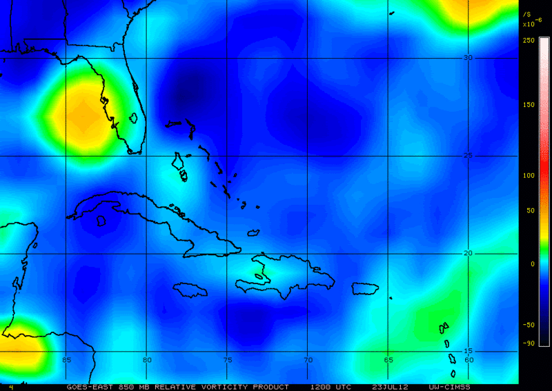
Unlike yesterday, the tropical wave now has a nice H85 vorticity west of Tampa this morning, with a little bit of convection increasing near it this morning.
The NHC has it right with near 0% of development, the vorticity only has 12-24 hrs over water left. With surface pressures if anything higher than yesterday in the NE GOM.
The NHC has it right with near 0% of development, the vorticity only has 12-24 hrs over water left. With surface pressures if anything higher than yesterday in the NE GOM.
0 likes
-
Stormcenter
- S2K Supporter
- Posts: 6685
- Joined: Wed Sep 03, 2003 11:27 am
- Location: Houston, TX
-
MGC

- S2K Supporter
- Posts: 5938
- Joined: Sun Mar 23, 2003 9:05 pm
- Location: Pass Christian MS, or what is left.
Re: Complex near S FL- 0%
It does have a nice spin to it this morning....with a little convection....should run out of water before it has a chance to really spin up....might increase my rain chances the next couple of days.......MGC
0 likes
-
Stormcenter
- S2K Supporter
- Posts: 6685
- Joined: Wed Sep 03, 2003 11:27 am
- Location: Houston, TX
Re: Complex near S FL- 0%
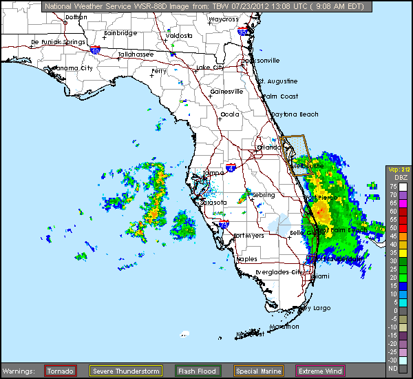
On radar it "looks" like the spin is moving westward.
http://radar.weather.gov/radar.php?prod ... H&loop=yes
http://radar.weather.gov/radar.php?prod ... H&loop=yes
MGC wrote:It does have a nice spin to it this morning....with a little convection....should run out of water before it has a chance to really spin up....might increase my rain chances the next couple of days.......MGC
0 likes
-
cycloneye

- Admin
- Posts: 148730
- Age: 69
- Joined: Thu Oct 10, 2002 10:54 am
- Location: San Juan, Puerto Rico
Re: Complex near S FL- 0%
TROPICAL WEATHER OUTLOOK
NWS NATIONAL HURRICANE CENTER MIAMI FL
200 PM EDT MON JUL 23 2012
FOR THE NORTH ATLANTIC...CARIBBEAN SEA AND THE GULF OF MEXICO...
A WEAK SURFACE LOW PRESSURE SYSTEM LOCATED OVER THE NORTHEASTERN
GULF OF MEXICO ABOUT 90 MILES SOUTH-SOUTHEAST OF APALACHICOLA
FLORIDA IS PRODUCING SCATTERED THUNDERSTORMS ACROSS CENTRAL AND
NORTH FLORIDA...AND ADJACENT GULF OF MEXICO AND ATLANTIC WATERS.
THIS BROAD DISTURBANCE WILL BE MOVING INLAND OVER THE FLORIDA
PANHANDLE BY TUESDAY MORNING...AND CONDITIONS ARE NOT CONDUCIVE
FOR SIGNIFICANT DEVELOPMENT TO OCCUR WHILE IT REMAINS OVER WATER.
THIS SYSTEM HAS A LOW CHANCE...NEAR 0 PERCENT...OF BECOMING A
TROPICAL CYCLONE DURING THE NEXT 48 HOURS AS IT MOVES NORTHWARD AT
10 TO 15 MPH.
ELSEWHERE...TROPICAL CYCLONE FORMATION IS NOT EXPECTED DURING THE
NEXT 48 HOURS.
$$
FORECASTER STEWART
0 likes
Visit the Caribbean-Central America Weather Thread where you can find at first post web cams,radars
and observations from Caribbean basin members Click Here
and observations from Caribbean basin members Click Here
-
TropicalAnalystwx13

- Category 5

- Posts: 2109
- Age: 28
- Joined: Tue Jul 19, 2011 8:20 pm
- Location: Wilmington, NC
- Contact:
Tropical Cyclone formation is not expected during the next 48 hours.
TROPICAL WEATHER OUTLOOK
NWS NATIONAL HURRICANE CENTER MIAMI FL
800 PM EDT MON JUL 23 2012
FOR THE NORTH ATLANTIC...CARIBBEAN SEA AND THE GULF OF MEXICO...
TROPICAL CYCLONE FORMATION IS NOT EXPECTED DURING THE NEXT 48 HOURS.
$$
FORECASTER BLAKE
TROPICAL WEATHER OUTLOOK
NWS NATIONAL HURRICANE CENTER MIAMI FL
800 PM EDT MON JUL 23 2012
FOR THE NORTH ATLANTIC...CARIBBEAN SEA AND THE GULF OF MEXICO...
TROPICAL CYCLONE FORMATION IS NOT EXPECTED DURING THE NEXT 48 HOURS.
$$
FORECASTER BLAKE
0 likes


-
Stormcenter
- S2K Supporter
- Posts: 6685
- Joined: Wed Sep 03, 2003 11:27 am
- Location: Houston, TX
-
northjaxpro

- S2K Supporter
- Posts: 8900
- Joined: Mon Sep 27, 2010 11:21 am
- Location: Jacksonville, FL
Indeed, it is still hanging around in the NE GOM. Dry air is the biggest hindrance with this disturbance, but if this is still hanging around in the next day or two, we may need to start paying more attention to this.
0 likes
NEVER, EVER SAY NEVER in the tropics and weather in general, and most importantly, with life itself!!
________________________________________________________________________________________
Fay 2008 Beryl 2012 Debby 2012 Colin 2016 Hermine 2016 Julia 2016 Matthew 2016 Irma 2017 Dorian 2019
________________________________________________________________________________________
Fay 2008 Beryl 2012 Debby 2012 Colin 2016 Hermine 2016 Julia 2016 Matthew 2016 Irma 2017 Dorian 2019
-
Dean4Storms
- S2K Supporter
- Posts: 6358
- Age: 62
- Joined: Sun Aug 31, 2003 1:01 pm
- Location: Miramar Bch. FL
This weak low has raised my attention this afternoon. Deeper convection is firing out there and it is now influencing our storm motion. NWS Mobile in its morning discussion expected the motion to be north spreading inland as the afternoon wore on. We have just the opposite, convection firing now along the coast and moving south bound. This still has a circulation and with convection now deepening this afternoon it needs monitoring for sure.
Eglin radar.......
http://radar.weather.gov/radar.php?prod ... X&loop=yes
Eglin radar.......
http://radar.weather.gov/radar.php?prod ... X&loop=yes
0 likes
-
northjaxpro
- S2K Supporter
- Posts: 8900
- Joined: Mon Sep 27, 2010 11:21 am
- Location: Jacksonville, FL
Re: Complex near S F
Yeah Dean I also noticed the southward motion to the convection as well. If you look at visible and WV imagery, there is definitely a rotation, maybe a very weak surface reflection, but more likely in the mid levels currently. I think if the trend continues with convection re-firing and this is still around the next 24 hours, as we both have previously stated, this will need to be watched more closely. Dry air has been the main problem with this system, but shear appears to be at marginally conducive levels currently in the Eastern GOM.
0 likes
NEVER, EVER SAY NEVER in the tropics and weather in general, and most importantly, with life itself!!
________________________________________________________________________________________
Fay 2008 Beryl 2012 Debby 2012 Colin 2016 Hermine 2016 Julia 2016 Matthew 2016 Irma 2017 Dorian 2019
________________________________________________________________________________________
Fay 2008 Beryl 2012 Debby 2012 Colin 2016 Hermine 2016 Julia 2016 Matthew 2016 Irma 2017 Dorian 2019
-
northjaxpro
- S2K Supporter
- Posts: 8900
- Joined: Mon Sep 27, 2010 11:21 am
- Location: Jacksonville, FL
Also, mods it is time edit the title of this thread again. This time to reflect the current location of the disturbance in the Northeast GOM.
0 likes
NEVER, EVER SAY NEVER in the tropics and weather in general, and most importantly, with life itself!!
________________________________________________________________________________________
Fay 2008 Beryl 2012 Debby 2012 Colin 2016 Hermine 2016 Julia 2016 Matthew 2016 Irma 2017 Dorian 2019
________________________________________________________________________________________
Fay 2008 Beryl 2012 Debby 2012 Colin 2016 Hermine 2016 Julia 2016 Matthew 2016 Irma 2017 Dorian 2019
-
Dean4Storms
- S2K Supporter
- Posts: 6358
- Age: 62
- Joined: Sun Aug 31, 2003 1:01 pm
- Location: Miramar Bch. FL
-
northjaxpro
- S2K Supporter
- Posts: 8900
- Joined: Mon Sep 27, 2010 11:21 am
- Location: Jacksonville, FL
Yeah, the dry air continues to be the constant hindrance for this system. Convection can't sustain itself with this feature.
0 likes
NEVER, EVER SAY NEVER in the tropics and weather in general, and most importantly, with life itself!!
________________________________________________________________________________________
Fay 2008 Beryl 2012 Debby 2012 Colin 2016 Hermine 2016 Julia 2016 Matthew 2016 Irma 2017 Dorian 2019
________________________________________________________________________________________
Fay 2008 Beryl 2012 Debby 2012 Colin 2016 Hermine 2016 Julia 2016 Matthew 2016 Irma 2017 Dorian 2019

Re: Complex in Northeast GOM
Another puff of convection this morning over the center. Probably get sheared off though. Its so dry out there that I would only give this about a 1% chance. It would have to pump enough moisture up over the NE gulf to survive and that isn't likely unless the shear drops to almost 0.
0 likes
-
Stormcenter
- S2K Supporter
- Posts: 6685
- Joined: Wed Sep 03, 2003 11:27 am
- Location: Houston, TX
Ok maybe it's time to take a closer look at this area again.
http://www.ssd.noaa.gov/goes/east/gmex/flash-avn.html
http://www.ssd.noaa.gov/goes/east/gmex/flash-avn.html
0 likes
Who is online
Users browsing this forum: No registered users and 62 guests