West PAC - disturbance near 140E (Is Invest 96W)
Moderator: S2k Moderators
Forum rules

The posts in this forum are NOT official forecasts and should not be used as such. They are just the opinion of the poster and may or may not be backed by sound meteorological data. They are NOT endorsed by any professional institution or STORM2K. For official information, please refer to products from the National Hurricane Center and National Weather Service.

Re: West Pacific - Models show strong typhoon next week
Latest 12Z run, EC/GFS/JMA, has this system heading straight for Hainan Island, but CMC has the system heading northwards into Taiwan.
0 likes
-
dexterlabio
- Category 5

- Posts: 3517
- Joined: Sat Oct 24, 2009 11:50 pm
Re: West Pacific - Models show strong typhoon next week
GFS 18Z has it going towards Southern China...and this time not a weak low..
0 likes
Personal Forecast Disclaimer:
The posts in this forum are NOT official forecast and should not be used as such. They are just the opinion of the poster and may or may not be backed by sound meteorological data. They are NOT endorsed by any professional institution or storm2k.org. For official information, please refer to the NHC and NWS products.
The posts in this forum are NOT official forecast and should not be used as such. They are just the opinion of the poster and may or may not be backed by sound meteorological data. They are NOT endorsed by any professional institution or storm2k.org. For official information, please refer to the NHC and NWS products.
-
dexterlabio
- Category 5
- Posts: 3517
- Joined: Sat Oct 24, 2009 11:50 pm
GFS 00z has a strong typhoon tracking towards Batanes-Taiwan area...and that's not in the long range anymore.  the next model runs will be interesting to see if this trend keeps up..
0 likes
Personal Forecast Disclaimer:
The posts in this forum are NOT official forecast and should not be used as such. They are just the opinion of the poster and may or may not be backed by sound meteorological data. They are NOT endorsed by any professional institution or storm2k.org. For official information, please refer to the NHC and NWS products.
The posts in this forum are NOT official forecast and should not be used as such. They are just the opinion of the poster and may or may not be backed by sound meteorological data. They are NOT endorsed by any professional institution or storm2k.org. For official information, please refer to the NHC and NWS products.
Looking at the 0Z run. EC still predicts this TC to move towards Hainan Island. GFS has it veering towards Taiwan instead. Whether the storm will be weak or strong, when it is rounding the subtropical high, may determine its future course. The models forecast the subtropical high to shift eastwards towards Japan.
Time to wait and see.
Time to wait and see.
0 likes
-
xtyphooncyclonex

- Category 5
- Posts: 3898
- Age: 24
- Joined: Sat Dec 08, 2012 9:07 am
- Location: Cebu City
- Contact:
Re: West Pacific - Models show strong typhoon next week
GFS at 177 hr

The posts in this forum are NOT official forecast and should not be used as such. They are just the opinion of the poster and may or may not be backed by sound meteorological data. They are NOT endorsed by any professional institution or storm2k.org.
The posts in this forum are NOT official forecast and should not be used as such. They are just the opinion of the poster and may or may not be backed by sound meteorological data. They are NOT endorsed by any professional institution or storm2k.org.
Last edited by RL3AO on Tue Aug 06, 2013 6:03 am, edited 1 time in total.
Reason: Add disclaimer
Reason: Add disclaimer
0 likes
REMINDER: My opinions that I, or any other NON Pro-Met in this forum, are unofficial. Please do not take my opinions as an official forecast and warning. I am NOT a meteorologist. Following my forecasts blindly may lead to false alarm, danger and risk if official forecasts from agencies are ignored.
-
xtyphooncyclonex
- Category 5
- Posts: 3898
- Age: 24
- Joined: Sat Dec 08, 2012 9:07 am
- Location: Cebu City
- Contact:
Re: West Pacific - Models show strong typhoon next week
I hope this won't hit any landmass so that it won't cause that much damage. It can also be more fun to track if this stays at the sea! If it stays at the sea, this is the track (I predicted this a long time ago):

Utor last 2006 before made landfall in the Visayas. It caused the postponement of the ASEAN Summit in Cebu, which was supposed to be at Dec. 9, 2006 (moved to Jan 2007).
Utor last 2006 before made landfall in the Visayas. It caused the postponement of the ASEAN Summit in Cebu, which was supposed to be at Dec. 9, 2006 (moved to Jan 2007).
0 likes
REMINDER: My opinions that I, or any other NON Pro-Met in this forum, are unofficial. Please do not take my opinions as an official forecast and warning. I am NOT a meteorologist. Following my forecasts blindly may lead to false alarm, danger and risk if official forecasts from agencies are ignored.
-
Typhoon Hunter
- WesternPacificWeather.com

- Posts: 1222
- Joined: Wed Oct 11, 2006 11:37 am
- Location: Tokyo
- Contact:
Re: West Pacific - Models show strong typhoon next week
Yep we're certainly in the near time frame in model terms and that GFS 00z really is a concern. 06z trickling out now.
If this storm does indeed form it will be another epic fail for ECMWF, I think someone should just unplug that model when it comes to spotting tropical cyclone formations...
If this storm does indeed form it will be another epic fail for ECMWF, I think someone should just unplug that model when it comes to spotting tropical cyclone formations...
0 likes

-
RobWESTPACWX
- WestPACMet

- Posts: 1616
- Joined: Fri Sep 17, 2010 2:26 am
- Location: Tokyo, Japan
- Contact:
Re: West Pacific - Models show strong typhoon next week

06Z GFS output for Tuesday morning.. still going strong this run.
0 likes
Satellites, Charts and Forecasting tools for East Asia at WESTERNPACIFICWEATHER.COM
-
RobWESTPACWX
- WestPACMet
- Posts: 1616
- Joined: Fri Sep 17, 2010 2:26 am
- Location: Tokyo, Japan
- Contact:
-
Typhoon Hunter
- WesternPacificWeather.com
- Posts: 1222
- Joined: Wed Oct 11, 2006 11:37 am
- Location: Tokyo
- Contact:
Re: West Pacific - Models show strong typhoon next week
RL3AO wrote:Normally we would just lock this thread and start one in Active Storms, as we would with an Atlantic system.
Although, I wouldn't have a problem just renaming this thread and moving it to active storms.
I like that idea too, if it forms that is!
It's been quite a roller coaster tracking this in the models!
0 likes
-
Blown Away

- S2K Supporter

- Posts: 10253
- Joined: Wed May 26, 2004 6:17 am
Re: West Pacific - Models show strong typhoon next week
xtyphooncyclonex wrote:GFS at 177 hr
WOW, that would be incredible...I hope it doesn't pan out for Taiwan's sake...I do love that graphic, is there a link to get that view?
Last edited by Blown Away on Tue Aug 06, 2013 6:13 am, edited 1 time in total.
0 likes
Hurricane Eye Experience: David 79, Irene 99, Frances 04, Jeanne 04, Wilma 05… Hurricane Brush Experience: Andrew 92, Erin 95, Floyd 99, Matthew 16, Irma 17, Ian 22, Nicole 22…
-
RobWESTPACWX
- WestPACMet
- Posts: 1616
- Joined: Fri Sep 17, 2010 2:26 am
- Location: Tokyo, Japan
- Contact:
-
RobWESTPACWX
- WestPACMet
- Posts: 1616
- Joined: Fri Sep 17, 2010 2:26 am
- Location: Tokyo, Japan
- Contact:
Re: West Pacific - Models show strong typhoon next week
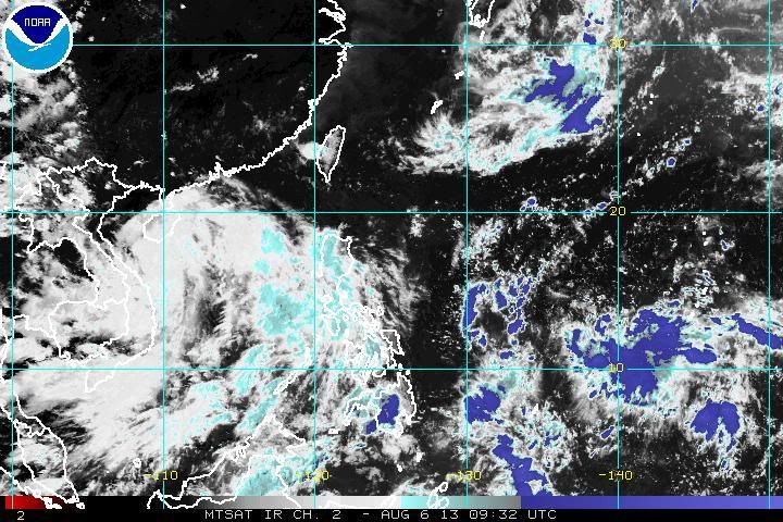
Latest pass on ASCAT, winds picking up. A little disturbed but nothing to get all to nuts over yet.

0 likes
Satellites, Charts and Forecasting tools for East Asia at WESTERNPACIFICWEATHER.COM
-
xtyphooncyclonex
- Category 5
- Posts: 3898
- Age: 24
- Joined: Sat Dec 08, 2012 9:07 am
- Location: Cebu City
- Contact:
Re: West Pacific - Models show strong typhoon next week
Blown Away wrote:xtyphooncyclonex wrote:GFS at 177 hr
WOW, that would be incredible...I hope it doesn't pan out for Taiwan's sake...I do love that graphic, is there a link to get that view?
For the map?
0 likes
REMINDER: My opinions that I, or any other NON Pro-Met in this forum, are unofficial. Please do not take my opinions as an official forecast and warning. I am NOT a meteorologist. Following my forecasts blindly may lead to false alarm, danger and risk if official forecasts from agencies are ignored.
-
RobWESTPACWX
- WestPACMet
- Posts: 1616
- Joined: Fri Sep 17, 2010 2:26 am
- Location: Tokyo, Japan
- Contact:
Re: West Pacific - Models show strong typhoon next week
xtyphooncyclonex wrote:Blown Away wrote:xtyphooncyclonex wrote:GFS at 177 hr
WOW, that would be incredible...I hope it doesn't pan out for Taiwan's sake...I do love that graphic, is there a link to get that view?
For the map?
Thats a Wundermap output, cool tool, you can over lay model, sats a ton of information if your in the states too...
I think he overlayed the track forecast on top of that though.
http://www.wunderground.com/wundermap/
0 likes
Satellites, Charts and Forecasting tools for East Asia at WESTERNPACIFICWEATHER.COM
-
xtyphooncyclonex
- Category 5
- Posts: 3898
- Age: 24
- Joined: Sat Dec 08, 2012 9:07 am
- Location: Cebu City
- Contact:
For the forecast, additional stuff, etc., I used Paint.NET.
I'm so excited to track an Invest!!!
I'm so excited to track an Invest!!!
0 likes
REMINDER: My opinions that I, or any other NON Pro-Met in this forum, are unofficial. Please do not take my opinions as an official forecast and warning. I am NOT a meteorologist. Following my forecasts blindly may lead to false alarm, danger and risk if official forecasts from agencies are ignored.
-
RobWESTPACWX
- WestPACMet
- Posts: 1616
- Joined: Fri Sep 17, 2010 2:26 am
- Location: Tokyo, Japan
- Contact:
Re: West Pacific - Models show strong typhoon next week
At the very least JMA has stamped a LPA in the PH Sea on the 48hr fcst.

0 likes
Satellites, Charts and Forecasting tools for East Asia at WESTERNPACIFICWEATHER.COM
Who is online
Users browsing this forum: No registered users and 180 guests