2015 Global model runs discussion
Moderator: S2k Moderators
Forum rules
The posts in this forum are NOT official forecasts and should not be used as such. They are just the opinion of the poster and may or may not be backed by sound meteorological data. They are NOT endorsed by any professional institution or STORM2K. For official information, please refer to products from the National Hurricane Center and National Weather Service.
- cycloneye
- Admin

- Posts: 149504
- Age: 69
- Joined: Thu Oct 10, 2002 10:54 am
- Location: San Juan, Puerto Rico
Re: Global Model Runs Discussion=GFS has been upgraded
GFS at 240 hours has some bad weather for Louisiana but not a storm like ECMWF. 
0 likes
Visit the Caribbean-Central America Weather Thread where you can find at first post web cams,radars
and observations from Caribbean basin members Click Here
and observations from Caribbean basin members Click Here
- Ivanhater
- Storm2k Moderator

- Posts: 11221
- Age: 39
- Joined: Fri Jul 01, 2005 8:25 am
- Location: Pensacola
Re: Global Model Runs Discussion=GFS has been upgraded
Canadian has the storm at 240 hours as well


0 likes
Michael
-
Stormcenter
- S2K Supporter

- Posts: 6689
- Joined: Wed Sep 03, 2003 11:27 am
- Location: Houston, TX
Re: Global Model Runs Discussion=GFS has been upgraded
Some pre-season model humor while we wait for this darn Winter to end 
0 likes
The following post is NOT an official forecast and should not be used as such. It is just the opinion of the poster and may or may not be backed by sound meteorological data. It is NOT endorsed by any professional institution including storm2k.org For Official Information please refer to the NHC and NWS products.
- gatorcane
- S2K Supporter

- Posts: 23708
- Age: 48
- Joined: Sun Mar 13, 2005 3:54 pm
- Location: Boca Raton, FL
Global model runs discussion
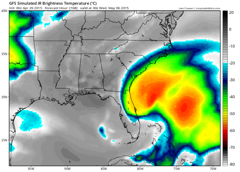
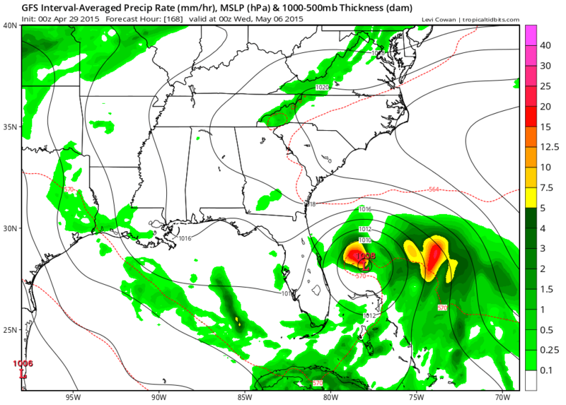
12Z ECMWF shifts west and has this low recurving near the Florida east coast at 216 hours. GFS shifts to the right with a quick recurve on it's latest run. Needless to say very different solutions here:


0 likes
- crownweather
- S2K Supporter

- Posts: 602
- Age: 51
- Joined: Sat Aug 12, 2006 9:21 am
- Location: Sturbridge, Massachusetts
- Contact:
Re:
it's going to be really interesting to see if this even comes close to fruition or if this is model early season antics. Part of me thinks that this is a possibility given the setup of a forecast high pressure setting up to the NE, old front lingering for a few days and the very warm waters there. Yet, another part of me is skeptical since we've been led down this road MANY times before.
gatorcane wrote:12Z ECMWF shifts west and has this low recurving near the Florida east coast at 216 hours. GFS shifts to the right with a quick recurve on it's latest run:
0 likes
Rob Lightbown
Crown Weather Services
https://crownweather.com
Crown Weather Services
https://crownweather.com
-
HURRICANELONNY
- Category 5

- Posts: 1392
- Joined: Wed May 07, 2003 6:48 am
- Location: HOLLYWOOD.FL
Re: Global model runs discussion
Seems alot of El Nino years there is a early sub-trop or tropical system then the dead season. 
0 likes
hurricanelonny
- northjaxpro
- S2K Supporter

- Posts: 8900
- Joined: Mon Sep 27, 2010 11:21 am
- Location: Jacksonville, FL
Well, given the upcoming pattern, and the ssts being a bit warmer than usual for this time of year in the SW Atlantic, I would not be shocked to see if this feature tries to spin up. Could be another early season (May) entity. The interesting thing is that the models have hinted at this possible system for the past few runs going back to Saturday. I will really be interested to see tonight's model runs. But yeah, an interesting situation. I particularly will not take this lightly. Remember, T.S. Beryl in May 2012, ironically currently featured in my avatar, which made history in my neck of the woods at that time.
0 likes
NEVER, EVER SAY NEVER in the tropics and weather in general, and most importantly, with life itself!!
________________________________________________________________________________________
Fay 2008 Beryl 2012 Debby 2012 Colin 2016 Hermine 2016 Julia 2016 Matthew 2016 Irma 2017 Dorian 2019
________________________________________________________________________________________
Fay 2008 Beryl 2012 Debby 2012 Colin 2016 Hermine 2016 Julia 2016 Matthew 2016 Irma 2017 Dorian 2019
- gatorcane
- S2K Supporter

- Posts: 23708
- Age: 48
- Joined: Sun Mar 13, 2005 3:54 pm
- Location: Boca Raton, FL
Global model guidance looks in reasonably good agreement that a trough of low pressure will form in the Bahamas next week, left behind by the strong frontal system to push off the Eastern seaboard of the United States and this trough looks to spawn some kind of low that may spin up into a subtropical or tropical cyclone. I checked the GFS and ECMWF ensembles to see what they show and the MSLP pressure anomalies show lowering pressures over the Bahamas as well, though they don't spin up a consolidated low.
The situation bears watching as we actually have a chance of an pre-season, named system out of this, which if happens, would be 3-4 weeks before the climatological start of the Atlantic hurricane season.
The situation bears watching as we actually have a chance of an pre-season, named system out of this, which if happens, would be 3-4 weeks before the climatological start of the Atlantic hurricane season.
0 likes
Re: Global model runs discussion
HURRICANELONNY wrote:Seems alot of El Nino years there is a early sub-trop or tropical system then the dead season.
"Bingo" Correct on both point. Not to say that its a given that this will be an entirely dead season but true enough, El Nino seasons are often earmarked by early season subtropical (or tropical) systems. Its not uncommon for things to then shut down for 1, 2, or 3 months before producing activity in the heart of the season. That's one of the reasons why I didn't consider it going out on a limb when I mentioned in my season estimate that I thought there would be one or two early season storms. 'Course, that has yet to happen, and may very well not...though the models are starting to tease that it may.
0 likes
Andy D
(For official information, please refer to the NHC and NWS products.)
(For official information, please refer to the NHC and NWS products.)
-
TheStormExpert
Talked about my opinions on this in the Florida Thread since the 12z Euro run showed it coming real close to the East Coast of Florida before recurving. But I'm only interested because the Euro shows it and we saw how badly the GFS did last May/June with the early season "Phantom Storms"(and according to Levi Cowan @ Tropical Tidbits it's kind of starting to do it again!). With the SE U.S. Coast/West Atlantic possibly being the most favorable region IMO all season once again, along with yet again warmer than average SST's it Bears Watching IMO. Shear is one of the biggest possible inhibitors.
0 likes
Re: Global model runs discussion
For the moment, the 18Z GFS run eventually winds this low down to about 987mb in roughly 120 hours, as its approaching Nova Scotia. The depiction thus far however would appear entirely non tropical. Looks like the GFS might have backed off the following weeks' low; a feature forming out of the decaying front lying to the south and east of Florida. Lets see if the 0Z carries it with a bit more gusto or not.
0 likes
Andy D
(For official information, please refer to the NHC and NWS products.)
(For official information, please refer to the NHC and NWS products.)
-
tolakram
- Admin

- Posts: 20186
- Age: 62
- Joined: Sun Aug 27, 2006 8:23 pm
- Location: Florence, KY (name is Mark)
Re: Global model runs discussion
Right now only the upgraded Euro spins this up while the current Euro shows what might be a weak or small area of low pressure, both at about 204 hours. At the end of the run the new Euro has a 1004MB low east of SC, south of the outer banks. GFS is remarkably similar to the new Euro ... let's hope they didn't break the Euro. 
0 likes
M a r k
- - - - -
Join us in chat: Storm2K Chatroom Invite. Android and IOS apps also available.
The posts in this forum are NOT official forecasts and should not be used as such. Posts are NOT endorsed by any professional institution or STORM2K.org. For official information and forecasts, please refer to NHC and NWS products.
- crownweather
- S2K Supporter

- Posts: 602
- Age: 51
- Joined: Sat Aug 12, 2006 9:21 am
- Location: Sturbridge, Massachusetts
- Contact:
Well, the 18Z GFS model certainly is tropical cyclone happy. Forms our low pressure system near Florida's east coast on Tuesday of next week. Initially pulls it out but then is blocked to the north and sent westward. Also noticed that the GFS model may be "handing off" some of the moisture to quickly to the east-northeast from hours 216 to 240.
18Z GFS model also forms a TC in the western Caribbean in the 300 plus hour range. Definitely highly suspect of this and don't believe it at this point.
18Z GFS model also forms a TC in the western Caribbean in the 300 plus hour range. Definitely highly suspect of this and don't believe it at this point.
0 likes
Rob Lightbown
Crown Weather Services
https://crownweather.com
Crown Weather Services
https://crownweather.com
-
tolakram
- Admin

- Posts: 20186
- Age: 62
- Joined: Sun Aug 27, 2006 8:23 pm
- Location: Florence, KY (name is Mark)
Re:
crownweather wrote:18Z GFS model also forms a TC in the western Caribbean in the 300 plus hour range. Definitely highly suspect of this and don't believe it at this point.
Heads up to the EPAC watchers since the GFS usually sniffs out the first EPAC storm but initially puts it in the wrong basin.
0 likes
M a r k
- - - - -
Join us in chat: Storm2K Chatroom Invite. Android and IOS apps also available.
The posts in this forum are NOT official forecasts and should not be used as such. Posts are NOT endorsed by any professional institution or STORM2K.org. For official information and forecasts, please refer to NHC and NWS products.
- - - - -
Join us in chat: Storm2K Chatroom Invite. Android and IOS apps also available.
The posts in this forum are NOT official forecasts and should not be used as such. Posts are NOT endorsed by any professional institution or STORM2K.org. For official information and forecasts, please refer to NHC and NWS products.
Who is online
Users browsing this forum: No registered users and 184 guests


