Tropical Wave in the East-Central Caribbean (Is Invest 92L)
Moderator: S2k Moderators
Forum rules

The posts in this forum are NOT official forecasts and should not be used as such. They are just the opinion of the poster and may or may not be backed by sound meteorological data. They are NOT endorsed by any professional institution or STORM2K. For official information, please refer to products from the National Hurricane Center and National Weather Service.
Re: Tropical Wave East of the Lesser Antilles
12Z UKMET: once again no Caribbean TC genesis through 144 hours
1 likes
Personal Forecast Disclaimer:
The posts in this forum are NOT official forecasts and should not be used as such. They are just the opinion of the poster and may or may not be backed by sound meteorological data. They are NOT endorsed by any professional institution or storm2k.org. For official information, please refer to the NHC and NWS products.
The posts in this forum are NOT official forecasts and should not be used as such. They are just the opinion of the poster and may or may not be backed by sound meteorological data. They are NOT endorsed by any professional institution or storm2k.org. For official information, please refer to the NHC and NWS products.
-
SouthFLTropics

- Category 5

- Posts: 4258
- Age: 50
- Joined: Thu Aug 14, 2003 8:04 am
- Location: Port St. Lucie, Florida
Re: Tropical Wave East of the Lesser Antilles
caneseddy wrote:12z GFS doesn’t do much with it until it gets into the Gulf where after getting close to Louisiana decides to make a hard right and seems to follow the coastline as an intensifying hurricane
Landfall as Cat1/2 in Panama City
The ironic thing here is that the 288 hour position between the 06z and the 12z are almost identical, but they took two totally different routes to get there.

5 likes
Fourth Generation Florida Native
Personal Storm History: David 79, Andrew 92, Erin 95, Floyd 99, Irene 99, Frances 04, Jeanne 04, Wilma 05, Matthew 16, Irma 17, Ian 22, Nicole 22, Milton 24
Personal Storm History: David 79, Andrew 92, Erin 95, Floyd 99, Irene 99, Frances 04, Jeanne 04, Wilma 05, Matthew 16, Irma 17, Ian 22, Nicole 22, Milton 24
-
toad strangler

- S2K Supporter

- Posts: 4546
- Joined: Sun Jul 28, 2013 3:09 pm
- Location: Earth
- Contact:
Re: Tropical Wave East of the Lesser Antilles
12z CMC looks much more climatologically correct than the 12z GFS 
Pretty much same end result
Pretty much same end result
0 likes
My Weather Station
https://www.wunderground.com/dashboard/pws/KFLPORTS603
https://www.wunderground.com/dashboard/pws/KFLPORTS603
-
SouthFLTropics
- Category 5
- Posts: 4258
- Age: 50
- Joined: Thu Aug 14, 2003 8:04 am
- Location: Port St. Lucie, Florida
Re: Tropical Wave East of the Lesser Antilles
12z CMC

1 likes
Fourth Generation Florida Native
Personal Storm History: David 79, Andrew 92, Erin 95, Floyd 99, Irene 99, Frances 04, Jeanne 04, Wilma 05, Matthew 16, Irma 17, Ian 22, Nicole 22, Milton 24
Personal Storm History: David 79, Andrew 92, Erin 95, Floyd 99, Irene 99, Frances 04, Jeanne 04, Wilma 05, Matthew 16, Irma 17, Ian 22, Nicole 22, Milton 24
-
Spacecoast

- Category 2

- Posts: 773
- Joined: Thu Aug 31, 2017 2:03 pm
Re: Tropical Wave East of the Lesser Antilles
LarryWx wrote:12Z UKMET: once again no Caribbean TC genesis through 144 hours
12z GFS, and 06z NAV show development of 1st system. CMC still alone with developmnt of 2nd system (27%) in next 168 hrs...
FSU'S 12Z Genesis Probabilities 0-168 hours

0 likes
-
cycloneye

- Admin

- Posts: 149459
- Age: 69
- Joined: Thu Oct 10, 2002 10:54 am
- Location: San Juan, Puerto Rico
Re: Tropical Wave East of the Lesser Antilles
2 likes
Visit the Caribbean-Central America Weather Thread where you can find at first post web cams,radars
and observations from Caribbean basin members Click Here
and observations from Caribbean basin members Click Here

Re: Tropical Wave East of the Lesser Antilles
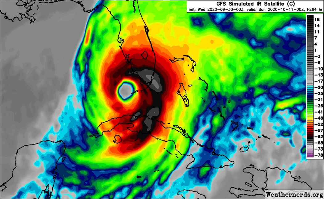
Wow, that looks like an echo of Michael, very similar track and would strike the same area 2 years later, exact to the day according to this model.
0 likes
Georges '98, Irene '99, Frances '04, Jeanne '04, Katrina '05, Wilma '05, Gustav '08, Isaac '12, Matthew '16, Florence '18, Michael '18, Ian '22
-
toad strangler
- S2K Supporter
- Posts: 4546
- Joined: Sun Jul 28, 2013 3:09 pm
- Location: Earth
- Contact:
Re: Tropical Wave East of the Lesser Antilles
12z GEFS is pretty spread out for this system with the largest signal of tracks congregating around the N Gulf coast with a smaller group into the FL peninsula.
0 likes
My Weather Station
https://www.wunderground.com/dashboard/pws/KFLPORTS603
https://www.wunderground.com/dashboard/pws/KFLPORTS603
-
SFLcane

- S2K Supporter
- Posts: 10281
- Age: 48
- Joined: Sat Jun 05, 2010 1:44 pm
- Location: Lake Worth Florida
Re: Tropical Wave East of the Lesser Antilles
What will tonight bring lol I know I woke up to some wild stuff this morning. 
5 likes
-
Blown Away

- S2K Supporter
- Posts: 10253
- Joined: Wed May 26, 2004 6:17 am
Re: Tropical Wave East of the Lesser Antilles
 12z Euro... Our TW makes an appearance @144 hours and finishes with a weak 1010 low, but is more defined than previous runs...
0 likes
Hurricane Eye Experience: David 79, Irene 99, Frances 04, Jeanne 04, Wilma 05… Hurricane Brush Experience: Andrew 92, Erin 95, Floyd 99, Matthew 16, Irma 17, Ian 22, Nicole 22…
-
Blown Away
- S2K Supporter
- Posts: 10253
- Joined: Wed May 26, 2004 6:17 am
Re: Tropical Wave East of the Lesser Antilles

12z GFS... (2) Florida landfalls, Panhandle as Cat 2 and loops back in East Central Florida as a TS...
2 likes
Hurricane Eye Experience: David 79, Irene 99, Frances 04, Jeanne 04, Wilma 05… Hurricane Brush Experience: Andrew 92, Erin 95, Floyd 99, Matthew 16, Irma 17, Ian 22, Nicole 22…
-
northjaxpro

- S2K Supporter
- Posts: 8900
- Joined: Mon Sep 27, 2010 11:21 am
- Location: Jacksonville, FL
Re: Tropical Wave East of the Lesser Antilles
This vort I believe poses the greatest threat to Florida as we get into the week beginning Oct 4 (next week)
It already has a very vigorous mid-level signature. This system has my attèntion!
It already has a very vigorous mid-level signature. This system has my attèntion!
0 likes
NEVER, EVER SAY NEVER in the tropics and weather in general, and most importantly, with life itself!!
________________________________________________________________________________________
Fay 2008 Beryl 2012 Debby 2012 Colin 2016 Hermine 2016 Julia 2016 Matthew 2016 Irma 2017 Dorian 2019
________________________________________________________________________________________
Fay 2008 Beryl 2012 Debby 2012 Colin 2016 Hermine 2016 Julia 2016 Matthew 2016 Irma 2017 Dorian 2019
-
TheStormExpert
Re: Tropical Wave East of the Lesser Antilles
SFLcane wrote:What will tonight bring lol I know I woke up to some wild stuff this morning.
https://i.postimg.cc/brNXG48k/20-A18-C75-1-A11-4-C52-8968-684-BE53-CA301.jpg
Fortunately the runs since have trended much weaker and up into the panhandle.
0 likes
-
ElectricStorm

- Category 5
- Posts: 5146
- Age: 25
- Joined: Tue Aug 13, 2019 11:23 pm
- Location: Norman, OK
Re: Tropical Wave East of the Lesser Antilles
TheStormExpert wrote:SFLcane wrote:What will tonight bring lol I know I woke up to some wild stuff this morning.
https://i.postimg.cc/brNXG48k/20-A18-C75-1-A11-4-C52-8968-684-BE53-CA301.jpg
Fortunately the runs since have trended much weaker and up into the panhandle.
*Checks memory* *Finds early runs for Michael*
0 likes
B.S Meteorology, University of Oklahoma '25
Please refer to the NHC, NWS, or SPC for official information.
Please refer to the NHC, NWS, or SPC for official information.
-
Loveweather12
- Tropical Storm

- Posts: 136
- Joined: Thu Aug 20, 2020 2:37 pm
Re: Tropical Wave East of the Lesser Antilles
Doesn’t mean that’s what it’s going to do. Theirs more to hurricane forecasting than models that have been acting all year long. Hello somebody!
TheStormExpert wrote:SFLcane wrote:What will tonight bring lol I know I woke up to some wild stuff this morning.
https://i.postimg.cc/brNXG48k/20-A18-C75-1-A11-4-C52-8968-684-BE53-CA301.jpg
Fortunately the runs since have trended much weaker and up into the panhandle.
0 likes
-
TheStormExpert
Re: Tropical Wave East of the Lesser Antilles
Weather Dude wrote:TheStormExpert wrote:SFLcane wrote:What will tonight bring lol I know I woke up to some wild stuff this morning.
https://i.postimg.cc/brNXG48k/20-A18-C75-1-A11-4-C52-8968-684-BE53-CA301.jpg
Fortunately the runs since have trended much weaker and up into the panhandle.
*Checks memory* *Finds early runs for Michael*
18z has even trended weaker.
0 likes

Re: Tropical Wave East of the Lesser Antilles
I'm really not much to rely on models too far out. Especially when the future of this wave basically depends on the other wave and how it will interact with this wave (if it will).
There is a lot of variables at play. Expect several changes in the next runs. From non-development to a Cat 5, anything is possible for models to show at this point.
There is a lot of variables at play. Expect several changes in the next runs. From non-development to a Cat 5, anything is possible for models to show at this point.
0 likes

Re: Tropical Wave East of the Lesser Antilles
Blown Away wrote:https://i.imgur.com/IoP30Xf.gif
12z GFS... (2) Florida landfalls, Panhandle as Cat 2 and loops back in East Central Florida as a TS...
Wait lol, it's revving for landfall #3 back toward the panhandle! Now THATS Tropical weather stuff
0 likes
Andy D
(For official information, please refer to the NHC and NWS products.)
(For official information, please refer to the NHC and NWS products.)
-
cycloneye
- Admin
- Posts: 149459
- Age: 69
- Joined: Thu Oct 10, 2002 10:54 am
- Location: San Juan, Puerto Rico
Re: Tropical Wave East of the Lesser Antilles
Another tropical wave located a few hundred miles east of the Lesser
Antilles is producing widespread cloudiness and disorganized shower
activity. This disturbance is forecast to move westward during the
next several days where environmental conditions could become a
little more conducive for development over the central or western
Caribbean Sea by early next week.
* Formation chance through 48 hours...low...near 0 percent.
* Formation chance through 5 days...low...20 percent.

0 likes
Visit the Caribbean-Central America Weather Thread where you can find at first post web cams,radars
and observations from Caribbean basin members Click Here
and observations from Caribbean basin members Click Here
Who is online
Users browsing this forum: No registered users and 193 guests