Visible loop from Real Earth.
https://realearth.ssec.wisc.edu/?produc ... HyT53X_Kk#
Tropical wave midway between Africa and Lesser Antilles (Is Invest 93L)
Moderator: S2k Moderators
Forum rules

The posts in this forum are NOT official forecasts and should not be used as such. They are just the opinion of the poster and may or may not be backed by sound meteorological data. They are NOT endorsed by any professional institution or STORM2K. For official information, please refer to products from the National Hurricane Center and National Weather Service.
-
cycloneye

- Admin

- Posts: 149214
- Age: 69
- Joined: Thu Oct 10, 2002 10:54 am
- Location: San Juan, Puerto Rico
Re: Tropical wave midway between Africa and Lesser Antilles
2 likes
Visit the Caribbean-Central America Weather Thread where you can find at first post web cams,radars
and observations from Caribbean basin members Click Here
and observations from Caribbean basin members Click Here

Re: Tropical wave midway between Africa and Lesser Antilles
Are you freaking kidding me? Will it ever end? Never thought I would look forward to resuming a "normal" covid year lol.
0 likes
Alicia, Rita, Ike, Harvey and Beryl...moved to Splendora lol

Re: Tropical wave midway between Africa and Lesser Antilles
cycloneye wrote:Visible loop from Real Earth.
https://realearth.ssec.wisc.edu/?produc ... HyT53X_Kk#
This is a great close-up. Even more cool that I just discovered using this Satellite tool is that one can click their mouse on any position during the loop, and while still holding their finger down on the left mouse button..... can drag "up" (or in any direction that they want) and then leg go. This will actually allow the user to better center the entire disturbance within their monitor screen.
0 likes
Andy D
(For official information, please refer to the NHC and NWS products.)
(For official information, please refer to the NHC and NWS products.)
Re: Tropical wave midway between Africa and Lesser Antilles
There is a ton of vorticity with this wave and it is already beginning to slowly organize while briskly moving off to the west. The easterly trades strike me as unusually strong for October. The very idea of seeing the potential development of a westward moving tropical disturbance approaching the Lesser Antilles in mid October may not be unheard of but does strike me as quite uncommon. The idea of any MDR origin tropical wave organizing into a T.S. and potentially approach the W. Bahamas or Florida would be a "head-scratcher". Gonna have to dive into the 'ol Storm track history book to see if (or how many) other similar tracks might exist.
3 likes
Andy D
(For official information, please refer to the NHC and NWS products.)
(For official information, please refer to the NHC and NWS products.)
Re: Tropical wave midway between Africa and Lesser Antilles
I don't have much faith in any of the models properly forecasting explicit development but they're worth noting for sake of trends. For now, the 12Z GFS simply advances the 850mb vorticity to the southern Antilles around 96 hours and thereafter weakens the feature. Later in it's forecast cycle the disturbance shows up and appears to develop in the far W. Caribbean at around 240 hours. Oddly, it's the NAV-GEM that is most enthusiastic and show's the westward moving 1005 low approaching the Lesser Antilles at around 96 hrs. and begins to then move the disturbance toward the NW.
0 likes
Andy D
(For official information, please refer to the NHC and NWS products.)
(For official information, please refer to the NHC and NWS products.)
-
gatorcane

- S2K Supporter

- Posts: 23708
- Age: 48
- Joined: Sun Mar 13, 2005 3:54 pm
- Location: Boca Raton, FL
Re: Tropical wave midway between Africa and Lesser Antilles
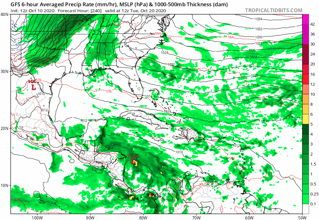
The GFS develops this in the SW Caribbean in the long-range and here is where it ends up:
2 likes
Re: Tropical wave midway between Africa and Lesser Antilles
gatorcane wrote:The GFS develops this in the SW Caribbean in the long-range and here is where it ends up:
https://i.postimg.cc/RZDWfq1c/gfs-mslp-pcpn-watl-fh240-378.gif
No offense to Florida, but I like that one. So some software models seem to be good for long term predictions and others for short term. Think we'll ever have one that does it all?
0 likes
Alicia, Rita, Ike, Harvey and Beryl...moved to Splendora lol
-
TheStormExpert
Re: Tropical wave midway between Africa and Lesser Antilles
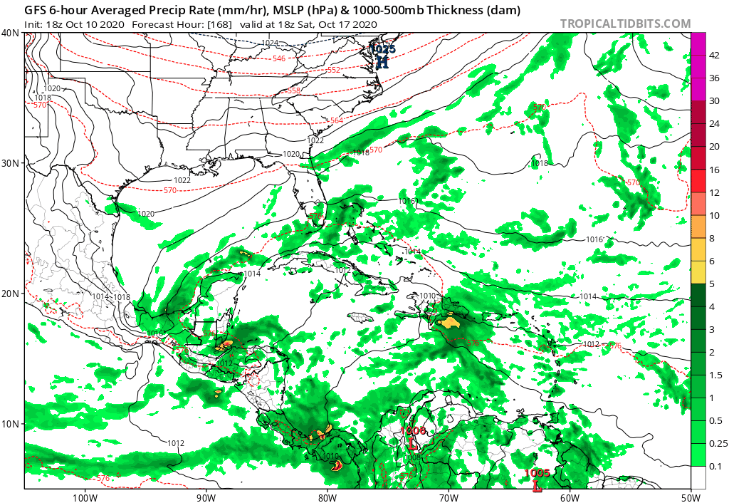
gatorcane wrote:The GFS develops this in the SW Caribbean in the long-range and here is where it ends up:
https://i.postimg.cc/RZDWfq1c/gfs-mslp-pcpn-watl-fh240-378.gif
A hurricane missing Florida to the south and east while ejecting NE from the Western Caribbean over Cuba and through the Central Bahamas seems reasonable. Especially if there’s a blocking ridge overhead.
0 likes
-
toad strangler

- S2K Supporter
- Posts: 4546
- Joined: Sun Jul 28, 2013 3:09 pm
- Location: Earth
- Contact:
Re: Tropical wave midway between Africa and Lesser Antilles
TheStormExpert wrote:gatorcane wrote:The GFS develops this in the SW Caribbean in the long-range and here is where it ends up:
https://i.postimg.cc/RZDWfq1c/gfs-mslp-pcpn-watl-fh240-378.gif
A hurricane missing Florida to the south and east while ejecting NE from the Western Caribbean over Cuba and through the Central Bahamas seems reasonable. Especially if there’s a blocking ridge overhead.
Of course it's reasonable. What isn't reasonable is taking long range specific track verbatim.
2 likes
My Weather Station
https://www.wunderground.com/dashboard/pws/KFLPORTS603
https://www.wunderground.com/dashboard/pws/KFLPORTS603
Re: Tropical wave midway between Africa and Lesser Antilles
TheStormExpert wrote:gatorcane wrote:The GFS develops this in the SW Caribbean in the long-range and here is where it ends up:
https://i.postimg.cc/RZDWfq1c/gfs-mslp-pcpn-watl-fh240-378.gif
A hurricane missing Florida to the south and east while ejecting NE from the Western Caribbean over Cuba and through the Central Bahamas seems reasonable. Especially if there’s a blocking ridge overhead.
That model depiction "is" reasonable. The track that Hurricane King took in 1950 striking Miami on Oct. 18 was also reasonable. Gauging any track to potentially hit or miss Florida at 378 hours is like throwing 100 darts and deciding which one looks best lol. I think the take away from this range is simply the signal that something might be brewing to our south with some projection of it potentially moving generally northward. This same scenario could very well play out but ultimately move a storm to the west, northwest, north, or northeast as many have done over the years. Therefore, any of those outcomes would also be "reasonable" depending on dynamic steering influences at that time. The only thing we DO know now about the steering at 378 hours...... is that we don't have a realistic clue what the steering flow will actually be from this range lol.
4 likes
Andy D
(For official information, please refer to the NHC and NWS products.)
(For official information, please refer to the NHC and NWS products.)
Re: Tropical wave midway between Africa and Lesser Antilles
Still in the formative stages however I can see a possible COC around 9.5N 39.3W. Whether this will remain dominant or another center forms to the north and east remains to be seen. The 2:00pm NHC tropical update has not come out yet but i'd guess that we'll see a significant ramp-up for projected development (perhaps 30/50?).
Edit: NHC updated their 2:00pm to still only show 10/20. Based on present convection and overall appearance, I'd have to think that'll be bumped up later this evening.
Edit: NHC updated their 2:00pm to still only show 10/20. Based on present convection and overall appearance, I'd have to think that'll be bumped up later this evening.
6 likes
Andy D
(For official information, please refer to the NHC and NWS products.)
(For official information, please refer to the NHC and NWS products.)
-
gatorcane
- S2K Supporter
- Posts: 23708
- Age: 48
- Joined: Sun Mar 13, 2005 3:54 pm
- Location: Boca Raton, FL
Re: Tropical wave midway between Africa and Lesser Antilles
Looks vigorous (see bottom-right corner of loop), if this makes it to the Western Caribbean lookout: 
0 likes
-
cycloneye
- Admin
- Posts: 149214
- Age: 69
- Joined: Thu Oct 10, 2002 10:54 am
- Location: San Juan, Puerto Rico
Re: Tropical wave midway between Africa and Lesser Antilles
Found this meme on social media. 

13 likes
Visit the Caribbean-Central America Weather Thread where you can find at first post web cams,radars
and observations from Caribbean basin members Click Here
and observations from Caribbean basin members Click Here
-
TheStormExpert
Re: Tropical wave midway between Africa and Lesser Antilles
0 likes
-
TheStormExpert
Re: Tropical wave midway between Africa and Lesser Antilles
So this is the catalyst that spawns development in nearly 10 days in the Western Caribbean?
0 likes
-
gatorcane
- S2K Supporter
- Posts: 23708
- Age: 48
- Joined: Sun Mar 13, 2005 3:54 pm
- Location: Boca Raton, FL
Re: Tropical wave midway between Africa and Lesser Antilles
TheStormExpert wrote::uarrow: Basically a sheared mess that gets quickly pulled NE over Central Cuba, The Bahamas and then OTS. Still a ways out so worth monitoring.
If this wave gets into the Western Caribbean into the area near Jamaica and south of Cuba, better hope that big-time front on the GFS is there to shear and steer this NE.
2 likes
-
TheStormExpert
Re: Tropical wave midway between Africa and Lesser Antilles
gatorcane wrote:TheStormExpert wrote::uarrow: Basically a sheared mess that gets quickly pulled NE over Central Cuba, The Bahamas and then OTS. Still a ways out so worth monitoring.
If this wave gets into the Western Caribbean into the area near Jamaica and south of Cuba, better hope that big-time front on the GFS is there to shear and steer this NE.
Well it depends where this system is when it gets into the Western Caribbean and when the trough comes.
Wilma was over the tip of the Yucatán when the trough came and pulled it NE across South Florida.
0 likes
-
gatorcane
- S2K Supporter
- Posts: 23708
- Age: 48
- Joined: Sun Mar 13, 2005 3:54 pm
- Location: Boca Raton, FL
Re: Tropical wave midway between Africa and Lesser Antilles
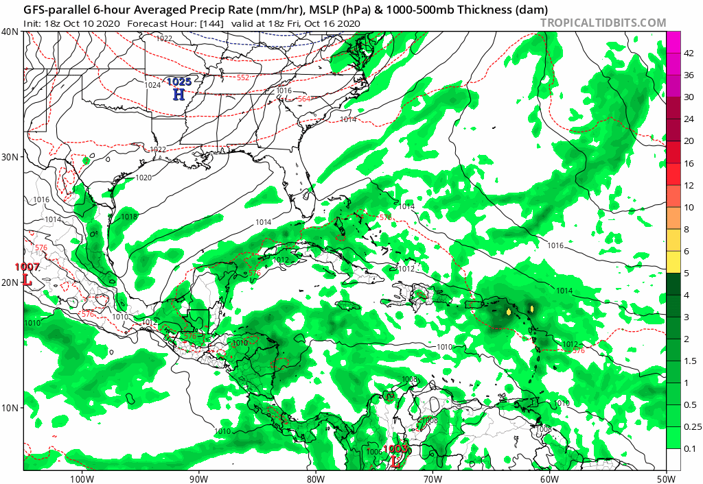
Missing frames but the long-range GFS parallel recurves north of the Greater Antilles but is also stronger:
Last edited by gatorcane on Sat Oct 10, 2020 7:59 pm, edited 1 time in total.
0 likes


Re: Tropical wave midway between Africa and Lesser Antilles
gatorcane wrote:Missing frames but the long-range GFS parallel recurves north is the Greater Antilles but is also stronger:
https://i.postimg.cc/MTYYwZY4/gfsp-mslp-pcpn-watl-fh144-300.gif
That’s the exact scenario I’ve been concerned about if the wave makes it north of the GAs. It would be a Bahamas threat, and could get uncomfortably close to the east coast.
0 likes
Irene '11 Sandy '12 Hermine '16 5/15/2018 Derecho Fay '20 Isaias '20 Elsa '21 Henri '21 Ida '21
I am only a meteorology enthusiast who knows a decent amount about tropical cyclones. Look to the professional mets, the NHC, or your local weather office for the best information.
I am only a meteorology enthusiast who knows a decent amount about tropical cyclones. Look to the professional mets, the NHC, or your local weather office for the best information.
Who is online
Users browsing this forum: No registered users and 82 guests