Possible Development in the Central / SW Caribbean (Is Invest 97L)

This is the general tropical discussion area. Anyone can take their shot at predicting a storms path.

Moderator: S2k Moderators

Forum rules

The posts in this forum are NOT official forecasts and should not be used as such. They are just the opinion of the poster and may or may not be backed by sound meteorological data. They are NOT endorsed by any professional institution or STORM2K. For official information, please refer to products from the National Hurricane Center and National Weather Service.

Help Support Storm2K
Message
Author
MarioProtVI
Category 2
Category 2
Posts: 675
Age: 23
Joined: Sun Sep 29, 2019 7:33 pm
Location: New Jersey

Re: Possible Development in the Central / SW Caribbean

#21 Postby MarioProtVI » Sun Oct 29, 2023 2:03 pm

cycloneye wrote:12z Euro operational has it moving to CentralAmerica as it has the ridge strong.

https://i.imgur.com/YIJ6ftB.gif

Anytime the Euro has this you have to watch out. I think Eta 2020 started out this way and I’m concerned this may try to emulate this. Of course we could also just end up with a Lisa repeat as well.
1 likes   

User avatar
Blown Away
S2K Supporter
S2K Supporter
Posts: 9874
Joined: Wed May 26, 2004 6:17 am

Re: Possible Development in the Central / SW Caribbean

#22 Postby Blown Away » Sun Oct 29, 2023 2:38 pm

Image
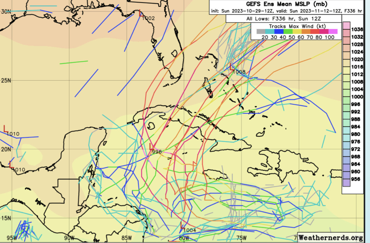
12z GEFS
0 likes   
Hurricane Eye Experience: David 79, Irene 99, Frances 04, Jeanne 04, Wilma 05... EYE COMING MY WAY IN 2024…
Hurricane Brush Experience: Andrew 92, Erin 95, Floyd 99, Matthew 16, Irma 17, Ian 22, Nicole 22…

User avatar
blp
Category 5
Category 5
Posts: 2807
Age: 45
Joined: Thu Sep 09, 2004 7:51 pm
Location: Miami, FL
Contact:

Re: Possible Development in the Central / SW Caribbean

#23 Postby blp » Sun Oct 29, 2023 3:06 pm

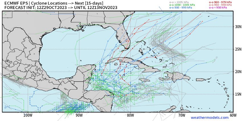
12z Euro ENS further North and stronger. Trend is North today. A little more and it will be all offshore. Very few members bury into C. America.

Image
2 likes   
The following post is NOT an official forecast and should not be used as such. It is just the opinion of the poster and may or may not be backed by sound meteorological data. It is NOT endorsed by any professional institution including storm2k.org For Official Information please refer to the NHC and NWS products.

User avatar
cycloneye
Admin
Admin
Posts: 139594
Age: 67
Joined: Thu Oct 10, 2002 10:54 am
Location: San Juan, Puerto Rico

Re: Possible Development in the Central / SW Caribbean

#24 Postby cycloneye » Sun Oct 29, 2023 3:15 pm

blp wrote:12z Euro ENS further North and stronger. Trend is North today. A little more and it will be all offshore. Very few members bury into C. America.

https://i.ibb.co/VYG4GjY/ecens-2023-10-29-12-Z-240-27-518-269-39-9-635-297-867-MSLP-Surface-tracks-lows.png


Yes blp.Trend at operational is also more north and a little bit stronger.

Image
0 likes   
Visit the Caribbean-Central America Weather Thread where you can find at first post web cams,radars
and observations from Caribbean basin members Click Here

User avatar
Hypercane_Kyle
Category 5
Category 5
Posts: 2902
Joined: Sat Mar 07, 2015 7:58 pm
Location: Cape Canaveral, FL

Re: Possible Development in the Central / SW Caribbean

#25 Postby Hypercane_Kyle » Sun Oct 29, 2023 3:51 pm

Development of something looks likely. Seems to me like a classic case of Euro-slow-to-catch-up, while the GFS is in happy hour.

Moderate TS/minimal hurricane in the Western Caribbean is my bet, with a landfall somewhere in Central America based on the steering currents.
0 likes   
My posts are my own personal opinion, defer to the National Hurricane Center (NHC) and other NOAA products for decision making during hurricane season.

User avatar
SFLcane
S2K Supporter
S2K Supporter
Posts: 9627
Age: 46
Joined: Sat Jun 05, 2010 1:44 pm
Location: Lake Worth Florida

Re: Possible Development in the Central / SW Caribbean

#26 Postby SFLcane » Sun Oct 29, 2023 4:36 pm

:eek:

Image
2 likes   

User avatar
Hypercane_Kyle
Category 5
Category 5
Posts: 2902
Joined: Sat Mar 07, 2015 7:58 pm
Location: Cape Canaveral, FL

Re: Possible Development in the Central / SW Caribbean

#27 Postby Hypercane_Kyle » Sun Oct 29, 2023 5:00 pm

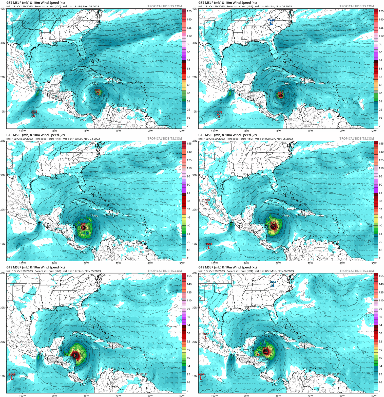
18z GFS considerably moving up the time frame for TC genesis, now has a tropical storm in the eastern Caribbean by Thursday morning.
1 likes   
My posts are my own personal opinion, defer to the National Hurricane Center (NHC) and other NOAA products for decision making during hurricane season.

User avatar
WalterWhite
Category 1
Category 1
Posts: 311
Joined: Fri Mar 17, 2023 5:53 pm

Re: Possible Development in the Central / SW Caribbean

#28 Postby WalterWhite » Sun Oct 29, 2023 5:02 pm

Hypercane_Kyle wrote:18z GFS considerably moving up the time frame for TC genesis, now has a tropical storm in the eastern Caribbean by Thursday morning.

You know what they say about 18Z GFS...
1 likes   

User avatar
cycloneye
Admin
Admin
Posts: 139594
Age: 67
Joined: Thu Oct 10, 2002 10:54 am
Location: San Juan, Puerto Rico

Re: Possible Development in the Central / SW Caribbean

#29 Postby cycloneye » Sun Oct 29, 2023 5:06 pm

Hypercane_Kyle wrote:18z GFS considerably moving up the time frame for TC genesis, now has a tropical storm in the eastern Caribbean by Thursday morning.


Let's see if the 00z run repeats that.
0 likes   
Visit the Caribbean-Central America Weather Thread where you can find at first post web cams,radars
and observations from Caribbean basin members Click Here

User avatar
SFLcane
S2K Supporter
S2K Supporter
Posts: 9627
Age: 46
Joined: Sat Jun 05, 2010 1:44 pm
Location: Lake Worth Florida

Re: Possible Development in the Central / SW Caribbean

#30 Postby SFLcane » Sun Oct 29, 2023 5:07 pm

WalterWhite wrote:
Hypercane_Kyle wrote:18z GFS considerably moving up the time frame for TC genesis, now has a tropical storm in the eastern Caribbean by Thursday morning.

You know what they say about 18Z GFS...


Yes they said the same thing about the 12z run lol. I think the gfs has the pegged just not sure about track or intensity yet.
0 likes   

User avatar
Hypercane_Kyle
Category 5
Category 5
Posts: 2902
Joined: Sat Mar 07, 2015 7:58 pm
Location: Cape Canaveral, FL

Re: Possible Development in the Central / SW Caribbean

#31 Postby Hypercane_Kyle » Sun Oct 29, 2023 5:14 pm

cycloneye wrote:
Hypercane_Kyle wrote:18z GFS considerably moving up the time frame for TC genesis, now has a tropical storm in the eastern Caribbean by Thursday morning.


Let's see if the 00z run repeats that.


Heading straight for nicaragua/honduras. Violent hurricane.
0 likes   
My posts are my own personal opinion, defer to the National Hurricane Center (NHC) and other NOAA products for decision making during hurricane season.

User avatar
SFLcane
S2K Supporter
S2K Supporter
Posts: 9627
Age: 46
Joined: Sat Jun 05, 2010 1:44 pm
Location: Lake Worth Florida

Re: Possible Development in the Central / SW Caribbean

#32 Postby SFLcane » Sun Oct 29, 2023 5:20 pm

Hypercane_Kyle wrote:
cycloneye wrote:
Hypercane_Kyle wrote:18z GFS considerably moving up the time frame for TC genesis, now has a tropical storm in the eastern Caribbean by Thursday morning.


Let's see if the 00z run repeats that.


Heading straight for nicaragua/honduras. Violent hurricane.


Nope turns north.
0 likes   

User avatar
Category5Kaiju
Category 5
Category 5
Posts: 3438
Age: 22
Joined: Thu Dec 24, 2020 12:45 pm
Location: Seattle

Re: Possible Development in the Central / SW Caribbean

#33 Postby Category5Kaiju » Sun Oct 29, 2023 5:20 pm

Hypercane_Kyle wrote:18z GFS considerably moving up the time frame for TC genesis, now has a tropical storm in the eastern Caribbean by Thursday morning.


That's because it seems to get its act together much quicker than the prior run.
0 likes   
Unless explicitly stated, all information covered in my posts is based on my opinions and observations. Please refer to a professional meteorologist or an accredited weather research agency otherwise, especially if serious decisions must be made in the event of a potentially life-threatening tropical storm or hurricane.

jlauderdal
S2K Supporter
S2K Supporter
Posts: 6810
Joined: Wed May 19, 2004 5:46 am
Location: NE Fort Lauderdale
Contact:

Re: Possible Development in the Central / SW Caribbean

#34 Postby jlauderdal » Sun Oct 29, 2023 5:21 pm

SFLcane wrote::eek:

Image
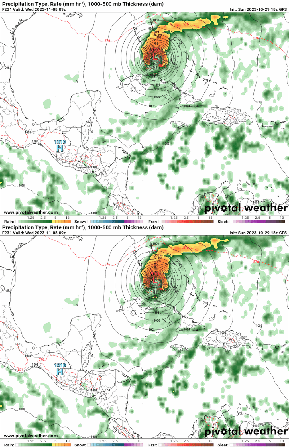
Increasing threat to sw fl
1 likes   

User avatar
cycloneye
Admin
Admin
Posts: 139594
Age: 67
Joined: Thu Oct 10, 2002 10:54 am
Location: San Juan, Puerto Rico

Re: Possible Development in the Central / SW Caribbean

#35 Postby cycloneye » Sun Oct 29, 2023 5:21 pm

Hypercane_Kyle wrote:
cycloneye wrote:
Hypercane_Kyle wrote:18z GFS considerably moving up the time frame for TC genesis, now has a tropical storm in the eastern Caribbean by Thursday morning.


Let's see if the 00z run repeats that.


Heading straight for nicaragua/honduras. Violent hurricane.


Lifted from coast of Honduras.


Image
0 likes   
Visit the Caribbean-Central America Weather Thread where you can find at first post web cams,radars
and observations from Caribbean basin members Click Here

User avatar
Blown Away
S2K Supporter
S2K Supporter
Posts: 9874
Joined: Wed May 26, 2004 6:17 am

Re: Possible Development in the Central / SW Caribbean

#36 Postby Blown Away » Sun Oct 29, 2023 5:24 pm

Image

18z GFS… MH making the N turn towards Cuba/SFL/Bahamas again…
2 likes   
Hurricane Eye Experience: David 79, Irene 99, Frances 04, Jeanne 04, Wilma 05... EYE COMING MY WAY IN 2024…
Hurricane Brush Experience: Andrew 92, Erin 95, Floyd 99, Matthew 16, Irma 17, Ian 22, Nicole 22…

User avatar
SFLcane
S2K Supporter
S2K Supporter
Posts: 9627
Age: 46
Joined: Sat Jun 05, 2010 1:44 pm
Location: Lake Worth Florida

Re: Possible Development in the Central / SW Caribbean

#37 Postby SFLcane » Sun Oct 29, 2023 5:39 pm

:eek:

Image
4 likes   

AutoPenalti
Category 5
Category 5
Posts: 3950
Age: 27
Joined: Mon Aug 17, 2015 4:16 pm
Location: Ft. Lauderdale, Florida

Re: Possible Development in the Central / SW Caribbean

#38 Postby AutoPenalti » Sun Oct 29, 2023 5:47 pm

What’s the water vapor like? Probably going to ingest a lot of continental dry air on approach…
0 likes   
The posts in this forum are NOT official forecasts and should not be used as such. They are just the opinion of the poster and may or may not be backed by sound meteorological data. They are NOT endorsed by any professional institution or STORM2K. For official information, please refer to products from the NHC and NWS.


Model Runs Cheat Sheet:
GFS (5:30 AM/PM, 11:30 AM/PM)
HWRF, GFDL, UKMET, NAVGEM (6:30-8:00 AM/PM, 12:30-2:00 AM/PM)
ECMWF (1:45 AM/PM)

TCVN
is a weighted averaged

User avatar
cycloneye
Admin
Admin
Posts: 139594
Age: 67
Joined: Thu Oct 10, 2002 10:54 am
Location: San Juan, Puerto Rico

Re: Possible Development in the Central / SW Caribbean

#39 Postby cycloneye » Sun Oct 29, 2023 5:48 pm

If what GFS has comes to fructition, the ACE will reach hyperactive status. Is right now at 145,6 and the 1.59 units is the number to reach and surpass.
3 likes   
Visit the Caribbean-Central America Weather Thread where you can find at first post web cams,radars
and observations from Caribbean basin members Click Here

User avatar
REDHurricane
Tropical Storm
Tropical Storm
Posts: 210
Age: 26
Joined: Sun Jul 03, 2022 2:36 pm
Location: Northeast Pacific Ocean

Re: Possible Development in the Central / SW Caribbean

#40 Postby REDHurricane » Sun Oct 29, 2023 6:28 pm

Category5Kaiju wrote:
Hypercane_Kyle wrote:18z GFS considerably moving up the time frame for TC genesis, now has a tropical storm in the eastern Caribbean by Thursday morning.


That's because it seems to get its act together much quicker than the prior run.


Yep, it looks like whether or not this setup produces a major hurricane will depend almost entirely on the initial consolidation of the disturbance -- if it develops into a TD more quickly like the GFS is predicting, we'll see another late-season Caribbean major that turns north towards Cuba/Florida instead of making landfall with Central America and weakening; if it forms more slowly like the Euro has been showing (but trending away from), we'll probably just get a weak TS that gets steered into Central America before it has a chance to intensify into anything of significance.

My hunch for the past several days has been that a strong hurricane will likely emerge out of this pattern. We've got all the ingredients: anomalously warm/deep water, favorable wind shear environment, large pocket of moisture without dry air intrusion, and a pre-existing disturbance moving into the area. It's almost November and the vast majority of the Caribbean is sitting at or above 30ºC... if the "purpose" of tropical cyclones on Earth is to transport anomalous heat from the tropics poleward and the sea surface upward, then I'd say this would be a perfect opportunity for the atmosphere to do exactly that before the season is over. Of course this doesn't mean anything has to develop for certain, but at this moment all of the ingredients required to cook up a major hurricane appear to be in place, and nature is about to stick the dish in a fully preheated oven -- whatever happens after that is up to chance.

Image

Image

Image
Last edited by REDHurricane on Sun Oct 29, 2023 6:34 pm, edited 1 time in total.
7 likes   


Return to “Talkin' Tropics”

Who is online

Users browsing this forum: Chris90, cycloneye, duilaslol, Stratton23 and 39 guests