170 knots based off FL reductions in the weaker quad and TDR data suggesting winds up to 15 knots stronger in the northeast.
~891 mbar works as peak pressure at 12z given it was 892 and rising shortly thereafter.
How strong was Hurricane Melissa 2025?
Moderator: S2k Moderators
Forum rules

The posts in this forum are NOT official forecasts and should not be used as such. They are just the opinion of the poster and may or may not be backed by sound meteorological data. They are NOT endorsed by any professional institution or STORM2K. For official information, please refer to products from the National Hurricane Center and National Weather Service.
-
Yellow Evan

- Professional-Met

- Posts: 16257
- Age: 27
- Joined: Fri Jul 15, 2011 12:48 pm
- Location: Henderson, Nevada/Honolulu, HI
- Contact:

Re: How strong was Hurricane Melissa 2025?
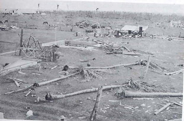
The wind damage I've seen from Melissa '25 is absolutely jaw-dropping. No question this is some of the worst wind-damage from an Atlantic landfall since 1935, definitely a high-end Cat 5 with winds over 175 mph.
Just unreal, images from various posts on X.


Just unreal, images from various posts on X.
2 likes
Georges '98, Irene '99, Frances '04, Jeanne '04, Katrina '05, Wilma '05, Gustav '08, Isaac '12, Matthew '16, Florence '18, Michael '18, Ian '22
-
Easterlywave

- Tropical Wave

- Posts: 3
- Age: 79
- Joined: Wed Oct 29, 2025 11:55 am
- Contact:
Re: How strong was Hurricane Melissa 2025?
FireRat wrote:The wind damage I've seen from Melissa '25 is absolutely jaw-dropping. No question this is some of the worst wind-damage from an Atlantic landfall since 1935, definitely a high-end Cat 5 with winds over 175 mph.
Just unreal, images from various posts on X.
https://i.ibb.co/k25RxL14/G5-ICQ0-WW8-AA4fj-G.jpg
Those images from Jamaica look like Hiroshima after atom bomb was dropped in1945. Also reminds me of reports of Hurricane Janet, 1955, where at least 175 mph winds (the anemometer blew away at that point) tore Chetumel, Mx apart. Janet flattened Swan Island shortly before that. The only recon. plane to be lost in the Atlantic happened in the W. Carib. and 914 pressure was recorded at one point. Below is Swan Island,
3 likes
A Pioneer of hurricane chasing: 1966---> Created the 1st. hurricane and storm chasing business ever: 1982. https://www.canebeard.com/hurricane_chaser.html
Re: How strong was Hurricane Melissa 2025?
Easterlywave wrote:FireRat wrote:The wind damage I've seen from Melissa '25 is absolutely jaw-dropping. No question this is some of the worst wind-damage from an Atlantic landfall since 1935, definitely a high-end Cat 5 with winds over 175 mph.
Just unreal, images from various posts on X.
https://i.ibb.co/k25RxL14/G5-ICQ0-WW8-AA4fj-G.jpg
Those images from Jamaica look like Hiroshima after atom bomb was dropped in1945. Also reminds me of reports of Hurricane Janet, 1955, where at least 175 mph winds (the anemometer blew away at that point) tore Chetumel, Mx apart. Janet flattened Swan Island shortly before that. The only recon. plane to be lost in the Atlantic happened in the W. Carib. and 914 pressure was recorded at one point. Below is Swan Island,
[url]https://i.postimg.cc/KzVHb5R8/swan-island.jpg [/url]
Wow! Janet was a beast!! Never seen such extreme damage from that storm before, certainly up there with the strongest landfalls of all time. Swan Island got flattened! Truly sad about that recon plane, nasty hurricane.
0 likes
Georges '98, Irene '99, Frances '04, Jeanne '04, Katrina '05, Wilma '05, Gustav '08, Isaac '12, Matthew '16, Florence '18, Michael '18, Ian '22

Re: How strong was Hurricane Melissa 2025?
Josh has released his long-awaited Hurricane Melissa report. One of his barometers recorded a minimum pressure of 926.0mb at 17:20z, placed at 18.0438N 77.9105W. His other three barometers bottomed out at 927.1-927.3mb.
https://static1.squarespace.com/static/ ... SA2025.pdf
Since recon provided us with the pressure gradient ahead of landfall, it shouldn’t be too difficult to work backwards towards the center using Josh’s measurement and determine the minimum landfall pressure. Since I don’t have that pressure gradient data, for now I’ve focused on obtaining more precise estimates of Melissa’s position and distance from Josh’s barometer. I used Google Maps with his most zoomed-in map as reference, but I may still be a few hundredths of a degree off with my estimates. This is what I get:
—17:00z: Melissa at 18.1000N/77.9968W, 5.95 nmi from Kestrel Meter No 936.
—17:20z: Melissa at 18.1331N/77.9968W, 7.18 nmi from Kestrel Meter No 936.
3 likes
Irene '11 Sandy '12 Hermine '16 5/15/2018 Derecho Fay '20 Isaias '20 Elsa '21 Henri '21 Ida '21
I am only a meteorology enthusiast who knows a decent amount about tropical cyclones. Look to the professional mets, the NHC, or your local weather office for the best information.
I am only a meteorology enthusiast who knows a decent amount about tropical cyclones. Look to the professional mets, the NHC, or your local weather office for the best information.
-
MarioProtVI
- Category 5

- Posts: 1038
- Age: 24
- Joined: Sun Sep 29, 2019 7:33 pm
- Location: New Jersey
Re: How strong was Hurricane Melissa 2025?
aspen wrote:Josh has released his long-awaited Hurricane Melissa report. One of his barometers recorded a minimum pressure of 926.0mb at 17:20z, placed at 18.0438N 77.9105W. His other three barometers bottomed out at 927.1-927.3mb.
https://static1.squarespace.com/static/ ... SA2025.pdf
Since recon provided us with the pressure gradient ahead of landfall, it shouldn’t be too difficult to work backwards towards the center using Josh’s measurement and determine the minimum landfall pressure. Since I don’t have that pressure gradient data, for now I’ve focused on obtaining more precise estimates of Melissa’s position and distance from Josh’s barometer. I used Google Maps with his most zoomed-in map as reference, but I may still be a few hundredths of a degree off with my estimates. This is what I get:
—17:00z: Melissa at 18.1000N/77.9968W, 5.95 nmi from Kestrel Meter No 936.
—17:20z: Melissa at 18.1331N/77.9968W, 7.18 nmi from Kestrel Meter No 936.
Using calculations, this gives out an estimated pressure of 905.8 mb. Given this, it definitely seems to confirm Melissa weakened some before landfall. Using this, and checking with CKZ, I would peg the landfall intensity at 150 kt / 906 mb. Lets see if NHC goes with this, as they have used Josh’s analysis many times before.
1 likes
Re: How strong was Hurricane Melissa 2025?
MarioProtVI wrote:aspen wrote:Josh has released his long-awaited Hurricane Melissa report. One of his barometers recorded a minimum pressure of 926.0mb at 17:20z, placed at 18.0438N 77.9105W. His other three barometers bottomed out at 927.1-927.3mb.
https://static1.squarespace.com/static/ ... SA2025.pdf
Since recon provided us with the pressure gradient ahead of landfall, it shouldn’t be too difficult to work backwards towards the center using Josh’s measurement and determine the minimum landfall pressure. Since I don’t have that pressure gradient data, for now I’ve focused on obtaining more precise estimates of Melissa’s position and distance from Josh’s barometer. I used Google Maps with his most zoomed-in map as reference, but I may still be a few hundredths of a degree off with my estimates. This is what I get:
—17:00z: Melissa at 18.1000N/77.9968W, 5.95 nmi from Kestrel Meter No 936.
—17:20z: Melissa at 18.1331N/77.9968W, 7.18 nmi from Kestrel Meter No 936.
Using calculations, this gives out an estimated pressure of 905.8 mb. Given this, it definitely seems to confirm Melissa weakened some before landfall. Using this, and checking with CKZ, I would peg the landfall intensity at 150 kt / 906 mb. Lets see if NHC goes with this, as they have used Josh’s analysis many times before.
That would be a 3-4 mb/hr filling rate if that holds up. A little higher than I would’ve expected, even with the warming convection in the inner CDO. The eye still maintained a good structure up to 1 hr before landfall.
I went back to the recon thread to see if I could compare Josh’s measurement with anything from AF or NOAA. The latter had the most consistent extrapolated measurements during its NW eyewall penetration. Using the data points at 13:44:30z (comparable pressure to Josh’s observations) and 13:46:30z (lowest FL winds, likely center), I got a pressure difference of 32.6mb (927.7mb to 895.1mb) across a distance of 0.086 degrees. At 17:00z, Josh was 0.103 degrees SE of Melissa’s center. So this might still support a sub-900 landfall if this comparison is adequate. What were the calculations you used to yield 905.8mb?
0 likes
Irene '11 Sandy '12 Hermine '16 5/15/2018 Derecho Fay '20 Isaias '20 Elsa '21 Henri '21 Ida '21
I am only a meteorology enthusiast who knows a decent amount about tropical cyclones. Look to the professional mets, the NHC, or your local weather office for the best information.
I am only a meteorology enthusiast who knows a decent amount about tropical cyclones. Look to the professional mets, the NHC, or your local weather office for the best information.
-
MarioProtVI
- Category 5
- Posts: 1038
- Age: 24
- Joined: Sun Sep 29, 2019 7:33 pm
- Location: New Jersey
Re: How strong was Hurricane Melissa 2025?
aspen wrote:MarioProtVI wrote:aspen wrote:Josh has released his long-awaited Hurricane Melissa report. One of his barometers recorded a minimum pressure of 926.0mb at 17:20z, placed at 18.0438N 77.9105W. His other three barometers bottomed out at 927.1-927.3mb.
https://static1.squarespace.com/static/ ... SA2025.pdf
Since recon provided us with the pressure gradient ahead of landfall, it shouldn’t be too difficult to work backwards towards the center using Josh’s measurement and determine the minimum landfall pressure. Since I don’t have that pressure gradient data, for now I’ve focused on obtaining more precise estimates of Melissa’s position and distance from Josh’s barometer. I used Google Maps with his most zoomed-in map as reference, but I may still be a few hundredths of a degree off with my estimates. This is what I get:
—17:00z: Melissa at 18.1000N/77.9968W, 5.95 nmi from Kestrel Meter No 936.
—17:20z: Melissa at 18.1331N/77.9968W, 7.18 nmi from Kestrel Meter No 936.
Using calculations, this gives out an estimated pressure of 905.8 mb. Given this, it definitely seems to confirm Melissa weakened some before landfall. Using this, and checking with CKZ, I would peg the landfall intensity at 150 kt / 906 mb. Lets see if NHC goes with this, as they have used Josh’s analysis many times before.
That would be a 3-4 mb/hr filling rate if that holds up. A little higher than I would’ve expected, even with the warming convection in the inner CDO. The eye still maintained a good structure up to 1 hr before landfall.
I went back to the recon thread to see if I could compare Josh’s measurement with anything from AF or NOAA. The latter had the most consistent extrapolated measurements during its NW eyewall penetration. Using the data points at 13:44:30z (comparable pressure to Josh’s observations) and 13:46:30z (lowest FL winds, likely center), I got a pressure difference of 32.6mb (927.7mb to 895.1mb) across a distance of 0.086 degrees. At 17:00z, Josh was 0.103 degrees SE of Melissa’s center. So this might still support a sub-900 landfall if this comparison is adequate. What were the calculations you used to yield 905.8mb?
926.0 mb, 5 mi distance, 8 nmi RMW, 1006 mb ROCI. Though I calculated that before Josh replied to someone saying the RMW was most likely 5 nmi. However I don’t believe 5 nmi works because that gives out 891 which is not representative at all. Hence, I think the true RMW was most likely 6 nmi, of which that gives out 899.8 or ~900 mb for a landfall. The monkey wrench seems to be how much was this following the only trend we saw before landfall, as we only had two fixes, that being 892 at 1302z and 894 at 1346z, which suggests ~3 mb/hr filling rate until landfall at 17z, which would be around roughly ~903 mb. It really sucks that we couldn’t get constant recon up until just before landfall so we’d have a better grasp on how much it filled into landfall, given NHC only kept 160 kt/892 mb at landfall for continuity purposes it seems (which is fine, just makes the post analysis a headache).
3 likes
-
ncforecaster89
- Category 1

- Posts: 269
- Age: 55
- Joined: Sat Oct 20, 2018 12:32 pm
- Contact:
Re: How strong was Hurricane Melissa 2025?
MarioProtVI wrote:aspen wrote:MarioProtVI wrote:Using calculations, this gives out an estimated pressure of 905.8 mb. Given this, it definitely seems to confirm Melissa weakened some before landfall. Using this, and checking with CKZ, I would peg the landfall intensity at 150 kt / 906 mb. Lets see if NHC goes with this, as they have used Josh’s analysis many times before.
That would be a 3-4 mb/hr filling rate if that holds up. A little higher than I would’ve expected, even with the warming convection in the inner CDO. The eye still maintained a good structure up to 1 hr before landfall.
I went back to the recon thread to see if I could compare Josh’s measurement with anything from AF or NOAA. The latter had the most consistent extrapolated measurements during its NW eyewall penetration. Using the data points at 13:44:30z (comparable pressure to Josh’s observations) and 13:46:30z (lowest FL winds, likely center), I got a pressure difference of 32.6mb (927.7mb to 895.1mb) across a distance of 0.086 degrees. At 17:00z, Josh was 0.103 degrees SE of Melissa’s center. So this might still support a sub-900 landfall if this comparison is adequate. What were the calculations you used to yield 905.8mb?
926.0 mb, 5 mi distance, 8 nmi RMW, 1006 mb ROCI. Though I calculated that before Josh replied to someone saying the RMW was most likely 5 nmi. However I don’t believe 5 nmi works because that gives out 891 which is not representative at all. Hence, I think the true RMW was most likely 6 nmi, of which that gives out 899.8 or ~900 mb for a landfall. The monkey wrench seems to be how much was this following the only trend we saw before landfall, as we only had two fixes, that being 892 at 1302z and 894 at 1346z, which suggests ~3 mb/hr filling rate until landfall at 17z, which would be around roughly ~903 mb. It really sucks that we couldn’t get constant recon up until just before landfall so we’d have a better grasp on how much it filled into landfall, given NHC only kept 160 kt/892 mb at landfall for continuity purposes it seems (which is fine, just makes the post analysis a headache).
I completely agree with your intensity estimate. Given there weren’t any further reconnaissance observations following the 1346z center fix, it’s going to be a little more subjective than any of us would like, unfortunately.
The Objective Data:
1) There was a 2 mb rise in the central pressure between the last two reconnaissance center fixes. Simple extrapolation would equate to an estimate of 903 mb at landfall (17z).
2) Josh measured a pressure of 926 mb at 1720z inside the RMW, and right at the edge of the SE portion of the eye (light rain and winds well below hurricane force).
3) Since there were no additional RECON observations after 1350z, we are left with a less definitive answer as to the precise RMW at 17z. Having said that, the RMW was 8 n mi at the last center fix. Prior to that time, there was a SAR pass at 11:10z that calculated a RMW of 7 n mi.
4) There was substantial degradation of the infrared satellite presentation following the aforementioned last RECON mission…consisting of significantly warming CDO convection (especially in the eyewall region) and an increasingly less defined eye structure.
The scholoemer equation has a pressure of 905.6 mb using the 8 n mi RMW and Josh’s distance from the center of the eye. That would equate to 900 mb for a RMW of 7 n mi.
Taking all these data into account, I’d set the 17z landfall intensity at a possibly generous 155 kt/903 mb.
As mentioned previously, nothing’s changed regarding my estimate of 165 kt/890 mb for Melissa’s peak intensity at 12z.
Last edited by ncforecaster89 on Tue Nov 18, 2025 5:24 am, edited 2 times in total.
0 likes
-
CrazyC83
- Professional-Met
- Posts: 34316
- Joined: Tue Mar 07, 2006 11:57 pm
- Location: Deep South, for the first time!
Re: How strong was Hurricane Melissa 2025?
The known data are pressures of 892 mb at 1302Z and 894 mb at 1346Z. There is a bit of uncertainty as the planes were struggling (and quickly turned around), however, the satellite estimates line up with a peak around that time or slightly earlier. It all seems to support 892 mb around 1400Z as a peak intensity.
Could it be possible that Melissa peaked a bit earlier, say 1200Z, with a pressure around 890 mb? The last penetration before then was around 0530Z with 900 mb. However, that is not supported by the deepening rates between 1800Z and 0600Z the previous day - it would represent a slight acceleration when satellite data didn't necessarily suggest such.
From what I could tell, he was probably 6 nm from the eye center at the time of landfall, and the RMW was likely 8 nm and the Daily Weather Map should the OCI at 1008 mb. I tried the Schloemer equation, using 897 mb as a central pressure, and got 926 mb for a value at his location. That lines up perfectly with my assessment of a landfall pressure of 897 mb.
1 likes
-
ncforecaster89
- Category 1
- Posts: 269
- Age: 55
- Joined: Sat Oct 20, 2018 12:32 pm
- Contact:
Re: How strong was Hurricane Melissa 2025?
CrazyC83 wrote:The known data are pressures of 892 mb at 1302Z and 894 mb at 1346Z. There is a bit of uncertainty as the planes were struggling (and quickly turned around), however, the satellite estimates line up with a peak around that time or slightly earlier. It all seems to support 892 mb around 1400Z as a peak intensity.
Could it be possible that Melissa peaked a bit earlier, say 1200Z, with a pressure around 890 mb? The last penetration before then was around 0530Z with 900 mb. However, that is not supported by the deepening rates between 1800Z and 0600Z the previous day - it would represent a slight acceleration when satellite data didn't necessarily suggest such.
From what I could tell, he was probably 6 nm from the eye center at the time of landfall, and the RMW was likely 8 nm and the Daily Weather Map should the OCI at 1008 mb. I tried the Schloemer equation, using 897 mb as a central pressure, and got 926 mb for a value at his location. That lines up perfectly with my assessment of a landfall pressure of 897 mb.
With the objective reconnaissance data showing a 894 mb pressure at 1346z and it having been an increase from the earlier 1302z center fix of 892 mb, I’m genuinely confused as to how you come to an estimate of 892 mb at 14z?
Without that second center fix, I could buy an 897 mb estimate of the central pressure at landfall, but given it was already 894 mb at 1346z, it’s inconceivable to me to assume the pressure *only* rose another 3 mb during those last 3.25 hours prior to landfall given the continually degrading satellite presentation, thereafter.
I can accept a 900 mb estimate, but anything lower just doesn’t objectively match the available data and corresponding observations, in my opinion. Even so, it’s really a relatively small difference in our assessments and I genuinely respect your own personal opinion on the subject, regardless.
3 likes
Re: How strong was Hurricane Melissa 2025?
MarioProtVI wrote:aspen wrote:MarioProtVI wrote:Using calculations, this gives out an estimated pressure of 905.8 mb. Given this, it definitely seems to confirm Melissa weakened some before landfall. Using this, and checking with CKZ, I would peg the landfall intensity at 150 kt / 906 mb. Lets see if NHC goes with this, as they have used Josh’s analysis many times before.
That would be a 3-4 mb/hr filling rate if that holds up. A little higher than I would’ve expected, even with the warming convection in the inner CDO. The eye still maintained a good structure up to 1 hr before landfall.
I went back to the recon thread to see if I could compare Josh’s measurement with anything from AF or NOAA. The latter had the most consistent extrapolated measurements during its NW eyewall penetration. Using the data points at 13:44:30z (comparable pressure to Josh’s observations) and 13:46:30z (lowest FL winds, likely center), I got a pressure difference of 32.6mb (927.7mb to 895.1mb) across a distance of 0.086 degrees. At 17:00z, Josh was 0.103 degrees SE of Melissa’s center. So this might still support a sub-900 landfall if this comparison is adequate. What were the calculations you used to yield 905.8mb?
926.0 mb, 5 mi distance, 8 nmi RMW, 1006 mb ROCI. Though I calculated that before Josh replied to someone saying the RMW was most likely 5 nmi. However I don’t believe 5 nmi works because that gives out 891 which is not representative at all. Hence, I think the true RMW was most likely 6 nmi, of which that gives out 899.8 or ~900 mb for a landfall. The monkey wrench seems to be how much was this following the only trend we saw before landfall, as we only had two fixes, that being 892 at 1302z and 894 at 1346z, which suggests ~3 mb/hr filling rate until landfall at 17z, which would be around roughly ~903 mb. It really sucks that we couldn’t get constant recon up until just before landfall so we’d have a better grasp on how much it filled into landfall, given NHC only kept 160 kt/892 mb at landfall for continuity purposes it seems (which is fine, just makes the post analysis a headache).
I think it was for the best recon left when it did. Turbulence during AF’s eyewall penetration was so bad that it would have been a significant safety risk if either plane went for the max winds (likely in the E eyewall according to TDR). Not even mentioning the increasing proximity to land. Really the main issue was Melissa’s sudden W jog that made the exact center miss Josh’s equipment, otherwise we would’ve gotten direct measurements of the true landfall pressure and post-analysis would’ve been a little less of a headache. Although a second NOAA pass would have helped clarify any trends in pressure changes ahead of landfall.
After looking through the extrapolated data from NOAA and AF, I’m unsure if the 894mb drop from NOAA is actually representative of a steady ~2 mb/hr filling rate beginning around 13z, or if it was a minor fluctuation before consistent filling began around 15z or so. Both planes yielded similar extrapolated pressures that fluctuated by several mbar and bottomed out between 892.0-892.5mb, and degradation to the inner CDO wasn’t noticeable until 15:00-15:30z. If the 2mb difference between the AF and NOAA drops was just a fluctuation prior to a filling phase, then the 897-899mb landfall estimates using 6nmi RMW seem to be quite plausible. If it was part of steady filling, then 903-906mb looks likely in my opinion.
8 likes
Irene '11 Sandy '12 Hermine '16 5/15/2018 Derecho Fay '20 Isaias '20 Elsa '21 Henri '21 Ida '21
I am only a meteorology enthusiast who knows a decent amount about tropical cyclones. Look to the professional mets, the NHC, or your local weather office for the best information.
I am only a meteorology enthusiast who knows a decent amount about tropical cyclones. Look to the professional mets, the NHC, or your local weather office for the best information.
-
CrazyC83
- Professional-Met
- Posts: 34316
- Joined: Tue Mar 07, 2006 11:57 pm
- Location: Deep South, for the first time!
Re: How strong was Hurricane Melissa 2025?
I was going with the satellite presentation as well, which seemed to peak in the 13Z-14Z period when the combination of eye temperature and cloud tops was greatest (there were slightly colder cloud tops earlier, but with the eye not quite as warm). Additionally, when you get such intense hurricanes, slight fluctuations in the pressure are common - the previous Recon set went 906, 906, 909, 905, 903, 900, 901. Based on those, I would estimate the pressure at 18Z was 906 mb (in line with that first reading), at 00Z was 905 mb (thinking the 909 was a fluctuation and perhaps a slight miss) and 06Z was 900 mb (in line with the last readings). There was no Recon between about 0545Z and 1245Z, which adds uncertainty.
This is certainly challenging to say the least...we have 2 pieces of data but we still have to deduce our way to the analysis since one piece requires using satellite estimates to extrapolate, while the other requires the Schloemer equation.
This is certainly challenging to say the least...we have 2 pieces of data but we still have to deduce our way to the analysis since one piece requires using satellite estimates to extrapolate, while the other requires the Schloemer equation.
5 likes
-
galaxy401

- Category 5
- Posts: 2446
- Age: 30
- Joined: Sat Aug 25, 2012 9:04 pm
- Location: Casa Grande, Arizona
Re: How strong was Hurricane Melissa 2025?
https://bnonews.com/index.php/2025/11/hurricane-melissa-registered-252-mph-wind-breaking-global-record/
A recon dropsonde recorded the strongest wind ever observed in a tropical cyclone: 252 mph! It's a gust but this could play a vital role in determining Melissa's true intensity.
A recon dropsonde recorded the strongest wind ever observed in a tropical cyclone: 252 mph! It's a gust but this could play a vital role in determining Melissa's true intensity.
4 likes
Got my eyes on moving right into Hurricane Alley: Florida.
-
cycloneye

- Admin

- Posts: 149686
- Age: 69
- Joined: Thu Oct 10, 2002 10:54 am
- Location: San Juan, Puerto Rico
Re: How strong was Hurricane Melissa 2025?
Andy was on that historic mission.
https://x.com/AndyHazelton/status/1991223843734843853
https://x.com/AndyHazelton/status/1991308741740806169
https://x.com/AndyHazelton/status/1991223843734843853
https://x.com/AndyHazelton/status/1991308741740806169
2 likes
Visit the Caribbean-Central America Weather Thread where you can find at first post web cams,radars
and observations from Caribbean basin members Click Here
and observations from Caribbean basin members Click Here
-
ncforecaster89
- Category 1
- Posts: 269
- Age: 55
- Joined: Sat Oct 20, 2018 12:32 pm
- Contact:
Re: How strong was Hurricane Melissa 2025?
Interestingly, if we use the scholemer equation with the following values: 935 mb, RMW of 8 n mi, distance of 8 n mi, and 1006 mb OCI…we get a central pressure of 894 mb. That’s precisely what RECON measured by dropsonde at 1346z.
Now, if we apply a station pressure of 926 mb, RMW of 8 n mi, distance of 5 n mi, and 1006 mb OCI…we get a central pressure of 906 mb. Change that distance to 6 n mi and it’s 897 mb. If one uses a distance of 5 n mi and a RMW of 7 n mi, it comes to 900 mb.
As can be seen, the scholemer equation is very sensitive to any small change to the RMW and/or the distance from the center.
As mentioned previously, simple extrapolation of the 2 mb filling rate between the last two center fixes (1302z & 1346z) would equate to 903 mb assuming no additional increase in the filling rate through landfall at 17z.
Given the fact Josh got into the edge of the eye where he encountered calming conditions…consisting of light rain and winds well below hurricane force…it’s virtually impossible to argue for a supposed 32 mb difference in the pressure at that specific time.
These calculations and in-situ data observations don’t even take into account the substantial degradation of the satellite presentation (most apparent in the eyewall region) that occurred beginning around 14z and becoming increasingly more significant, thereafter, especially beyond 1515z.
No matter what landfall intensity the NHC chooses to settle upon, it’s going to be a far more subjective determination than usual, unfortunately. The only things we can truly be sure of is that there was notable weakening that transpired following Melissa’s peak around 12-13z and that regardless of the specific intensity estimates, its landfall was still one of the strongest and most intense on record anywhere within the western hemisphere.
Based on all the available data, one could make a reasonable argument in support of a lowest central pressure anywhere in the range of 897 to 909 mb and 150 to 160 kt. I fall right in the middle of such estimates with a landfall at 155 kt/903 mb and seriously doubt it remained below 900 mb for the aforementioned reasons. Even so, I wouldn’t argue over 155 kt/899 mb whereby Melissa would secure sole possession of second place (ahead of Camille at 900 mb) on the list of *most intense* western hemisphere hurricane landfalls on record.
2 likes
-
Team Ghost
- Tropical Low

- Posts: 25
- Joined: Wed Nov 05, 2025 1:38 am
Re: How strong was Hurricane Melissa 2025?
galaxy401 wrote:https://bnonews.com/index.php/2025/11/hurricane-melissa-registered-252-mph-wind-breaking-global-record/
A recon dropsonde recorded the strongest wind ever observed in a tropical cyclone: 252 mph! It's a gust but this could play a vital role in determining Melissa's true intensity.
Typhoon Megi had a maximum recorded gust of 248 mph, yet the JTWC judged it as having a maximum sustained wind speed of 160 kt. This means that at most the NHC would settle for 165 kt for the peak intensity of Hurricane Melissa.
2 likes
-
ncforecaster89
- Category 1
- Posts: 269
- Age: 55
- Joined: Sat Oct 20, 2018 12:32 pm
- Contact:
Re: How strong was Hurricane Melissa 2025?
Team Ghost wrote:galaxy401 wrote:https://bnonews.com/index.php/2025/11/hurricane-melissa-registered-252-mph-wind-breaking-global-record/
A recon dropsonde recorded the strongest wind ever observed in a tropical cyclone: 252 mph! It's a gust but this could play a vital role in determining Melissa's true intensity.
Typhoon Megi had a maximum recorded gust of 248 mph, yet the JTWC judged it as having a maximum sustained wind speed of 160 kt. This means that at most the NHC would settle for 165 kt for the peak intensity of Hurricane Melissa.
Totally agree.
Although it’s an extremely impressive *instantaneous* wind gust measured well above the surface (250 meters), it doesn’t by itself support an increase in the maximum sustained one-minute wind speed at 10 meters elevation.
For instance, cyclone Olivia produced a measured 254 mph wind gust at a position 64 meters above the surface (sea-level) and at a 10 meter height above ground. Even so, the maximum sustained wind estimate was set at only 145 mph.
The far more relevant wind data derived from dropsondes are the WL150 (the average wind speed over the lowest 150 meters). In this case, it was 188 kt…which converts to a MSW of 156 kt at the surface using the appropriate reduction factor.
The main argument for a stronger intensity estimate is based on the assumption that stronger winds were located in the eastern portion of the eyewall that wasn’t sampled. That’s my main argument for an upward adjustment to the current operational MSW estimate of 160 kt (185 mph) to 165 kt (190 mph) at Melissa’s peak.
2 likes
Re: How strong was Hurricane Melissa 2025?
ncforecaster89 wrote:For instance, cyclone Olivia produced a measured 254 mph wind gust at a position 64 meters above the surface (sea-level) and at a 10 meter height above ground. Even so, the maximum sustained wind estimate was set at only 145 mph.
Since Olivia was an Australian cyclone, was that 145 mph a 10-minute sustained wind? If so, you'd have to apply some conversion factor to account for the different wind averaging period if you wish to use it as a guide for estimating the maximum sustained wind in Melissa from an elevated observed gust.
0 likes
-
ncforecaster89
- Category 1
- Posts: 269
- Age: 55
- Joined: Sat Oct 20, 2018 12:32 pm
- Contact:
Re: How strong was Hurricane Melissa 2025?
al78 wrote:ncforecaster89 wrote:For instance, cyclone Olivia produced a measured 254 mph wind gust at a position 64 meters above the surface (sea-level) and at a 10 meter height above ground. Even so, the maximum sustained wind estimate was set at only 145 mph.
Since Olivia was an Australian cyclone, was that 145 mph a 10-minute sustained wind? If so, you'd have to apply some conversion factor to account for the different wind averaging period if you wish to use it as a guide for estimating the maximum sustained wind in Melissa from an elevated observed gust.
The 125 kt (145 mph) MSW value is the official JTWC intensity estimate.
I was using it simply to note that the aforementioned 252 mph *instantaneous* wind gust at 250 meters elevation doesn’t translate to a higher MSW estimate in and of itself. It’s just one additional piece of data amongst many others. That said, it does further make clear that Melissa was a hurricane of a rare and historic intensity…especially for the NATL basin.
0 likes
Who is online
Users browsing this forum: No registered users and 175 guests