Gulf Coast Disturbance (early August)
Moderator: S2k Moderators
Forum rules

The posts in this forum are NOT official forecasts and should not be used as such. They are just the opinion of the poster and may or may not be backed by sound meteorological data. They are NOT endorsed by any professional institution or STORM2K. For official information, please refer to products from the National Hurricane Center and National Weather Service.
-
stormlover2013
Re: Northeastern Gulf of Mexico
This will be a very good rain maker!!! Be careful on the roads
0 likes
Re: Northeastern Gulf of Mexico
Flood watch for the nature coast with some eye popping rain estimates:
...FLOOD WATCH IN EFFECT THROUGH TUESDAY MORNING...
THE NATIONAL WEATHER SERVICE IN TAMPA BAY AREA - RUSKIN FL HAS
ISSUED A
* FLOOD WATCH FOR PORTIONS OF NORTHERN FLORIDA AND WEST CENTRAL
FLORIDA...INCLUDING THE FOLLOWING AREAS...IN NORTHERN
FLORIDA...COASTAL LEVY AND INLAND LEVY. IN WEST CENTRAL
FLORIDA...COASTAL CITRUS...COASTAL HERNANDO...COASTAL PASCO...
INLAND CITRUS...INLAND HERNANDO AND INLAND PASCO.
* THROUGH TUESDAY MORNING
* NUMEROUS TO WIDESPREAD SHOWERS AND SCATTERED THUNDERSTORMS ARE
ONGOING ACROSS THE NATURE COAST TODAY AND ARE EXPECTED TO
CONTINUE FOR THE NEXT FEW DAYS. CONDITIONS WILL BE SUPPORTIVE OF
LOCALLY HEAVY RAINFALL AMOUNTS OF 6 TO 10 INCHES...WITH 10 TO 15
INCHES POSSIBLE NEAR THE COAST AND LOCALLY HIGHER AMOUNTS
POSSIBLE.
0 likes
-
cycloneye

- Admin

- Posts: 149443
- Age: 69
- Joined: Thu Oct 10, 2002 10:54 am
- Location: San Juan, Puerto Rico
Re: Northeastern Gulf of Mexico
SSD has put up a Invest floater but ATCF has not designated it as Invest98L.

http://www.ssd.noaa.gov/PS/TROP/floater ... oater.html
ftp://ftp.nhc.noaa.gov/atcf/btk/
ftp://ftp.nhc.noaa.gov/atcf/
http://www.ssd.noaa.gov/PS/TROP/floater ... oater.html
ftp://ftp.nhc.noaa.gov/atcf/btk/
ftp://ftp.nhc.noaa.gov/atcf/
0 likes
Visit the Caribbean-Central America Weather Thread where you can find at first post web cams,radars
and observations from Caribbean basin members Click Here
and observations from Caribbean basin members Click Here
-
tropicwatch

- Category 5

- Posts: 3426
- Age: 62
- Joined: Sat Jun 02, 2007 10:01 am
- Location: The Villages, Florida
- Contact:
Re: Northeastern Gulf of Mexico
I imagine some warnings will be going up for Franklin County. Apalachicola has got the rain train going on right now. North to south of course. 
1 likes
Tropicwatch
Agnes 72', Eloise 75, Elena 85', Kate 85', Charley 86', Florence 88', Beryl 94', Dean 95', Erin 95', Opal 95', Earl 98', Georges 98', Ivan 2004', Arlene 2005', Dennis 2005', Ida 2009' Debby 2012' Irma 2017' Michael 2018'
Agnes 72', Eloise 75, Elena 85', Kate 85', Charley 86', Florence 88', Beryl 94', Dean 95', Erin 95', Opal 95', Earl 98', Georges 98', Ivan 2004', Arlene 2005', Dennis 2005', Ida 2009' Debby 2012' Irma 2017' Michael 2018'
-
Ivanhater

- Storm2k Moderator

- Posts: 11221
- Age: 39
- Joined: Fri Jul 01, 2005 8:25 am
- Location: Pensacola
Re: Northeastern Gulf of Mexico
This will slide west along the northern gulf coast. Insane rain totals expected along the northern gulf coast
1 likes
Michael

-
Dean4Storms
- S2K Supporter

- Posts: 6358
- Age: 63
- Joined: Sun Aug 31, 2003 1:01 pm
- Location: Miramar Bch. FL
Re: Northeastern Gulf of Mexico
Well even if this did get tagged a TC it looks like it would never be much more than a heavy rain threat with maybe some gales as it is just to close to land.
With all the models abandoning TC development I can see why the NHC lowered the chance.
With all the models abandoning TC development I can see why the NHC lowered the chance.
0 likes
-
floridasun78
- Category 5
- Posts: 3755
- Joined: Sun May 17, 2009 10:16 pm
- Location: miami fl
Re: Northeastern Gulf of Mexico
Dean4Storms wrote:Well even if this did get tagged a TC it looks like it would never be much more than a heavy rain threat with maybe some gales as it is just to close to land.
With all the models abandoning TC development I can see why the NHC lowered the chance.
i see more of any thing as rainy maker ((The posts in this forum are NOT official forecast and should not be used as such.))
0 likes

Re: Northeastern Gulf of Mexico
Looking a little better this afternoon and looks to become a huge rainmaker event along the N and NE GOM. Thankfully its not well offshore in the GOM and remains close to land.
0 likes
The following post is NOT an official forecast and should not be used as such. It is just the opinion of the poster and may or may not be backed by sound meteorological data. It is NOT endorsed by any professional institution including storm2k.org For Official Information please refer to the NHC and NWS products.
-
Dean4Storms
- S2K Supporter
- Posts: 6358
- Age: 63
- Joined: Sun Aug 31, 2003 1:01 pm
- Location: Miramar Bch. FL
Re: Northeastern Gulf of Mexico
It looks like the center of the Vort is now inland maybe near Perry, FL at some point it is expected to turn back westward and looks like it stays inland if it does so.
The posts in this forum are NOT official forecasts and should not be used as such. They are just the opinion of the poster and may or may not be backed by sound meteorological data. They are NOT endorsed by any professional institution or STORM2K. For official information, please refer to products from the NHC and NWS.
0 likes

Re: Northeastern Gulf of Mexico
rolltide wrote:Ivanhater wrote:This will slide west along the northern gulf coast. Insane rain totals expected along the northern gulf coast
Come on Michael, You should know to post the disclaimer
Ummm.....
viewtopic.php?f=37&p=2511428#p2511428
2 likes

Re: Northeastern Gulf of Mexico
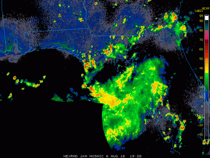
Circulation is not at the surface yet per surface reports, pressures have fallen a little during the past 24-48 hrs but still fairly high. Big outflow boundary went through Tampa before the squall line came through thus the squall died out, same thing here in Orlando.
0 likes
-
Aric Dunn
- Category 5
- Posts: 21238
- Age: 43
- Joined: Sun Sep 19, 2004 9:58 pm
- Location: Ready for the Chase.
- Contact:
Re: Northeastern Gulf of Mexico
NDG wrote:Circulation is not at the surface yet per surface reports, pressures have fallen a little during the past 24-48 hrs but still fairly high. Big outflow boundary went through Tampa before the squall line came through thus the squall died out, same thing here in Orlando.
[img]http://i20.photobucket.com/albums/b245/ndgarcia/ndgarcia067/CODNEXLAB-1km-Florida-rad-ani24-201608062115-100-100-raw_zpsxqgsdfms.gif[/mg]
The surface circ is there just very broad and elongated so looking at radar from multiple site and at different level in the atmosphere will make such a not stacked system look really disorganized( which is still but getting better)
0 likes
Note: If I make a post that is brief. Please refer back to previous posts for the analysis or reasoning. I do not re-write/qoute what my initial post said each time.
If there is nothing before... then just ask
Space & Atmospheric Physicist, Embry-Riddle Aeronautical University,
I believe the sky is falling...
If there is nothing before... then just ask
Space & Atmospheric Physicist, Embry-Riddle Aeronautical University,
I believe the sky is falling...
Re: Northeastern Gulf of Mexico
Aric Dunn wrote:NDG wrote:Circulation is not at the surface yet per surface reports, pressures have fallen a little during the past 24-48 hrs but still fairly high. Big outflow boundary went through Tampa before the squall line came through thus the squall died out, same thing here in Orlando.
[img]http://i20.photobucket.com/albums/b245/ndgarcia/ndgarcia067/CODNEXLAB-1km-Florida-rad-ani24-201608062115-100-100-raw_zpsxqgsdfms.gif[/mg]
The surface circ is there just very broad and elongated so looking at radar from multiple site and at different level in the atmosphere will make such a not stacked system look really disorganized( which is still but getting better)
All the outflows including along the FL Panhandle to the big bend area is a good indication that the circulation is above the surface at the moment. IMO.
0 likes
-
tolakram
- Admin
- Posts: 20185
- Age: 62
- Joined: Sun Aug 27, 2006 8:23 pm
- Location: Florence, KY (name is Mark)
Re: Northeastern Gulf of Mexico
rolltide wrote:Ivanhater wrote:This will slide west along the northern gulf coast. Insane rain totals expected along the northern gulf coast
Come on Michael, You should know to post the disclaimer
Disclaimer is no longer required, there's a sticky post updating the rule.
0 likes
M a r k
- - - - -
Join us in chat: Storm2K Chatroom Invite. Android and IOS apps also available.
The posts in this forum are NOT official forecasts and should not be used as such. Posts are NOT endorsed by any professional institution or STORM2K.org. For official information and forecasts, please refer to NHC and NWS products.
-
northjaxpro

- S2K Supporter
- Posts: 8900
- Joined: Mon Sep 27, 2010 11:21 am
- Location: Jacksonville, FL
Re: Northeastern Gulf of Mexico
NHC still has yet to officially classify this system as 98L. I wonder if they will finally do it or are they seeing that this system being too close to land will keep them from classifying this system?
1 likes
NEVER, EVER SAY NEVER in the tropics and weather in general, and most importantly, with life itself!!
________________________________________________________________________________________
Fay 2008 Beryl 2012 Debby 2012 Colin 2016 Hermine 2016 Julia 2016 Matthew 2016 Irma 2017 Dorian 2019
________________________________________________________________________________________
Fay 2008 Beryl 2012 Debby 2012 Colin 2016 Hermine 2016 Julia 2016 Matthew 2016 Irma 2017 Dorian 2019
-
Aric Dunn
- Category 5
- Posts: 21238
- Age: 43
- Joined: Sun Sep 19, 2004 9:58 pm
- Location: Ready for the Chase.
- Contact:
Re: Northeastern Gulf of Mexico
NDG wrote:Aric Dunn wrote:NDG wrote:Circulation is not at the surface yet per surface reports, pressures have fallen a little during the past 24-48 hrs but still fairly high. Big outflow boundary went through Tampa before the squall line came through thus the squall died out, same thing here in Orlando.
[img]http://i20.photobucket.com/albums/b245/ndgarcia/ndgarcia067/CODNEXLAB-1km-Florida-rad-ani24-201608062115-100-100-raw_zpsxqgsdfms.gif[/mg]
The surface circ is there just very broad and elongated so looking at radar from multiple site and at different level in the atmosphere will make such a not stacked system look really disorganized( which is still but getting better)
All the outflows including along the FL Panhandle to the big bend area is a good indication that the circulation is above the surface at the moment. IMO.
yeah this happens all the time when a system is forming near the coast. the sea breezes and constant collapsing of convection ( with outflow boundaries) always get brought up. right now the system is not organized enough to effect the sea breezes as they have more energy localized than the broad weak systems. not until the pressure can drop enough will that stop.
0 likes
Note: If I make a post that is brief. Please refer back to previous posts for the analysis or reasoning. I do not re-write/qoute what my initial post said each time.
If there is nothing before... then just ask
Space & Atmospheric Physicist, Embry-Riddle Aeronautical University,
I believe the sky is falling...
If there is nothing before... then just ask
Space & Atmospheric Physicist, Embry-Riddle Aeronautical University,
I believe the sky is falling...
Re: Northeastern Gulf of Mexico
Aric Dunn wrote:NDG wrote:Aric Dunn wrote:
The surface circ is there just very broad and elongated so looking at radar from multiple site and at different level in the atmosphere will make such a not stacked system look really disorganized( which is still but getting better)
All the outflows including along the FL Panhandle to the big bend area is a good indication that the circulation is above the surface at the moment. IMO.
yeah this happens all the time when a system is forming near the coast. the sea breezes and constant collapsing of convection ( with outflow boundaries) always get brought up. right now the system is not organized enough to effect the sea breezes as they have more energy localized than the broad weak systems. not until the pressure can drop enough will that stop.
I agree, it makes sense. Even on vis satellite loop it makes it look like we have rebust surface circulation but is not there yet.
0 likes
-
Aric Dunn
- Category 5
- Posts: 21238
- Age: 43
- Joined: Sun Sep 19, 2004 9:58 pm
- Location: Ready for the Chase.
- Contact:
Re: Northeastern Gulf of Mexico
NDG wrote:Aric Dunn wrote:
yeah this happens all the time when a system is forming near the coast. the sea breezes and constant collapsing of convection ( with outflow boundaries) always get brought up. right now the system is not organized enough to effect the sea breezes as they have more energy localized than the broad weak systems. not until the pressure can drop enough will that stop.
I agree, it makes sense. Even on vis satellite loop it makes it look like we have rebust surface circulation but is not there yet.
Typically what happens is during the day it looks like we lose the surface circ do to all the sea breezes and outflows. but its still there in a broad sense and during the night when the heat energy from the sun is gone and temperature gradient equalizes we see circulations become more defined again.
1 likes
Note: If I make a post that is brief. Please refer back to previous posts for the analysis or reasoning. I do not re-write/qoute what my initial post said each time.
If there is nothing before... then just ask
Space & Atmospheric Physicist, Embry-Riddle Aeronautical University,
I believe the sky is falling...
If there is nothing before... then just ask
Space & Atmospheric Physicist, Embry-Riddle Aeronautical University,
I believe the sky is falling...
-
CrazyC83
- Professional-Met

- Posts: 34315
- Joined: Tue Mar 07, 2006 11:57 pm
- Location: Deep South, for the first time!
Re: Northeastern Gulf of Mexico
Hopefully it gets classified as 98L or 99L soon just so that we can get more model runs...
0 likes
Who is online
Users browsing this forum: No registered users and 447 guests