Possible development in Western Caribbean - (Is INVEST 93L)

This is the general tropical discussion area. Anyone can take their shot at predicting a storms path.

Moderator: S2k Moderators

Forum rules

The posts in this forum are NOT official forecasts and should not be used as such. They are just the opinion of the poster and may or may not be backed by sound meteorological data. They are NOT endorsed by any professional institution or STORM2K. For official information, please refer to products from the National Hurricane Center and National Weather Service.

Help Support Storm2K
Message
Author
User avatar
cycloneye
Admin
Admin
Posts: 145285
Age: 68
Joined: Thu Oct 10, 2002 10:54 am
Location: San Juan, Puerto Rico

Re: Possible development in Western Caribbean

#201 Postby cycloneye » Thu Jun 15, 2017 6:42 pm

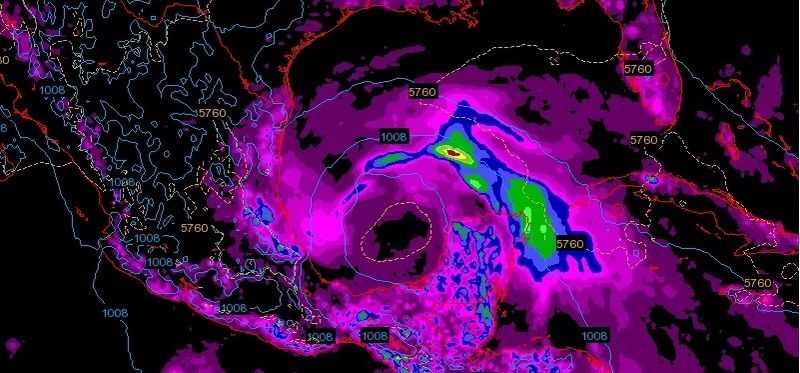
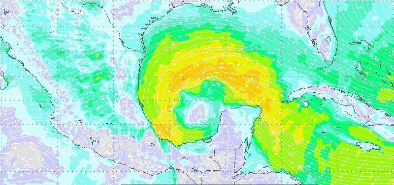
A broad area of low pressure is expected to form over the
northwestern Caribbean Sea and the Yucatan peninsula this
weekend. Conditions appear to be favorable for gradual development
of this system while it moves slowly northwestward toward the
southern Gulf of Mexico early next week.
* Formation chance through 48 hours...low...near 0 percent.
* Formation chance through 5 days...medium...50 percent
0 likes   
Visit the Caribbean-Central America Weather Thread where you can find at first post web cams,radars
and observations from Caribbean basin members Click Here

User avatar
South Texas Storms
Professional-Met
Professional-Met
Posts: 4224
Joined: Thu Jun 24, 2010 12:28 am
Location: Houston, TX

Re: Possible development in Western Caribbean

#202 Postby South Texas Storms » Thu Jun 15, 2017 6:54 pm

12z Euro Parallel has it moving inland just west of Galveston as a TS in 8 days (next Friday).
1 likes   

User avatar
ROCK
Category 5
Category 5
Posts: 9484
Age: 54
Joined: Tue Aug 17, 2004 7:30 am
Location: Kemah, Texas

Re: Possible development in Western Caribbean

#203 Postby ROCK » Thu Jun 15, 2017 7:23 pm

South Texas Storms wrote:12z Euro Parallel has it moving inland just west of Galveston as a TS in 8 days (next Friday).


Yep however IMO climo needs to be taken into account. It's June..smells like Mexico..to me..0z GFS or might shed some light..the Texas death ridge never breaks down this early.:)
0 likes   

User avatar
Dylan
Professional-Met
Professional-Met
Posts: 338
Age: 30
Joined: Mon May 31, 2010 9:50 am
Location: New Orleans, LA

Re: Possible development in Western Caribbean

#204 Postby Dylan » Thu Jun 15, 2017 7:28 pm

South Texas Storms wrote:12z Euro Parallel has it moving inland just west of Galveston as a TS in 8 days (next Friday).


Yep, and a very large tropical storm at that, with tropical storm force winds as far to the east as the Mouth of the Mississippi River, and very squally weather even in New Orleans. This is the type of scenario that would cause a lot of coastal flooding for Louisiana's marshes and estuaries.
2 likes   
Georges('98), Allison('01), Isidore('02), Lili('02), Frances('04) Ivan('04), Cindy('05), Katrina('05), Rita('05), Gustav('08), Isaac('12), Matthew('16), Harvey('17), Irma('17), Nate ('17), Ida ('21).

weatherguy425
Tropical Storm
Tropical Storm
Posts: 180
Joined: Sun Aug 16, 2009 1:06 pm
Location: Houston, TX > Lubbock, TX > Savannah, GA
Contact:

Re: Possible development in Western Caribbean

#205 Postby weatherguy425 » Thu Jun 15, 2017 7:31 pm

ROCK wrote:
South Texas Storms wrote:12z Euro Parallel has it moving inland just west of Galveston as a TS in 8 days (next Friday).


Yep however IMO climo needs to be taken into account. It's June..smells like Mexico..to me..0z GFS or might shed some light..the Texas death ridge never breaks down this early.:)


June climatology doesn't tarnish a TX landfall. Not saying that's the outcome here, but citing June tropical history actually doesn't refute it a landfall north of Mexico.
0 likes   

User avatar
ROCK
Category 5
Category 5
Posts: 9484
Age: 54
Joined: Tue Aug 17, 2004 7:30 am
Location: Kemah, Texas

Re: Possible development in Western Caribbean

#206 Postby ROCK » Thu Jun 15, 2017 7:33 pm

12z Navgem still won't budge on. FL panhandle scenario. Really blows it up. But it is the Nav.:)
1 likes   

User avatar
ROCK
Category 5
Category 5
Posts: 9484
Age: 54
Joined: Tue Aug 17, 2004 7:30 am
Location: Kemah, Texas

Re: Possible development in Western Caribbean

#207 Postby ROCK » Thu Jun 15, 2017 7:38 pm

weatherguy425 wrote:
ROCK wrote:
South Texas Storms wrote:12z Euro Parallel has it moving inland just west of Galveston as a TS in 8 days (next Friday).


Yep however IMO climo needs to be taken into account. It's June..smells like Mexico..to me..0z GFS or might shed some light..the Texas death ridge never breaks down this early.:)


June climatology doesn't tarnish a TX landfall. Not saying that's the outcome here, but citing June tropical history actually doesn't refute it a landfall north of Mexico.


True that's why I said in my opinion. Euro been sniffing MX for awhile. Only have one run of the Euro showing TX. Have to see at 230am CST tonight if it sticks with it or goes back to MX. If this was Late August or Sept I might chew on NGOM. :)
2 likes   

User avatar
cycloneye
Admin
Admin
Posts: 145285
Age: 68
Joined: Thu Oct 10, 2002 10:54 am
Location: San Juan, Puerto Rico

Re: Possible development in Western Caribbean

#208 Postby cycloneye » Thu Jun 15, 2017 7:51 pm

As always Levi does great videos and here is a new one about this future system.Duration is 10:30.

http://www.tropicaltidbits.com/blog/201 ... next-week/
0 likes   
Visit the Caribbean-Central America Weather Thread where you can find at first post web cams,radars
and observations from Caribbean basin members Click Here

BobHarlem
Category 5
Category 5
Posts: 2104
Joined: Thu Oct 20, 2005 6:11 pm

Re: Possible development in Western Caribbean

#209 Postby BobHarlem » Thu Jun 15, 2017 8:02 pm

ROCK wrote:12z Navgem still won't budge on. FL panhandle scenario. Really blows it up. But it is the Nav.:)


The wave currently off of the north coast of Columbia is the biggest reason I have doubts on the Euro, it's what this and the GFS seems to be grabbing also. That area is a huge mess right now, so I don't trust any of the models, to be honest.
2 likes   

User avatar
wxman57
Moderator-Pro Met
Moderator-Pro Met
Posts: 22978
Age: 67
Joined: Sat Jun 21, 2003 8:06 pm
Location: Houston, TX (southwest)

Re: Possible development in Western Caribbean

#210 Postby wxman57 » Thu Jun 15, 2017 8:22 pm

ROCK wrote:12z Navgem still won't budge on. FL panhandle scenario. Really blows it up. But it is the Nav.:)


Remember always add 180 degrees to the predicted direction of the storm in the NAVGEM model. If NAVGEM says east, for example, it's moving west.
8 likes   

User avatar
wxman57
Moderator-Pro Met
Moderator-Pro Met
Posts: 22978
Age: 67
Joined: Sat Jun 21, 2003 8:06 pm
Location: Houston, TX (southwest)

Re: Possible development in Western Caribbean

#211 Postby wxman57 » Thu Jun 15, 2017 8:33 pm

cycloneye wrote:As always Levi does great videos and here is a new one about this future system.Duration is 10:30.

http://www.tropicaltidbits.com/blog/201 ... next-week/


Note that in the 18Z GFS, looking at the same 500mb chart Levi discussed, the GFS has the upper low in the SW Gulf farther southwest and the ridge extending farther east from Texas. Thus the shift westward with the low in the 18Z GFS run.
0 likes   

User avatar
NDG
S2K Supporter
S2K Supporter
Posts: 15446
Joined: Sun Jul 09, 2006 10:14 pm
Location: Orlando, FL

Re: Possible development in Western Caribbean

#212 Postby NDG » Thu Jun 15, 2017 9:06 pm

A closer look at today's 12z Euro, big system.

Image
Image
Image
3 likes   

sphelps8681
Category 2
Category 2
Posts: 785
Joined: Thu Aug 16, 2007 5:37 pm
Location: Somewhere over the rainbow

Re: Possible development in Western Caribbean

#213 Postby sphelps8681 » Thu Jun 15, 2017 9:31 pm

When will the next update be? Tired of refreshing my screen.
0 likes   

User avatar
South Texas Storms
Professional-Met
Professional-Met
Posts: 4224
Joined: Thu Jun 24, 2010 12:28 am
Location: Houston, TX

Re: Possible development in Western Caribbean

#214 Postby South Texas Storms » Thu Jun 15, 2017 9:41 pm

sphelps8681 wrote:When will the next update be? Tired of refreshing my screen.


The 0z GFS starts running in about an hour, with the Canadian and UKMET in about 2 hours, and the Euro in about 3.5 hours.
0 likes   

User avatar
ROCK
Category 5
Category 5
Posts: 9484
Age: 54
Joined: Tue Aug 17, 2004 7:30 am
Location: Kemah, Texas

Re: Possible development in Western Caribbean

#215 Postby ROCK » Thu Jun 15, 2017 9:43 pm

South Texas Storms wrote:
sphelps8681 wrote:When will the next update be? Tired of refreshing my screen.


The 0z GFS starts running in about an hour, with the Canadian and UKMET in about 2 hours, and the Euro in about 3.5 hours.


Oh the nights where I could stay up until 1am for the Euro..those were the good ole days..:)
2 likes   

Jagno
Category 3
Category 3
Posts: 825
Joined: Tue Sep 07, 2004 10:40 pm
Location: SW Louisiana

Re: Possible development in Western Caribbean

#216 Postby Jagno » Thu Jun 15, 2017 9:47 pm

Oh Lord give me patience. FB is already coming alive with worst case scenario's. I wish people would just get their stuff in order, prepare and leave the drama factor out of it. So many people take each model as exact science and law without regards to the fact that the only certainty in the tropics is the uncertainty. It will in fact change many times before it's all said and done.
2 likes   

sphelps8681
Category 2
Category 2
Posts: 785
Joined: Thu Aug 16, 2007 5:37 pm
Location: Somewhere over the rainbow

Re: Possible development in Western Caribbean

#217 Postby sphelps8681 » Thu Jun 15, 2017 9:51 pm

I am 52 been up since 5:30am just a little tired. But this like the movie that can't get going. I understand how it all works and the patience it takes to bring everything all together but if it were a little more along I would be all in for every post. Which would be probably like every couple of minutes as I remember with Rita and Ike. Not that I am in anyway looking for that intense.
0 likes   

sphelps8681
Category 2
Category 2
Posts: 785
Joined: Thu Aug 16, 2007 5:37 pm
Location: Somewhere over the rainbow

Re: Possible development in Western Caribbean

#218 Postby sphelps8681 » Thu Jun 15, 2017 10:00 pm

Jagno wrote:Oh Lord give me patience. FB is already coming alive with worst case scenario's. I wish people would just get their stuff in order, prepare and leave the drama factor out of it. So many people take each model as exact science and law without regards to the fact that the only certainty in the tropics is the uncertainty. It will in fact change many times before it's all said and done.


Never ask for patience because I find you will be definitely put through the test of what patience really means. Been there and done that.
0 likes   

User avatar
Steve
S2K Supporter
S2K Supporter
Posts: 9620
Joined: Sat Apr 05, 2003 11:41 pm
Location: Not a state-caster

Re: Possible development in Western Caribbean

#219 Postby Steve » Thu Jun 15, 2017 10:20 pm

Jagno wrote:Oh Lord give me patience. FB is already coming alive with worst case scenario's. I wish people would just get their stuff in order, prepare and leave the drama factor out of it. So many people take each model as exact science and law without regards to the fact that the only certainty in the tropics is the uncertainty. It will in fact change many times before it's all said and done.


Unfriend them all.
2 likes   

User avatar
tropicwatch
Category 5
Category 5
Posts: 3383
Age: 61
Joined: Sat Jun 02, 2007 10:01 am
Location: Panama City Florida
Contact:

Re: Possible development in Western Caribbean

#220 Postby tropicwatch » Thu Jun 15, 2017 10:25 pm

Jagno wrote:Oh Lord give me patience. FB is already coming alive with worst case scenario's. I wish people would just get their stuff in order, prepare and leave the drama factor out of it. So many people take each model as exact science and law without regards to the fact that the only certainty in the tropics is the uncertainty. It will in fact change many times before it's all said and done.


Surprisingly on my Tropicwatch FB page, most posters are fairly reasonable. Luckily I haven't had a lot of trolls to deal with either. 8-)
0 likes   
Tropicwatch


Agnes 72', Eloise 75, Elena 85', Kate 85', Charley 86', Florence 88', Beryl 94', Dean 95', Erin 95', Opal 95', Earl 98', Georges 98', Ivan 2004', Arlene 2005', Dennis 2005', Ida 2009' Debby 2012' Irma 2017' Michael 2018'


Return to “Talkin' Tropics”

Who is online

Users browsing this forum: No registered users and 35 guests