Total trash from the GFS and its future replacement.
- The GFS and FV3 show unrealistic amounts of vorticity streaming off South America. That's a nope.
- The GFS and FV3 show convective feedback leading to rapid low-pressure development off Nicaragua/Honduras. That's a nope.
- The FV3 intensifies its supposed hurricane WHILE it tracks over Cuba. That's a nope.
Just smile and wave and maybe it'll go away.
2018 Tropics: Global Model Runs Discussion (Out to day 16)
Moderator: S2k Moderators
Forum rules

The posts in this forum are NOT official forecasts and should not be used as such. They are just the opinion of the poster and may or may not be backed by sound meteorological data. They are NOT endorsed by any professional institution or STORM2K. For official information, please refer to products from the National Hurricane Center and National Weather Service.
-
TropicalAnalystwx13

- Category 5

- Posts: 2109
- Age: 28
- Joined: Tue Jul 19, 2011 8:20 pm
- Location: Wilmington, NC
- Contact:
-
Sciencerocks
- Category 5
- Posts: 10181
- Age: 40
- Joined: Thu Jul 06, 2017 1:51 am
Re: 2018 Tropics: Global Model Runs Discussion (Out to day 16)
TropicalAnalystwx13 wrote:Total trash from the GFS and its future replacement.
- The GFS and FV3 show unrealistic amounts of vorticity streaming off South America. That's a nope.
- The GFS and FV3 show convective feedback leading to rapid low-pressure development off Nicaragua/Honduras. That's a nope.
- The FV3 intensifies its supposed hurricane WHILE it tracks over Cuba. That's a nope.
Just smile and wave and maybe it'll go away.
Pretty much this isn't likely to develop into anything. The GFS has been destroyed as a model to be used to track hurricanes and is vastly inferior to the gfs of ten years ago. How sad.
0 likes
-
djones65
- Category 1

- Posts: 264
- Age: 60
- Joined: Mon Jun 20, 2005 12:05 am
- Location: Ocean Springs, MS
Re: 2018 Tropics: Global Model Runs Discussion (Out to day 16)
Using the GFS as an exact forecast would be completely foolish. And obviously, it is extremely unlikely to expect a strong hurricane to develop. However, using it as a "model" and a "tool" for weather forecasting.... I find it very reasonable to expect a low pressure area to form eventually over the NW Caribbean in the next two weeks. Whether it evolves into something more significant or not will have to await several more days. But to call a "model" trash in my opinion is ignorant. Models are designed to just give us guidance, not make exact forecasts especially in such a long range. But by the 20th or 21st I will bet there will be a disturbance to monitor... In my humble opinion.
2 likes
-
WeatherEmperor
- S2K Supporter

- Posts: 4806
- Age: 42
- Joined: Thu Sep 04, 2003 2:54 pm
- Location: South Florida
Re: 2018 Tropics: Global Model Runs Discussion (Out to day 16)
TropicalAnalystwx13 wrote:Total trash from the GFS and its future replacement.
- The GFS and FV3 show unrealistic amounts of vorticity streaming off South America. That's a nope.
- The GFS and FV3 show convective feedback leading to rapid low-pressure development off Nicaragua/Honduras. That's a nope.
- The FV3 intensifies its supposed hurricane WHILE it tracks over Cuba. That's a nope.
Just smile and wave and maybe it'll go away.
Could the NWS regret picking FV3 instead of MPAS?
Sent from my iPhone using Tapatalk
1 likes
-
galaxy401

- Category 5
- Posts: 2446
- Age: 30
- Joined: Sat Aug 25, 2012 9:04 pm
- Location: Casa Grande, Arizona
Re: 2018 Tropics: Global Model Runs Discussion (Out to day 16)
Maybe the GFS really is right and we will witness something historic, it is an "upgrade" after all. 
I fully expect this to move to the EPAC, that's usually how these systems go around this time of the year. Recent model runs seem to shift more southward.
I fully expect this to move to the EPAC, that's usually how these systems go around this time of the year. Recent model runs seem to shift more southward.
2 likes
Got my eyes on moving right into Hurricane Alley: Florida.
-
djones65
- Category 1
- Posts: 264
- Age: 60
- Joined: Mon Jun 20, 2005 12:05 am
- Location: Ocean Springs, MS
Re: 2018 Tropics: Global Model Runs Discussion (Out to day 16)
"Convective feedback" is a highly overused and excuse for model development that is not believed. It truly is rare that is the case.
1 likes

Re: 2018 Tropics: Global Model Runs Discussion (Out to day 16)
Oh no?! Not only is the GFS development of the May Mega-cane not moving forward in time......, but its now seemingly moving further and further down-range?! We're gonna soon need a 460 Hr. long long range forecast to keep up with when this might potentially develop lol
3 likes
Andy D
(For official information, please refer to the NHC and NWS products.)
(For official information, please refer to the NHC and NWS products.)

Re: 2018 Tropics: Global Model Runs Discussion (Out to day 16)
Euro now more aggressive than the GFS with a possible weak hybrid system developing in the eastern GOM early next week.

2 likes
-
wxman57

- Moderator-Pro Met

- Posts: 23172
- Age: 68
- Joined: Sat Jun 21, 2003 8:06 pm
- Location: Houston, TX (southwest)
Re: 2018 Tropics: Global Model Runs Discussion (Out to day 16)
I agree that a NE Gulf low is likely Mon-Wed. I'd give it a 30% chance that the NHC may classify it as a TD or STD before it moves ashore on Wednesday. Little chance of significant strengthening due to unfavorable winds aloft. Just a rain event. I would look for the NHC to initiate special tropical outlooks this weekend.
Future hurricane still looks like a phantom. GFS keeps pushing the genesis time forward.
Future hurricane still looks like a phantom. GFS keeps pushing the genesis time forward.
3 likes
-
cycloneye

- Admin

- Posts: 149334
- Age: 69
- Joined: Thu Oct 10, 2002 10:54 am
- Location: San Juan, Puerto Rico
Re: 2018 Tropics: Global Model Runs Discussion (Out to day 16)
You can post models runs for the early next week possible development in GOM in the new thread for that area.
Gulf of Mexico thread
Gulf of Mexico thread
0 likes
Visit the Caribbean-Central America Weather Thread where you can find at first post web cams,radars
and observations from Caribbean basin members Click Here
and observations from Caribbean basin members Click Here
-
cycloneye
- Admin
- Posts: 149334
- Age: 69
- Joined: Thu Oct 10, 2002 10:54 am
- Location: San Juan, Puerto Rico
Re: 2018 Tropics: Global Model Runs Discussion (Out to day 16)
There has been a delay to the 12z run of GFS.One can only hope they fix the bad bug of making phantom things.
1 likes
Visit the Caribbean-Central America Weather Thread where you can find at first post web cams,radars
and observations from Caribbean basin members Click Here
and observations from Caribbean basin members Click Here
-
cycloneye
- Admin
- Posts: 149334
- Age: 69
- Joined: Thu Oct 10, 2002 10:54 am
- Location: San Juan, Puerto Rico
Re: 2018 Tropics: Global Model Runs Discussion (Out to day 16)
cycloneye wrote:There has been a delay to the 12z run of GFS.One can only hope they fix the bad bug of making phantom things.
Ryan Maue's take about the delay.
@RyanMaue
NOAA Supercomputer took a dump. Looks like everyone will have to wait in order to see the world's 4th best weather forecast.
https://twitter.com/RyanMaue/status/995346080865898496
1 likes
Visit the Caribbean-Central America Weather Thread where you can find at first post web cams,radars
and observations from Caribbean basin members Click Here
and observations from Caribbean basin members Click Here
-
gatorcane

- S2K Supporter
- Posts: 23708
- Age: 48
- Joined: Sun Mar 13, 2005 3:54 pm
- Location: Boca Raton, FL
Re: 2018 Tropics: Global Model Runs Discussion (Out to day 16)
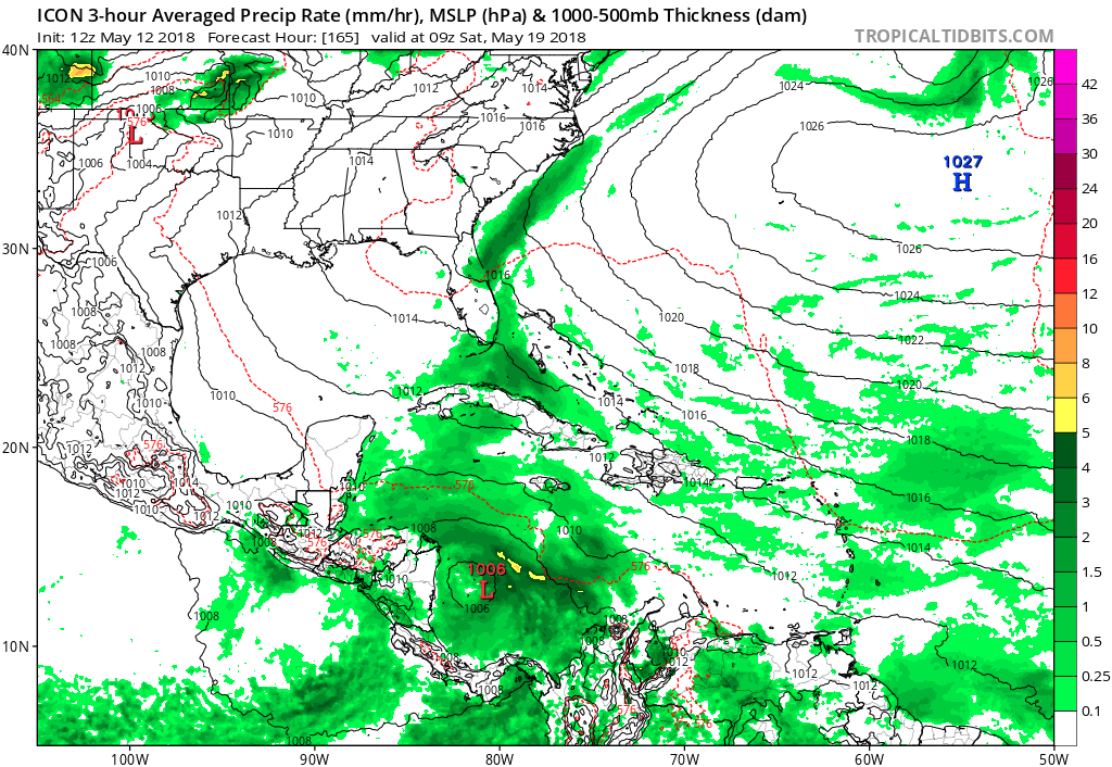
ICON with a 1006mb low in the SW Caribbean 1 week from now:
0 likes
-
cycloneye
- Admin
- Posts: 149334
- Age: 69
- Joined: Thu Oct 10, 2002 10:54 am
- Location: San Juan, Puerto Rico
Re: 2018 Tropics: Global Model Runs Discussion (Out to day 16)
12z GFS is running again.
0 likes
Visit the Caribbean-Central America Weather Thread where you can find at first post web cams,radars
and observations from Caribbean basin members Click Here
and observations from Caribbean basin members Click Here
-
gatorcane
- S2K Supporter
- Posts: 23708
- Age: 48
- Joined: Sun Mar 13, 2005 3:54 pm
- Location: Boca Raton, FL
Re: 2018 Tropics: Global Model Runs Discussion (Out to day 16)
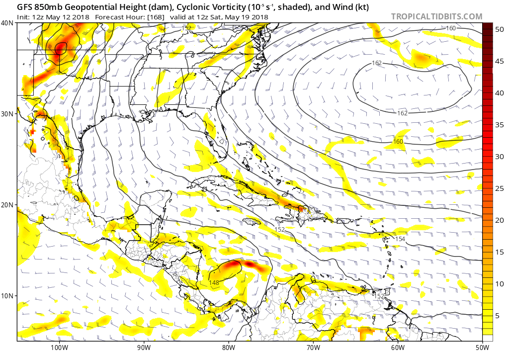
Delayed 12Z GFS coming in now is also forming a low like the ICON model in the SW Caribbean. At 168 hours below. Just maybe timeframe is coming in???
1 likes
-
gatorcane
- S2K Supporter
- Posts: 23708
- Age: 48
- Joined: Sun Mar 13, 2005 3:54 pm
- Location: Boca Raton, FL
Re: 2018 Tropics: Global Model Runs Discussion (Out to day 16)
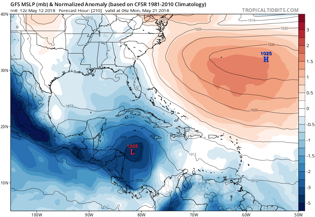
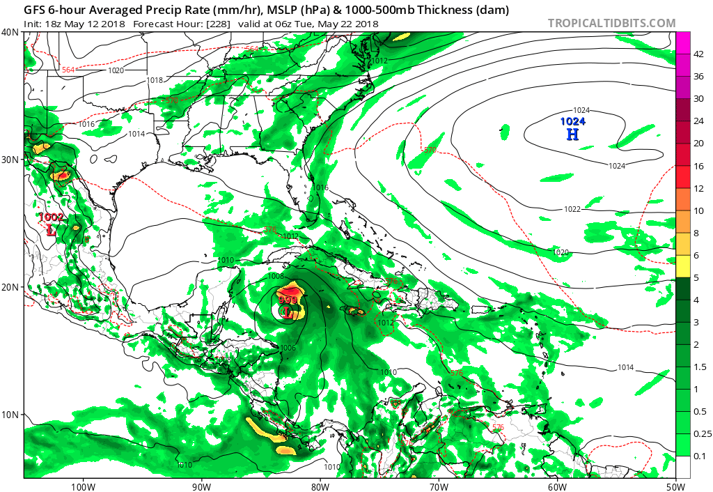
210 hours heading towards NW Caribbean and gaining strength:
1 likes
-
gatorcane
- S2K Supporter
- Posts: 23708
- Age: 48
- Joined: Sun Mar 13, 2005 3:54 pm
- Location: Boca Raton, FL
Re: 2018 Tropics: Global Model Runs Discussion (Out to day 16)
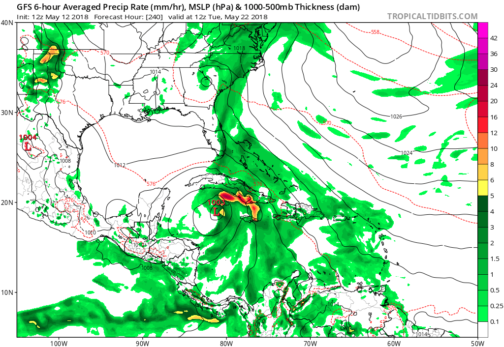
Heading NNE at 240 hours. This GFS run is more believable out through 10 days as it shows a sheared tropical storm. Notice timeframe has accelerated from previous runs. Track is closer to climo too. Very interesting run makes me believe the GFS a bit more now.
1 likes
-
cycloneye
- Admin
- Posts: 149334
- Age: 69
- Joined: Thu Oct 10, 2002 10:54 am
- Location: San Juan, Puerto Rico
Re: 2018 Tropics: Global Model Runs Discussion (Out to day 16)
Surprised there is no post about what looks like ECMWF lowering pressures east of Belize.Maybe GFS may not be alone?

0 likes
Visit the Caribbean-Central America Weather Thread where you can find at first post web cams,radars
and observations from Caribbean basin members Click Here
and observations from Caribbean basin members Click Here
-
cycloneye
- Admin
- Posts: 149334
- Age: 69
- Joined: Thu Oct 10, 2002 10:54 am
- Location: San Juan, Puerto Rico
Re: 2018 Tropics: Global Model Runs Discussion (Out to day 16)
@pppapin
Putting aside the #GFS fantasy canes beyond forecast day 10, the low-level westerlies forecast to develop next week over the EPAC is a favorable pattern for a large-scale circulation (i.e., a #CentralAmericanGyre) to develop.
This idea is supported by both the ECMWF & GFS.
https://twitter.com/pppapin/status/995426333852237824
1 likes
Visit the Caribbean-Central America Weather Thread where you can find at first post web cams,radars
and observations from Caribbean basin members Click Here
and observations from Caribbean basin members Click Here
-
gatorcane
- S2K Supporter
- Posts: 23708
- Age: 48
- Joined: Sun Mar 13, 2005 3:54 pm
- Location: Boca Raton, FL
Re: 2018 Tropics: Global Model Runs Discussion (Out to day 16)
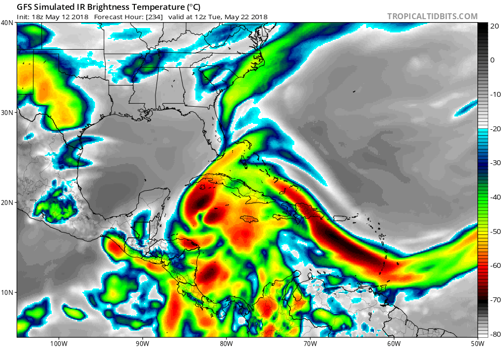
18Z GFS looks like it is back to the idea of a hurricane and timeframe is no longer moving out folks. Seems the GFS idea of some kind of monsoon trough that may spark genesis could be right after all especially looking at the latest ECMWF. Simulated IR impressive for May!
1 likes
Who is online
Users browsing this forum: tolakram and 41 guests