2020 Global Model Runs Discussion (Out thru day 16)
Moderator: S2k Moderators
Forum rules

The posts in this forum are NOT official forecasts and should not be used as such. They are just the opinion of the poster and may or may not be backed by sound meteorological data. They are NOT endorsed by any professional institution or STORM2K. For official information, please refer to products from the National Hurricane Center and National Weather Service.

Re: 2020 Global Model Runs Discussion (Out thru day 16)
lm**o at the GFS 00z. Haha. We're close to 2 weeks of being in MJO Phase 2 per CPC, but maybe it's a little sooner if you want to go with the JMA. Still, this is June. You don't need a potentially Rita-sized system cut off and spinning down there. It would mess lots of things up. IDK, it's just too early but amusing for sure.
3 likes
-
Kingarabian

- S2K Supporter

- Posts: 16360
- Joined: Sat Aug 08, 2009 3:06 am
- Location: Honolulu, Hawaii
Re: 2020 Global Model Runs Discussion (Out thru day 16)
The 00z GFS is wtf lol
Finishes off like this:

Finishes off like this:
0 likes
RIP Kobe Bryant

Re: 2020 Global Model Runs Discussion (Out thru day 16)
NHC has the EPAC on watch


ZCZC MIATWOEP ALL
TTAA00 KNHC DDHHMM
Tropical Weather Outlook
NWS National Hurricane Center Miami FL
1100 PM PDT Tue May 26 2020
For the eastern North Pacific...east of 140 degrees west longitude:
1. A large area of disorganized showers and thunderstorms located a
few hundred miles south of the coasts of southern Mexico,
Guatemala, and El Salvador are associated with a trough of low
pressure. Environmental conditions appear conducive for gradual
development of this system, and a tropical depression is likely to
form late this week or over the weekend while it drifts northward.
* Formation chance through 48 hours...low...10 percent.
* Formation chance through 5 days...high...70 percent.
Forecaster Cangialosi
0 likes
Re: 2020 Global Model Runs Discussion (Out thru day 16)
More consistency in the models this morning with the crossover somewhere between Oaxcaca and western Yucatan.
Relatively flat landscape, with better chance for the LL vort to stay intact.
If this makes it into the BOC / GOM, possibly sometimes early to mid net week, looks like it may meander for sometime.
Relatively flat landscape, with better chance for the LL vort to stay intact.
If this makes it into the BOC / GOM, possibly sometimes early to mid net week, looks like it may meander for sometime.
1 likes
Re: 2020 Global Model Runs Discussion (Out thru day 16)
Ensembles appear to have an approximate 50/50 split this goes into the BOC or moves west into the EPAC as the LL vort attempts to cross the Isthmus of Tehuantepec.
0 likes
-
MississippiWx

- S2K Supporter
- Posts: 1720
- Joined: Sat Aug 14, 2010 1:44 pm
- Location: Hattiesburg, Mississippi
Re: 2020 Global Model Runs Discussion (Out thru day 16)
I know the main focus in this thread is the CAG development, but I wouldn’t bypass the feature in the South-Central Atlantic. It has shown persistent convection and models show it forming a surface low over the next couple of days. This could be one of those subtropical/hybrid developments we’ve grown to know and love in the Atlantic the past decade.
Just something else to watch as we transition from Bertha to the CAG feature.
Just something else to watch as we transition from Bertha to the CAG feature.
3 likes
This post is not an official forecast and should not be used as such. It is just the opinion of MississippiWx and may or may not be backed by sound meteorological data. It is not endorsed by any professional institution including storm2k.org. For Official Information please refer to the NHC and NWS products.


Re: 2020 Global Model Runs Discussion (Out thru day 16)
MississippiWx wrote:I know the main focus in this thread is the CAG development, but I wouldn’t bypass the feature in the South-Central Atlantic. It has shown persistent convection and models show it forming a surface low over the next couple of days. This could be one of those subtropical/hybrid developments we’ve grown to know and love in the Atlantic the past decade.
Just something else to watch as we transition from Bertha to the CAG feature.
Yep, timing of this system gives us a decent shot at a record-breaking 3rd named storm before June 1st (peak organization looks to be on May 31st).
0 likes

Re: 2020 Global Model Runs Discussion (Out thru day 16)
The GFS also has a small system forming on the SW Caribbean, separate from the CAG/crossover feature (until it gets absorbed), around 132-144 hours out. This little guy has been appearing in a couple of runs, and since it’s only 6-7 days out, it might be time to take it a little more seriously.
0 likes
Irene '11 Sandy '12 Hermine '16 5/15/2018 Derecho Fay '20 Isaias '20 Elsa '21 Henri '21 Ida '21
I am only a meteorology enthusiast who knows a decent amount about tropical cyclones. Look to the professional mets, the NHC, or your local weather office for the best information.
I am only a meteorology enthusiast who knows a decent amount about tropical cyclones. Look to the professional mets, the NHC, or your local weather office for the best information.
-
SFLcane

- S2K Supporter
- Posts: 10281
- Age: 48
- Joined: Sat Jun 05, 2010 1:44 pm
- Location: Lake Worth Florida
Re: 2020 Global Model Runs Discussion (Out thru day 16)
GFS has come around to the Euro... Gyre gets caught on Central America.
0 likes
-
AutoPenalti
- Category 5

- Posts: 4091
- Age: 29
- Joined: Mon Aug 17, 2015 4:16 pm
- Location: Ft. Lauderdale, Florida
Re: 2020 Global Model Runs Discussion (Out thru day 16)
SFLcane wrote:GFS has come around to the Euro... Gyre gets caught on Central America.
Really? One run and it’s come back around to the Euro?
0 likes
The posts in this forum are NOT official forecasts and should not be used as such. They are just the opinion of the poster and may or may not be backed by sound meteorological data. They are NOT endorsed by any professional institution or STORM2K. For official information, please refer to products from the NHC and NWS.
Model Runs Cheat Sheet:
GFS (5:30 AM/PM, 11:30 AM/PM)
HWRF, GFDL, UKMET, NAVGEM (6:30-8:00 AM/PM, 12:30-2:00 AM/PM)
ECMWF (1:45 AM/PM)
TCVN is a weighted averaged
-
SFLcane
- S2K Supporter
- Posts: 10281
- Age: 48
- Joined: Sat Jun 05, 2010 1:44 pm
- Location: Lake Worth Florida
Re: 2020 Global Model Runs Discussion (Out thru day 16)
AutoPenalti wrote:SFLcane wrote:GFS has come around to the Euro... Gyre gets caught on Central America.
Really? One run and it’s come back around to the Euro?
Pulls a a strengthening storm NE towards FL. BUT That's beyond the range of even considering it lol.
0 likes
Re: 2020 Global Model Runs Discussion (Out thru day 16)
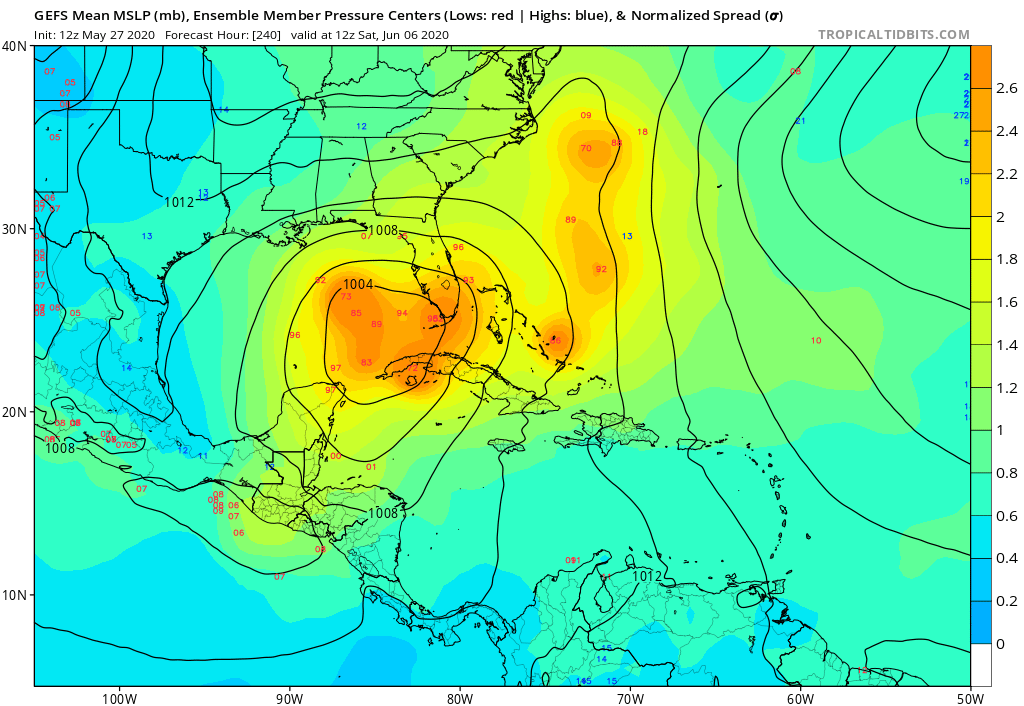
Long range 12z GFS goes nuts and wants a Cat 2 hurricane in the Gulf by mid-June.
It is only late May, and we’ve had two TCs, and the GFS is already going berserk. Wonder what the next few months will bring...
It is only late May, and we’ve had two TCs, and the GFS is already going berserk. Wonder what the next few months will bring...
1 likes
Irene '11 Sandy '12 Hermine '16 5/15/2018 Derecho Fay '20 Isaias '20 Elsa '21 Henri '21 Ida '21
I am only a meteorology enthusiast who knows a decent amount about tropical cyclones. Look to the professional mets, the NHC, or your local weather office for the best information.
I am only a meteorology enthusiast who knows a decent amount about tropical cyclones. Look to the professional mets, the NHC, or your local weather office for the best information.
-
jasons2k

- Storm2k Executive

- Posts: 8290
- Age: 52
- Joined: Wed Jul 06, 2005 12:32 pm
- Location: The Woodlands, TX
Re: 2020 Global Model Runs Discussion (Out thru day 16)
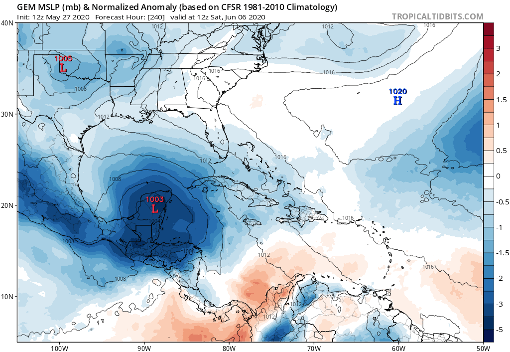
Worth reading from the NWS-HGX's overnight AFD:
Beyond 240 hours? Why are you asking beyond 240 hours? If beyond
240 hours you go, only pain will you find. Yes, I see what the
GFS is doing way out there, and I bring it up for the SOLE.
PURPOSE. of being a buzzkill. We are now approaching the time of
year when the GFS loves to generate tropical cyclones in the
western Gulf out of the Central American Gyre in its extended
range. The GFS does this...a lot. Every once in a great while, it
happens in real life, too! So, if someone starts buzzing about
the hurricane in the Gulf in two weeks, let us all take a deep
breath and remember that far more likely than not, this is just
the GFS reminding us that it is almost June, and nothing more.
Regardless of what one model says about a couple weeks out, it is
almost hurricane season, and we should be working on being
prepared for anything that may come in the next several months as
a matter of course.
7 likes
-
AutoPenalti
- Category 5
- Posts: 4091
- Age: 29
- Joined: Mon Aug 17, 2015 4:16 pm
- Location: Ft. Lauderdale, Florida
Re: 2020 Global Model Runs Discussion (Out thru day 16)
SFLcane wrote:AutoPenalti wrote:SFLcane wrote:GFS has come around to the Euro... Gyre gets caught on Central America.
Really? One run and it’s come back around to the Euro?
Pulls a a strengthening storm NE towards FL. BUT That's beyond the range of even considering it lol.
Gotta love the GFS
0 likes
The posts in this forum are NOT official forecasts and should not be used as such. They are just the opinion of the poster and may or may not be backed by sound meteorological data. They are NOT endorsed by any professional institution or STORM2K. For official information, please refer to products from the NHC and NWS.
Model Runs Cheat Sheet:
GFS (5:30 AM/PM, 11:30 AM/PM)
HWRF, GFDL, UKMET, NAVGEM (6:30-8:00 AM/PM, 12:30-2:00 AM/PM)
ECMWF (1:45 AM/PM)
TCVN is a weighted averaged
-
toad strangler

- S2K Supporter
- Posts: 4546
- Joined: Sun Jul 28, 2013 3:09 pm
- Location: Earth
- Contact:
Re: 2020 Global Model Runs Discussion (Out thru day 16)
AutoPenalti wrote:SFLcane wrote:AutoPenalti wrote:Really? One run and it’s come back around to the Euro?
Pulls a a strengthening storm NE towards FL. BUT That's beyond the range of even considering it lol.
Gotta love the GFS
When I saw yesterday the entire gyre break off like a runaway Ferris wheel into the Texas coast I knew it was up to it's old tricks
1 likes
My Weather Station
https://www.wunderground.com/dashboard/pws/KFLPORTS603
https://www.wunderground.com/dashboard/pws/KFLPORTS603

-
AutoPenalti
- Category 5
- Posts: 4091
- Age: 29
- Joined: Mon Aug 17, 2015 4:16 pm
- Location: Ft. Lauderdale, Florida
Re: 2020 Global Model Runs Discussion (Out thru day 16)
gatorcane wrote:The GFS ensembles day 10:
https://i.postimg.cc/DZxGchWj/gfs-ememb-lowlocs-watl-41.png
Some stronger members this run, still extremely early.
0 likes
The posts in this forum are NOT official forecasts and should not be used as such. They are just the opinion of the poster and may or may not be backed by sound meteorological data. They are NOT endorsed by any professional institution or STORM2K. For official information, please refer to products from the NHC and NWS.
Model Runs Cheat Sheet:
GFS (5:30 AM/PM, 11:30 AM/PM)
HWRF, GFDL, UKMET, NAVGEM (6:30-8:00 AM/PM, 12:30-2:00 AM/PM)
ECMWF (1:45 AM/PM)
TCVN is a weighted averaged
-
Shell Mound
- Category 5
- Posts: 2432
- Age: 33
- Joined: Thu Sep 07, 2017 3:39 pm
- Location: St. Petersburg, FL → Scandinavia
Re: 2020 Global Model Runs Discussion (Out thru day 16)
The 00Z ECMWF now officially shows long-range development over/near the Yucatán Peninsula and southern Gulf of Mexico, in relation to the cross-over gyration.
0 likes
CVW / MiamiensisWx / Shell Mound
The posts in this forum are NOT official forecasts and should not be used as such. They are just the opinion of the poster and may or may not be backed by sound meteorological data. They are NOT endorsed by any professional institution or STORM2K. For official information, please refer to products from the NHC and NWS.

Re: 2020 Global Model Runs Discussion (Out thru day 16)

0z Euro; +120hr
Sent from my iPhone using Tapatalk
1 likes
Who is online
Users browsing this forum: No registered users and 340 guests