
Mike(spaghetti models) seems to be confident in the GFS's troughs which would keep the next wave of tropical waves from making it to the CONUS.
We will see. While I think there will be enough troughiness to erode the ridge, I do think it will be a small window and the ridge will build back. I would not say the US is safe from Cape Verde systems this soon.
2020 Global Model Runs Discussion (Out thru day 16)
Moderator: S2k Moderators
Forum rules

The posts in this forum are NOT official forecasts and should not be used as such. They are just the opinion of the poster and may or may not be backed by sound meteorological data. They are NOT endorsed by any professional institution or STORM2K. For official information, please refer to products from the National Hurricane Center and National Weather Service.
-
stormlover2013
Re: 2020 Global Model Runs Discussion (Out thru day 16)
Jr0d wrote:Mike(spaghetti models) seems to be confident in the GFS's troughs which would keep the next wave of tropical waves from making it to the CONUS.
We will see. While I think there will be enough troughiness to erode the ridge, I do think it will be a small window and the ridge will build back. I would not say the US is safe from Cape Verde systems this soon.
spag models are the worse enemy lol
0 likes

Re: 2020 Global Model Runs Discussion (Out thru day 16)
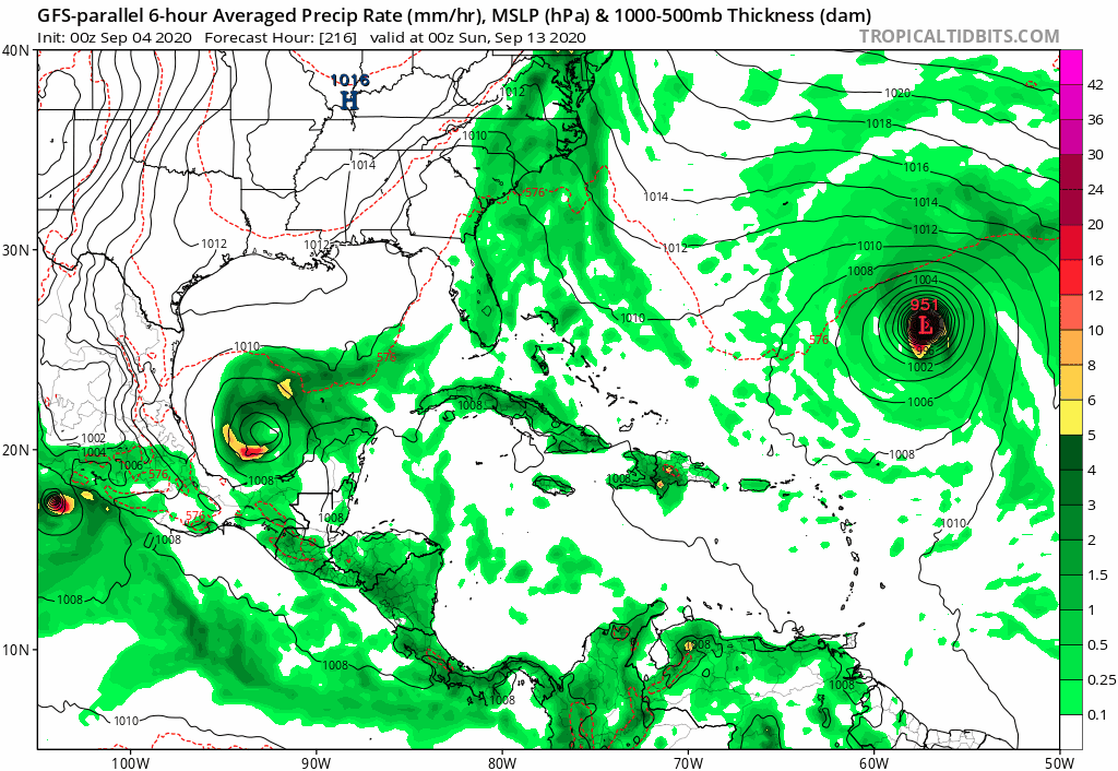
0z GFS-Para continues with its very aggressive runs, I guess we are having our old aggressive GFS back after the upgrade 

Its ensembles are also very aggressive.

Its ensembles are also very aggressive.
1 likes
Re: 2020 Global Model Runs Discussion (Out thru day 16)
NDG wrote:0z GFS-Para continues with its very aggressive runs, I guess we are having our old aggressive GFS back after the upgrade
https://i.imgur.com/e8a9ivt.png
Its ensembles are also very aggressive.
https://i.imgur.com/phiCuCY.png
So if I'm reading this right there will be a home grown major hurricane in the GoM, a Major Hurricane off the East Coast that forms from ???, and another Major Hurricane in the Atlantic from one of those 4 waves that are color coded this morning.
0 likes
Personal Forecast Disclaimer:
The posts in this forum are NOT official forecast and should not be used as such. They are just the opinion of the poster and may or may not be backed by sound meteorological data. They are NOT endorsed by any professional institution or storm2k.org. For official information, please refer to the NHC and NWS products.
The posts in this forum are NOT official forecast and should not be used as such. They are just the opinion of the poster and may or may not be backed by sound meteorological data. They are NOT endorsed by any professional institution or storm2k.org. For official information, please refer to the NHC and NWS products.

Re: 2020 Global Model Runs Discussion (Out thru day 16)
Blinhart wrote:NDG wrote:0z GFS-Para continues with its very aggressive runs, I guess we are having our old aggressive GFS back after the upgrade
https://i.imgur.com/e8a9ivt.png
Its ensembles are also very aggressive.
https://i.imgur.com/phiCuCY.png
So if I'm reading this right there will be a home grown major hurricane in the GoM, a Major Hurricane off the East Coast that forms from ???, and another Major Hurricane in the Atlantic from one of those 4 waves that are color coded this morning.
Yea that's 2020!
0 likes
-
TheStormExpert
Re: 2020 Global Model Runs Discussion (Out thru day 16)
NDG wrote:0z GFS-Para continues with its very aggressive runs, I guess we are having our old aggressive GFS back after the upgrade
https://i.imgur.com/e8a9ivt.png
Its ensembles are also very aggressive.
https://i.imgur.com/phiCuCY.png
Not sure if I believe this run of the GFS-Parallel.
0 likes
-
AutoPenalti
- Category 5

- Posts: 4091
- Age: 29
- Joined: Mon Aug 17, 2015 4:16 pm
- Location: Ft. Lauderdale, Florida
Re: 2020 Global Model Runs Discussion (Out thru day 16)
TheStormExpert wrote:NDG wrote:0z GFS-Para continues with its very aggressive runs, I guess we are having our old aggressive GFS back after the upgrade
https://i.imgur.com/e8a9ivt.png
Its ensembles are also very aggressive.
https://i.imgur.com/phiCuCY.png
Not sure if I believe this run of the GFS-Parallel.
Of course not! The amount of headassery in resolving fujiwhara-esque runs resulting in some odd majors at the same time AND not to mention the trough teleconnection from the WPAC typhoons is insane.
1 likes
The posts in this forum are NOT official forecasts and should not be used as such. They are just the opinion of the poster and may or may not be backed by sound meteorological data. They are NOT endorsed by any professional institution or STORM2K. For official information, please refer to products from the NHC and NWS.
Model Runs Cheat Sheet:
GFS (5:30 AM/PM, 11:30 AM/PM)
HWRF, GFDL, UKMET, NAVGEM (6:30-8:00 AM/PM, 12:30-2:00 AM/PM)
ECMWF (1:45 AM/PM)
TCVN is a weighted averaged
-
Hurricaneman

- Category 5
- Posts: 7404
- Age: 45
- Joined: Tue Aug 31, 2004 3:24 pm
- Location: central florida
Re: 2020 Global Model Runs Discussion (Out thru day 16)
I think the Euro might have better interpretation of what’s going on than the GFS, the GFS seems to be fujiwaraing everything while the Euro moves things right along
0 likes
-
SFLcane

- S2K Supporter

- Posts: 10281
- Age: 48
- Joined: Sat Jun 05, 2010 1:44 pm
- Location: Lake Worth Florida
Re: 2020 Global Model Runs Discussion (Out thru day 16)
GFS para long range taking second wave highlighted by nhc towards FL. Fantasy land
0 likes
Re: 2020 Global Model Runs Discussion (Out thru day 16)
Compared to just 48 hours ago, the good news is that the consensus of the various ensembles is so much less threatening to the CONUS and Bahamas from MDR systems due to recurves way OTS. Even today’s 0Z EPS is less threatening than that run from yesterday regarding the wave expected to emerge from Africa ~Sept 9.
That still doesn’t mean no threat yet. Also, we can’t see beyond this period as MDR storms can still threaten later in the month, especially in La Niña. But I still say the bigger threat for the next 7-10 days or so will probably be from something forming much closer, including possible homegrown. Hopefully not but something to keep an eye on.
That still doesn’t mean no threat yet. Also, we can’t see beyond this period as MDR storms can still threaten later in the month, especially in La Niña. But I still say the bigger threat for the next 7-10 days or so will probably be from something forming much closer, including possible homegrown. Hopefully not but something to keep an eye on.
Last edited by LarryWx on Fri Sep 04, 2020 12:42 pm, edited 2 times in total.
0 likes
Personal Forecast Disclaimer:
The posts in this forum are NOT official forecasts and should not be used as such. They are just the opinion of the poster and may or may not be backed by sound meteorological data. They are NOT endorsed by any professional institution or storm2k.org. For official information, please refer to the NHC and NWS products.
The posts in this forum are NOT official forecasts and should not be used as such. They are just the opinion of the poster and may or may not be backed by sound meteorological data. They are NOT endorsed by any professional institution or storm2k.org. For official information, please refer to the NHC and NWS products.
-
SFLcane
- S2K Supporter
- Posts: 10281
- Age: 48
- Joined: Sat Jun 05, 2010 1:44 pm
- Location: Lake Worth Florida
Re: 2020 Global Model Runs Discussion (Out thru day 16)
LarryWx wrote:Compared to just 48 hours ago, the good news is that the consensus of the various ensembles is so much less threatening to the CONUS and Bahamas from MDR systems due to recurves way OTS. Even today’s 0Z EPS is less threatening than that run from yesterday regarding the wave expected to emerge from Africa ~Sept 9.
That still doesn’t mean no threat yet. But I still say the bigger threat for the next 7-10 days or so will probably be from something forming much closer, including possible homegrown. Hopefully not but something to keep an eye on.
Larry thoughts on the second wave highlighted by the nhc para driving it further westward last couple runs. Long range
0 likes
-
Spacecoast

- Category 2

- Posts: 773
- Joined: Thu Aug 31, 2017 2:03 pm

Re: 2020 Global Model Runs Discussion (Out thru day 16)
SFLcane wrote:LarryWx wrote:Compared to just 48 hours ago, the good news is that the consensus of the various ensembles is so much less threatening to the CONUS and Bahamas from MDR systems due to recurves way OTS. Even today’s 0Z EPS is less threatening than that run from yesterday regarding the wave expected to emerge from Africa ~Sept 9.
That still doesn’t mean no threat yet. But I still say the bigger threat for the next 7-10 days or so will probably be from something forming much closer, including possible homegrown. Hopefully not but something to keep an eye on.
Larry thoughts on the second wave highlighted by the nhc para driving it further westward last couple runs. Long range
They are outliers, even when compared to their own ensembles (para). Furthermore, they’re in cartoonland. So, I wouldn’t worry much about it until if and when the various ensembles do more with it (sort of like what that EPS run of yesterday that had ~12-13 threatening members out of 51 as even today’s 0Z has backed down quite a bit from that).
0 likes
Personal Forecast Disclaimer:
The posts in this forum are NOT official forecasts and should not be used as such. They are just the opinion of the poster and may or may not be backed by sound meteorological data. They are NOT endorsed by any professional institution or storm2k.org. For official information, please refer to the NHC and NWS products.
The posts in this forum are NOT official forecasts and should not be used as such. They are just the opinion of the poster and may or may not be backed by sound meteorological data. They are NOT endorsed by any professional institution or storm2k.org. For official information, please refer to the NHC and NWS products.
-
USTropics
- Professional-Met

- Posts: 2738
- Joined: Sun Aug 12, 2007 3:45 am
- Location: Florida State University
Re: 2020 Global Model Runs Discussion (Out thru day 16)
NDG wrote:0z GFS-Para continues with its very aggressive runs, I guess we are having our old aggressive GFS back after the upgrade
https://i.imgur.com/e8a9ivt.png
Its ensembles are also very aggressive.
https://i.imgur.com/phiCuCY.png
This fits with the past 4 EMCWF ensemble runs:

As always we're looking at an almost 2 week forecast, but some semblance of agreement between the GFS/ECMWF camps that the wave coming off Africa soon has decent chances of genesis in this vicinity. We'll see if consistency remains. The models have started to resolve the longwave pattern over NA in the 5-7 day range with some agreement between camps (a cutoff low diving SW is becoming increasingly likely), but what comes of the monsoon gyre in the east Atlantic remains a mystery.
One other thing to note, the evolution of the trough over the central Atlantic is super important. Ignoring where the GFS is showing genesis currently, just focus on how the past 6 runs have trended with a weaker and slightly further NE location with each run of the trough.

3 likes

Re: 2020 Global Model Runs Discussion (Out thru day 16)
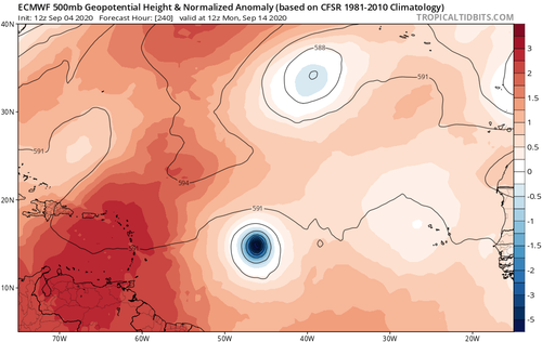
I do not like the look of the 12z 500mb pattern and trends. Spliting the US yrough and looks to lokk in a blocking ridge. Still a path out but anything that makes it past 60W is a problem.
1 likes
Re: 2020 Global Model Runs Discussion (Out thru day 16)
drezee wrote:I do not like the look of the 12z 500mb pattern and trends. Spliting the US yrough and looks to lokk in a blocking ridge. Still a path out but anything that makes it past 60W is a problem.
Yes, if any CV system got past 60W it could be a problem based on this pattern. However, the ensembles are clearly saying that this same pattern is fortunately also making it very difficult for any CV system to get far enough west to be a problem with very early recurving strongly favored. The higher risk for the first half of Sept is from something originating already underneath the WAR (much closer to the CONUS). Hopefully nothing from there and the US could rest easy for a change, but we’ll have to see.
0 likes
Personal Forecast Disclaimer:
The posts in this forum are NOT official forecasts and should not be used as such. They are just the opinion of the poster and may or may not be backed by sound meteorological data. They are NOT endorsed by any professional institution or storm2k.org. For official information, please refer to the NHC and NWS products.
The posts in this forum are NOT official forecasts and should not be used as such. They are just the opinion of the poster and may or may not be backed by sound meteorological data. They are NOT endorsed by any professional institution or storm2k.org. For official information, please refer to the NHC and NWS products.
-
WeatherEmperor
- S2K Supporter
- Posts: 4806
- Age: 42
- Joined: Thu Sep 04, 2003 2:54 pm
- Location: South Florida
Re: 2020 Global Model Runs Discussion (Out thru day 16)
Look at this monster the Euro has moving WNW towards the islands. It has been showing this a few runs now. Lets hope future Euro runs has this missing the islands to the north

Sent from my iPhone using Tapatalk
Sent from my iPhone using Tapatalk
0 likes
-
toad strangler

- S2K Supporter
- Posts: 4546
- Joined: Sun Jul 28, 2013 3:09 pm
- Location: Earth
- Contact:
Re: 2020 Global Model Runs Discussion (Out thru day 16)
12z Euro shows a potential problem for islands / CONUS at 10 days
0 likes
My Weather Station
https://www.wunderground.com/dashboard/pws/KFLPORTS603
https://www.wunderground.com/dashboard/pws/KFLPORTS603
-
cycloneye

- Admin

- Posts: 149505
- Age: 69
- Joined: Thu Oct 10, 2002 10:54 am
- Location: San Juan, Puerto Rico
Re: 2020 Global Model Runs Discussion (Out thru day 16)
A powerhouse but will it miss the islands?

0 likes
Visit the Caribbean-Central America Weather Thread where you can find at first post web cams,radars
and observations from Caribbean basin members Click Here
and observations from Caribbean basin members Click Here
-
TheStormExpert
Re: 2020 Global Model Runs Discussion (Out thru day 16)
Likely not with that ridge overhead, but it’s 10 days out.
Last edited by TheStormExpert on Fri Sep 04, 2020 2:52 pm, edited 2 times in total.
0 likes
Who is online
Users browsing this forum: hurricanes1234 and 308 guests