ENSO Updates (2007 thru 2023)

This is the general tropical discussion area. Anyone can take their shot at predicting a storms path.

Moderator: S2k Moderators

Forum rules

The posts in this forum are NOT official forecasts and should not be used as such. They are just the opinion of the poster and may or may not be backed by sound meteorological data. They are NOT endorsed by any professional institution or STORM2K. For official information, please refer to products from the National Hurricane Center and National Weather Service.

Help Support Storm2K
Message
Author
User avatar
NDG
S2K Supporter
S2K Supporter
Posts: 15446
Joined: Sun Jul 09, 2006 10:14 pm
Location: Orlando, FL

#2001 Postby NDG » Thu Apr 26, 2012 7:29 am

A lot forecasts are going to bust if El Nino does come to fruition as forecasted by the ECMWF.

In the past two weeks Nino 3 Region has cooled down nicely.

Image

Image
0 likes   

User avatar
Kingarabian
S2K Supporter
S2K Supporter
Posts: 15980
Joined: Sat Aug 08, 2009 3:06 am
Location: Honolulu, Hawaii

#2002 Postby Kingarabian » Thu Apr 26, 2012 6:50 pm

Is there a way to check when the MJO returns to the pacific?
0 likes   
RIP Kobe Bryant

User avatar
cycloneye
Admin
Admin
Posts: 145299
Age: 68
Joined: Thu Oct 10, 2002 10:54 am
Location: San Juan, Puerto Rico

Re: ENSO Updates

#2003 Postby cycloneye » Thu Apr 26, 2012 9:25 pm

Here is a good loop of the Pacific from January 5th to April 26th that shows how it warms and cools in periods.Notice at the last frames how the cooling returns.

Image
0 likes   
Visit the Caribbean-Central America Weather Thread where you can find at first post web cams,radars
and observations from Caribbean basin members Click Here

User avatar
Ntxw
Storm2k Moderator
Storm2k Moderator
Posts: 22784
Joined: Wed Oct 21, 2009 6:34 pm
Location: DFW, Texas

Re:

#2004 Postby Ntxw » Fri Apr 27, 2012 10:51 am

Kingarabian wrote:Is there a way to check when the MJO returns to the pacific?


MJO information can be found on the CPC site along with ENSO and various other products. Just find it on the left panel.

http://www.cpc.ncep.noaa.gov/

The MJO is currently over the Maritime continent region (Indonesia) and sprouting convection in the western pacific in a weakened state. As a response, on cue the daily SOI has tanked the past two days. Fluctuations will continue through May, my guess is another tank mid month as possibly a stronger wave might commence.
0 likes   
The above post and any post by Ntxw is NOT an official forecast and should not be used as such. It is just the opinion of the poster and may or may not be backed by sound meteorological data. It is NOT endorsed by any professional institution including Storm2k. For official information, please refer to NWS products.

  Help support Storm2K!
Help Support Storm2K

joshb19882004
Tropical Low
Tropical Low
Posts: 23
Joined: Thu Apr 05, 2012 10:10 am

#2005 Postby joshb19882004 » Fri Apr 27, 2012 12:30 pm

daily soi has sharply droped negative http://www.longpaddock.qld.gov.au/seaso ... soivalues/
0 likes   

User avatar
Kingarabian
S2K Supporter
S2K Supporter
Posts: 15980
Joined: Sat Aug 08, 2009 3:06 am
Location: Honolulu, Hawaii

Re: Re:

#2006 Postby Kingarabian » Fri Apr 27, 2012 9:12 pm

Ntxw wrote:
Kingarabian wrote:Is there a way to check when the MJO returns to the pacific?


MJO information can be found on the CPC site along with ENSO and various other products. Just find it on the left panel.

http://www.cpc.ncep.noaa.gov/

The MJO is currently over the Maritime continent region (Indonesia) and sprouting convection in the western pacific in a weakened state. As a response, on cue the daily SOI has tanked the past two days. Fluctuations will continue through May, my guess is another tank mid month as possibly a stronger wave might commence.

Thanks <3.
0 likes   
RIP Kobe Bryant

User avatar
cycloneye
Admin
Admin
Posts: 145299
Age: 68
Joined: Thu Oct 10, 2002 10:54 am
Location: San Juan, Puerto Rico

Re: ENSO Updates

#2007 Postby cycloneye » Mon Apr 30, 2012 12:08 pm

Climate Prediction Center 4/30/12 update

Nino 3.4 is more warmer in this update -0.1C and that is up from -0.4C that was last week.

http://www.cpc.ncep.noaa.gov/products/a ... ts-web.pdf

Image
0 likes   
Visit the Caribbean-Central America Weather Thread where you can find at first post web cams,radars
and observations from Caribbean basin members Click Here

User avatar
SoupBone
Category 5
Category 5
Posts: 3111
Joined: Tue Sep 20, 2005 5:24 pm

Re:

#2008 Postby SoupBone » Tue May 01, 2012 8:00 am

NDG wrote:A lot forecasts are going to bust if El Nino does come to fruition as forecasted by the ECMWF.

In the past two weeks Nino 3 Region has cooled down nicely.


Can you explain this a little? I'm pretty unfamiliar with this area of Meteorology.
0 likes   

User avatar
cycloneye
Admin
Admin
Posts: 145299
Age: 68
Joined: Thu Oct 10, 2002 10:54 am
Location: San Juan, Puerto Rico

Re: ENSO=CPC 4/30/12 update=Nino 3.4 up to -0.1C

#2009 Postby cycloneye » Tue May 01, 2012 11:52 am

What a swing to the up side,as is the first time I see that CFSv2 goes to Moderate El Nino.

Image

http://origin.cpc.ncep.noaa.gov/product ... cfsv2fcst/
0 likes   
Visit the Caribbean-Central America Weather Thread where you can find at first post web cams,radars
and observations from Caribbean basin members Click Here

User avatar
Ntxw
Storm2k Moderator
Storm2k Moderator
Posts: 22784
Joined: Wed Oct 21, 2009 6:34 pm
Location: DFW, Texas

#2010 Postby Ntxw » Tue May 01, 2012 12:34 pm

90 day SOI is running consistently negative, not quite enough for El Nino while the 30 day average has been consistent with warm neutral. 2002 and 2009 have been consistent analogs regarding evolution of ENSO so far this year.
0 likes   
The above post and any post by Ntxw is NOT an official forecast and should not be used as such. It is just the opinion of the poster and may or may not be backed by sound meteorological data. It is NOT endorsed by any professional institution including Storm2k. For official information, please refer to NWS products.


  Help support Storm2K!

Help Support Storm2K


User avatar
Kingarabian
S2K Supporter
S2K Supporter
Posts: 15980
Joined: Sat Aug 08, 2009 3:06 am
Location: Honolulu, Hawaii

#2011 Postby Kingarabian » Wed May 02, 2012 1:48 am

When does the Euro update?
0 likes   
RIP Kobe Bryant

User avatar
cycloneye
Admin
Admin
Posts: 145299
Age: 68
Joined: Thu Oct 10, 2002 10:54 am
Location: San Juan, Puerto Rico

Re:

#2012 Postby cycloneye » Wed May 02, 2012 5:49 am

Kingarabian wrote:When does the Euro update?


The operational ENSO along with the latest MSLP updates on the 15th and the Eurosip ensembles on the 22nd.
0 likes   
Visit the Caribbean-Central America Weather Thread where you can find at first post web cams,radars
and observations from Caribbean basin members Click Here

User avatar
Ntxw
Storm2k Moderator
Storm2k Moderator
Posts: 22784
Joined: Wed Oct 21, 2009 6:34 pm
Location: DFW, Texas

#2013 Postby Ntxw » Wed May 02, 2012 11:33 am

Last bit of cool anomalies is hanging to dear life underneath the surface. Question is when will the warm pool upwell and signal the coming Nino?

http://www.cpc.ncep.noaa.gov...enso_update/wkxzteq.shtml
0 likes   
The above post and any post by Ntxw is NOT an official forecast and should not be used as such. It is just the opinion of the poster and may or may not be backed by sound meteorological data. It is NOT endorsed by any professional institution including Storm2k. For official information, please refer to NWS products.


  Help support Storm2K!

Help Support Storm2K


CrazyC83
Professional-Met
Professional-Met
Posts: 34002
Joined: Tue Mar 07, 2006 11:57 pm
Location: Deep South, for the first time!

#2014 Postby CrazyC83 » Wed May 02, 2012 9:20 pm

Could this be setting up like 1982-83 or 1997-98?
0 likes   

User avatar
Ptarmigan
Category 5
Category 5
Posts: 5313
Joined: Wed Aug 16, 2006 9:06 pm

Re:

#2015 Postby Ptarmigan » Wed May 02, 2012 9:40 pm

CrazyC83 wrote:Could this be setting up like 1982-83 or 1997-98?
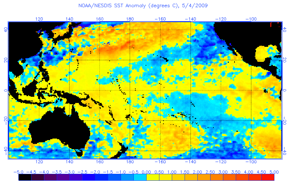

If I am correct, the Pacific was in a warmer phase in 1982-1983 and 1997-1998. Interesting you mentioned it, since some of the models are calling for strong El Nino.
0 likes   

User avatar
NDG
S2K Supporter
S2K Supporter
Posts: 15446
Joined: Sun Jul 09, 2006 10:14 pm
Location: Orlando, FL

#2016 Postby NDG » Thu May 03, 2012 7:25 am

I don't know if I want to use 2009 as an Analog year for 2012.
ENSO in 2009 had a much faster warm up during late April and into May, currently is not doing so, unless it changes during the month of May I am not including 2009 as an Analog year.

2002 fits better.

Current:
Image

Same time in 2009
Image
0 likes   

User avatar
Ntxw
Storm2k Moderator
Storm2k Moderator
Posts: 22784
Joined: Wed Oct 21, 2009 6:34 pm
Location: DFW, Texas

Re:

#2017 Postby Ntxw » Thu May 03, 2012 8:29 am

NDG wrote:I don't know if I want to use 2009 as an Analog year for 2012.
ENSO in 2009 had a much faster warm up during late April and into May, currently is not doing so, unless it changes during the month of May I am not including 2009 as an Analog year.

2002 fits better.
.

No two enso's are exactly alike or evolve the exact same way. 2009 is a good longterm analog because of nina-nina-nino. There are few of those so it's included in the pool. Wxman posted a graph somewhere how the enso 3.4 rise and falls for the past year has resembled similarly to the 08-09 frame. However, 09 was forecasting a moderate nino and as of now a weak to maybe moderate nino
0 likes   
The above post and any post by Ntxw is NOT an official forecast and should not be used as such. It is just the opinion of the poster and may or may not be backed by sound meteorological data. It is NOT endorsed by any professional institution including Storm2k. For official information, please refer to NWS products.


  Help support Storm2K!

Help Support Storm2K


User avatar
cycloneye
Admin
Admin
Posts: 145299
Age: 68
Joined: Thu Oct 10, 2002 10:54 am
Location: San Juan, Puerto Rico

Re: ENSO=CPC 5/3/12=Neutral ENSO thru,July,August,September

#2018 Postby cycloneye » Thu May 03, 2012 10:51 am

Climate Prediction Center May update issued on 5/3/12

They forecast Neutral conditions to last thru the Summer (July,August and September) After that is still uncertain what will occur.Ntxw,what is your take on this May CPC update?


Synopsis: La Niña has transitioned to ENSO-neutral conditions, which are expected to continue through northern summer 2012.

La Niña dissipated during April 2012, as below-average SSTs weakened across most of the equatorial Pacific Ocean and above-average SSTs persisted in the east (Fig. 1). The Niño 4 and Niño 3.4 indices were warmer than -0.5oC throughout the month, and the Niño 3 and Niño 1+2 indices remained positive (Fig. 2). The oceanic heat content (average temperature in the upper 300m of the ocean) anomalies also became positive in April (Fig. 3), as below-average sub-surface temperatures largely disappeared and above-average sub-surface temperatures expanded in both the central and eastern Pacific (Fig. 4). Consistent with the demise of La Niña, enhanced trade winds and reduced convection over the central equatorial Pacific were much weakened during April, and the area of enhanced convection that had previously dominated the western Pacific and Indonesia became disorganized (Fig. 5). Collectively, these oceanic and atmospheric patterns indicate a transition from La Niña to ENSO-neutral conditions.

The current and evolving conditions, combined with model forecasts (Fig. 6), suggest that La Niña is unlikely to re-develop later this year. A majority of models predict ENSO-neutral conditions to continue from April-June (AMJ) through the June-August (JJA) season (Fig. 6). However, at least half of the dynamical models predict development of El Niño conditions by JJA. Still, from JJA onward there is considerable forecast uncertainty as to whether ENSO-neutral or El Niño conditions will prevail, due largely to the inability to predict whether the warmer SST will result in the ocean-atmosphere coupling required for a sustained El Niño event. The official forecast calls for ENSO-neutral conditions through JAS, followed by approximately equal chances of Neutral or El Niño conditions for the remainder of the year (see CPC/IRI consensus forecast).

http://www.cpc.ncep.noaa.gov/products/a ... odisc.html
0 likes   
Visit the Caribbean-Central America Weather Thread where you can find at first post web cams,radars
and observations from Caribbean basin members Click Here

User avatar
wxman57
Moderator-Pro Met
Moderator-Pro Met
Posts: 22978
Age: 67
Joined: Sat Jun 21, 2003 8:06 pm
Location: Houston, TX (southwest)

Re: ENSO=CPC 5/3/12=Neutral ENSO thru,July,August,September

#2019 Postby wxman57 » Thu May 03, 2012 11:09 am

Note that it's the statistical models predicting neutral, the dynamic models all agree on El Nino, which is where I think the Pacific is heading.
0 likes   

User avatar
Ntxw
Storm2k Moderator
Storm2k Moderator
Posts: 22784
Joined: Wed Oct 21, 2009 6:34 pm
Location: DFW, Texas

Re: ENSO=CPC 5/3/12 Update=Neutral thru,July,August,September

#2020 Postby Ntxw » Thu May 03, 2012 12:16 pm

I concur with Wxman. Statistical models have an average out factor the longer you go moreso. April told us La Nina will likely not return and May should be able to tell us if El Nino will come or stay neutral. If the ocean temps don't warm enough through May we probably won't see nino conditions in time for tropical season. We have the warm pool underneath the surface, will need bursts of westerlies to bring it to the surface. Have to keep monitoring the MJO :P
0 likes   
The above post and any post by Ntxw is NOT an official forecast and should not be used as such. It is just the opinion of the poster and may or may not be backed by sound meteorological data. It is NOT endorsed by any professional institution including Storm2k. For official information, please refer to NWS products.


  Help support Storm2K!

Help Support Storm2K


Return to “Talkin' Tropics”

Who is online

Users browsing this forum: No registered users and 24 guests