2024 Indicators: SST's, MSLP, Shear, SAL, Steering, Instability (Day 16+ Climate Models)
Moderator: S2k Moderators
Forum rules

The posts in this forum are NOT official forecasts and should not be used as such. They are just the opinion of the poster and may or may not be backed by sound meteorological data. They are NOT endorsed by any professional institution or STORM2K. For official information, please refer to products from the National Hurricane Center and National Weather Service.
-
Stratton23
- Category 5

- Posts: 3517
- Joined: Fri Jul 21, 2023 10:59 pm
- Location: Katy, Tx
Re: 2024 Indicators: SST's, MSLP, Shear, SAL, Steering, Instability (Day 16+ Climate Models)
Am i the only one who might be more concerned about less activity? The general public will probably have a tendency to think the US ( GULF) and SE coasts are in the clear because all is quiet, my concern is a couple of these waves remaining weak and models not showing development , eventually tracking westward into the caribbean before encountering favorable conditions in the western half of the caribbean and then suddenly the models catch on to them, and before you know it someones in trouble, if its just average activity from here on out, with the extremely high OHC in the western caribbean and gulf, if shear is low, all it will take is for one weak wave to find that environment and somebodys in trouble, we have seen some of the worst hurricanes even in the quieter seasons, RITA comes to mind
3 likes

Re: 2024 Indicators: SST's, MSLP, Shear, SAL, Steering, Instability (Day 16+ Climate Models)
REDHurricane wrote:Hypercane_Kyle wrote:AnnularCane wrote:
It spun up five times so far.
And three of those were hurricanes and one a Cat 5, I know. Like I said, quality over quantity season. But I don't see how the predicts for 25+ named this year is possible if we only have two named storms in August. I do think we'll hit the hyperactive category for ACE though.
7 named storms in each of September/October/November gets it up to 26, that doesn't seem impossible or even extremely improbable at this point given the environmental conditions, and that's assuming there's nothing in the rest of August or into December
That would be 21 NS with TCG in SON. The record high back to 1851 is only 16 (2020 and 2005). Next highest is 13 (2019, 2010, 1949). Then 12 (1969, 1950, 1887). Next is 11 (2022, 2001, 2000, 1932).
Thus, I’d put a reasonable ceiling at 16 and even that may be tough based on the # of NS prior to 9/1. The # of NS forming prior to Sept 1st/Sept 1+ were as follows along with SON RONI (ONI for pre 1950):
2024: 5+/? ?
2020:14/16 -1.4
2005:12/16 -0.2
2019: 5/13 +0.1
2010: 6/13 -1.7
1949: 3/13 -0.4
1969: 6/12 +0.8
1950: 4/12 -0.3
1887: 7/12 +0.3
2022: 3/11 -1.1
2001: 4/11 -0.2
2000: 4/11 -0.6
1932: 4/11 0.0
So, the years with 16 NS during 9/1+, 2020 and 2005, were pretty balanced between pre-SON and SON. However, the
years with 13-11 NS during 9/1+ were all backloaded with only 3-7 NS prior to 9/1. That tells that getting 13 NS 9/1+ is a very reasonable possibility.
Based on the above and considering the extremely favorable conditions, especially very warm MDR, my updated educated guess for #NS for Sep 1+ this year is 12-15 meaning a total #NS of 17-20.
By the way, I have 21 NS for our contest.
0 likes
Personal Forecast Disclaimer:
The posts in this forum are NOT official forecasts and should not be used as such. They are just the opinion of the poster and may or may not be backed by sound meteorological data. They are NOT endorsed by any professional institution or storm2k.org. For official information, please refer to the NHC and NWS products.
The posts in this forum are NOT official forecasts and should not be used as such. They are just the opinion of the poster and may or may not be backed by sound meteorological data. They are NOT endorsed by any professional institution or storm2k.org. For official information, please refer to the NHC and NWS products.
-
tolakram
- Admin

- Posts: 20178
- Age: 62
- Joined: Sun Aug 27, 2006 8:23 pm
- Location: Florence, KY (name is Mark)
Re: 2024 Indicators: SST's, MSLP, Shear, SAL, Steering, Instability (Day 16+ Climate Models)
Stratton23 wrote:Am i the only one who might be more concerned about less activity? The general public will probably have a tendency to think the US ( GULF) and SE coasts are in the clear because all is quiet, my concern is a couple of these waves remaining weak and models not showing development , eventually tracking westward into the caribbean before encountering favorable conditions in the western half of the caribbean and then suddenly the models catch on to them, and before you know it someones in trouble, if its just average activity from here on out, with the extremely high OHC in the western caribbean and gulf, if shear is low, all it will take is for one weak wave to find that environment and somebodys in trouble, we have seen some of the worst hurricanes even in the quieter seasons, RITA comes to mind
Rita was 2005. If one lives in the danger zone they have to be aware and understand the accuracy, or lack of, in forecasting. You cannot fix peoples attitudes, all you can do is make sure the warning system is in place and try to reach as many as you can when you can. We've already seen how some react to forecasts that don't live up to their numbers, even WHEN they do.
8 likes
M a r k
- - - - -
Join us in chat: Storm2K Chatroom Invite. Android and IOS apps also available.
The posts in this forum are NOT official forecasts and should not be used as such. Posts are NOT endorsed by any professional institution or STORM2K.org. For official information and forecasts, please refer to NHC and NWS products.
-
Hypercane_Kyle

- Category 5
- Posts: 3465
- Joined: Sat Mar 07, 2015 7:58 pm
- Location: Cape Canaveral, FL
Re: 2024 Indicators: SST's, MSLP, Shear, SAL, Steering, Instability (Day 16+ Climate Models)
REDHurricane wrote:Hypercane_Kyle wrote:AnnularCane wrote:
It spun up five times so far.
And three of those were hurricanes and one a Cat 5, I know. Like I said, quality over quantity season. But I don't see how the predicts for 25+ named this year is possible if we only have two named storms in August. I do think we'll hit the hyperactive category for ACE though.
7 named storms in each of September/October/November gets it up to 26, that doesn't seem impossible or even extremely improbable at this point given the environmental conditions, and that's assuming there's nothing in the rest of August or into December
Are the environmental conditions that favorable though? It seems to me that dry air is absolutely choking out this season from going full-on insanity like we were expecting. Having over double the record for named storms in November just doesn't seem that likely.
I fully expect the switch to flip in the next 2-3 weeks. Even the most inactive seasons have it happen. But it'll be tough to crack 20 named if we only have two in August.
0 likes
My posts are my own personal opinion, defer to the National Hurricane Center (NHC) and other NOAA products for decision making during hurricane season.
-
zal0phus

- Tropical Storm

- Posts: 201
- Age: 25
- Joined: Mon Jan 07, 2019 8:32 am
- Location: St. Louis
- Contact:
Re: 2024 Indicators: SST's, MSLP, Shear, SAL, Steering, Instability (Day 16+ Climate Models)
I can't believe the extent of season cancelling that's been going on. We have had a Category 5 in June and three hurricanes total. If this was any other season and we hadn't been given these crazy predictions of 25+ storms, people would be very impressed with what's been happening.
That said, I doubt those predictions will entirely verify. This season will probably be something like 2004-lite. Crazy ACE and impact but somewhat skimpy on named storms.
That said, I doubt those predictions will entirely verify. This season will probably be something like 2004-lite. Crazy ACE and impact but somewhat skimpy on named storms.
2 likes
Do not take anything I say seriously as a form of meteorological prediction. I am not a meteorologist; I don't think being in law school translates to any special knowledge. I am just a somewhat bullish amateur watcher.
Re: 2024 Indicators: SST's, MSLP, Shear, SAL, Steering, Instability (Day 16+ Climate Models)
Today’s Euro Weeklies update vs yesterday:
8/26-9/1: 10% vs 10%; Norm 14
9/2-8: 40% vs 60%; norm 15
9/9-15: 70% vs 80%; norm 16
9/16-22: 90% vs 90%: norm 13
So, in today’s Euro Weeklies update for the 4 weeks, the progged ACE mean is 30 vs yesterday’s 35. This is significantly below the 1991-2020 avg of 58. Over 75% of this deficit is due to weeks 1-2.
https://charts.ecmwf.int/products/mofc_ ... 2409020000
0 likes
Personal Forecast Disclaimer:
The posts in this forum are NOT official forecasts and should not be used as such. They are just the opinion of the poster and may or may not be backed by sound meteorological data. They are NOT endorsed by any professional institution or storm2k.org. For official information, please refer to the NHC and NWS products.
The posts in this forum are NOT official forecasts and should not be used as such. They are just the opinion of the poster and may or may not be backed by sound meteorological data. They are NOT endorsed by any professional institution or storm2k.org. For official information, please refer to the NHC and NWS products.

Re: 2024 Indicators: SST's, MSLP, Shear, SAL, Steering, Instability (Day 16+ Climate Models)
At this point I'm going to throw some numbers out (I don't believe I've made an actual prediction for this season yet), largely based on the CFS, conditions up to this point, and the seemingly hostile subtropics and that we're nearing the end of August.
September will probably see 4-9 storms, in that range--the potential is there for a higher number if things are in fact changing in the MDR, especially if the lid is finally lifted off the subtropics.
October I can see having 3-6--again this is somewhat dependent on the subtropics, but I also feel we'll see more MDR storms than normal, it always sinks south in the fall and if the shear isn't too bad, these waves will be around the latitude they normally are during the peak.
November I could see having 1-3, I think we'll have at least one in the Caribbean--but again the range is dependent on the subtropics.
If things fall within this, we'll end the season total at between 13 and 23--but everything would have to start coming together and stay there the rest of the season to reach the upper limits, and given MJO cycles and other factors, September and October could end up being polar opposite with regards to development. 15-18 is probably the most reasonable range at this point.
0 likes
The above post is not official and should not be used as such. It is the opinion of the poster and may or may not be backed by sound meteorological data. It is not endorsed by any professional institution or storm2k.org. For official information, please refer to the NHC and NWS products.
-
MEANINGLESS_NUMBERS
- Category 2

- Posts: 503
- Joined: Mon Nov 02, 2020 1:43 pm
Re: 2024 Indicators: SST's, MSLP, Shear, SAL, Steering, Instability (Day 16+ Climate Models)
Stratton23 wrote:we have seen some of the worst hurricanes even in the quieter seasons, RITA comes to mind
Rita was in 2005, the worst hurricane season of all time, and it formed less than a month after Katrina devastated New Orleans. It was the *fifth* major hurricane of the year.
0 likes
Emily '87, Felix '95, Gert '99, Fabian '03, Humberto '19, Paulette '20, Teddy '20, Fiona '22, Lee '23, Ernesto '24, Humberto/Imelda '25
-
MEANINGLESS_NUMBERS
- Category 2
- Posts: 503
- Joined: Mon Nov 02, 2020 1:43 pm
Re: 2024 Indicators: SST's, MSLP, Shear, SAL, Steering, Instability (Day 16+ Climate Models)
zal0phus wrote:I can't believe the extent of season cancelling that's been going on.
I haven’t seen a single post that could be characterized as “season cancel”
2 likes
Emily '87, Felix '95, Gert '99, Fabian '03, Humberto '19, Paulette '20, Teddy '20, Fiona '22, Lee '23, Ernesto '24, Humberto/Imelda '25
-
ScottNAtlanta

- Category 5
- Posts: 2535
- Joined: Sat May 25, 2013 3:11 pm
- Location: Atlanta, GA
Re: 2024 Indicators: SST's, MSLP, Shear, SAL, Steering, Instability (Day 16+ Climate Models)
0 likes
The posts in this forum are NOT official forecast and should not be used as such. They are just the opinion of the poster and may or may not be backed by sound meteorological data. They are NOT endorsed by any professional institution or storm2k.org. For official information, please refer to the NHC and NWS products.


Re: 2024 Indicators: SST's, MSLP, Shear, SAL, Steering, Instability (Day 16+ Climate Models)
ScottNAtlanta wrote:Accuweather is going all in September
https://youtu.be/ywHWLaf5o9Q?si=WTv5KQbY1nvd73yR
I understand their line of thinking believe me. Their are plenty things favoring the Atlantic right now and will continue to favor the Atlantic going into this September. These forecasts very rarely take the "wide look" at things though and consider factors that ought to be considered more in forecasting. This includes global synoptic patterns, pattern recognition, CCKW's and the MJO but they rarely go remotely close to that far...you have to watch folks like Mark Suddeth, Alex Boreham, Joe Bastardi etc to get that information. This is one of those seasons you have to look beyond warm SSTA's and low shear and do a deeper dive into what might get in the way of the hurricane season, and right now I firmly believe the answer lies in the synoptic patterns.
Not sure where this segment of my post belongs, I suppose it could fit into global model discussions but figure it can fit here too...the major global models and their ensembles are highly in favor of a stout ridge lingering over Europe at least through September 6th...with that said, I would expect the Atlantic to remain in its slumber until at least then. East coast troughing will continue as well, limiting anything from getting further west, not letting it tap into the more favorable western Atlantic. With that said, I wouldn't get to excited about tropical activity through the first few days of September at least. Just my analysis.
1 likes
-
MarioProtVI
- Category 5
- Posts: 1034
- Age: 24
- Joined: Sun Sep 29, 2019 7:33 pm
- Location: New Jersey
Re: 2024 Indicators: SST's, MSLP, Shear, SAL, Steering, Instability (Day 16+ Climate Models)
At this point I’m starting to lose serious hope in activity really picking up in September despite the insistence that it will. GFS and Euro continue to show zilch and ensembles keep getting stuck at the 10-day mark save for a few making it under in the GEFS’s case. In fact, the 12z EURO ensembles are even less then yesterday. CMC and AI-EURO have been insistent on an MDR storm at the turn of the month but it doesn’t seem that anyone has much trust in those models since the other higher-grade ones show nothing. What’s also irritating me is that even though there seems to be signs on the Euro that may be picking up on favorable conditions (inland storms over Africa), similar to past years like 2019 around this timeframe, some I have talked to have dismissed this as anecdotal or a one-time off and that it’ll trend down into nothing. Which, fair point, but it raises the question of why are they struggling to adapt to the conditions? And why would this time be different? The high expectations from the experts aren’t helping. I can’t help but question if we’re heading towards another 2022-level bust here with how dead the models are and the refusal to show activity.
Of course I could likely eat crow and this post ages poorly in a few weeks (which it could definitely do so), but this period is just agitating.
Of course I could likely eat crow and this post ages poorly in a few weeks (which it could definitely do so), but this period is just agitating.
Last edited by MarioProtVI on Fri Aug 23, 2024 4:27 pm, edited 1 time in total.
2 likes
-
weeniepatrol

- Category 5
- Posts: 1340
- Joined: Sat Aug 22, 2020 5:30 pm
- Location: WA State
Re: 2024 Indicators: SST's, MSLP, Shear, SAL, Steering, Instability (Day 16+ Climate Models)
Hourly reminder: Atlantic ACE _STILL_ exceeds the West Pacific

2 likes
Re: 2024 Indicators: SST's, MSLP, Shear, SAL, Steering, Instability (Day 16+ Climate Models)
MarioProtVI wrote:At this point I’m starting to lose serious hope in activity really picking up in September despite the insistence that it will. GFS and Euro continue to show zilch and ensembles keep getting stuck at the 10-day mark save for a few making it under in the GEFS’s case. In fact, the 12z EURO ensembles are even less then yesterday. CMC and AI-EURO have been insistent on an MDR storm at the turn of the month but it doesn’t seem that anyone has much trust in those models since the other higher-grade ones show nothing.
The CMC has, over the last several years, been the best model at sniffing out monsoonal breakdown formation, while the Euro/GFS have done quite poorly with genesis over multiple back to back seasons. The GFS is about the last model you want to use as a indicator if you're looking for when storms will form, it showed nothing through late June/early July just days before Beryl developed, it's been showing nothing through August the entire month, even up until the 4-5 days before Debby or Ernesto formed. The Euro similarly didn't handle Debby's formation well, and while it did in fact develop Ernesto, did not do so until after it had passed the Antilles.
2 likes
The above post is not official and should not be used as such. It is the opinion of the poster and may or may not be backed by sound meteorological data. It is not endorsed by any professional institution or storm2k.org. For official information, please refer to the NHC and NWS products.
Re: 2024 Indicators: SST's, MSLP, Shear, SAL, Steering, Instability (Day 16+ Climate Models)
MarioProtVI wrote:At this point I’m starting to lose serious hope in activity really picking up in September despite the insistence that it will. GFS and Euro continue to show zilch and ensembles keep getting stuck at the 10-day mark save for a few making it under in the GEFS’s case. In fact, the 12z EURO ensembles are even less then yesterday. CMC and AI-EURO have been insistent on an MDR storm at the turn of the month but it doesn’t seem that anyone has much trust in those models since the other higher-grade ones show nothing. What’s also irritating me is that even though there seems to be signs on the Euro that may be picking up on favorable conditions (inland storms over Africa), similar to past years like 2019 around this timeframe, some I have talked to have dismissed this as anecdotal or a one-time off and that it’ll trend down into nothing. Which, fair point, but it raises the question of why are they struggling to adapt to the conditions? And why would this time be different? The high expectations from the experts aren’t helping. I can’t help but question if we’re heading towards another 2022-level bust here with how dead the models are and the refusal to show activity.
Of course I could likely eat crow and this post ages poorly in a few weeks (which it could definitely do so), but this period is just agitating.
This is where I am at too. I was very bullish after Beryl, and honestly up until about 2 weeks ago I was still very bullish on this season. Conditions have become even less favorable as we have entered the peak season and that is a tell tale sign imo of things to come. It should be the other way around. I could be wrong too but I certainly am on board with you in that this is indeed an agitating period where things expected are looking less and less likely to materialize by the day.
0 likes
-
Stratton23
- Category 5
- Posts: 3517
- Joined: Fri Jul 21, 2023 10:59 pm
- Location: Katy, Tx
Re: 2024 Indicators: SST's, MSLP, Shear, SAL, Steering, Instability (Day 16+ Climate Models)
Regardless of how the season ends up, their will be storms and hurricanes in the basin somewhere down the road, where those are remains to be seen, but we definitely arent going without multiple named storms before the season is over, that i am 100% confident isn’t happening
0 likes

Re: 2024 Indicators: SST's, MSLP, Shear, SAL, Steering, Instability (Day 16+ Climate Models)
Keeping in mind that it's just a single person's opinion, which may be wrong (as being discussed concurrently in the models thread):
https://x.com/dmorris9661/status/1827080052951138663
https://x.com/dmorris9661/status/1827080052951138663
0 likes
TC naming lists: retirements and intensity
Most aggressive Advisory #1's in North Atlantic (cr. kevin for starting the list)
Most aggressive Advisory #1's in North Atlantic (cr. kevin for starting the list)
-
Category5Kaiju

- Category 5
- Posts: 4330
- Joined: Thu Dec 24, 2020 12:45 pm
- Location: Seattle and Phoenix
Re: 2024 Indicators: SST's, MSLP, Shear, SAL, Steering, Instability (Day 16+ Climate Models)
Teban54 wrote:Keeping in mind that it's just a single person's opinion, which may be wrong (as being discussed concurrently in the models thread):
https://x.com/dmorris9661/status/1827080052951138663
+AMO this year
0 likes
Unless explicitly stated, all info in my posts is based on my own opinions and observations. Tropical storms and hurricanes can be extremely dangerous. Refer to an accredited weather research agency or meteorologist if you need to make serious decisions regarding an approaching storm.
Re: 2024 Indicators: SST's, MSLP, Shear, SAL, Steering, Instability (Day 16+ Climate Models)
ScottNAtlanta wrote:Accuweather is going all in September
https://youtu.be/ywHWLaf5o9Q?si=WTv5KQbY1nvd73yR
In this Bernie Rayno says due to the ITCZ being down at 10N, the MDR waves are currently having difficulty developing. He said that normally the ITCZ is up at 15N at this time of year. He implied it will later go up to 15N and then allow AEWs to develop again.
This sounds like the reverse of what I’m reading here. Here I’m reading that waves are coming off Africa so far N (20N) that they’re too dry to develop due to having traveled over desert.
So these two things sound contradictory/inconsistent: ITCZ S of normal (10N) and AEWs N of normal (20N). Are both of these true? If so, how/why?
So, Danny Morris refers to the “northern displaced ITCZ” in here:
https://x.com/dmorris9661/status/182709 ... _&ref_url=
And Bernie Rayno at 2:55-3:10 of this says ITCZ is 5 degrees S of normal (10N instead of 15N):
https://m.youtube.com/watch?v=ywHWLaf5o9Q
So, what’s the truth?
2 likes
Personal Forecast Disclaimer:
The posts in this forum are NOT official forecasts and should not be used as such. They are just the opinion of the poster and may or may not be backed by sound meteorological data. They are NOT endorsed by any professional institution or storm2k.org. For official information, please refer to the NHC and NWS products.
The posts in this forum are NOT official forecasts and should not be used as such. They are just the opinion of the poster and may or may not be backed by sound meteorological data. They are NOT endorsed by any professional institution or storm2k.org. For official information, please refer to the NHC and NWS products.
Re: 2024 Indicators: SST's, MSLP, Shear, SAL, Steering, Instability (Day 16+ Climate Models)
LarryWx wrote:ScottNAtlanta wrote:Accuweather is going all in September
https://youtu.be/ywHWLaf5o9Q?si=WTv5KQbY1nvd73yR
In this Bernie Rayno says due to the ITCZ being down at 10N, the MDR waves are currently having difficulty developing. He said that normally the ITCZ is up at 15N at this time of year. He implied it will later go up to 15N and then allow AEWs to develop again.
This sounds like the reverse of what I’m reading here. Here I’m reading that waves are coming off Africa so far N (20N) that they’re too dry to develop due to having traveled over desert.
So these two things sound contradictory/inconsistent: ITCZ S of normal (10N) and AEWs N of normal (20N). Are both of these true? If so, how/why?
So, Danny Morris refers to the “northern displaced ITCZ” in here:
https://x.com/dmorris9661/status/182709 ... _&ref_url=
And Bernie Rayno at 2:55-3:10 of this says ITCZ is 5 degrees S of normal (10N instead of 15N):
https://m.youtube.com/watch?v=ywHWLaf5o9Q
So, what’s the truth?
I included the current ITCZ tracker from the CPC to help bring clarity here below...
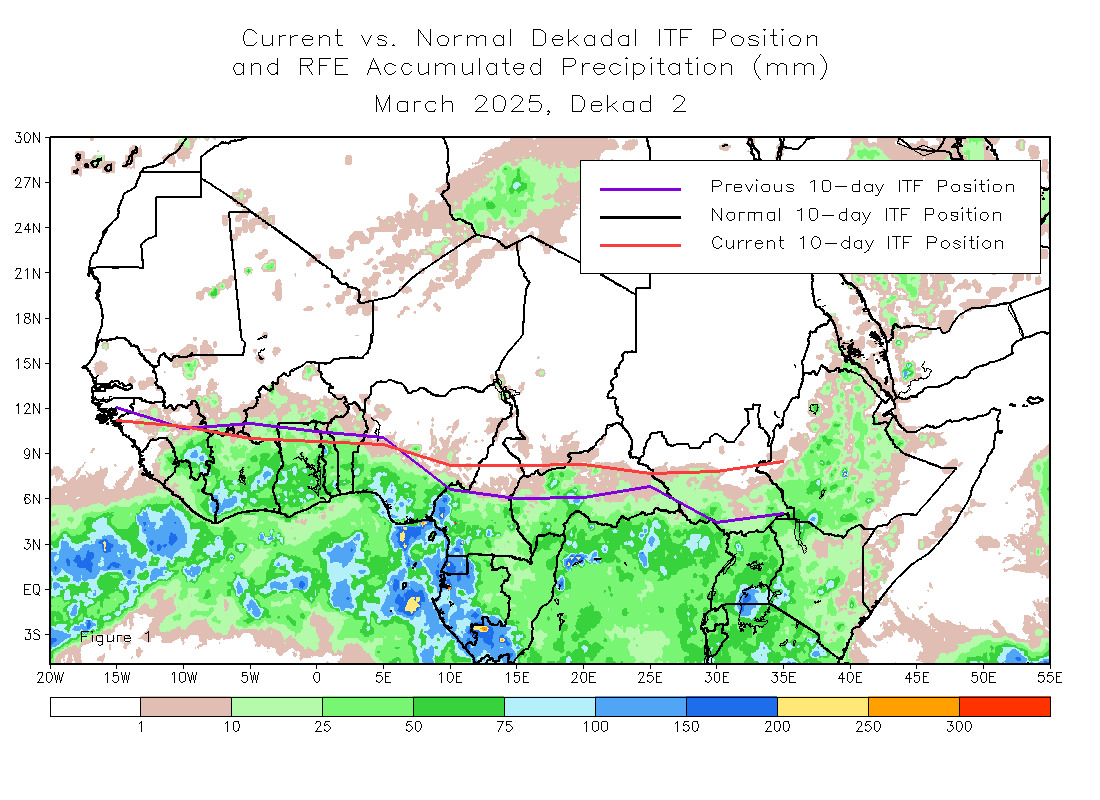
Danny Morris has it correct, while accuweather goofed here. The ITCZ is and has been anomalously far north for the last few weeks. Because of this, tropical waves are tracking across Africa further north. The result of tropical waves tracking further north is that they tend to pick up more dust and dry air that stabilizes the atmosphere and are sending it out over the Atlantic ahead and behind them. This is why tropical cyclone formation has been a hard feat to achieve out over the Atlantic as of late and may very well continue to be an issue through peak season unless we see the ITCZ shift southward and ridging over Europe (which is also helping pump dry air out over the Atlantic) collapses.
2 likes
Who is online
Users browsing this forum: No registered users and 157 guests