2020 Global Model Runs Discussion (Out thru day 16)
Moderator: S2k Moderators
Forum rules

The posts in this forum are NOT official forecasts and should not be used as such. They are just the opinion of the poster and may or may not be backed by sound meteorological data. They are NOT endorsed by any professional institution or STORM2K. For official information, please refer to products from the National Hurricane Center and National Weather Service.

Re: 2020 Global Model Runs Discussion (Out thru day 16)
The models showing this type of hyperactivity is very worrying especially looking at real time. The real hurricane season is here and it doesn't look like its going to slow down anytime soon!
3 likes

Re: 2020 Global Model Runs Discussion (Out thru day 16)
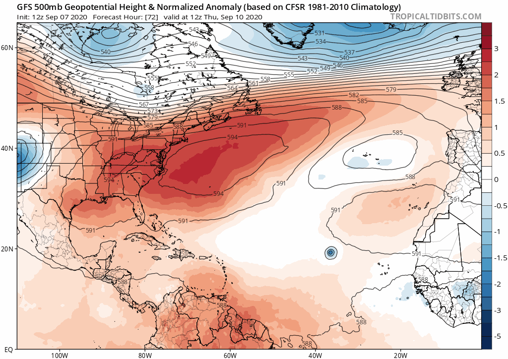
gatorcane wrote:The 12Z GFS shows a very progressive 500mb pattern with each trough getting progressively stronger as well. Difficult to get the current Cape Verde storms anywhere close to the CONUS with this pattern. Something would have to be very far south and travel through the Caribbean recurving across the Western Caribbean:
https://i.postimg.cc/fTWP5gRJ/gfs-z500a-Norm-atl-fh72-300.gif
After yet again failing with the trough pattern for next you still believe the GFS past its 120 hr forecast range?

7 likes

Re: 2020 Global Model Runs Discussion (Out thru day 16)
Today's 12z Euro run is similar to today's 12z GFS in that it shows hyperactivity over the next 1-2 weeks, as well as Paulette and Rene sticking around for over a week. However, it shows a new TC developing from another wave that emerges a day or two after future Sally. This is a new disturbance that didn't appear on any models prior to today or last night. The run ends with Paulette, Rene, Sally, Teddy, and Vicky all active simultaneously with a Fuijwhara interaction between Rene and Teddy -- an exceptionally rare scenario if this were to play out.


7 likes
Irene '11 Sandy '12 Hermine '16 5/15/2018 Derecho Fay '20 Isaias '20 Elsa '21 Henri '21 Ida '21
I am only a meteorology enthusiast who knows a decent amount about tropical cyclones. Look to the professional mets, the NHC, or your local weather office for the best information.
I am only a meteorology enthusiast who knows a decent amount about tropical cyclones. Look to the professional mets, the NHC, or your local weather office for the best information.
-
gatorcane

- S2K Supporter

- Posts: 23708
- Age: 48
- Joined: Sun Mar 13, 2005 3:54 pm
- Location: Boca Raton, FL
Re: 2020 Global Model Runs Discussion (Out thru day 16)
NDG wrote:gatorcane wrote:The 12Z GFS shows a very progressive 500mb pattern with each trough getting progressively stronger as well. Difficult to get the current Cape Verde storms anywhere close to the CONUS with this pattern. Something would have to be very far south and travel through the Caribbean recurving across the Western Caribbean:
https://i.postimg.cc/fTWP5gRJ/gfs-z500a-Norm-atl-fh72-300.gif
After yet again failing with the trough pattern for next you still believe the GFS past its 120 hr forecast range?
https://i.imgur.com/jj3Tbmj.gif
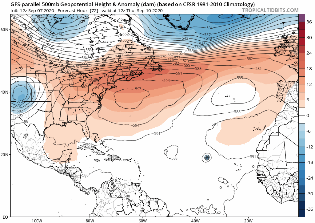
Yes I do believe we are entering more of a fall pattern. The hour glass is emptying each day to allow any of these Cape Verde storms across unless one can stay way south. Here is the GFS parallel animation of 500MB heights for comparison to the old GFS:
1 likes
-
SouthFLTropics

- Category 5

- Posts: 4258
- Age: 50
- Joined: Thu Aug 14, 2003 8:04 am
- Location: Port St. Lucie, Florida
Re: 2020 Global Model Runs Discussion (Out thru day 16)
Today’s 12z Euro is crazy. We’re going to need a cop out in the Central Atlantic to direct traffic.
Sent from my iPhone using Tapatalk
Sent from my iPhone using Tapatalk
5 likes
Fourth Generation Florida Native
Personal Storm History: David 79, Andrew 92, Erin 95, Floyd 99, Irene 99, Frances 04, Jeanne 04, Wilma 05, Matthew 16, Irma 17, Ian 22, Nicole 22, Milton 24
Personal Storm History: David 79, Andrew 92, Erin 95, Floyd 99, Irene 99, Frances 04, Jeanne 04, Wilma 05, Matthew 16, Irma 17, Ian 22, Nicole 22, Milton 24
-
CrazyC83
- Professional-Met

- Posts: 34315
- Joined: Tue Mar 07, 2006 11:57 pm
- Location: Deep South, for the first time!
Re: 2020 Global Model Runs Discussion (Out thru day 16)
SouthFLTropics wrote:Today’s 12z Euro is crazy. We’re going to need a cop out in the Central Atlantic to direct traffic.
Sent from my iPhone using Tapatalk
In that pattern, I suspect Sally would be the one that breaks all the way. It would have open water farther west. Paulette could make a break if it stays weak in the short term and doesn't pick up the flow from Rene or the upper-level trough. The others look to go into a square dance.
Last edited by CrazyC83 on Mon Sep 07, 2020 4:28 pm, edited 1 time in total.
1 likes
-
SouthFLTropics
- Category 5
- Posts: 4258
- Age: 50
- Joined: Thu Aug 14, 2003 8:04 am
- Location: Port St. Lucie, Florida
Re: 2020 Global Model Runs Discussion (Out thru day 16)
CrazyC83 wrote:SouthFLTropics wrote:Today’s 12z Euro is crazy. We’re going to need a cop out in the Central Atlantic to direct traffic.
Sent from my iPhone using Tapatalk
In that pattern, I suspect Sally would be the one that breaks all the way. It would have open water farther west.
Whoa...Sally, whew that girl.
Sent from my iPhone using Tapatalk
0 likes
Fourth Generation Florida Native
Personal Storm History: David 79, Andrew 92, Erin 95, Floyd 99, Irene 99, Frances 04, Jeanne 04, Wilma 05, Matthew 16, Irma 17, Ian 22, Nicole 22, Milton 24
Personal Storm History: David 79, Andrew 92, Erin 95, Floyd 99, Irene 99, Frances 04, Jeanne 04, Wilma 05, Matthew 16, Irma 17, Ian 22, Nicole 22, Milton 24

Re: 2020 Global Model Runs Discussion (Out thru day 16)
aspen wrote:Today's 12z Euro run is similar to today's 12z GFS in that it shows hyperactivity over the next 1-2 weeks, as well as Paulette and Rene sticking around for over a week. However, it shows a new TC developing from another wave that emerges a day or two after future Sally. This is a new disturbance that didn't appear on any models prior to today or last night. The run ends with Paulette, Rene, Sally, Teddy, and Vicky all active simultaneously with a Fuijwhara interaction between Rene and Teddy -- an exceptionally rare scenario if this were to play out.
https://i.imgur.com/zIcYuCb.png
https://i.imgur.com/gSgBB12.png
https://i.imgur.com/CJArYq1.png
https://i.imgur.com/ng6G7tC.png
https://i.imgur.com/hJxeDJt.png
Had to comment on this after doing a comparison to 2005--if anything like this run plays out, Sally would be headed into Rita timing and possible environment given this where Isasas and Laura really started taking off.
1 likes
The above post is not official and should not be used as such. It is the opinion of the poster and may or may not be backed by sound meteorological data. It is not endorsed by any professional institution or storm2k.org. For official information, please refer to the NHC and NWS products.
-
CrazyC83
- Professional-Met
- Posts: 34315
- Joined: Tue Mar 07, 2006 11:57 pm
- Location: Deep South, for the first time!
Re: 2020 Global Model Runs Discussion (Out thru day 16)
Hammy wrote:aspen wrote:Today's 12z Euro run is similar to today's 12z GFS in that it shows hyperactivity over the next 1-2 weeks, as well as Paulette and Rene sticking around for over a week. However, it shows a new TC developing from another wave that emerges a day or two after future Sally. This is a new disturbance that didn't appear on any models prior to today or last night. The run ends with Paulette, Rene, Sally, Teddy, and Vicky all active simultaneously with a Fuijwhara interaction between Rene and Teddy -- an exceptionally rare scenario if this were to play out.
https://i.imgur.com/zIcYuCb.png
https://i.imgur.com/gSgBB12.png
https://i.imgur.com/CJArYq1.png
https://i.imgur.com/ng6G7tC.png
https://i.imgur.com/hJxeDJt.png
Had to comment on this after doing a comparison to 2005--if anything like this run plays out, Sally would be headed into Rita timing and possible environment given this where Isasas and Laura really started taking off.
Either that, or would have a straightaway into the east coast with warm water near the Bahamas.
0 likes
-
TheStormExpert
Re: 2020 Global Model Runs Discussion (Out thru day 16)
NDG wrote:gatorcane wrote:The 12Z GFS shows a very progressive 500mb pattern with each trough getting progressively stronger as well. Difficult to get the current Cape Verde storms anywhere close to the CONUS with this pattern. Something would have to be very far south and travel through the Caribbean recurving across the Western Caribbean:
https://i.postimg.cc/fTWP5gRJ/gfs-z500a-Norm-atl-fh72-300.gif
After yet again failing with the trough pattern for next you still believe the GFS past its 120 hr forecast range?
https://i.imgur.com/jj3Tbmj.gif
This is not like the last five years where a strong Bermuda High was there to shove storms west regardless of how quickly the spin up. Currently there are no indications of a Bermuda High whatsoever. So unless something fails to quickly develop before 50-60°W longitude everything I more likely to recurve.
2 likes
-
cajungal

- Category 5
- Posts: 2354
- Age: 49
- Joined: Sun Mar 14, 2004 9:34 pm
- Location: Schriever, Louisiana (60 miles southwest of New Orleans)
Re: 2020 Global Model Runs Discussion (Out thru day 16)
I think the position of mustang Sally makes me a little nervous
1 likes
-
AutoPenalti
- Category 5
- Posts: 4091
- Age: 29
- Joined: Mon Aug 17, 2015 4:16 pm
- Location: Ft. Lauderdale, Florida
Re: 2020 Global Model Runs Discussion (Out thru day 16)
My brain hurts just trying to track one of these TC’s...
4 likes
The posts in this forum are NOT official forecasts and should not be used as such. They are just the opinion of the poster and may or may not be backed by sound meteorological data. They are NOT endorsed by any professional institution or STORM2K. For official information, please refer to products from the NHC and NWS.
Model Runs Cheat Sheet:
GFS (5:30 AM/PM, 11:30 AM/PM)
HWRF, GFDL, UKMET, NAVGEM (6:30-8:00 AM/PM, 12:30-2:00 AM/PM)
ECMWF (1:45 AM/PM)
TCVN is a weighted averaged
-
SFLcane

- S2K Supporter
- Posts: 10281
- Age: 48
- Joined: Sat Jun 05, 2010 1:44 pm
- Location: Lake Worth Florida
Re: 2020 Global Model Runs Discussion (Out thru day 16)
TheStormExpert wrote:NDG wrote:gatorcane wrote:The 12Z GFS shows a very progressive 500mb pattern with each trough getting progressively stronger as well. Difficult to get the current Cape Verde storms anywhere close to the CONUS with this pattern. Something would have to be very far south and travel through the Caribbean recurving across the Western Caribbean:
https://i.postimg.cc/fTWP5gRJ/gfs-z500a-Norm-atl-fh72-300.gif
After yet again failing with the trough pattern for next you still believe the GFS past its 120 hr forecast range?
https://i.imgur.com/jj3Tbmj.gif
This is not like the last five years where a strong Bermuda High was there to shove storms west regardless of how quickly the spin up. Currently there are no indications of a Bermuda High whatsoever. So unless something fails to quickly develop before 50-60°W longitude everything I more likely to recurve.
Careful.. EPS does have more ridging Day10-12 now.
0 likes
-
TheStormExpert
Re: 2020 Global Model Runs Discussion (Out thru day 16)
SFLcane wrote:TheStormExpert wrote:NDG wrote:
After yet again failing with the trough pattern for next you still believe the GFS past its 120 hr forecast range?
https://i.imgur.com/jj3Tbmj.gif
This is not like the last five years where a strong Bermuda High was there to shove storms west regardless of how quickly the spin up. Currently there are no indications of a Bermuda High whatsoever. So unless something fails to quickly develop before 50-60°W longitude everything I more likely to recurve.
Careful.. EPS does have more ridging Day10-12 now.
Still the pattern is progressive.
1 likes
Re: 2020 Global Model Runs Discussion (Out thru day 16)
gatorcane wrote:NDG wrote:gatorcane wrote:The 12Z GFS shows a very progressive 500mb pattern with each trough getting progressively stronger as well. Difficult to get the current Cape Verde storms anywhere close to the CONUS with this pattern. Something would have to be very far south and travel through the Caribbean recurving across the Western Caribbean:
https://i.postimg.cc/fTWP5gRJ/gfs-z500a-Norm-atl-fh72-300.gif
After yet again failing with the trough pattern for next you still believe the GFS past its 120 hr forecast range?
https://i.imgur.com/jj3Tbmj.gif
Yes I do believe we are entering more of a fall pattern. The hour glass is emptying each day to allow any of these Cape Verde storms across unless one can stay way south. Here is the GFS parallel animation of 500MB heights for comparison to the old GFS:
https://i.postimg.cc/VLYxvpz4/gfsp-z500a-atl-fh72-300.gif
Is way too early to give the all clear from the CV storms threatening the US with a parade of storms lining up, one or two may find a break in the ridge but the ones following may not.
Last month you posted about the Bermuda ridge not being present this summer then a week later LA got hit by a Cat 4 hurricane because of the Bermuda ridge. I hope you are not jinxing us again
10 likes
-
DestinHurricane

- Category 4

- Posts: 935
- Joined: Tue May 01, 2018 8:05 am
- Location: New York, NY
Re: 2020 Global Model Runs Discussion (Out thru day 16)
TheStormExpert wrote:NDG wrote:gatorcane wrote:The 12Z GFS shows a very progressive 500mb pattern with each trough getting progressively stronger as well. Difficult to get the current Cape Verde storms anywhere close to the CONUS with this pattern. Something would have to be very far south and travel through the Caribbean recurving across the Western Caribbean:
https://i.postimg.cc/fTWP5gRJ/gfs-z500a-Norm-atl-fh72-300.gif
After yet again failing with the trough pattern for next you still believe the GFS past its 120 hr forecast range?
https://i.imgur.com/jj3Tbmj.gif
This is not like the last five years where a strong Bermuda High was there to shove storms west regardless of how quickly the spin up. Currently there are no indications of a Bermuda High whatsoever. So unless something fails to quickly develop before 50-60°W longitude everything I more likely to recurve.
We are entering a strong +NAO and some models are hinting at ridge building back west. What exactly do you mean there is no bermuda high?
2 likes
Michael 2018
Re: 2020 Global Model Runs Discussion (Out thru day 16)
TheStormExpert wrote:NDG wrote:gatorcane wrote:The 12Z GFS shows a very progressive 500mb pattern with each trough getting progressively stronger as well. Difficult to get the current Cape Verde storms anywhere close to the CONUS with this pattern. Something would have to be very far south and travel through the Caribbean recurving across the Western Caribbean:
https://i.postimg.cc/fTWP5gRJ/gfs-z500a-Norm-atl-fh72-300.gif
After yet again failing with the trough pattern for next you still believe the GFS past its 120 hr forecast range?
https://i.imgur.com/jj3Tbmj.gif
This is not like the last five years where a strong Bermuda High was there to shove storms west regardless of how quickly the spin up. Currently there are no indications of a Bermuda High whatsoever. So unless something fails to quickly develop before 50-60°W longitude everything I more likely to recurve.
The trend by the EPS is for a strong Bermuda ridge from its previous long range forecast as it gets into its medium range. And I keep saying that 2017 did not see a strong Bermuda ridge as you might have thought during the heart of the Hurricane season, otherwise Irma, Jose, Maria.., would had all tracked further west.
The same thing with Dorian last year.


1 likes
-
AxaltaRacing24
- Category 5
- Posts: 1774
- Age: 25
- Joined: Wed Jul 27, 2016 11:14 am
- Location: Jupiter, FL
Re: 2020 Global Model Runs Discussion (Out thru day 16)
AutoPenalti wrote:My brain hurts just trying to track one of these TC’s...
2020 is an absolute headache.
1 likes
-
Blown Away

- S2K Supporter
- Posts: 10253
- Joined: Wed May 26, 2004 6:17 am
Re: 2020 Global Model Runs Discussion (Out thru day 16)
If there are 2-3 systems below 30N and E of 70W and a system moves off Africa @11N it’s going to very likely make at least 70W before any recurve.
0 likes
Hurricane Eye Experience: David 79, Irene 99, Frances 04, Jeanne 04, Wilma 05… Hurricane Brush Experience: Andrew 92, Erin 95, Floyd 99, Matthew 16, Irma 17, Ian 22, Nicole 22…

Re: 2020 Global Model Runs Discussion (Out thru day 16)
gatorcane wrote:The 12Z GFS shows a very progressive 500mb pattern with each trough getting progressively stronger as well. Difficult to get the current Cape Verde storms anywhere close to the CONUS with this pattern. Something would have to be very far south and travel through the Caribbean recurving across the Western Caribbean:
https://i.postimg.cc/fTWP5gRJ/gfs-z500a-Norm-atl-fh72-300.gif
The GFS has taken a toll on your otherwise stellar reputation (at least it is with me) this season. We aren’t moving steadily into Fall. We haven’t in many, many years. Expect more landfalls. No chance we don’t get 2 and if anyone is offering odds, I’ll bet we still have 3.
6 likes
Who is online
Users browsing this forum: South Texas Storms and 136 guests