looks like some minor turning associated with the storm complex off the west coast of FL
http://www.ssd.noaa.gov/goes/east/carb/flash-vis.html
Gulf Homebrew? (Is invest 93L)
Moderator: S2k Moderators
Forum rules

The posts in this forum are NOT official forecasts and should not be used as such. They are just the opinion of the poster and may or may not be backed by sound meteorological data. They are NOT endorsed by any professional institution or STORM2K. For official information, please refer to products from the National Hurricane Center and National Weather Service.
Re: Gulf Homebrew? - 10%
0 likes
Re: Gulf Homebrew? - 10%
Port....its mentioned in some discuussions Ive read that a front may make its way into our state next week...what role do you see it playing on a potential tropical system near our coast? Do we stay dry and say bye-bye to rain?...would that push the rain away?..I want the rains to fall upon our state as much as everyone else...but Im curious.
Last edited by underthwx on Tue Aug 30, 2011 1:52 pm, edited 1 time in total.
0 likes
-
Nederlander
- S2K Supporter

- Posts: 1259
- Joined: Sat Jul 19, 2008 4:28 pm
- Location: Conroe, TX
Re: Gulf Homebrew? - 10%
This could be just what the doctor ordered! Greg's said all along that its going to take a tropical system to put a huge dent into this drought.. Bring it!
0 likes
-
Portastorm

- Storm2k Moderator

- Posts: 9955
- Age: 63
- Joined: Fri Jul 11, 2003 9:16 am
- Location: Round Rock, TX
- Contact:
Re: Gulf Homebrew? - 10%
underthwx wrote:Port....its mentioned in some discuussions Ive read that a front may make its way into our state next week...what role do you see it playing on a potential tropical system near our coast? Do we stay dry and say bye-bye to rain?
I think the more the warm-core system develops and stays close to the coast, the better chance its circulation can drag down the front. NWS says a trough over the Missouri Valley area is supposed to sharpen and help bring the cold front through the state ... I mean, who knows. Seems a bit early for a cold frontal passage, especially the way this summer has been. I haven't looked much at the rest of the nation and the progged weather.
I'm sure our pro mets here or our more astute amateurs can chime in as well!
0 likes
Any forecasts under my name are to be taken with a grain of salt. Get your best forecasts from the National Weather Service and National Hurricane Center.
-
Aric Dunn
- Category 5

- Posts: 21238
- Age: 43
- Joined: Sun Sep 19, 2004 9:58 pm
- Location: Ready for the Chase.
- Contact:
SE gulf there definitely looks like a weak low is starting to develop.
0 likes
Note: If I make a post that is brief. Please refer back to previous posts for the analysis or reasoning. I do not re-write/qoute what my initial post said each time.
If there is nothing before... then just ask
Space & Atmospheric Physicist, Embry-Riddle Aeronautical University,
I believe the sky is falling...
If there is nothing before... then just ask
Space & Atmospheric Physicist, Embry-Riddle Aeronautical University,
I believe the sky is falling...
-
StormClouds63
- Category 2

- Posts: 583
- Age: 62
- Joined: Tue May 13, 2008 11:56 am
- Location: Southwest Louisiana
Re: Gulf Homebrew? - 10%
From the local weather service here in Lake Charles:
LONG TERM...A REX BLOCK LOW FORMS OVER THE GULF IN RESPONSE TO
BLOCKING HIGH PRESSURE OVER THE MID-MISSISSIPPI VALLEY LATER THIS WEEK.
MODELS ARE IN BETTER AGREEMENT ON THIS SLOWLY DEVELOPING SYSTEM.
CHOSE TO GO WITH THE EUROPEAN MODEL WHICH IS MORE CONSERVATIVE IN
NOT WINDING THIS SYSTEM UP AS QUICKLY. KEPT RAIN CHANCES IN THE
CHANCE CATEGORY FOR NOW BUT THIS COULD MORPH INTO LIKELY CHANCES
AS WE WATCH GULF MOISTURE DEEPEN. ANY RAIN WILL BE MOST WELCOME.
First time I've come across the phrase "Rex Block Low." Anyway, they seem to be buying into the Euro solution ... at least for now. Set a record here on Monday with a high of 102.
0 likes

Re: Gulf Homebrew?
Portastorm wrote:FWIW .... JB tweeted late this morning that "Lee to be" will be an "ugly Labor Day forecast headache for the NW Gulf" and that he is alerting his energy clients that it'll be "slow moving" and a "stronger storm."
To his credit, two weeks ago he said the Labor Day period looked like prime development time in the GOM. Pattern recognition stuff, etc.
CMC would agree with him....agree a nice TS would do wonders for us.....
0 likes
Re: Gulf Homebrew? - 10%
Rex Block
A blocking pattern where there is an upper level high located directly north of a closed low...from the NHC glossary of terms..
A blocking pattern where there is an upper level high located directly north of a closed low...from the NHC glossary of terms..
Last edited by underthwx on Tue Aug 30, 2011 2:01 pm, edited 1 time in total.
0 likes
Re: Gulf Homebrew? - 10%
0 likes
-
cperez1549

- Tropical Low

- Posts: 12
- Age: 39
- Joined: Sun Jul 20, 2008 9:42 am
- Contact:
Re: Gulf Homebrew? - 10%
000
FXUS64 KBRO 301850
AFDBRO
AREA FORECAST DISCUSSION
NATIONAL WEATHER SERVICE BROWNSVILLE TX
150 PM CDT TUE AUG 30 2011
.SHORT TERM /TONIGHT THROUGH WEDNESDAY NIGHT/...DEEP SOUTH TEXAS
WILL BE TRANSITIONING TO A DIFFERENT WEATHER PATTERN IN THE SHORT
TERM...AS THE H5 UPSTREAM RIDGE FLATTENS AND BROAD LOW PRESSURE
TAKES OVER IN THE WESTERN HALF OF THE GULF OF MEXICO. WHILE THERE
COULD BE SOME TROPICAL CYCLONE IMPLICATIONS IN THE LONGER TERM...
DISCUSSED BELOW...FOR NOW THE CONCERN WILL BE MOISTURE MOVING UP
FROM THE SOUTH WHICH WILL BRING A PRETTY GOOD SHOT AT SOME RAIN
FOR AT LEAST PORTIONS...MAINLY EAST AND SOUTH...OF DEEP SOUTH
TEXAS.
DID NOT MAKE ANY MAJOR ALTERATIONS TO THE INHERITED FORECAST...
FOLLOWING THE REASONABLE ECMWF...THOUGH OTHER MODELS WERE NOT MUCH
DIFFERENT AT THIS JUNCTURE...BUT DUE TO THE PREFERENCE FOR THE ECMWF
IN THE LONG TERM FELT OVERALL CONTINUITY MIGHT BE BETTER. ALL IN
ALL...JUST REFRESHED SOME OF THE DATA...MAINTAINING THE INCREASING
POP TREND. KEPT SHOWERS OVER LAND MOSTLY...WITH THUNDERSHOWERS
RESERVED FOR THE MARINE AREAS FOR NOW. DAYTIME TEMPS WILL ALSO BE
MODERATED BY A COUPLE OF DEGREES...ALTHOUGH WE ARE STILL LOOKING AT
WARMER THAN NORMAL CONDITIONS OVERALL. WITH THE INCREASED RAIN
CHANCES WILL COME MORE CLOUDS...PARTLY TO MOSTLY CLOUDY AFTER
TONIGHT. WINDS WILL BE LIGHT TO MODERATE ONSHORE...MAINLY EAST.
.LONG TERM /THURSDAY THROUGH LABOR DAY/...PATTERN SHIFT MAY END UP
BEING MORE THAN WE BARGAINED FOR. THURSDAY WILL BE SIMILAR TO
WEDNESDAY AS DEEPER MOISTURE CONTINUES TO SPREAD INLAND ACROSS
SOUTH TEXAS. SHOULD SEE A FAIRLY ACTIVE SEABREEZE THURSDAY
AFTERNOON DRIFTING INLAND. ALL FOCUS FOR THE WEEKEND IS ON THE
TROPICAL WAVE CURRENTLY IN THE NW CARIBBEAN. MODELS ARE
CONSISTENT IN BRINGING THE WAVE INTO THE WESTERN DURING THE NEXT
COUPLE DAYS...BUT NOT DEVELOPING DUE TO SIGNIFICANT SHEAR
ENVIRONMENT. AFTER THURSDAY THE MODELS GO IN SIGNIFICANTLY
DIFFERENT DIRECTIONS ON SPEED...STRENGTH AND DIRECTION OF THE WAVE
IN THE NW GULF...WHICH IS BRINGING LONG TERM FORECAST CONFIDENCE
DOWN. MOST MODELS ARE WRAPPING NORTHERLY WINDS AROUND THE FEATURE
ACROSS SOUTH TEXAS FRIDAY. INCIDENTS LIKE THIS PREVIOUSLY HAVE
BROUGHT SKYROCKETING TEMPERATURES FOR THE VALLEY. RECORDS FOR
FRIDAY ARE EASILY REACHABLE IN THIS PATTERN. MOST MODELS SLOWLY
BRING THE FEATURE SOUTHWEST INTO SOUTH TEXAS LATER IN THE
WEEKEND...WITH GRADUALLY INCREASING PRECIP CHANCES SUNDAY AND
MONDAY. SATURATED FORECAST SOUNDINGS LEAD TO THREAT FOR HEAVY
DOWNPOURS IN THUNDERSTORMS THOSE DAYS. HAVE ALSO ADJUSTED WIND
FORECAST UPWARDS TO 20 TO 25 KNOTS FOR MOST OF THE REGION OVER
THE WEEKEND AS THE FEATURE WILL BE NEAR ENOUGH TO INCREASE LOCAL
GRADIENT FROM THE NORTH. ALL ARE URGED TO KEEP A CLOSE EYE TO THE
FORECAST FOR THE WEEKEND FOR ANY SIGNIFICANT CHANGES...ESPECIALLY
DURING THE LABOR DAY HOLIDAY WEEKEND.
0 likes

Re: Gulf Homebrew? - 10%
Looks like the persistent stratiform precip is drawing the anti-cyclone, that is to the west, closer to it.
http://tropic.ssec.wisc.edu/real-time/w ... oom=&time=
http://tropic.ssec.wisc.edu/real-time/w ... oom=&time=
0 likes
Re: Gulf Homebrew? - 10%
GCANE wrote:Looks like the persistent stratiform precip is drawing the anti-cyclone, that is to the west, closer to it.
http://tropic.ssec.wisc.edu/real-time/w ... oom=&time=
nice catch G......you are right....if that can center over the voracity then maybe help stack....
0 likes
Re: Gulf Homebrew? - 10%
underthwx wrote:Rex Block
A blocking pattern where there is an upper level high located directly north of a closed low...from the NHC glossary of terms..
Rex Blocks act to block the movement of systems.
This could mean the system stalls out in the GOM or somewhere close to the coast.
If so, the persistent rain may in fact lead to possible heavy flooding.
0 likes
Re: Gulf Homebrew? - 10%
0 likes
Re: Gulf Homebrew? - 10%
last night 0z GFS runs showed similar scenario...stalled low right off the coast for days.....another Allison? ugh....
0 likes
Re: Gulf Homebrew? - 10%
ROCK wrote:GCANE wrote:Looks like the persistent stratiform precip is drawing the anti-cyclone, that is to the west, closer to it.
http://tropic.ssec.wisc.edu/real-time/w ... oom=&time=
nice catch G......you are right....if that can center over the voracity then maybe help stack....
Thanks Rock.
Thunderstorms also starting to pop over northern Yucatan, which could also help move the anti-cyclone east.
http://www.atmos.washington.edu/~ovens/ ... nhanced+12
0 likes
Re: Gulf Homebrew? - 10%
underthwx wrote::uarrow: can someone put into a nutshell what the Brownsville mets are indicating?...in laymans terms?
Would not be a good scenario if this sits over one spot for a couple days.
0 likes
-
Stormcenter
- S2K Supporter
- Posts: 6689
- Joined: Wed Sep 03, 2003 11:27 am
- Location: Houston, TX
From this afternoon HPC's extended discussion:
OVER THE WRN GULF OF MEXICO... THERE IS CURRENTLY NO FEATURE FOR
WHICH THE NHC TROPICAL WEATHER OUTLOOK INDICATES CONCERN FOR
POTENTIAL DEVELOPMENT DURING THE NEXT TWO DAYS. HOWEVER BY THE
MEDIUM RANGE PERIOD THE AVERAGE OF ALL GUIDANCE OVER THE PAST 24
HRS HAS TRENDED STRONGER WITH A MID LVL WEAKNESS/POSSIBLE CLOSED
LOW AND ASSOC SFC LOW OVER THE WRN OR NRN GULF. THE 00Z AND YDAYS
12Z ECMWF RUNS WERE ON THE AGGRESSIVE SIDE OF THE ENVELOPE WITH
ITS DEVELOPMENT BUT THE NEW 12Z RUN IS MUCH WEAKER/MORE
SUPPRESSED. THE 06Z/12Z GFS ARE ON THE NERN SIDE OF THE ENVELOPE.
THE FINAL FCST INCORPORATES THE 17Z NHC/HPC COORDINATION FOR
TRACK/STRENGTH WITH AN INTERMEDIATE SOLN RECOMMENDED FOR BOTH
PARAMETERS.
THE FOCUS FOR HEAVIEST RNFL DURING THE PERIOD WILL LIKELY BE ALONG
THE GULF COAST IN ASSOC WITH THE BROAD AREA OF LOW PRESSURE FCST
TO EVOLVE OVER THE WRN HALF OF THE GULF OF MEXICO. CONFIDENCE IN
WHERE THE GREATEST IMPACT WILL BE IS FAIRLY LOW DUE TO THE CURRENT
SPREAD AMONG MODEL/ENSEMBLE SOLNS.
0 likes
Re: Gulf Homebrew? - 10%
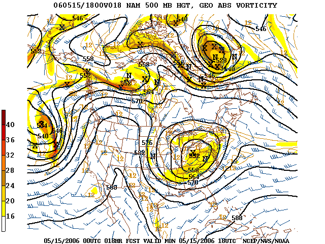
Blocks in meteorology are large scale patterns in the atmospheric pressure field that are nearly stationary, effectively "blocking" or redirecting migratory cyclones. They are also known as blocking highs or blocking anticyclones.[1] These blocks can remain in place for several days or even weeks, causing the areas affected by them to have the same kind of weather for an extended period of time (e.g.- precipitation for some areas, clear skies for others).[2] In the Northern Hemisphere, extended blocking occurs most frequently in the spring over the eastern Pacific and Atlantic oceans.[1]from wilkipedia
below image illustrates Rex Block
http://upload.wikimedia.org/wikipedia/c ... 500_MB.PNG
i did some research on rex block...thought i would post since it might be relevant to this event...also i found it interesting that it usally more of a springtime pattern....if this this is not relevant you may delete this..
The posts in this forum are NOT official forecast and should not be used as such. They are just the opinion of the poster and may or may not be backed by sound meteorological data. They are NOT endorsed by any professional institution or storm2k.org. For official information, please refer to the NHC and NWS products.
Last edited by underthwx on Tue Aug 30, 2011 2:43 pm, edited 1 time in total.
0 likes
Who is online
Users browsing this forum: No registered users and 131 guests