The CSU team of Dr Klotzbach/Dr Gray will release their August forecast next Friday and the three questions that loom in terms of the numbers are the following. Will they leave them the same? (18/9/4) Will they increase the numbers? Will they go down in the numbers? As we know,TSR already went down in the numbers by one citing cooler waters in MDR. See their July forecast at first post.
IMO,they will go down at least one on each category but still they will say in the abstract that an active season will occur.
Expert forecasts for 2013 N Atlantic season
Moderator: S2k Moderators
Forum rules

The posts in this forum are NOT official forecasts and should not be used as such. They are just the opinion of the poster and may or may not be backed by sound meteorological data. They are NOT endorsed by any professional institution or STORM2K. For official information, please refer to products from the National Hurricane Center and National Weather Service.
-
cycloneye

- Admin

- Posts: 149703
- Age: 69
- Joined: Thu Oct 10, 2002 10:54 am
- Location: San Juan, Puerto Rico
Re: Expert forecasts for 2013 N Atlantic season (See 1rst post)
0 likes
Visit the Caribbean-Central America Weather Thread where you can find at first post web cams,radars
and observations from Caribbean basin members Click Here
and observations from Caribbean basin members Click Here
-
cycloneye
- Admin
- Posts: 149703
- Age: 69
- Joined: Thu Oct 10, 2002 10:54 am
- Location: San Juan, Puerto Rico
Re: Expert forecasts for 2013 N Atlantic season (See 1rst post)
Here are some comments by Phil Klotzbach And Stan Goldenberg of NOAA that may give us a clue about how they will go in terms of the numbers next Friday and on August 8.
NOAA
"The fact that they formed there at all in July, even though they didn't last long, suggests that when we hit the peak months, things could be very favorable for development," said Stanley Goldenberg, a research meteorologist for the National Oceanic and Atmospheric Administration.
Phil Klotzbach of CSU
Some atmospheric factors could suppress systems, mainly dry air and cooler sea surface temperatures, said Phil Klotzbach, a Colorado State University climatologist.
"There are a lot of mixed signals out there," he said.
Klotzbach and William Gray, who in June predicted 18 named storms, including nine hurricanes, will update their seasonal forecast on Friday.
http://www.sun-sentinel.com/news/browar ... 5889.story
0 likes
Visit the Caribbean-Central America Weather Thread where you can find at first post web cams,radars
and observations from Caribbean basin members Click Here
and observations from Caribbean basin members Click Here
-
ninel conde
-
cycloneye
- Admin
- Posts: 149703
- Age: 69
- Joined: Thu Oct 10, 2002 10:54 am
- Location: San Juan, Puerto Rico
Re:
ninel conde wrote:Phils comments seem more sensible. time will tell. i will guess CSU will drop by 3 named storms, 2 hurricanes and 1 major and lower landfall probabilities.
My take is CSU will drop one number for each category to have 17/8/3 but let's wait until next Friday to see the forecast.
0 likes
Visit the Caribbean-Central America Weather Thread where you can find at first post web cams,radars
and observations from Caribbean basin members Click Here
and observations from Caribbean basin members Click Here
-
ninel conde
Re: Expert forecasts for 2013 N Atlantic season (See 1rst post)
cycloneye wrote:Here are some comments by Phil Klotzbach And Stan Goldenberg of NOAA that may give us a clue about how they will go in terms of the numbers next Friday and on August 8.
NOAA
"The fact that they formed there at all in July, even though they didn't last long, suggests that when we hit the peak months, things could be very favorable for development," said Stanley Goldenberg, a research meteorologist for the National Oceanic and Atmospheric Administration.
Phil Klotzbach of CSU
Some atmospheric factors could suppress systems, mainly dry air and cooler sea surface temperatures, said Phil Klotzbach, a Colorado State University climatologist.
"There are a lot of mixed signals out there," he said.
Klotzbach and William Gray, who in June predicted 18 named storms, including nine hurricanes, will update their seasonal forecast on Friday.
http://www.sun-sentinel.com/news/browar ... 5889.story
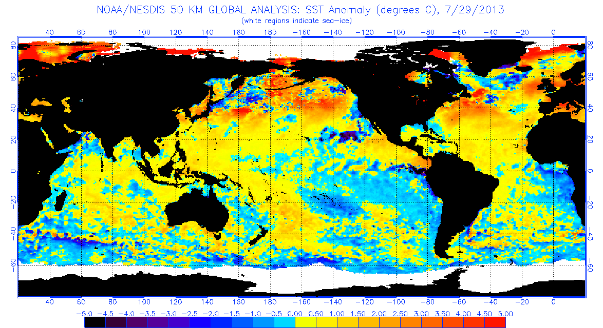
i have to disagree with phil about cooler SST's
http://www.ospo.noaa.gov/data/sst/anoma ... 9.2013.gif
they are above normal from the african coast to 65w. SST's can not be blamed for inactivity.
0 likes


Re: Expert forecasts for 2013 N Atlantic season (See 1rst post)
ninel conde wrote:cycloneye wrote:Here are some comments by Phil Klotzbach And Stan Goldenberg of NOAA that may give us a clue about how they will go in terms of the numbers next Friday and on August 8.
NOAA
"The fact that they formed there at all in July, even though they didn't last long, suggests that when we hit the peak months, things could be very favorable for development," said Stanley Goldenberg, a research meteorologist for the National Oceanic and Atmospheric Administration.
Phil Klotzbach of CSU
Some atmospheric factors could suppress systems, mainly dry air and cooler sea surface temperatures, said Phil Klotzbach, a Colorado State University climatologist.
"There are a lot of mixed signals out there," he said.
Klotzbach and William Gray, who in June predicted 18 named storms, including nine hurricanes, will update their seasonal forecast on Friday.
http://www.sun-sentinel.com/news/browar ... 5889.story
i have to disagree with phil about cooler SST's
http://www.ospo.noaa.gov/data/sst/anoma ... 9.2013.gif
they are above normal from the african coast to 65w. SST's can not be blamed for inactivity.
There was some cool SSTs in the NE Atlantic that many experts thought that it was going to move down to the MDR, but as we now know that did not happened. But the problem with the dry MDR is still there.
0 likes

-
cycloneye
- Admin
- Posts: 149703
- Age: 69
- Joined: Thu Oct 10, 2002 10:54 am
- Location: San Juan, Puerto Rico
Re:
Alyono wrote:The latest Cuban prediction is 18 storms and 9 canes
Do you have the link?
0 likes
Visit the Caribbean-Central America Weather Thread where you can find at first post web cams,radars
and observations from Caribbean basin members Click Here
and observations from Caribbean basin members Click Here
-
cycloneye
- Admin
- Posts: 149703
- Age: 69
- Joined: Thu Oct 10, 2002 10:54 am
- Location: San Juan, Puerto Rico
Re: Expert forecasts for 2013 N Atlantic season (See 1st post)
I have a medical appointment at 10 AM EDT on Friday around the same time CSU will release their August forecast. For that reason the posting at the first post list will be delayed until I get back to my PC. Maybe a fellow moderator adds it.  But anyone of course can post it here.
0 likes
Visit the Caribbean-Central America Weather Thread where you can find at first post web cams,radars
and observations from Caribbean basin members Click Here
and observations from Caribbean basin members Click Here
-
wxman57

- Moderator-Pro Met

- Posts: 23175
- Age: 68
- Joined: Sat Jun 21, 2003 8:06 pm
- Location: Houston, TX (southwest)
Re: Expert forecasts for 2013 N Atlantic season (See 1st post)
cycloneye wrote:I have a medical appointment at 10 AM EDT on Friday around the same time CSU will release their August forecast. For that reason the posting at the first post list will be delayed until I get back to my PC. Maybe a fellow moderator adds it.
I'm watching for it, Luis. Note that Phil Klotzbach is living in San Francisco now (his wife got a job with Clif Bars), so 10am EDT would be 7am PDT. Not sure he'll get it out that early.
See any dust there in PR from that SAL outbreak? Leading edge of thick dust is reaching you now.
0 likes
-
'CaneFreak

- Category 5

- Posts: 1487
- Joined: Mon Jun 05, 2006 10:50 am
- Location: New Bern, NC
The August CSU Forecast has just been released:
http://tropical.atmos.colostate.edu/for ... ug2013.pdf
18/8/3
They only lowered it by 1 hurricane and 1 major hurricane but...
We expect an above-average probability of United States and Caribbean major hurricane landfall.
http://tropical.atmos.colostate.edu/for ... ug2013.pdf
18/8/3
They only lowered it by 1 hurricane and 1 major hurricane but...
We expect an above-average probability of United States and Caribbean major hurricane landfall.
0 likes
-
ninel conde
Re:
'CaneFreak wrote:The August CSU Forecast has just been released:
http://tropical.atmos.colostate.edu/for ... ug2013.pdf
18/8/3
They only lowered it by 1 hurricane and 1 major hurricane but...
We expect an above-average probability of United States and Caribbean major hurricane landfall.
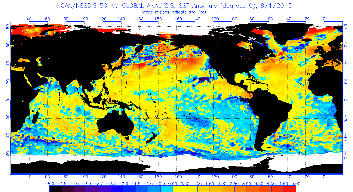
i can see lowered numbers due to dry air and below normal instability, but i dont get why they seem to think sst's are a problem
http://www.ospo.noaa.gov/data/sst/anoma ... 1.2013.gif
almost the entire atlantic is above normal.
0 likes
-
tolakram
- Admin
- Posts: 20186
- Age: 62
- Joined: Sun Aug 27, 2006 8:23 pm
- Location: Florence, KY (name is Mark)
Re: Re:
ninel conde wrote:
i can see lowered numbers due to dry air and below normal instability, but i dont get why they seem to think sst's are a problem
http://www.ospo.noaa.gov/data/sst/anoma ... 1.2013.gif
almost the entire atlantic is above normal.
Yellow is normal, and most of the MDR is yellow to just slightly above. IMO
All they are saying is part of the reason they had higher numbers was due to much warmer SST, which no longer exist.
0 likes
M a r k
- - - - -
Join us in chat: Storm2K Chatroom Invite. Android and IOS apps also available.
The posts in this forum are NOT official forecasts and should not be used as such. Posts are NOT endorsed by any professional institution or STORM2K.org. For official information and forecasts, please refer to NHC and NWS products.

Re:
'CaneFreak wrote:The August CSU Forecast has just been released:
http://tropical.atmos.colostate.edu/for ... ug2013.pdf
18/8/3
They only lowered it by 1 hurricane and 1 major hurricane but...
We expect an above-average probability of United States and Caribbean major hurricane landfall.
I would say things are fixing to get really interesting. I can see us tracking multiple storms at one time very soon...
0 likes
-
cycloneye
- Admin
- Posts: 149703
- Age: 69
- Joined: Thu Oct 10, 2002 10:54 am
- Location: San Juan, Puerto Rico
Re: Expert forecasts for 2013 season (CSU posted at 1rst post)
I find the CSU August forecast very good as I expected with a slight reduction but overall a very dangerous season looks like a given.
0 likes
Visit the Caribbean-Central America Weather Thread where you can find at first post web cams,radars
and observations from Caribbean basin members Click Here
and observations from Caribbean basin members Click Here
-
cycloneye
- Admin
- Posts: 149703
- Age: 69
- Joined: Thu Oct 10, 2002 10:54 am
- Location: San Juan, Puerto Rico
Re: Expert forecasts for 2013 N Atlantic season (See 1st post)
wxman57 wrote:cycloneye wrote:I have a medical appointment at 10 AM EDT on Friday around the same time CSU will release their August forecast. For that reason the posting at the first post list will be delayed until I get back to my PC. Maybe a fellow moderator adds it.
I'm watching for it, Luis. Note that Phil Klotzbach is living in San Francisco now (his wife got a job with Clif Bars), so 10am EDT would be 7am PDT. Not sure he'll get it out that early.
See any dust there in PR from that SAL outbreak? Leading edge of thick dust is reaching you now.
Very gray sky here with visibility around 7 miles.
0 likes
Visit the Caribbean-Central America Weather Thread where you can find at first post web cams,radars
and observations from Caribbean basin members Click Here
and observations from Caribbean basin members Click Here
-
cycloneye
- Admin
- Posts: 149703
- Age: 69
- Joined: Thu Oct 10, 2002 10:54 am
- Location: San Juan, Puerto Rico
Re: Expert forecasts for 2013 season (CSU up at 1rst post)
This week we will have more expert private firms and Government updating their forecasts among them TSR on the 6th and NOAA on the 8th.
0 likes
Visit the Caribbean-Central America Weather Thread where you can find at first post web cams,radars
and observations from Caribbean basin members Click Here
and observations from Caribbean basin members Click Here
Who is online
Users browsing this forum: Ulf and 157 guests