2018 Tropics: Global Model Runs Discussion (Out to day 16)
Moderator: S2k Moderators
Forum rules

The posts in this forum are NOT official forecasts and should not be used as such. They are just the opinion of the poster and may or may not be backed by sound meteorological data. They are NOT endorsed by any professional institution or STORM2K. For official information, please refer to products from the National Hurricane Center and National Weather Service.
-
BYG Jacob
Re: 2018 Tropics: Global Model Runs Discussion (Out to day 16)
Looks like an early start this year, yikes. Hopefully it isn't a sign of things to come this season.
1 likes
-
TheStormExpert
Re: 2018 Tropics: Global Model Runs Discussion (Out to day 16)
Like I thought, the GFS has the right idea of showing development just too soon and it looks like it may happen just before Memorial Day if trends continue. Hard to ignore the MJO when it’s in phases 1 and 2.
2 likes
-
srainhoutx

- S2K Supporter

- Posts: 6919
- Age: 68
- Joined: Sun Jan 14, 2007 11:34 am
- Location: Haywood County, NC
- Contact:
Re: 2018 Tropics: Global Model Runs Discussion (Out to day 16)
cycloneye wrote:@pppapin
Putting aside the #GFS fantasy canes beyond forecast day 10, the low-level westerlies forecast to develop next week over the EPAC is a favorable pattern for a large-scale circulation (i.e., a #CentralAmericanGyre) to develop.
This idea is supported by both the ECMWF & GFS.
https://twitter.com/pppapin/status/995426333852237824
I mentioned yesterday on the KHOU Board that the GFS was likely sniffing out our typical early season CAG aka known as a monsoonal gyre. Yesterday the 00Z ECMWF began to indicate the same possibility and that trend increased throughout the past 24 hours. For those that dismiss the GFS/GEFS solutions in the longer range, this serves as a reminder our tools are getting better and that one should inspect all the perimeters of our computer guidance. The Central America Gyre as been studied for a while thanks to Philippe and typically our early season mischief comes from such gyres and are usually slow to develop.
0 likes
Carla/Alicia/Jerry(In The Eye)/Michelle/Charley/Ivan/Dennis/Katrina/Rita/Wilma/Ike/Harvey
Member: National Weather Association
Wx Infinity Forums
http://wxinfinity.com/index.php
Facebook.com/WeatherInfinity
Twitter @WeatherInfinity
Member: National Weather Association
Wx Infinity Forums
http://wxinfinity.com/index.php
Facebook.com/WeatherInfinity
Twitter @WeatherInfinity
-
bamajammer4eva
- Category 4

- Posts: 907
- Joined: Sun Apr 18, 2010 3:21 am
- Location: Ozark, AL
Re: 2018 Tropics: Global Model Runs Discussion (Out to day 16)
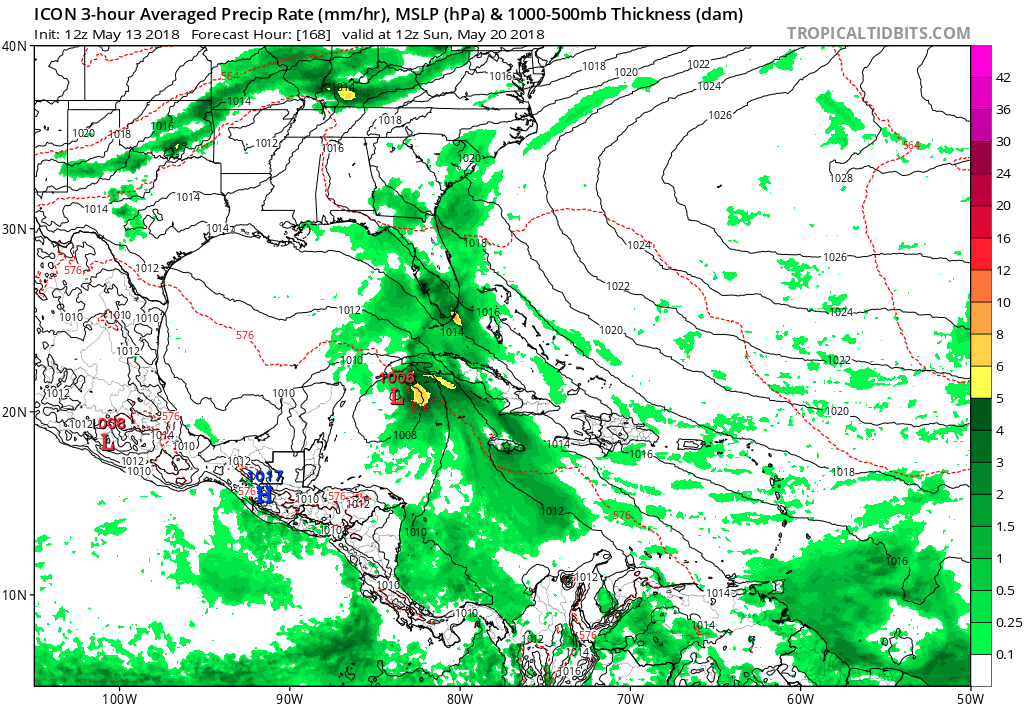
ICON also shows a Caribbean low @126H that later develops to 1005mb. It also has the Subtropical(?) feature in the NE Gulf mid week this week. While neither are probably very likely, it would be quite a preseason appetizer to get 2 classified systems going in May. BTW latest parallel GFS get Gulf low to 999 coming ashore near PCB
ICON
https://www.tropicaltidbits.com/analysi ... 300&fh=240
ICON
https://www.tropicaltidbits.com/analysi ... 300&fh=240
0 likes
-
USTropics
- Professional-Met

- Posts: 2738
- Joined: Sun Aug 12, 2007 3:45 am
- Location: Florida State University
Re: 2018 Tropics: Global Model Runs Discussion (Out to day 16)
Jeff Master's thoughts on the long-range Caribbean system:

The GFS model has also been predicting during much of the past week that an area of disturbed weather over Central America could act as the seed to get a tropical storm spinning in the Western Caribbean 7 – 12 days from now. Water temperatures there are near 28°C (82°F)—plenty warm enough to support a hurricane. The subtropical jet stream—which is typically located over the Caribbean in May, creating high wind shear that interferes with hurricane development—is predicted to lift northwards by late in the week, creating conditions favorable for tropical cyclone genesis. However, the long range runs of the European model have not been supporting this idea, and this is too far in the future to make reliable genesis forecasts. Thus, the GFS forecasts of a tropical storm in the Caribbean in 7 – 12 days should be viewed at this point as interesting, but improbable.
Figure 2. Sea surface temperatures (SSTs) off the coast of the Florida Panhandle are near 25°C (77°F)—a little cooler than is typically needed to see a tropical depression form, but plenty warm enough to support formation of a subtropical depression. SSTs in the Western Caribbean are near 28°C (82°F)—plenty warm enough to support a hurricane. Image credit: Levi Cowan, tropicaltidbits.com.
The GFS model has also been predicting during much of the past week that an area of disturbed weather over Central America could act as the seed to get a tropical storm spinning in the Western Caribbean 7 – 12 days from now. Water temperatures there are near 28°C (82°F)—plenty warm enough to support a hurricane. The subtropical jet stream—which is typically located over the Caribbean in May, creating high wind shear that interferes with hurricane development—is predicted to lift northwards by late in the week, creating conditions favorable for tropical cyclone genesis. However, the long range runs of the European model have not been supporting this idea, and this is too far in the future to make reliable genesis forecasts. Thus, the GFS forecasts of a tropical storm in the Caribbean in 7 – 12 days should be viewed at this point as interesting, but improbable.
0 likes
-
gatorcane

- S2K Supporter
- Posts: 23708
- Age: 48
- Joined: Sun Mar 13, 2005 3:54 pm
- Location: Boca Raton, FL
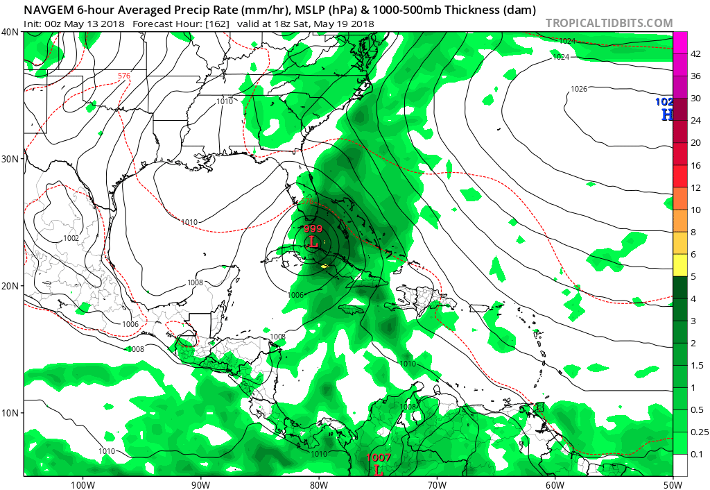
Re: 2018 Tropics: Global Model Runs Discussion (Out to day 16)
00Z NAVGEM on board with development:
0 likes
-
Shell Mound
- Category 5

- Posts: 2432
- Age: 33
- Joined: Thu Sep 07, 2017 3:39 pm
- Location: St. Petersburg, FL → Scandinavia
Re: 2018 Tropics: Global Model Runs Discussion (Out to day 16)
Good explanation of the pronounced early-season Caribbean TCG bias in the G(E)FS:
https://twitter.com/MJVentrice/status/995266379631775744
https://twitter.com/MJVentrice/status/995266837557456896
https://twitter.com/MJVentrice/status/995268833840594944
https://twitter.com/MJVentrice/status/995269244102369281
https://twitter.com/MJVentrice/status/995269756751089665
...
The FV3 at one point even showed a major hurricane hitting Chesapeake Bay on 26 May
https://twitter.com/asburybrandon5/status/995369505382596608
2 likes
CVW / MiamiensisWx / Shell Mound
The posts in this forum are NOT official forecasts and should not be used as such. They are just the opinion of the poster and may or may not be backed by sound meteorological data. They are NOT endorsed by any professional institution or STORM2K. For official information, please refer to products from the NHC and NWS.
-
gatorcane
- S2K Supporter
- Posts: 23708
- Age: 48
- Joined: Sun Mar 13, 2005 3:54 pm
- Location: Boca Raton, FL
Re: 2018 Tropics: Global Model Runs Discussion (Out to day 16)
Anyway some kind of gyre that could spark genesis in the Western Caribbean looks quite possible now in my opinion.
0 likes
-
wxman57

- Moderator-Pro Met

- Posts: 23172
- Age: 68
- Joined: Sat Jun 21, 2003 8:06 pm
- Location: Houston, TX (southwest)
Re: 2018 Tropics: Global Model Runs Discussion (Out to day 16)
gatorcane wrote::uarrow: except the GFS is showing a stronger cyclone in the past couple of runs again. I don’t remember too many spurious cyclones by the GFS last year (especially in May). If anything we were all talking about how the new GFS a year ago might be too conservative after the tweaks made.
Anyway some kind of gyre that could spark genesis in the Western Caribbean looks quite possible now in my opinion.
But it's always developing the storm later in time. A week ago, it was the 22nd of May. Now it's the 28th. Phantom.
3 likes
Re: 2018 Tropics: Global Model Runs Discussion (Out to day 16)
most models are now indicating some development in the Caribbean. It's no longer just the GFS. It's basically everything not named EC (cannot say if UK does or does not as it only goes out 7 days)
1 likes
-
gatorcane
- S2K Supporter
- Posts: 23708
- Age: 48
- Joined: Sun Mar 13, 2005 3:54 pm
- Location: Boca Raton, FL
Re: 2018 Tropics: Global Model Runs Discussion (Out to day 16)
The latest GFS shows genesis around May 22nd still. I looked back at previous runs going back to last weekend and some showed genesis sooner some later. Would be nice to see the timeframe come in within 1 week as I am not entirely convinced something will end up developing. But I don’t recall GFS phantoms staying around in the runs for a week straight like this not to mention a couple of other models albeit less reliable and proven have it too (ICON see below):
0 likes
-
gatorcane
- S2K Supporter
- Posts: 23708
- Age: 48
- Joined: Sun Mar 13, 2005 3:54 pm
- Location: Boca Raton, FL
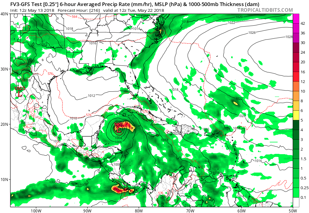
Re: 2018 Tropics: Global Model Runs Discussion (Out to day 16)
FV3 GFS coming in more bullish:
0 likes
Re: 2018 Tropics: Global Model Runs Discussion (Out to day 16)
gatorcane wrote:The latest GFS shows genesis around May 22nd still. I looked back at previous runs going back to last weekend and some showed genesis sooner some later. Would be nice to see the timeframe come in within 1 week as I am not entirely convinced something will end up developing. But I don’t recall GFS phantoms staying around in the runs for a week straight like this not to mention a couple of other models albeit less reliable and proven have it too (ICON see below):
1. The runs early to mid last week were consistently developing it on or around 5/18-9. That's why I was then analyzing W Car geneses during 5/11-20 instead of during 5/21-31. Now the geneses seem to be centered around 5/20-2.
2. The only place I've seen GFS phantoms sticking around for a week with no forecast time slippage was, interestingly enough, in the W Car. though that was more later season than early season. You can check old threads here to confirm. That's why I think there is a good side to mentioning TC geneses way out in time. We can look back.
3. Regarding the GFS runs that have had cat 2+ strength, don't forget that the GFS on numerous runs had Irma near or I think even below 900 mbs in some cases between Cuba and S FL. Those runs turned out to be close to 30 mb too strong.
4. I continue to think there is a low % as opposed to zero % threat to FL in late May from a W Car genesis though not of the crazy strengths many GFS runs have been showing. I think any FL storm would very likely be no stronger than TS. This takes into account both climo and the tendency of the GFS to overstrengthen last season.
2 likes
Personal Forecast Disclaimer:
The posts in this forum are NOT official forecasts and should not be used as such. They are just the opinion of the poster and may or may not be backed by sound meteorological data. They are NOT endorsed by any professional institution or storm2k.org. For official information, please refer to the NHC and NWS products.
The posts in this forum are NOT official forecasts and should not be used as such. They are just the opinion of the poster and may or may not be backed by sound meteorological data. They are NOT endorsed by any professional institution or storm2k.org. For official information, please refer to the NHC and NWS products.
-
northjaxpro

- S2K Supporter
- Posts: 8900
- Joined: Mon Sep 27, 2010 11:21 am
- Location: Jacksonville, FL
Re: 2018 Tropics: Global Model Runs Discussion (Out to day 16)
1 likes
NEVER, EVER SAY NEVER in the tropics and weather in general, and most importantly, with life itself!!
________________________________________________________________________________________
Fay 2008 Beryl 2012 Debby 2012 Colin 2016 Hermine 2016 Julia 2016 Matthew 2016 Irma 2017 Dorian 2019
________________________________________________________________________________________
Fay 2008 Beryl 2012 Debby 2012 Colin 2016 Hermine 2016 Julia 2016 Matthew 2016 Irma 2017 Dorian 2019
-
gatorcane
- S2K Supporter
- Posts: 23708
- Age: 48
- Joined: Sun Mar 13, 2005 3:54 pm
- Location: Boca Raton, FL
Re: 2018 Tropics: Global Model Runs Discussion (Out to day 16)
18Z MU (GFS) down to 969mb in the NW Caribbean at 234 hours 
Then pummels South Florida and Keys at 264-276 hours.
Then pummels South Florida and Keys at 264-276 hours.
0 likes
-
cycloneye

- Admin

- Posts: 149335
- Age: 69
- Joined: Thu Oct 10, 2002 10:54 am
- Location: San Juan, Puerto Rico
Re: 2018 Tropics: Global Model Runs Discussion (Out to day 16)
@DaDaBuh
18Z GFS CONTINUES TO SPIN UP A TROPICAL STORM NOW INSIDE OF 8 DAYS

https://twitter.com/DaDaBuh/status/995793877989756930
18Z GFS CONTINUES TO SPIN UP A TROPICAL STORM NOW INSIDE OF 8 DAYS
https://twitter.com/DaDaBuh/status/995793877989756930
1 likes
Visit the Caribbean-Central America Weather Thread where you can find at first post web cams,radars
and observations from Caribbean basin members Click Here
and observations from Caribbean basin members Click Here
-
Kingarabian

- S2K Supporter
- Posts: 16351
- Joined: Sat Aug 08, 2009 3:06 am
- Location: Honolulu, Hawaii
Re: 2018 Tropics: Global Model Runs Discussion (Out to day 16)
Hard pressed to find any EPS support.
Either this is going to be a coup for the GFS or it's just going to be starting off the season terribly.
Could be due to the GFS keeping the MJO in phase 1 while the Euro quickly takes the MJO into phase 2 and weakens in phase 3.
3 likes
RIP Kobe Bryant
-
Twisted-core
Re: 2018 Tropics: Global Model Runs Discussion (Out to day 16)
Only last week hyped GFS/18z's 90E model runs had a cane in the epac
3 likes
-
gatorcane
- S2K Supporter
- Posts: 23708
- Age: 48
- Joined: Sun Mar 13, 2005 3:54 pm
- Location: Boca Raton, FL
Re: 2018 Tropics: Global Model Runs Discussion (Out to day 16)
18Z FV3 GFS shows genesis starting at 156 hours (a week from now) now so timeframe is coming in, brings the system north towards Western Cuba:

2 likes

Re: 2018 Tropics: Global Model Runs Discussion (Out to day 16)
All the while, its the EURO that has taken the lead with Gyre - Spin-off #1.... taking it to near 1000 mb into/near Tallahassee at 72 hours (Wed. 12Z). Whatever the GFS and a couple other Global models are trying to cook up around the 20th-22th, could potentially be "Beryl". I'm not suggesting this will be the case, heck... neither might ever warrant T.S. (tropical or sub-tropical) designation. Just sayin', its possible. All I know is that for the last couple of days, the GFS long range 200mb maps have been showing some wicked large anticyclone over the west Caribbean, Gulf, and Central America. I'm just not sold that we'll continue to see the ITCZ riding up and into the W. Caribbean that far out.
0 likes
Andy D
(For official information, please refer to the NHC and NWS products.)
(For official information, please refer to the NHC and NWS products.)
Who is online
Users browsing this forum: cycloneye and 36 guests