Tropical Wave in Bay of Campeche (Is Invest 91L)

This is the general tropical discussion area. Anyone can take their shot at predicting a storms path.

Moderator: S2k Moderators

Forum rules

The posts in this forum are NOT official forecasts and should not be used as such. They are just the opinion of the poster and may or may not be backed by sound meteorological data. They are NOT endorsed by any professional institution or STORM2K. For official information, please refer to products from the National Hurricane Center and National Weather Service.

Help Support Storm2K
Message
Author
caneman
Category 5
Category 5
Posts: 1446
Joined: Fri Sep 05, 2014 5:44 am
Location: Clearwater Beach, Fl

Re: Tropical Wave in Central Atlantic (0/40)

#221 Postby caneman » Thu Aug 29, 2024 12:34 pm

wxman57 wrote:
SFLcane wrote:wxman57 whats your take on a 64 Cleo analog for this AOI?


Potential track, should it develop, is similar to a number of storms. I like the 12Z GFS solution - no development at all anywhere through 384 hrs.


Lol. I'm sure say that in jest. Keep those weekends freed up.
0 likes   

Bigtenfan
Tropical Wave
Tropical Wave
Posts: 8
Joined: Sun Aug 18, 2024 8:25 am

Re: Tropical Wave in Central Atlantic (0/40)

#222 Postby Bigtenfan » Thu Aug 29, 2024 12:39 pm

wxman57 wrote:
SFLcane wrote:wxman57 whats your take on a 64 Cleo analog for this AOI?


Potential track, should it develop, is similar to a number of storms. I like the 12Z GFS solution - no development at all anywhere through 384 hrs.


Like it because its what you( and a lot of us myself included) want to see or because you think that it is an accurate solution?
2 likes   

Stratton23
Category 5
Category 5
Posts: 2370
Joined: Fri Jul 21, 2023 10:59 pm
Location: Katy, Tx

Re: Tropical Wave in Central Atlantic (0/40)

#223 Postby Stratton23 » Thu Aug 29, 2024 12:44 pm

Its not an accurate solution lol, the GFS beyond 5-7 days is completely useless
3 likes   

User avatar
toad strangler
S2K Supporter
S2K Supporter
Posts: 4543
Joined: Sun Jul 28, 2013 3:09 pm
Location: Earth
Contact:

Re: Tropical Wave in Central Atlantic (0/40)

#224 Postby toad strangler » Thu Aug 29, 2024 12:48 pm

12z CMC has a TC just south of central Cuba @ 210
0 likes   

BIFF_THE_UNRULY
Tropical Storm
Tropical Storm
Posts: 143
Joined: Fri Jun 28, 2024 2:12 pm

Re: Tropical Wave in Central Atlantic (0/40)

#225 Postby BIFF_THE_UNRULY » Thu Aug 29, 2024 12:48 pm

I dont see any consistent model support for this
1 likes   

LarryWx
Category 5
Category 5
Posts: 6246
Joined: Sun Sep 07, 2003 2:04 pm
Location: GA

Re: Tropical Wave in Central Atlantic (0/40)

#226 Postby LarryWx » Thu Aug 29, 2024 12:49 pm

12Z Euro also says hold your horses GFS as it has a 1003 mb low at Grand Cayman at 216 hours.
0 likes   
Personal Forecast Disclaimer:
The posts in this forum are NOT official forecasts and should not be used as such. They are just the opinion of the poster and may or may not be backed by sound meteorological data. They are NOT endorsed by any professional institution or storm2k.org. For official information, please refer to the NHC and NWS products.

Stratton23
Category 5
Category 5
Posts: 2370
Joined: Fri Jul 21, 2023 10:59 pm
Location: Katy, Tx

Re: Tropical Wave in Central Atlantic (0/40)

#227 Postby Stratton23 » Thu Aug 29, 2024 12:49 pm

Lol the euro/ EPS and CMC have been very consistent over the past 48 hours, the GFS/GEFS is really the only inconsistent guidance right now on it
1 likes   

User avatar
Teban54
Category 5
Category 5
Posts: 3168
Joined: Sat May 19, 2018 1:19 pm

Re: Tropical Wave in Central Atlantic (0/40)

#228 Postby Teban54 » Thu Aug 29, 2024 12:50 pm

Ubuntwo wrote:The reasoning behind GFS' shift is subtle, but we'll know which solution is right within ~36 hours. There are two primary lobes with this system - one near 40W and the other near 50W. The western area has more low-level vorticity, and the eastern mid level. The most likely genesis pathway is low-level vorticity developing in basically a straight line between the two (elongating the western area almost beyond recognition), the mid-level circulation drilling down and forming a low-level vortmax on the eastern edge of this strip of vorticity, and then sliding west and 'rolling' the linear strip of vorticity into a concentrated system. The GFS does drill the eastern MLC down to sfc, but it does not first form a 'bridge' of vorticity between the two lobes. It instead has that western side concentrating - meaning there's two low-level vorts. The east side still has the mid-level rotation, so the differences in steering flow cause the eastern side to slide over the western side with competition instead of bundling.

TLDR: Development (as modeled) will require convection over the next two days to either (1) remain focused to the east, and/or (2) linearly bridge the two lobes. If this is going to start bundling vorticity, it's gonna happen pretty damn soon.

Great analysis!

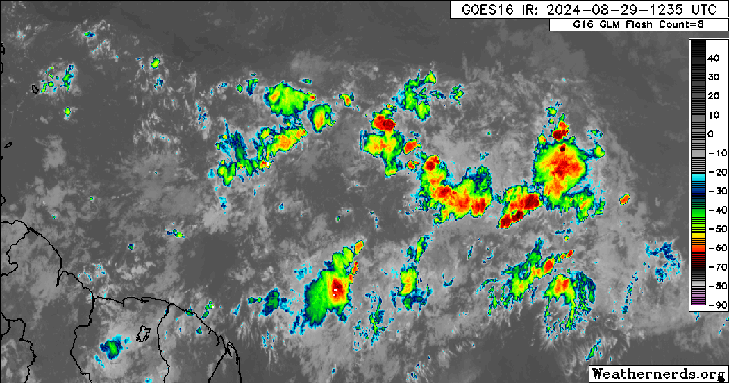
Considering that it's been 5 hours since the initialization of 12z GFS, I took a look at the actual evolution of the system. The loop below seems to show some new convection popping up inbetween the two lobes: the -70C tower in the last 2-3 frames of the loop, located at 46W, is such an example. While the two lobes themselves seem to have maintained similar amounts of convection over the 5 hours, it does seem that the eastern lobe has denser and cooler towers.

Image

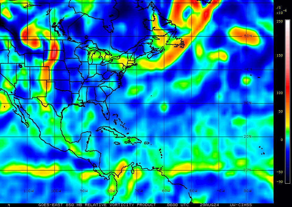
The trends in low-level vorticity from 6z to 15z also seem to show the western lobe extending (or even shifting) linearly to the east, although CIMSS's imagery seems to be at a lower resolution than GFS.

Image

Of course, all of this could have also suffered from confirmation bias, so please draw your own conclusions. It might also be too early to tell.
Last edited by Teban54 on Thu Aug 29, 2024 12:51 pm, edited 1 time in total.
1 likes   

otowntiger
Category 5
Category 5
Posts: 1921
Joined: Tue Aug 31, 2004 7:06 pm

Re: Tropical Wave in Central Atlantic (0/40)

#229 Postby otowntiger » Thu Aug 29, 2024 12:51 pm

Cpv17 wrote:
Ivanhater wrote:12Z GFS drops it :lol:


That’s actually bad because it could go further west then.
what could go further west?
0 likes   

User avatar
SFLcane
S2K Supporter
S2K Supporter
Posts: 10162
Age: 47
Joined: Sat Jun 05, 2010 1:44 pm
Location: Lake Worth Florida

Re: Tropical Wave in Central Atlantic (0/40)

#230 Postby SFLcane » Thu Aug 29, 2024 12:51 pm

Image
2 likes   

User avatar
toad strangler
S2K Supporter
S2K Supporter
Posts: 4543
Joined: Sun Jul 28, 2013 3:09 pm
Location: Earth
Contact:

Re: Tropical Wave in Central Atlantic (0/40)

#231 Postby toad strangler » Thu Aug 29, 2024 12:54 pm

12z Euro shows a TC just S of western Cuba heading NW at the end of the run @ 240
0 likes   

LarryWx
Category 5
Category 5
Posts: 6246
Joined: Sun Sep 07, 2003 2:04 pm
Location: GA

Re: Tropical Wave in Central Atlantic (0/40)

#232 Postby LarryWx » Thu Aug 29, 2024 12:57 pm


Is Mr. Slowsky in charge of the speed of the 12Z CMC today? It is taking forever everywhere.

12Z Euro 240: halfway between Grand Cayman and Isle of Youth at 1003 mb moving slowly NW
0 likes   
Personal Forecast Disclaimer:
The posts in this forum are NOT official forecasts and should not be used as such. They are just the opinion of the poster and may or may not be backed by sound meteorological data. They are NOT endorsed by any professional institution or storm2k.org. For official information, please refer to the NHC and NWS products.

User avatar
SFLcane
S2K Supporter
S2K Supporter
Posts: 10162
Age: 47
Joined: Sat Jun 05, 2010 1:44 pm
Location: Lake Worth Florida

Re: Tropical Wave in Central Atlantic (0/40)

#233 Postby SFLcane » Thu Aug 29, 2024 12:59 pm

LarryWx wrote:


Is Mr. Slowsky in charge of the speed of the 12Z CMC today? It is taking forever everywhere.

12Z Euro 240: halfway between Grand Cayman and Isle of Youth at 1003 mb moving slowly NW


fyi..dont by that euro one bit lol.
0 likes   

User avatar
toad strangler
S2K Supporter
S2K Supporter
Posts: 4543
Joined: Sun Jul 28, 2013 3:09 pm
Location: Earth
Contact:

Re: Tropical Wave in Central Atlantic (0/40)

#234 Postby toad strangler » Thu Aug 29, 2024 12:59 pm

LarryWx wrote:


Is Mr. Slowsky in charge of the speed of the 12Z CMC today? It is taking forever everywhere.

12Z Euro 240: halfway between Grand Cayman and Isle of Youth at 1003 mb moving slowly NW


CMC ended with a TC just a hair S of Central Cuba moving slowly NW
0 likes   

User avatar
SFLcane
S2K Supporter
S2K Supporter
Posts: 10162
Age: 47
Joined: Sat Jun 05, 2010 1:44 pm
Location: Lake Worth Florida

Re: Tropical Wave in Central Atlantic (0/40)

#235 Postby SFLcane » Thu Aug 29, 2024 1:01 pm

toad strangler wrote:
LarryWx wrote:


Is Mr. Slowsky in charge of the speed of the 12Z CMC today? It is taking forever everywhere.

12Z Euro 240: halfway between Grand Cayman and Isle of Youth at 1003 mb moving slowly NW


CMC ended with a TC just a hair S of Central Cuba


Ended? Slowsky took over its stuck in 210 hrs.
0 likes   

User avatar
toad strangler
S2K Supporter
S2K Supporter
Posts: 4543
Joined: Sun Jul 28, 2013 3:09 pm
Location: Earth
Contact:

Re: Tropical Wave in Central Atlantic (0/40)

#236 Postby toad strangler » Thu Aug 29, 2024 1:03 pm

SFLcane wrote:
toad strangler wrote:
LarryWx wrote:
Is Mr. Slowsky in charge of the speed of the 12Z CMC today? It is taking forever everywhere.

12Z Euro 240: halfway between Grand Cayman and Isle of Youth at 1003 mb moving slowly NW


CMC ended with a TC just a hair S of Central Cuba


Ended? Slowsky took over its stuck in 210 hrs.


MY BAD Adrian! Yes it's stuck at 210.
1 likes   

User avatar
Ivanhater
Storm2k Moderator
Storm2k Moderator
Posts: 11153
Age: 38
Joined: Fri Jul 01, 2005 8:25 am
Location: Pensacola

Re: Tropical Wave in Central Atlantic (0/40)

#237 Postby Ivanhater » Thu Aug 29, 2024 1:16 pm

Looks like heights are building back with the trough on the way out on Canadian...not good :eek:
0 likes   
Michael

AutoPenalti
Category 5
Category 5
Posts: 4029
Age: 28
Joined: Mon Aug 17, 2015 4:16 pm
Location: Ft. Lauderdale, Florida

Re: Tropical Wave in Central Atlantic (0/40)

#238 Postby AutoPenalti » Thu Aug 29, 2024 1:17 pm

toad strangler wrote:
SFLcane wrote:
toad strangler wrote:
CMC ended with a TC just a hair S of Central Cuba


Ended? Slowsky took over its stuck in 210 hrs.


MY BAD Adrian! Yes it's stuck at 210.

If you extrap that compared to 0z, that has to be a big bend run?
0 likes   
The posts in this forum are NOT official forecasts and should not be used as such. They are just the opinion of the poster and may or may not be backed by sound meteorological data. They are NOT endorsed by any professional institution or STORM2K. For official information, please refer to products from the NHC and NWS.


Model Runs Cheat Sheet:
GFS (5:30 AM/PM, 11:30 AM/PM)
HWRF, GFDL, UKMET, NAVGEM (6:30-8:00 AM/PM, 12:30-2:00 AM/PM)
ECMWF (1:45 AM/PM)

TCVN
is a weighted averaged

LarryWx
Category 5
Category 5
Posts: 6246
Joined: Sun Sep 07, 2003 2:04 pm
Location: GA

Re: Tropical Wave in Central Atlantic (0/40)

#239 Postby LarryWx » Thu Aug 29, 2024 1:20 pm

Well, I know Adrian isn’t currently nightnight unfortunately. Not good on the 12Z Euro ens as it is active again with many near FL. :eek:
Can we cancel this run?
Last edited by LarryWx on Thu Aug 29, 2024 1:22 pm, edited 1 time in total.
0 likes   
Personal Forecast Disclaimer:
The posts in this forum are NOT official forecasts and should not be used as such. They are just the opinion of the poster and may or may not be backed by sound meteorological data. They are NOT endorsed by any professional institution or storm2k.org. For official information, please refer to the NHC and NWS products.

Stratton23
Category 5
Category 5
Posts: 2370
Joined: Fri Jul 21, 2023 10:59 pm
Location: Katy, Tx

Re: Tropical Wave in Central Atlantic (0/40)

#240 Postby Stratton23 » Thu Aug 29, 2024 1:21 pm

Big yikes for the whole entire gulf and se us on the 12z EPS!
2 likes   


Return to “Talkin' Tropics”

Who is online

Users browsing this forum: No registered users and 151 guests