
ENSO Updates (2007 thru 2023)
Moderator: S2k Moderators
Forum rules

The posts in this forum are NOT official forecasts and should not be used as such. They are just the opinion of the poster and may or may not be backed by sound meteorological data. They are NOT endorsed by any professional institution or STORM2K. For official information, please refer to products from the National Hurricane Center and National Weather Service.
-
cycloneye

- Admin

- Posts: 149475
- Age: 69
- Joined: Thu Oct 10, 2002 10:54 am
- Location: San Juan, Puerto Rico
Re: CPC Update/Nino 3.4 reaches El Nino threshold/up to +0.6C
The 30 day SOI has continued to be below -8 for almost two weeks . Is at this time at -11.8. Sustained value of -8 means El Nino is comming very soon.
0 likes
Visit the Caribbean-Central America Weather Thread where you can find at first post web cams,radars
and observations from Caribbean basin members Click Here
and observations from Caribbean basin members Click Here
-
dexterlabio
- Category 5

- Posts: 3507
- Joined: Sat Oct 24, 2009 11:50 pm
Re: CPC Update/Nino 3.4 reaches El Nino threshold/up to +0.6C
with these developments, i think it is very safe to say that El Nino will officially kick in by August and start affecting the atmospheric conditions probably by September.
The posts in this forum are NOT official forecast and should not be used as such. They are just the opinion of the poster and may or may not be backed by sound meteorological data.
The posts in this forum are NOT official forecast and should not be used as such. They are just the opinion of the poster and may or may not be backed by sound meteorological data.
0 likes
Personal Forecast Disclaimer:
The posts in this forum are NOT official forecast and should not be used as such. They are just the opinion of the poster and may or may not be backed by sound meteorological data. They are NOT endorsed by any professional institution or storm2k.org. For official information, please refer to the NHC and NWS products.
The posts in this forum are NOT official forecast and should not be used as such. They are just the opinion of the poster and may or may not be backed by sound meteorological data. They are NOT endorsed by any professional institution or storm2k.org. For official information, please refer to the NHC and NWS products.

Re: CPC Update/Nino 3.4 reaches El Nino threshold/up to +0.6C
Kingarabian wrote:hcane27 wrote:Blown Away wrote:Does this years pattern resemble an El Nino year of the past?
Currently the pattern from January thru May in Nino 3-4 most closely resembles 1951 , 2006 , and 2009
Not so sure about 2009.
2009's El-Nino was really strong and it suppressed all activity in the Atlantic basin.
It matches in "pattern" , that means both years began at slightly below -1.0 and they both have rising values through May. Yes , 2009 was warmer by May , .18 compared to -.05 this year , but I was making the observation that the years that "best" matched from January to May were those mentioned. Patterns and values within a range , not absolutes. And all three years continued to rise except 2006, which dipped in July from .20 to .13 , then rising again. By November they were all from .87 (1951) to 1.54 (2009). We shall see what happens , and one factor will not have a complete answer , but it is my guess that if the pattern follows , then the Atlantic season will end up somewhere near 11 in named storms. Not a forecast of any kind , just a guess.
0 likes
-
cycloneye
- Admin
- Posts: 149475
- Age: 69
- Joined: Thu Oct 10, 2002 10:54 am
- Location: San Juan, Puerto Rico
Re: CPC Update/Nino 3.4 reaches El Nino threshold/up to +0.6C
Australian ENSO Update of 7/3/12
No surprises here.
Increasing risk of El Niño in 2012
Issued on Tuesday 3 July | Product Code IDCKGEWWOO
Climate indicators continue to show a shift towards El Niño, in line with most model predictions. Eastern and central tropical Pacific Ocean temperatures have continued to warm over the past fortnight, while trade winds have remained weaker than normal. Likewise, the Southern Oscillation Index (SOI) has become more strongly negative over the past month.
Tropical Pacific Ocean observations are consistent with previous and current climate model forecasts, which have indicated that the tropical Pacific may approach or exceed El Niño thresholds sometime between mid-winter and spring 2012.
During El Niño events, large parts of eastern Australia are typically drier than normal during winter and spring, while southern Australian daytime temperatures tend to be warmer. However, El Niño does not guarantee widespread dry conditions.
http://www.bom.gov.au/climate/enso/
0 likes
Visit the Caribbean-Central America Weather Thread where you can find at first post web cams,radars
and observations from Caribbean basin members Click Here
and observations from Caribbean basin members Click Here


-
cycloneye
- Admin
- Posts: 149475
- Age: 69
- Joined: Thu Oct 10, 2002 10:54 am
- Location: San Juan, Puerto Rico
Re: Breaking News=Chances increase for El Niño beginning in JAS
Climate Prediction Center July Update at 7/5/12
Here comes El Nino.
Synopsis: Chances increase for El Niño beginning in July-September 2012.
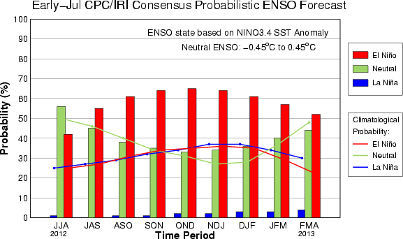
During June 2012, ENSO-neutral continued as reflected in both the oceanic and atmospheric anomalies. However, positive equatorial Pacific sea surface temperature (SST) anomalies have grown, exceeding +0.5oC across the eastern Pacific Ocean by the end of June (Fig. 1). SST anomalies increase moving from the westernmost Niño 4 region to the Niño 1+2 region adjacent to South America, which remained near +1.5oC during the month (Fig. 2). The oceanic heat content anomalies (average temperature in the upper 300m of the ocean) increased during June (Fig. 3), as above-average sub-surface temperatures became more entrenched in the equatorial Pacific (Fig. 4). This warming was consistent with a weakening of the low-level trade winds across the east-central equatorial Pacific, along with a weakening of the persistent pattern of enhanced convection near Papua New Guinea (Fig. 5). The observations are consistent with ENSO-neutral, but reflect a likely progression towards El Niño.
There continues to be a substantial disparity between the statistical and dynamical model SST forecasts for the Niño-3.4 region (Fig. 6). The dynamical models, including the NCEP Climate Forecast System (CFS), largely favor the development of El Niño by July-September 2012, while the majority of statistical models predict ENSO-neutral through the rest of 2012. The forecaster consensus largely favors the dynamical model outcome because those models tend to exhibit greater skill emerging from the Northern Hemisphere "spring barrier" (a period of relatively low confidence ENSO forecasts) and also due to the strengthening of observed signals indicating an evolution towards El Niño. Overall, the forecaster consensus reflects increased chances for El Niño beginning in July-September 2012 (see CPC/IRI consensus forecast).
http://www.cpc.ncep.noaa.gov/products/a ... odisc.html
Here comes El Nino.
Synopsis: Chances increase for El Niño beginning in July-September 2012.
During June 2012, ENSO-neutral continued as reflected in both the oceanic and atmospheric anomalies. However, positive equatorial Pacific sea surface temperature (SST) anomalies have grown, exceeding +0.5oC across the eastern Pacific Ocean by the end of June (Fig. 1). SST anomalies increase moving from the westernmost Niño 4 region to the Niño 1+2 region adjacent to South America, which remained near +1.5oC during the month (Fig. 2). The oceanic heat content anomalies (average temperature in the upper 300m of the ocean) increased during June (Fig. 3), as above-average sub-surface temperatures became more entrenched in the equatorial Pacific (Fig. 4). This warming was consistent with a weakening of the low-level trade winds across the east-central equatorial Pacific, along with a weakening of the persistent pattern of enhanced convection near Papua New Guinea (Fig. 5). The observations are consistent with ENSO-neutral, but reflect a likely progression towards El Niño.
There continues to be a substantial disparity between the statistical and dynamical model SST forecasts for the Niño-3.4 region (Fig. 6). The dynamical models, including the NCEP Climate Forecast System (CFS), largely favor the development of El Niño by July-September 2012, while the majority of statistical models predict ENSO-neutral through the rest of 2012. The forecaster consensus largely favors the dynamical model outcome because those models tend to exhibit greater skill emerging from the Northern Hemisphere "spring barrier" (a period of relatively low confidence ENSO forecasts) and also due to the strengthening of observed signals indicating an evolution towards El Niño. Overall, the forecaster consensus reflects increased chances for El Niño beginning in July-September 2012 (see CPC/IRI consensus forecast).
http://www.cpc.ncep.noaa.gov/products/a ... odisc.html
0 likes
Visit the Caribbean-Central America Weather Thread where you can find at first post web cams,radars
and observations from Caribbean basin members Click Here
and observations from Caribbean basin members Click Here
-
cycloneye
- Admin
- Posts: 149475
- Age: 69
- Joined: Thu Oct 10, 2002 10:54 am
- Location: San Juan, Puerto Rico
Re: CPC 7/5/12: Chances increase for El Niño beginning in JAS
Here is the discussion about this update by CPC by Dr Jeff Masters:
The odds of an El Niño event developing in time for the August - September - October peak of hurricane season have grown to 61%, said NOAA's Climate Prediction Center in their latest El Niño/Southern Oscillation (ENSO) diagnostic discussion, released on July 5. Ocean temperatures in the equatorial Pacific have increased to 0.6°C above average this week, which is just above the 0.5°C above-average threshold used to define a weak El Niño event. These temperatures must remain 0.5° or more above average for three consecutive months to qualify as an official El Niño. CPC advised that current conditions show a weakening of the east-to-west trade winds over the east-central equatorial Pacific, along with a reduction in heavy thunderstorm activity over Papua New Guinea, which "reflect a likely progression towards El Niño." However, the upper atmospheric winds and circulation patterns don't resemble what we expect of an El Niño yet. For example, in June over the North Pacific Ocean, there was an overall ridge of high pressure (more characteristic of La Niña) rather than a trough of low pressure (more typical during an El Niño). Thus, any development of El Niño during July is likely to be slow. El Niño events tend to suppress Atlantic hurricane activity by increasing the upper-level winds that create high wind shear capable of tearing storms apart
The odds of an El Niño event developing in time for the August - September - October peak of hurricane season have grown to 61%, said NOAA's Climate Prediction Center in their latest El Niño/Southern Oscillation (ENSO) diagnostic discussion, released on July 5. Ocean temperatures in the equatorial Pacific have increased to 0.6°C above average this week, which is just above the 0.5°C above-average threshold used to define a weak El Niño event. These temperatures must remain 0.5° or more above average for three consecutive months to qualify as an official El Niño. CPC advised that current conditions show a weakening of the east-to-west trade winds over the east-central equatorial Pacific, along with a reduction in heavy thunderstorm activity over Papua New Guinea, which "reflect a likely progression towards El Niño." However, the upper atmospheric winds and circulation patterns don't resemble what we expect of an El Niño yet. For example, in June over the North Pacific Ocean, there was an overall ridge of high pressure (more characteristic of La Niña) rather than a trough of low pressure (more typical during an El Niño). Thus, any development of El Niño during July is likely to be slow. El Niño events tend to suppress Atlantic hurricane activity by increasing the upper-level winds that create high wind shear capable of tearing storms apart
0 likes
Visit the Caribbean-Central America Weather Thread where you can find at first post web cams,radars
and observations from Caribbean basin members Click Here
and observations from Caribbean basin members Click Here
-
hurricanetrack

- HurricaneTrack.com
- Posts: 1781
- Joined: Tue Dec 02, 2003 10:46 pm
- Location: Wilmington, NC
- Contact:
The way it looks now, the Nino would be eastern Pacific weighted and not very strong anyway. Time is running out for a big time El Nino that would all but kill off the Atlantic season. It is, after all, July now and not April or May. We enter the peak months in about 60 days. Interesting times ahead to be sure....
0 likes
-
Blown Away

- S2K Supporter

- Posts: 10253
- Joined: Wed May 26, 2004 6:17 am
Re: CPC 7/5/12: Chances increase for El Niño beginning in JAS
How does this year compare to an El Nino year like 2004, where we saw a busy hurricane season?
0 likes
Hurricane Eye Experience: David 79, Irene 99, Frances 04, Jeanne 04, Wilma 05… Hurricane Brush Experience: Andrew 92, Erin 95, Floyd 99, Matthew 16, Irma 17, Ian 22, Nicole 22…
Re: CPC 7/5/12: Chances increase for El Niño beginning in JAS
Blown Away wrote:How does this year compare to an El Nino year like 2004, where we saw a busy hurricane season?
In 2004 all regions ( 1+2 , 3 , 4 , 3+4 ) started the year much warmer. But none ever reached + 1.0 C above "normal" for the year.
So far 1+2 is already at + 1.59 in 2004 was at - 1.22.
Nino 3 is at + .66 and in 2004 was only at + .16.
Nino 4 is at - .11 and was at .33 in 2004.
Nino 3+4 was at + .11 and is now at + .31.
All the regions have been warming , whereas in 2004 they were declining until April or May. It appears as though this year may indeed be east-based whereas 2004 was more central-based.
0 likes

Re: CPC 7/5/12: Chances increase for El Niño beginning in JAS
hcane27 wrote:Blown Away wrote:How does this year compare to an El Nino year like 2004, where we saw a busy hurricane season?
In 2004 all regions ( 1+2 , 3 , 4 , 3+4 ) started the year much warmer. But none ever reached + 1.0 C above "normal" for the year.
So far 1+2 is already at + 1.59 in 2004 was at - 1.22.
Nino 3 is at + .66 and in 2004 was only at + .16.
Nino 4 is at - .11 and was at .33 in 2004.
Nino 3+4 was at + .11 and is now at + .31.
All the regions have been warming , whereas in 2004 they were declining until April or May. It appears as though this year may indeed be east-based whereas 2004 was more central-based.
2004 was a Modoki El Nino, which is in Central Pacific.
0 likes


Since 2004 was brought up here is a comparison of SST anomalies.
Most Recent

2004 roughly the same time July 3rd

2004 indeed was a Modoki Nino as said by Ptarmigan which favors Atlantic storm formation. During a Modoki Nino ENSO regions 1+2 remain cold and unaffected by warming. 2012 is more traditional where it starts east and spreads west.
Most Recent
2004 roughly the same time July 3rd
2004 indeed was a Modoki Nino as said by Ptarmigan which favors Atlantic storm formation. During a Modoki Nino ENSO regions 1+2 remain cold and unaffected by warming. 2012 is more traditional where it starts east and spreads west.
0 likes
The above post and any post by Ntxw is NOT an official forecast and should not be used as such. It is just the opinion of the poster and may or may not be backed by sound meteorological data. It is NOT endorsed by any professional institution including Storm2k. For official information, please refer to NWS products.
Help support Storm2K!
Re: CPC 7/5/12: Chances increase for El Niño beginning in JAS
Two Types of El Nino Events: Cold Tongue El Nino and Warm Pool El Nino
http://journals.ametsoc.org/doi/pdf/10. ... JCLI2624.1
There are different kinds of El Ninos/La Ninas. They are not all the same.
http://journals.ametsoc.org/doi/pdf/10. ... JCLI2624.1
There are different kinds of El Ninos/La Ninas. They are not all the same.
0 likes
-
cycloneye
- Admin
- Posts: 149475
- Age: 69
- Joined: Thu Oct 10, 2002 10:54 am
- Location: San Juan, Puerto Rico
Re: ENSO: CPC 7/9/12 Update: Nino 3.4 cooled slightly
Climate Prediction Center 7/9/12 Weekly Update
In fact,all Nino regions cooled a tad when you look at the numbers and graphics. It will be interesting to see if this is only a temporary trend or warming will start again in the next couple of weeks.
http://www.cpc.ncep.noaa.gov/products/a ... ts-web.pdf

In fact,all Nino regions cooled a tad when you look at the numbers and graphics. It will be interesting to see if this is only a temporary trend or warming will start again in the next couple of weeks.
http://www.cpc.ncep.noaa.gov/products/a ... ts-web.pdf
0 likes
Visit the Caribbean-Central America Weather Thread where you can find at first post web cams,radars
and observations from Caribbean basin members Click Here
and observations from Caribbean basin members Click Here

Re: ENSO: CPC 7/9/12 Update: Nino 3.4 cooled slightly
cycloneye wrote:Climate Prediction Center 7/9/12 Weekly Update
In fact,all Nino regions cooled a tad when you look at the numbers and graphics. It will be interesting to see if this is only a temporary trend or warming will start again in the next couple of weeks.
El Nino cancel.
0 likes
MJO is currently sitting over the Indian Ocean. Until it's return to the Pacific, significant warming is unlikely and was the case in today's update. Two steps forward one step back kind of thing. Different models portray diff scenarios. Euro wants to keep the MJO around the Indian Ocean while Uk and GFS returns it to the western hemisphere.

0 likes
The above post and any post by Ntxw is NOT an official forecast and should not be used as such. It is just the opinion of the poster and may or may not be backed by sound meteorological data. It is NOT endorsed by any professional institution including Storm2k. For official information, please refer to NWS products.
Help support Storm2K!
Help support Storm2K!
-
TropicalAnalystwx13

- Category 5
- Posts: 2109
- Age: 28
- Joined: Tue Jul 19, 2011 8:20 pm
- Location: Wilmington, NC
- Contact:
-
cycloneye
- Admin
- Posts: 149475
- Age: 69
- Joined: Thu Oct 10, 2002 10:54 am
- Location: San Juan, Puerto Rico
Re: CPC 7/9/12 Update: Nino 3.4 cooled slightly (+0.6C to +0.5C)
The warming trend that was going on and was announcing with fanfare El Nino comming very soon has leveled off at least for this week as the CPC update shows. Waiting for another kelvin wave to push it officially it seems as our friend Ntxw said.

0 likes
Visit the Caribbean-Central America Weather Thread where you can find at first post web cams,radars
and observations from Caribbean basin members Click Here
and observations from Caribbean basin members Click Here
Re:
TropicalAnalystwx13 wrote:What does the MJO have to do with El Niño/La Niña?
Active MJO activity promotes convection and that brings westerlies over the pacific. Westerlies warm while a lack of MJO activity promotes easterly trades which cool. A persistent Kelvin wave is evident in El Nino's (aka subtropical jet) in the central pacific. Once that is established you know well that El Nino has a hold of the atmosphere.
0 likes
The above post and any post by Ntxw is NOT an official forecast and should not be used as such. It is just the opinion of the poster and may or may not be backed by sound meteorological data. It is NOT endorsed by any professional institution including Storm2k. For official information, please refer to NWS products.
Help support Storm2K!
Help support Storm2K!
Who is online
Users browsing this forum: Google [Bot], Sciencerocks, TeamPlayersBlue and 188 guests