
2020 Global Model Runs Discussion (Out thru day 16)
Moderator: S2k Moderators
Forum rules

The posts in this forum are NOT official forecasts and should not be used as such. They are just the opinion of the poster and may or may not be backed by sound meteorological data. They are NOT endorsed by any professional institution or STORM2K. For official information, please refer to products from the National Hurricane Center and National Weather Service.
-
SFLcane

- S2K Supporter

- Posts: 10281
- Age: 48
- Joined: Sat Jun 05, 2010 1:44 pm
- Location: Lake Worth Florida
Re: 2020 Global Model Runs Discussion (Out thru day 16)
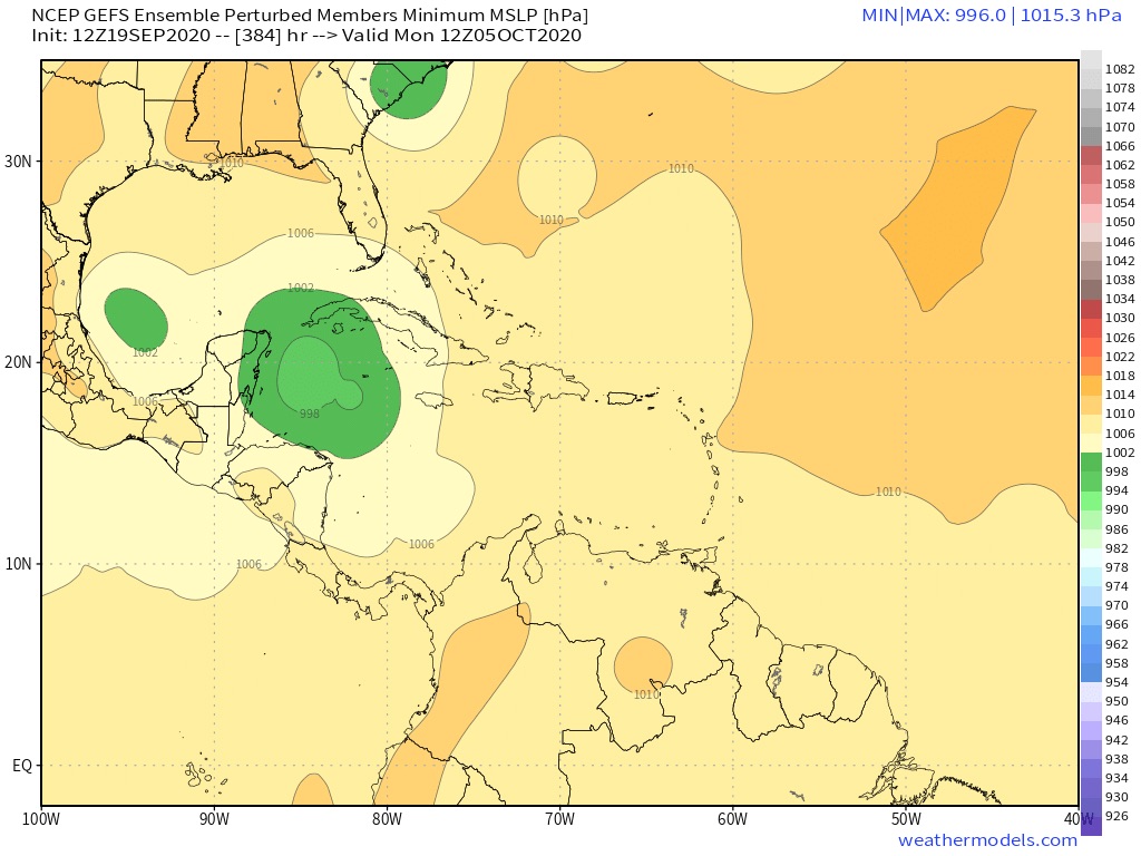
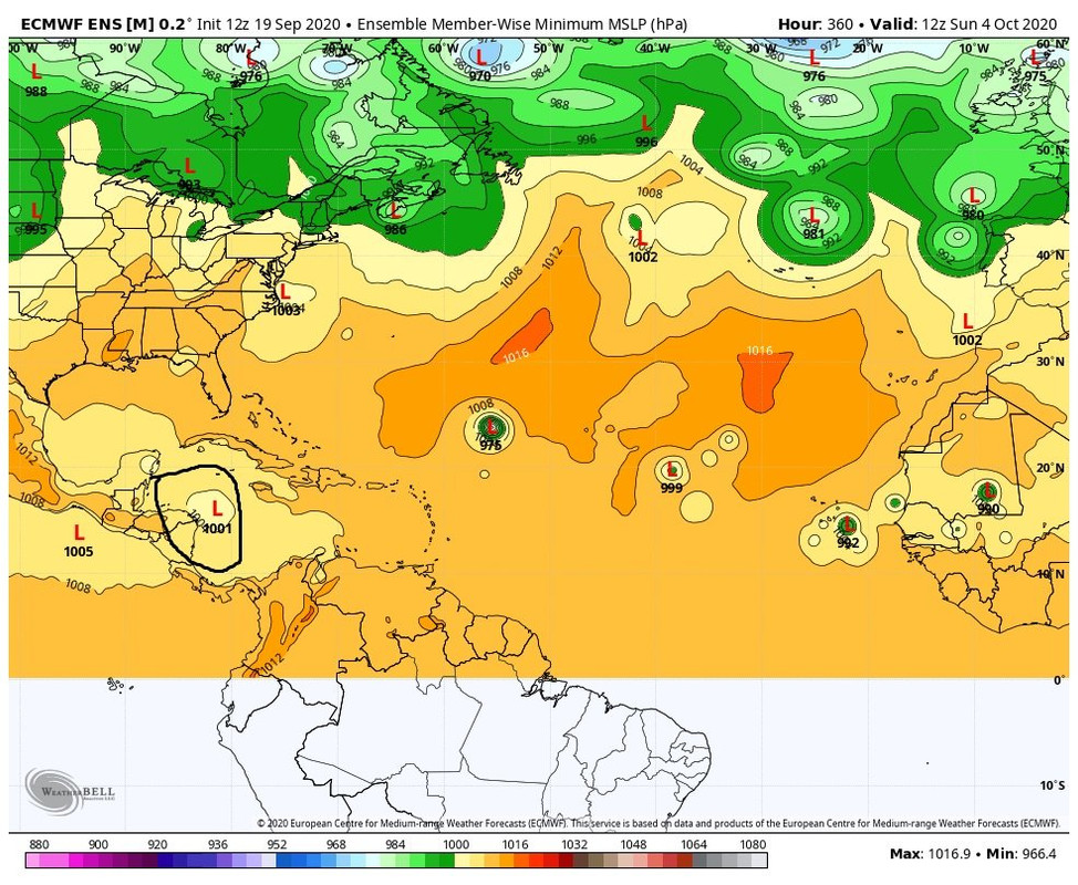
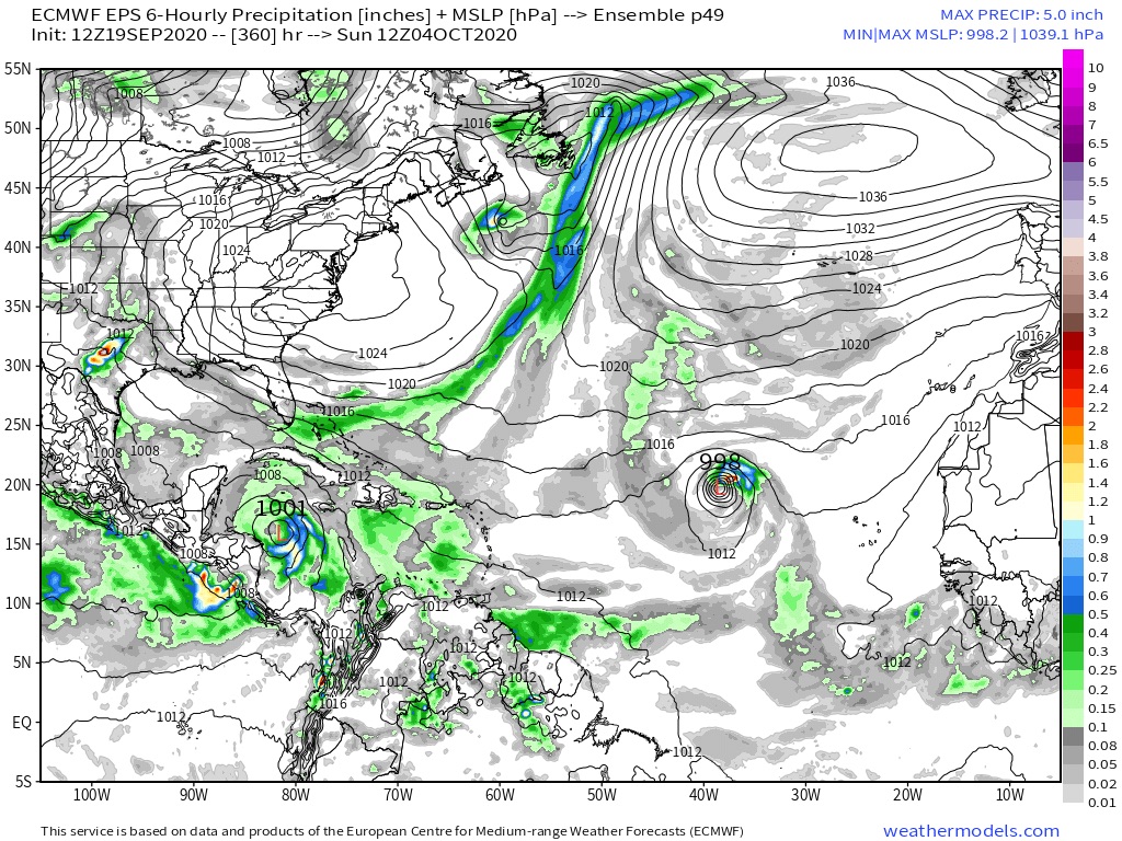
We can always do some model eye candy.. 

6 likes
-
NevadaFan18
- Tropical Depression

- Posts: 51
- Joined: Fri Aug 21, 2020 1:51 pm
Re: 2020 Global Model Runs Discussion (Out thru day 16)
aspen wrote:The CFS has also shown a Caribbean system like that, and the CFS has done well sniffing out systems like Isaias weeks in advance. I guess we better start preparing ourselves for Cat 5 Hurricane Delta or something like that.
There's also a great thread on Twitter detailing how the WCAB could feature some activity as we get into October
https://twitter.com/TheSteveCop/status/ ... 28900?s=20
0 likes
-
HURRICANELONNY
- Category 5

- Posts: 1392
- Joined: Wed May 07, 2003 6:48 am
- Location: HOLLYWOOD.FL
Re: 2020 Global Model Runs Discussion (Out thru day 16)
One of these times the GFS is gonna be right this far out and nobody gonna believe it including me. Get Florida Soon= GFS 
4 likes
hurricanelonny

Re: 2020 Global Model Runs Discussion (Out thru day 16)
WeatherEmperor wrote:There is your South Florida hurricane. ROFL!!
https://uploads.tapatalk-cdn.com/20200918/894881983571b1ab42d395b826e0fd39.jpg
Sent from my iPhone using Tapatalk
It needs to be a category five so I can check it off my 2020 bingo card. Technically it doesn't have to be a category five at landfall.
2 likes
-
CourierPR

- Category 5
- Posts: 1336
- Age: 72
- Joined: Tue Aug 31, 2004 7:53 pm
- Location: Pompano Beach, Florida
Re: 2020 Global Model Runs Discussion (Out thru day 16)
HURRICANELONNY wrote:One of these times the GFS is gonna be right this far out and nobody gonna believe it including me. Get Florida Soon= GFS
If I see a tweet by Met. Joe Bastardi calling for Caribbean development, then I will take notice. He is very adept at pattern recognition regarding cyclogenesis.
0 likes
-
SootyTern
- S2K Supporter
- Posts: 316
- Age: 57
- Joined: Sun Sep 05, 2004 5:09 pm
- Location: NYC (formerly Homestead, FL)
Re: 2020 Global Model Runs Discussion (Out thru day 16)
Looks like backside. Will probably be blowing 15 to 20 with partly cloudy skies at my house. Will feel like an idiot for putting up the shutters and pulling all the orchids inside
1 likes
Disclaimer:
The posts in this forum are NOT official forecasts and should not be used as such. For official information, please refer to the NHC and NWS products.
Gulf Coast: Opal '95 Georges '98 / So Fla: Katrina '05 Wilma '05 Irma '17
The posts in this forum are NOT official forecasts and should not be used as such. For official information, please refer to the NHC and NWS products.
Gulf Coast: Opal '95 Georges '98 / So Fla: Katrina '05 Wilma '05 Irma '17
-
SFLcane
- S2K Supporter
- Posts: 10281
- Age: 48
- Joined: Sat Jun 05, 2010 1:44 pm
- Location: Lake Worth Florida
Re: 2020 Global Model Runs Discussion (Out thru day 16)
SootyTern wrote:
Looks like backside. Will probably be blowing 15 to 20 with partly cloudy skies at my house. Will feel like an idiot for putting up the shutters and pulling all the orchids inside
Backside? Um nope... How about the northern quadrant of a potential major cane if your in dade and Broward. Obviously for now this is fantasy range
0 likes
-
SootyTern
- S2K Supporter
- Posts: 316
- Age: 57
- Joined: Sun Sep 05, 2004 5:09 pm
- Location: NYC (formerly Homestead, FL)
Re: 2020 Global Model Runs Discussion (Out thru day 16)
SFLcane wrote:SootyTern wrote:
Looks like backside. Will probably be blowing 15 to 20 with partly cloudy skies at my house. Will feel like an idiot for putting up the shutters and pulling all the orchids inside
Backside? Um nope... How about the northern quadrant of a potential major cane if your in dade and Broward. Obviously for now this is fantasy range
I was joking. Because I can, because it is fantasy range
0 likes
Disclaimer:
The posts in this forum are NOT official forecasts and should not be used as such. For official information, please refer to the NHC and NWS products.
Gulf Coast: Opal '95 Georges '98 / So Fla: Katrina '05 Wilma '05 Irma '17
The posts in this forum are NOT official forecasts and should not be used as such. For official information, please refer to the NHC and NWS products.
Gulf Coast: Opal '95 Georges '98 / So Fla: Katrina '05 Wilma '05 Irma '17
-
TheStormExpert
Re: 2020 Global Model Runs Discussion (Out thru day 16)
18z GFS drops the long-range Florida hurricane but has a Central American Gyre developing in the first few days of October.
1 likes
-
MarioProtVI
- Category 5
- Posts: 1034
- Age: 24
- Joined: Sun Sep 29, 2019 7:33 pm
- Location: New Jersey
Re: 2020 Global Model Runs Discussion (Out thru day 16)
TheStormExpert wrote:18z GFS drops the long-range Florida hurricane but has a Central American Gyre developing in the first few days of October.
Signs that early October could be trouble...
1 likes

-
TheStormExpert
Re: 2020 Global Model Runs Discussion (Out thru day 16)
If anything were to develop in the next 1-2 weeks down in the Western Caribbean it would likely be drawn north as the NAO will be going negative.
0 likes
-
SETXstorms
Re: 2020 Global Model Runs Discussion (Out thru day 16)

might have us an october storm a-brewing
0 likes
-
DestinHurricane

- Category 4

- Posts: 935
- Joined: Tue May 01, 2018 8:05 am
- Location: New York, NY
Re: 2020 Global Model Runs Discussion (Out thru day 16)
TheStormExpert wrote:If anything were to develop in the next 1-2 weeks down in the Western Caribbean it would likely be drawn north as the NAO will be going negative.
Due north or northeast or would either be possible?
0 likes
Michael 2018

Re: 2020 Global Model Runs Discussion (Out thru day 16)
The CMC has sniffed out the next wave to watch. Another low-latitude AEW is set to emerge off of Africa on Monday the 21st and track just about due west, reaching the Lesser Antilles on Sunday the 27th. This might be the wave that spawns the Caribbean hurricane the GFS was showing for a while.
0 likes
Irene '11 Sandy '12 Hermine '16 5/15/2018 Derecho Fay '20 Isaias '20 Elsa '21 Henri '21 Ida '21
I am only a meteorology enthusiast who knows a decent amount about tropical cyclones. Look to the professional mets, the NHC, or your local weather office for the best information.
I am only a meteorology enthusiast who knows a decent amount about tropical cyclones. Look to the professional mets, the NHC, or your local weather office for the best information.

Re: 2020 Global Model Runs Discussion (Out thru day 16)
What are the potential of systems inside the Caribbean?
0 likes
Personal Forecast Disclaimer:
The posts in this forum are NOT official forecast and should not be used as such. They are just the opinion of the poster and may or may not be backed by sound meteorological data. They are NOT endorsed by any professional institution or storm2k.org. For official information, please refer to the NHC and NWS products.
The posts in this forum are NOT official forecast and should not be used as such. They are just the opinion of the poster and may or may not be backed by sound meteorological data. They are NOT endorsed by any professional institution or storm2k.org. For official information, please refer to the NHC and NWS products.
-
otowntiger
- Category 5
- Posts: 1932
- Joined: Tue Aug 31, 2004 7:06 pm
Re: 2020 Global Model Runs Discussion (Out thru day 16)
SFLcane wrote:Some ensembles extreme long range.
https://i.postimg.cc/D0CYv2y3/CB0-F2-F6-F-82-D6-483-F-9-F10-AC1-A6486-B593.jpg
https://i.postimg.cc/zfm2X25v/2-A4-BC2-E0-75-ED-4-FF5-9-FBC-924-B591-A5733.jpg
Interesting to note, to me it looks like the synoptic set up in both images would push those systems into Mexico, right? Of course I realize this is well into fantasy land but that’s very opposed to climatology for that area, that time of year. Isn’t the predominant trough pattern usually pulling storms out of the NW Caribbean ENE?
0 likes
Re: 2020 Global Model Runs Discussion (Out thru day 16)
otowntiger wrote:SFLcane wrote:Some ensembles extreme long range.
https://i.postimg.cc/D0CYv2y3/CB0-F2-F6-F-82-D6-483-F-9-F10-AC1-A6486-B593.jpg
https://i.postimg.cc/zfm2X25v/2-A4-BC2-E0-75-ED-4-FF5-9-FBC-924-B591-A5733.jpg
Interesting to note, to me it looks like the synoptic set up in both images would push those systems into Mexico, right? Of course I realize this is well into fantasy land but that’s very opposed to climatology for that area, that time of year. Isn’t the predominant trough pattern usually pulling storms out of the NW Caribbean ENE?
Not necessarily. there are plenty of late season storms that move into central america. Recall Mitch 1998 actually dropped south in October of that year. We are probably going to have some storms...perhaps significant come from this area. A north and northeast trajectory (eventually) is favored...it even happened with Mitch's remnants..but central america/Mexico remain very much at risk. The models starting to ping development should come as no shock considering the calendar and season to date thus far. stuff is going to happen but specifics are a long way off..
1 likes
Who is online
Users browsing this forum: Hammy and 166 guests