2021 Indicators: SST's / SAL / MSLP / Shear / Steering / Instability / Sat Images

This is the general tropical discussion area. Anyone can take their shot at predicting a storms path.

Moderator: S2k Moderators

Forum rules

The posts in this forum are NOT official forecasts and should not be used as such. They are just the opinion of the poster and may or may not be backed by sound meteorological data. They are NOT endorsed by any professional institution or STORM2K. For official information, please refer to products from the National Hurricane Center and National Weather Service.

Help Support Storm2K
Message
Author
User avatar
captainbarbossa19
Professional-Met
Professional-Met
Posts: 1092
Age: 27
Joined: Wed Aug 21, 2019 11:09 pm
Location: Beaumont, TX

Re: 2021 Indicators: SST's / SAL / MSLP / Shear / Steering / Instability / Sat Images

#2381 Postby captainbarbossa19 » Sun Aug 08, 2021 10:34 pm

tolakram wrote:I'll do what I did starting in 2017 and try and document the date and a brief synopsis of what is going on.

It's August 8th. 3 invests exist with 94L having what appears to be the best chance.

I grabbed a WV loop from 2017, that's a re-developing Harvey entering the Gulf. You can clearly see the TUTT here, the one Irma didn't have a problem with. You can also see all that horribly dry air in the Atlantic. This loop is 7 days before Irma formed.

https://i.imgur.com/W44nMso.gif

Here's today's WV loop. I can't find the same scale, if someone knows where to get the scale used in 2017 please let me know.
https://i.imgur.com/pmFDz83.gif


I am thinking that in 1-2 weeks, things are going to be different around here!
0 likes   

AxaltaRacing24
Category 5
Category 5
Posts: 1753
Age: 25
Joined: Wed Jul 27, 2016 11:14 am
Location: Jupiter, FL

Re: 2021 Indicators: SST's / SAL / MSLP / Shear / Steering / Instability / Sat Images

#2382 Postby AxaltaRacing24 » Sun Aug 08, 2021 10:43 pm

captainbarbossa19 wrote:
tolakram wrote:I'll do what I did starting in 2017 and try and document the date and a brief synopsis of what is going on.

It's August 8th. 3 invests exist with 94L having what appears to be the best chance.

I grabbed a WV loop from 2017, that's a re-developing Harvey entering the Gulf. You can clearly see the TUTT here, the one Irma didn't have a problem with. You can also see all that horribly dry air in the Atlantic. This loop is 7 days before Irma formed.

https://i.imgur.com/W44nMso.gif

Here's today's WV loop. I can't find the same scale, if someone knows where to get the scale used in 2017 please let me know.
https://i.imgur.com/pmFDz83.gif


I am thinking that in 1-2 weeks, things are going to be different around here!

For sure, there are some very favorable conditions that will be in place as climo ramps up. Yes this season didn't feature any July slop storms, but that has nothing to do with what the peak is about to look like.
3 likes   

User avatar
ElectricStorm
Category 5
Category 5
Posts: 5044
Age: 24
Joined: Tue Aug 13, 2019 11:23 pm
Location: Skiatook, OK / Norman, OK

Re: 2021 Indicators: SST's / SAL / MSLP / Shear / Steering / Instability / Sat Images

#2383 Postby ElectricStorm » Mon Aug 09, 2021 12:19 am

As mentioned before, the first half of August typically isn't all that active. Here the storms that developed from 8/1 to 8/15 over the past several years:
2020: TS Josephine 40kts, TS Kyle 45kts (Isaias was active in early Aug. but it formed in July)
2019: None
2018: TS Debby 45kts, TS Ernesto 40kts
2017: H Franklin 75 kts, H Gert 95kts
2016: H Earl 75kts
2015: None
2014: H Bertha 75kts
2013: TS Erin 40kts
2012: H Ernesto 85kts, TS Florence 50kts, TS Helene 40kts, H Gordon 95kts
2011: TS Emily 45kts, TS Franklin 40kts, TS Gert 55kts
2010: TS Colin 50kts, TD5 30 kts
2009: TS Ana 35kts, MH Bill 115kts
2008: TS Edouard 55kts, TS Fay 60kts
2007: MH Dean 150 kts (this one here is a major exception, becoming a Cat 5 mid-month), TS Erin 35kts
2006: TS Chris 55kts
2005: TS Harvey 55kts, H Irene 90kts, TD10 30kts
2004: Very active with multiple majors

There hasn't been a major hurricane that formed in this timeframe since Bill in 2009 (formed on 8/15) so it's been over a decade (although Gert in 2017 could have been). Also in the last decade, there's only been 3 storms to get stronger than a Cat 1 that formed in this timeframe. The only season on here that was really non-stop in early August was 2004. Other than that there hasn't been much before 8/20 besides Dean and Bill. I also find it interesting that 2004 is the only season on here that had a major in the first half of Aug, and then went on to have a very active season as a whole. 2007 and 2009, which had the other majors, weren't all that active, especially 09.

Peak season is almost here. A couple more weeks and it'll likely be off to the races.
8 likes   
B.S Meteorology, University of Oklahoma '25

Please refer to the NHC, NWS, or SPC for official information.

Shell Mound
Category 5
Category 5
Posts: 2434
Age: 32
Joined: Thu Sep 07, 2017 3:39 pm
Location: St. Petersburg, FL → Scandinavia

Re: 2021 Indicators: SST's / SAL / MSLP / Shear / Steering / Instability / Sat Images

#2384 Postby Shell Mound » Mon Aug 09, 2021 3:36 am

 https://twitter.com/jetsflyinghigh/status/1424453732566290442


A permanent “season cancel” for Southeast Florida: (in-)famous “last words”...? :eek: At least some people are already complacent, unfortunately.
0 likes   
CVW / MiamiensisWx / Shell Mound
The posts in this forum are NOT official forecasts and should not be used as such. They are just the opinion of the poster and may or may not be backed by sound meteorological data. They are NOT endorsed by any professional institution or STORM2K. For official information, please refer to products from the NHC and NWS.

AlphaToOmega
Category 5
Category 5
Posts: 1448
Joined: Sat Jun 26, 2021 10:51 am
Location: Somewhere in Massachusetts

Re: 2021 Indicators: SST's / SAL / MSLP / Shear / Steering / Instability / Sat Images

#2385 Postby AlphaToOmega » Mon Aug 09, 2021 6:18 am

Image
0 likes   

User avatar
Category5Kaiju
Category 5
Category 5
Posts: 4097
Joined: Thu Dec 24, 2020 12:45 pm
Location: Seattle

Re: 2021 Indicators: SST's / SAL / MSLP / Shear / Steering / Instability / Sat Images

#2386 Postby Category5Kaiju » Mon Aug 09, 2021 9:12 am

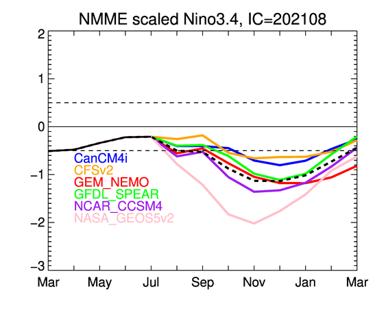
As of recently, in the EPAC, Kevin is now expected to remain a TS...when several days ago and in the ranged models even before that it was forecast to become a hurricane, with some models I remember taking it down even into the 940/950 mbar range. This is because of a very simple reason: unfavorable shear. With the ensemble models now hinting at an ever-increasingly active Atlantic, I think this is definitely a sign that the general principles of -ENSO/-PMM/-PDO disfavoring the EPAC while helping the Atlantic indirectly have not been broken and that even with an MJO-assisted boost, the EPAC is struggling to generate quality storms (which should be expected in August in a year expected to enter -ENSO territory). As I have mentioned before, we are still waiting for a second major hurricane in the basin, which judging based on many recent -ENSO years like 2010, 2011, 2012, 2016, and 2017, should have happened before August 9. Perhaps the next AOI could do that, but again, this year we have seen quite a few EPAC AOIs reach code red, only to not develop, and as with storms like Kevin and Hilda, contrary to initial predictions, underperform quite a bit due to dry air and shear.
1 likes   
Unless explicitly stated, all info in my posts is based on my own opinions and observations. Tropical storms and hurricanes can be extremely dangerous. Do not think you can beat Mother Nature. Refer to an accredited weather research agency or meteorologist if you need to make serious decisions regarding an approaching storm.

AlphaToOmega
Category 5
Category 5
Posts: 1448
Joined: Sat Jun 26, 2021 10:51 am
Location: Somewhere in Massachusetts

Re: 2021 Indicators: SST's / SAL / MSLP / Shear / Steering / Instability / Sat Images

#2387 Postby AlphaToOmega » Mon Aug 09, 2021 11:30 am

Image
5 likes   

User avatar
Cpv17
Category 5
Category 5
Posts: 4979
Joined: Wed Dec 07, 2016 2:24 pm
Location: Wharton/El Campo, TX

Re: 2021 Indicators: SST's / SAL / MSLP / Shear / Steering / Instability / Sat Images

#2388 Postby Cpv17 » Mon Aug 09, 2021 11:44 am

0 likes   

MarioProtVI
Category 4
Category 4
Posts: 935
Age: 24
Joined: Sun Sep 29, 2019 7:33 pm
Location: New Jersey

Re: 2021 Indicators: SST's / SAL / MSLP / Shear / Steering / Instability / Sat Images

#2389 Postby MarioProtVI » Mon Aug 09, 2021 11:47 am


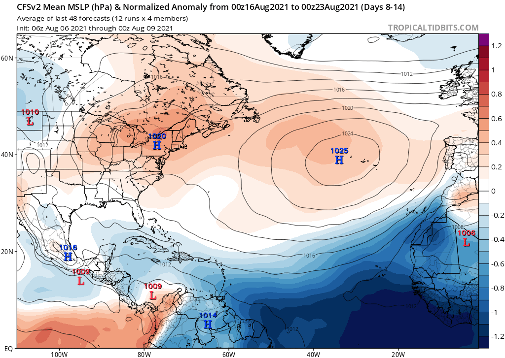
Usually when the CFS shows this within the MDR it’s often a sign of a TC outbreak… we’re getting closer :double:
1 likes   

User avatar
Category5Kaiju
Category 5
Category 5
Posts: 4097
Joined: Thu Dec 24, 2020 12:45 pm
Location: Seattle

Re: 2021 Indicators: SST's / SAL / MSLP / Shear / Steering / Instability / Sat Images

#2390 Postby Category5Kaiju » Mon Aug 09, 2021 12:24 pm


Deep blue just like the Atlantic Ocean in actual color :double:
1 likes   
Unless explicitly stated, all info in my posts is based on my own opinions and observations. Tropical storms and hurricanes can be extremely dangerous. Do not think you can beat Mother Nature. Refer to an accredited weather research agency or meteorologist if you need to make serious decisions regarding an approaching storm.

Deshaunrob17
Tropical Storm
Tropical Storm
Posts: 207
Joined: Tue Aug 18, 2020 7:49 am

Re: 2021 Indicators: SST's / SAL / MSLP / Shear / Steering / Instability / Sat Images

#2391 Postby Deshaunrob17 » Mon Aug 09, 2021 12:33 pm

Notice the the trend
Elsa was the last storm in the Atlantic which originated from the Deep Tropics, impacted the Lesser Antilles and cruised through the Caribbean and headed for the SE US.
94 L may develop depression / storm and impact the Lesser Antillies and head for the SE US. Models hinting at possible development in the Caribbean next week.
This upcoming pattern is a little concerning. Everyone in hurricane should be ready in case
5 likes   

AlphaToOmega
Category 5
Category 5
Posts: 1448
Joined: Sat Jun 26, 2021 10:51 am
Location: Somewhere in Massachusetts

Re: 2021 Indicators: SST's / SAL / MSLP / Shear / Steering / Instability / Sat Images

#2392 Postby AlphaToOmega » Mon Aug 09, 2021 1:21 pm

Image
Image
Image
Image
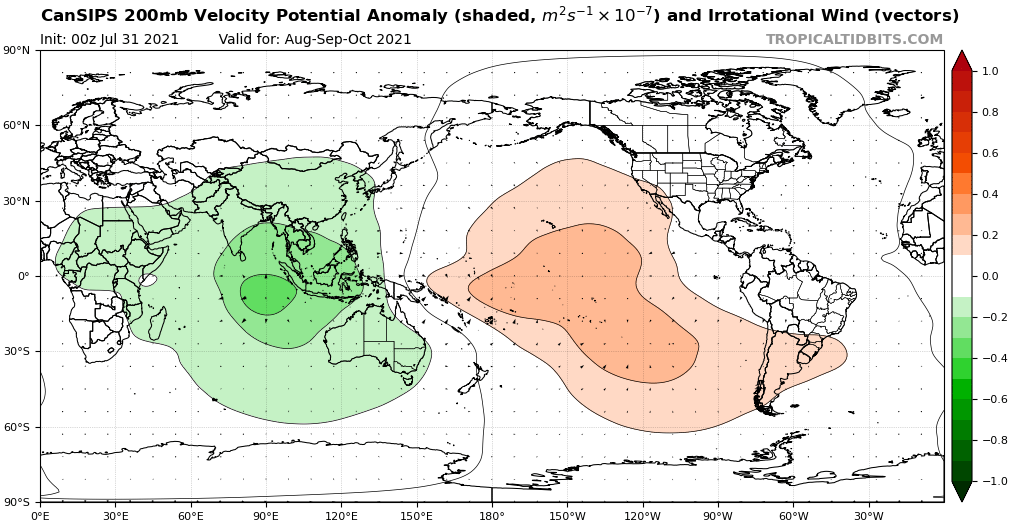
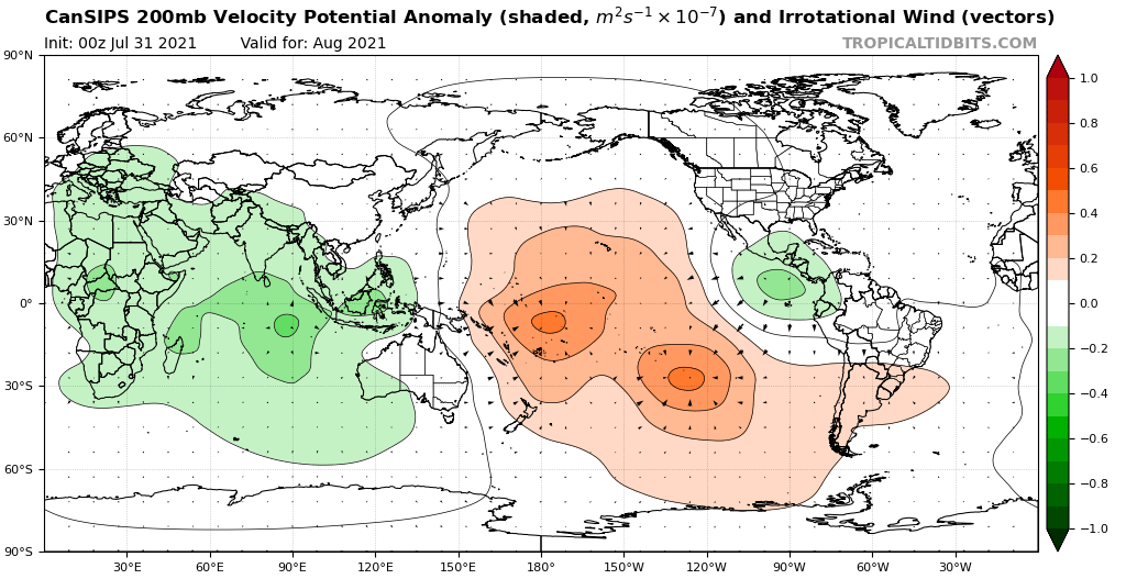
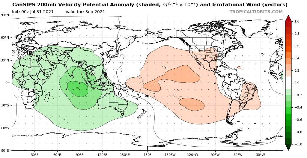
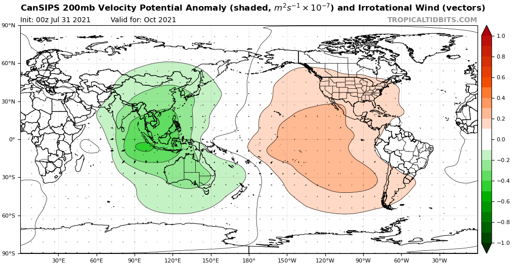
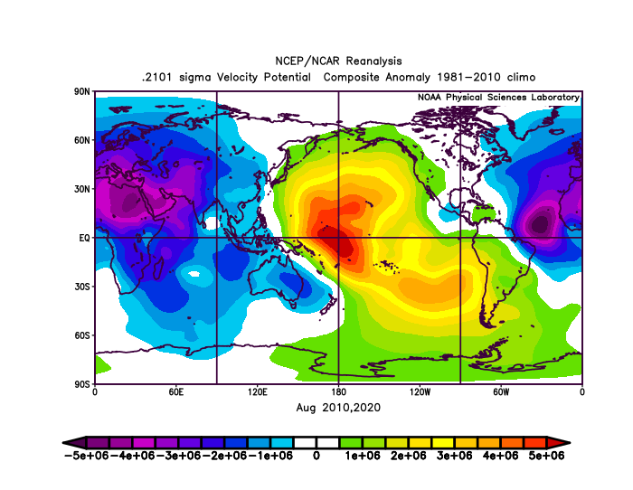
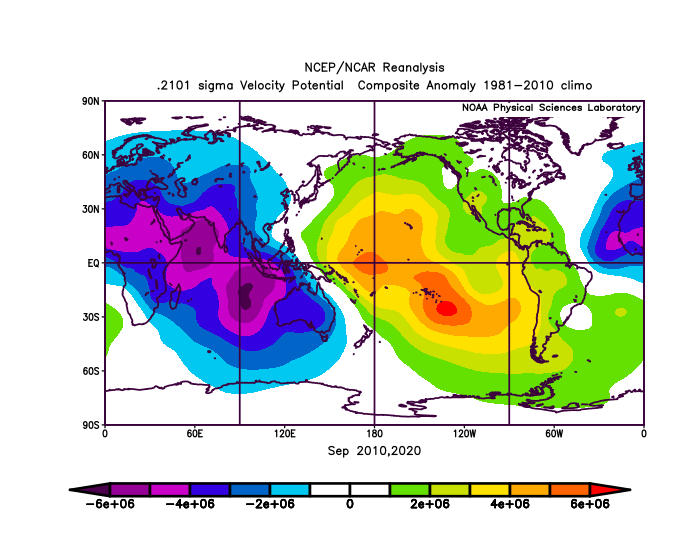
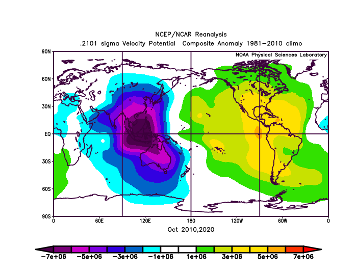
According to the CanSIPS model, the height to hurricane season activity might be in September/October. The -VP anomalies over the Indian Ocean and the Maritime Continent should greatly enhance tropical cyclogenesis. However, August will likely be decently active due to the -VP over Africa, the Indian Ocean, and the Maritime Content. In fact, these maps are nearly identical to the blended 2010 and 2020 VP anomaly maps, further supporting the idea that 2010 and 2020 are analog years for 2021.
Image
Image
Image
This means that peak season will likely be very active.
3 likes   

AlphaToOmega
Category 5
Category 5
Posts: 1448
Joined: Sat Jun 26, 2021 10:51 am
Location: Somewhere in Massachusetts

Re: 2021 Indicators: SST's / SAL / MSLP / Shear / Steering / Instability / Sat Images

#2393 Postby AlphaToOmega » Mon Aug 09, 2021 1:33 pm

Source: http://www.bom.gov.au/climate/mjo/
August 2021 could be even more active than August 2020 or August 2010. August 2021 is forecasted to be dominated with Phases II and III of the MJO, which are favorable for Atlantic tropical cyclogenesis. That is something neither August 2010 nor August 2020 had.
1 likes   

User avatar
Category5Kaiju
Category 5
Category 5
Posts: 4097
Joined: Thu Dec 24, 2020 12:45 pm
Location: Seattle

Re: 2021 Indicators: SST's / SAL / MSLP / Shear / Steering / Instability / Sat Images

#2394 Postby Category5Kaiju » Mon Aug 09, 2021 2:10 pm

Personally I would not be surprised if this August we see at least 5-7 NSs form; the second half of this month look very favorable for Atlantic activity and a struggling EPAC
1 likes   
Unless explicitly stated, all info in my posts is based on my own opinions and observations. Tropical storms and hurricanes can be extremely dangerous. Do not think you can beat Mother Nature. Refer to an accredited weather research agency or meteorologist if you need to make serious decisions regarding an approaching storm.

AlphaToOmega
Category 5
Category 5
Posts: 1448
Joined: Sat Jun 26, 2021 10:51 am
Location: Somewhere in Massachusetts

Re: 2021 Indicators: SST's / SAL / MSLP / Shear / Steering / Instability / Sat Images

#2395 Postby AlphaToOmega » Mon Aug 09, 2021 2:21 pm

Category5Kaiju wrote:Personally I would not be surprised if this August we see at least 5-7 NSs form; the second half of this month look very favorable for Atlantic activity and a struggling EPAC

Seven storms in August would put us on track with 1995 and 2005: twelve storms by August 31.
0 likes   

User avatar
Category5Kaiju
Category 5
Category 5
Posts: 4097
Joined: Thu Dec 24, 2020 12:45 pm
Location: Seattle

Re: 2021 Indicators: SST's / SAL / MSLP / Shear / Steering / Instability / Sat Images

#2396 Postby Category5Kaiju » Mon Aug 09, 2021 2:35 pm

As we are now seeing with 94L about to achieve TC status and models indicating more activity after that, I think we are definitely seeing the switch flip with our very own eyes now. This is the thing, merely a week ago there was talk of this season busting and not being able to live up to its predicted activity levels, but as always, the August magic looks to be ready to do its thing, and who knows what we’ll be seeing later this month and in September? It’s only a matter of time folks, so be prepared!
6 likes   
Unless explicitly stated, all info in my posts is based on my own opinions and observations. Tropical storms and hurricanes can be extremely dangerous. Do not think you can beat Mother Nature. Refer to an accredited weather research agency or meteorologist if you need to make serious decisions regarding an approaching storm.

tolakram
Admin
Admin
Posts: 20009
Age: 62
Joined: Sun Aug 27, 2006 8:23 pm
Location: Florence, KY (name is Mark)

Re: 2021 Indicators: SST's / SAL / MSLP / Shear / Steering / Instability / Sat Images

#2397 Postby tolakram » Mon Aug 09, 2021 2:43 pm

There's been more talk about people talking about the season busting than there has been actual talk about the season busting. :)
12 likes   
M a r k
- - - - -
Join us in chat: Storm2K Chatroom Invite. Android and IOS apps also available.

The posts in this forum are NOT official forecasts and should not be used as such. Posts are NOT endorsed by any professional institution or STORM2K.org. For official information and forecasts, please refer to NHC and NWS products.

User avatar
captainbarbossa19
Professional-Met
Professional-Met
Posts: 1092
Age: 27
Joined: Wed Aug 21, 2019 11:09 pm
Location: Beaumont, TX

Re: 2021 Indicators: SST's / SAL / MSLP / Shear / Steering / Instability / Sat Images

#2398 Postby captainbarbossa19 » Mon Aug 09, 2021 2:45 pm

Shell Mound wrote:https://twitter.com/jetsflyinghigh/status/1424453732566290442

A permanent “season cancel” for Southeast Florida: (in-)famous “last words”...? :eek: At least some people are already complacent, unfortunately.


That person better watch it according to this chart from NOAA.

Image

Source: www.nhc.noaa.gov/climo/images/return_hurr.jpg
1 likes   

User avatar
toad strangler
S2K Supporter
S2K Supporter
Posts: 4543
Joined: Sun Jul 28, 2013 3:09 pm
Location: Earth
Contact:

Re: 2021 Indicators: SST's / SAL / MSLP / Shear / Steering / Instability / Sat Images

#2399 Postby toad strangler » Mon Aug 09, 2021 3:03 pm

captainbarbossa19 wrote:
Shell Mound wrote:https://twitter.com/jetsflyinghigh/status/1424453732566290442

A permanent “season cancel” for Southeast Florida: (in-)famous “last words”...? :eek: At least some people are already complacent, unfortunately.


That person better watch it according to this chart from NOAA.

https://i.imgur.com/nvPQmNW.jpg

Source: http://www.nhc.noaa.gov/climo/images/return_hurr.jpg


THose NOAA return rate maps are very cool but can be misleading if one doesn't know better. Those return rates are not actual strikes but are for when a center passes within 50 nautical miles of the location.
2 likes   

User avatar
captainbarbossa19
Professional-Met
Professional-Met
Posts: 1092
Age: 27
Joined: Wed Aug 21, 2019 11:09 pm
Location: Beaumont, TX

Re: 2021 Indicators: SST's / SAL / MSLP / Shear / Steering / Instability / Sat Images

#2400 Postby captainbarbossa19 » Mon Aug 09, 2021 3:09 pm

toad strangler wrote:
captainbarbossa19 wrote:
Shell Mound wrote:https://twitter.com/jetsflyinghigh/status/1424453732566290442

A permanent “season cancel” for Southeast Florida: (in-)famous “last words”...? :eek: At least some people are already complacent, unfortunately.


That person better watch it according to this chart from NOAA.

https://i.imgur.com/nvPQmNW.jpg

Source: http://www.nhc.noaa.gov/climo/images/return_hurr.jpg


THose NOAA return rate maps are very cool but can be misleading if one doesn't know better. Those return rates are not actual strikes but are for when a center passes within 50 nautical miles of the location.


True. Here are actual hurricane strikes from 1900-2010.

Image

Source: http://www.nhc.noaa.gov/climo/images/strikes_egulf.jpg
0 likes   


Return to “Talkin' Tropics”

Who is online

Users browsing this forum: jconsor, KeysRedWine, Ulf and 51 guests