2024 Global Model Runs Discussion (Out thru day 16)
Moderator: S2k Moderators
Forum rules

The posts in this forum are NOT official forecasts and should not be used as such. They are just the opinion of the poster and may or may not be backed by sound meteorological data. They are NOT endorsed by any professional institution or STORM2K. For official information, please refer to products from the National Hurricane Center and National Weather Service.
-
Astromanía
- Category 2

- Posts: 793
- Age: 27
- Joined: Sat Aug 25, 2018 10:34 pm
- Location: Monterrey, N.L, México
Re: 2024 Global Model Runs Discussion (Out thru day 16)
chaser1 wrote:toad strangler wrote:12z GEFS has a good size cluster in the vicinity of Jamaica at 240 hours. That's about as far as I'll look for a signal. Need the Euro to show something similar to really raise an eyebrow.
Agreed. That would certainly be an alarm bell to me if either the EURO or the ICON were to chime in with a similar GFS solution. The other thing that I was just about to post (but SFLcane beat me to it LOL), is the fact that the GFS continues to show genesis as we move closer in time. No moving of the goal posts thus far.
Well looks like the ECMWF heard you, at the end of the lastest run it has broad circulation starting to form up in the Caribbean, still a long way off and likely to change or not happen.

1 likes
Re: 2024 Global Model Runs Discussion (Out thru day 16)
That is some pretty sticky goal posts as far as genesis. Even with Nadine the GFS was pretty much on it with genesis, just not track

1 likes

Re: 2024 Global Model Runs Discussion (Out thru day 16)
Looks like this is legit.
Huge anti-cyclone developing in the Carib in 2 days.
Huge anti-cyclone developing in the Carib in 2 days.
0 likes


Re: 2024 Global Model Runs Discussion (Out thru day 16)
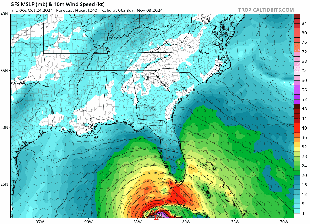
06z GFS is determined to continue Florida's hurricane rampage this year and also adds Cuba to the mix.


0 likes
Re: 2024 Global Model Runs Discussion (Out thru day 16)
alot of the 6Z gfs ensembles are east of the operational, east of florida.....
0 likes
-
Blown Away

- S2K Supporter

- Posts: 10253
- Joined: Wed May 26, 2004 6:17 am
Re: 2024 Global Model Runs Discussion (Out thru day 16)
06z GFS
0 likes
Hurricane Eye Experience: David 79, Irene 99, Frances 04, Jeanne 04, Wilma 05… Hurricane Brush Experience: Andrew 92, Erin 95, Floyd 99, Matthew 16, Irma 17, Ian 22, Nicole 22…
-
toad strangler

- S2K Supporter
- Posts: 4546
- Joined: Sun Jul 28, 2013 3:09 pm
- Location: Earth
- Contact:
Re: 2024 Global Model Runs Discussion (Out thru day 16)
mantis83 wrote:alot of the 6Z gfs ensembles are east of the operational, east of florida.....
True, although personally I stop looking at even ensembles past 240 hours. But in the spirit of the thread being to 384 hours, yep latest run weighted to the E of FL. Cuba gets smoked.
0 likes
My Weather Station
https://www.wunderground.com/dashboard/pws/KFLPORTS603
https://www.wunderground.com/dashboard/pws/KFLPORTS603

Re: 2024 Global Model Runs Discussion (Out thru day 16)
Operational Euro and CMC are starting to catch onto this potential TC. Odds are good we see something develop between Oct 30th-Nov 3rd.
2 likes
Irene '11 Sandy '12 Hermine '16 5/15/2018 Derecho Fay '20 Isaias '20 Elsa '21 Henri '21 Ida '21
I am only a meteorology enthusiast who knows a decent amount about tropical cyclones. Look to the professional mets, the NHC, or your local weather office for the best information.
I am only a meteorology enthusiast who knows a decent amount about tropical cyclones. Look to the professional mets, the NHC, or your local weather office for the best information.
-
USTropics
- Professional-Met

- Posts: 2736
- Joined: Sun Aug 12, 2007 3:45 am
- Location: Florida State University
Re: 2024 Global Model Runs Discussion (Out thru day 16)
I do think we will see some type of development in the Caribbean, the MJO pulse will provide the necessary vertical ascent over the Caribbean to get something going (both the GFS and ECMWF products show this starting around Halloween):


Forecasting a track is going to be extremely difficult at this long lead time though, as the upper-level pattern over CONUS begins to transition to fall/winter in earnest. In particular, upper-level verification scores are going to be taking a hit here as the models try and figure out how to assess the first significant cut-off low of the fall/winter season. This is currently developing SE of Alaska (I like to use this product from Alicia Bentley that essentially shows our dynamic tropopause temperatures to analyze upper-level feature):

We can see this start to separate from the upper-level jet stream flow in ~48 hours:

Cutoff lows are one of the toughest upper-level features to forecast track for, and almost always leads to a degradation in model forecast verifications at longer forecast periods. Here is the full 06z GFS solution, and we can see this upper-level/cutoff low acts to amplify high pressure/ridging over the northeast United states (which allows the system to move into the GOM):

Again, want to emphasize expect adjustments to this upper level pattern. If we take a look at the trend of the last 8 GFS runs, the pattern has been everywhere:

Forecasting a track is going to be extremely difficult at this long lead time though, as the upper-level pattern over CONUS begins to transition to fall/winter in earnest. In particular, upper-level verification scores are going to be taking a hit here as the models try and figure out how to assess the first significant cut-off low of the fall/winter season. This is currently developing SE of Alaska (I like to use this product from Alicia Bentley that essentially shows our dynamic tropopause temperatures to analyze upper-level feature):
We can see this start to separate from the upper-level jet stream flow in ~48 hours:
Cutoff lows are one of the toughest upper-level features to forecast track for, and almost always leads to a degradation in model forecast verifications at longer forecast periods. Here is the full 06z GFS solution, and we can see this upper-level/cutoff low acts to amplify high pressure/ridging over the northeast United states (which allows the system to move into the GOM):
Again, want to emphasize expect adjustments to this upper level pattern. If we take a look at the trend of the last 8 GFS runs, the pattern has been everywhere:
14 likes
-
toad strangler
- S2K Supporter
- Posts: 4546
- Joined: Sun Jul 28, 2013 3:09 pm
- Location: Earth
- Contact:
-
Stormlover70
- Tropical Storm

- Posts: 194
- Age: 56
- Joined: Fri Jun 21, 2024 5:31 am
- Location: New port richey
Re: 2024 Global Model Runs Discussion (Out thru day 16)
I was referring to storms hitting florida back to back.HurricaneBelle wrote:Stormlover70 wrote:2004 vibes back to back grrrr
2004 shut off pretty much after Jeanne/Karl by around October 1. This is more 1995, 2005 or 2020.

0 likes
-
MEANINGLESS_NUMBERS
- Category 2
- Posts: 503
- Joined: Mon Nov 02, 2020 1:43 pm
Re: 2024 Global Model Runs Discussion (Out thru day 16)
Election day hurricane.
1 likes
Emily '87, Felix '95, Gert '99, Fabian '03, Humberto '19, Paulette '20, Teddy '20, Fiona '22, Lee '23, Ernesto '24, Humberto/Imelda '25
-
WeatherBoy2000
- Category 1

- Posts: 460
- Joined: Mon Apr 10, 2023 9:29 am
Re: 2024 Global Model Runs Discussion (Out thru day 16)
toad strangler wrote:https://twitter.com/bennollweather/status/1849425860253868196?s=46
Can we know for sure that this will be the last chance for hurricanes? I know it'll be the very end of October/the first week of November, but given this year's performance stating this definitively might still be jumping the gun. We've seen major hurricanes as late as November 20th or so in the Atlantic (Otto/Kate) along with other major hurricanes during the middle of the month. It is still unlikely, but with how warm the Atlantic is, I think that there's a higher chance that more intense activity could still develop later on.
4 likes


Re: 2024 Global Model Runs Discussion (Out thru day 16)
MEANINGLESS_NUMBERS wrote:
Election day hurricane.
Cannot imagine the unprecedented implications of that.
5 likes
Re: 2024 Global Model Runs Discussion (Out thru day 16)
When do you think the NHC will start including this development in the outlooks?
0 likes

Re: 2024 Global Model Runs Discussion (Out thru day 16)
MetroMike wrote:MEANINGLESS_NUMBERS wrote:
Election day hurricane.
Cannot imagine the unprecedented implications of that.
Not only would it be devastating but it could fuel the wacko conspiracy theory that the bogey man can control hurricanes.
10 likes

Re: 2024 Global Model Runs Discussion (Out thru day 16)
06z GFS looks like a carbon copy of Milton track across Florida. This season we've had a similar pattern of landfall with Debby, Helene, and Milton. All eastern GOM storms. Weird how some years you can get repeated strikes. Climatology does argue that if a storm forms in the western Caribbean it will be tough for it to make the latitude of Tampa before being steered off to the east in the westelies. Seems like south Florida and the keys need to be watching this one closely.
5 likes
Re: 2024 Global Model Runs Discussion (Out thru day 16)
GCANE wrote:Looks like this is legit.
Huge anti-cyclone developing in the Carib in 2 days.
Yeah Gcane....somethings on the horizon....as a footnote...I commented yesterday on several news agencies...whom I shall not name...are reporting this possibility...before the NHC has even designated an area of interest....but based on what yall here are discussing....I have little doubt that there will be development in the Carribean....but no idea if a cyclone will form...or who...if any area...will be impacted....i read that the setup that kept Oscar away from the CONUS....has changed...so that leads me to believe that if something forms....there could quite possibly be some concerns for the CONUS?....I dunmo tho....I rely on yall...and the NHC for that info...
0 likes
Who is online
Users browsing this forum: hcane27 and 73 guests