2017 Global Model Runs Discussion (Out to day 16)

This is the general tropical discussion area. Anyone can take their shot at predicting a storms path.

Moderator: S2k Moderators

Forum rules

The posts in this forum are NOT official forecasts and should not be used as such. They are just the opinion of the poster and may or may not be backed by sound meteorological data. They are NOT endorsed by any professional institution or STORM2K. For official information, please refer to products from the National Hurricane Center and National Weather Service.

Help Support Storm2K
Message
Author
AutoPenalti
Category 5
Category 5
Posts: 3950
Age: 27
Joined: Mon Aug 17, 2015 4:16 pm
Location: Ft. Lauderdale, Florida

Re: 2017 Global Model Runs Discussion (Out to day 16)

#241 Postby AutoPenalti » Fri Jun 02, 2017 1:33 am

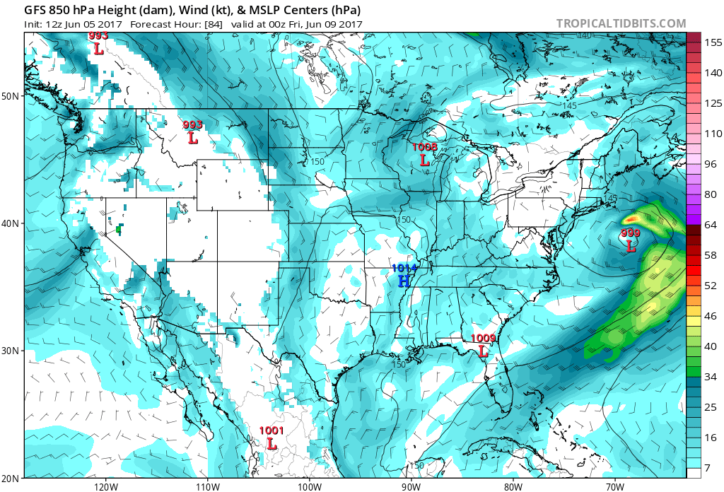
Hammy wrote:If the GFS is showing phantom storms this early, could that be an indicator that the base conditions are more favorable than recent years?

It could be, but it also could be GFS being GFS.
0 likes   
The posts in this forum are NOT official forecasts and should not be used as such. They are just the opinion of the poster and may or may not be backed by sound meteorological data. They are NOT endorsed by any professional institution or STORM2K. For official information, please refer to products from the NHC and NWS.


Model Runs Cheat Sheet:
GFS (5:30 AM/PM, 11:30 AM/PM)
HWRF, GFDL, UKMET, NAVGEM (6:30-8:00 AM/PM, 12:30-2:00 AM/PM)
ECMWF (1:45 AM/PM)

TCVN
is a weighted averaged

User avatar
tarheelprogrammer
S2K Supporter
S2K Supporter
Posts: 1793
Joined: Mon Mar 28, 2016 9:25 pm
Location: Raleigh, NC area (Garner, NC)

Re: 2017 Global Model Runs Discussion (Out to day 16)

#242 Postby tarheelprogrammer » Fri Jun 02, 2017 8:56 am

Models are really struggling right now. Even the ECMWF.
0 likes   
My posts are not official forecasts. They are just my opinion and may or may not be backed by sound meteorological data. They are NOT endorsed by any professional institution or storm2k.org. For official information, please refer to the NHC and NWS products.

User avatar
weathaguyry
Category 5
Category 5
Posts: 1272
Age: 21
Joined: Wed Jun 15, 2016 5:16 am
Location: Long Island, NY

Re: 2017 Global Model Runs Discussion (Out to day 16)

#243 Postby weathaguyry » Fri Jun 02, 2017 6:15 pm

Hmmm, probably just normal GFS phantom garbage, but it has been persistent with this for a few runs now, it will be interesting to see if the Euro has it once it comes into range.

Image
0 likes   
My posts are only my opinions and NOT official forecasts. For official forecasts, consult the National Hurricane Center or the National Weather Service.

Irene 11', Sandy 12', Fay 20’, Isaias 20’, Elsa 21’, Henri 21’, Ida 21’

AutoPenalti
Category 5
Category 5
Posts: 3950
Age: 27
Joined: Mon Aug 17, 2015 4:16 pm
Location: Ft. Lauderdale, Florida

Re: 2017 Global Model Runs Discussion (Out to day 16)

#244 Postby AutoPenalti » Fri Jun 02, 2017 6:31 pm

weathaguyry wrote:Hmmm, probably just normal GFS phantom garbage, but it has been persistent with this for a few runs now, it will be interesting to see if the Euro has it once it comes into range.

Image


It keeps pushing it back.
2 likes   
The posts in this forum are NOT official forecasts and should not be used as such. They are just the opinion of the poster and may or may not be backed by sound meteorological data. They are NOT endorsed by any professional institution or STORM2K. For official information, please refer to products from the NHC and NWS.


Model Runs Cheat Sheet:
GFS (5:30 AM/PM, 11:30 AM/PM)
HWRF, GFDL, UKMET, NAVGEM (6:30-8:00 AM/PM, 12:30-2:00 AM/PM)
ECMWF (1:45 AM/PM)

TCVN
is a weighted averaged

User avatar
Hurricaneman
Category 5
Category 5
Posts: 7285
Age: 43
Joined: Tue Aug 31, 2004 3:24 pm
Location: central florida

Re: 2017 Global Model Runs Discussion (Out to day 16)

#245 Postby Hurricaneman » Fri Jun 02, 2017 6:54 pm

AutoPenalti wrote:
weathaguyry wrote:Hmmm, probably just normal GFS phantom garbage, but it has been persistent with this for a few runs now, it will be interesting to see if the Euro has it once it comes into range.

http://www.tropicaltidbits.com/analysis ... ics_48.png


It keeps pushing it back.


Based on the GFS pushback it's definitely a phantom storm
2 likes   

User avatar
TheStormExpert
Category 5
Category 5
Posts: 8487
Age: 30
Joined: Wed Feb 16, 2011 5:38 pm
Location: Palm Beach Gardens, FL

Re: 2017 Global Model Runs Discussion (Out to day 16)

#246 Postby TheStormExpert » Fri Jun 02, 2017 7:02 pm

Hurricaneman wrote:
AutoPenalti wrote:
weathaguyry wrote:Hmmm, probably just normal GFS phantom garbage, but it has been persistent with this for a few runs now, it will be interesting to see if the Euro has it once it comes into range.

http://www.tropicaltidbits.com/analysis ... ics_48.png


It keeps pushing it back.


Based on the GFS pushback it's definitely a phantom storm

The takeaway from it is the GFS is advertising that conditions will become more favorable for tropical development sooner rather than later.
1 likes   
The following post is NOT an official forecast and should not be used as such. It is just the opinion of the poster and may or may not be backed by sound meteorological data. It is NOT endorsed by storm2k.org.

User avatar
gatorcane
S2K Supporter
S2K Supporter
Posts: 23499
Age: 46
Joined: Sun Mar 13, 2005 3:54 pm
Location: Boca Raton, FL

Re: 2017 Global Model Runs Discussion (Out to day 16)

#247 Postby gatorcane » Fri Jun 02, 2017 7:45 pm

The area to watch will be the Western Caribbean / Yucatán in the long-range as we head into mid June. Shear looks like it could begin to relax there and models are starting to spin up things down there (including the ECMWF) not to mention that is the climatologically favored area. The GFS shear anomaly graphic day 10 below:

Image
0 likes   

User avatar
Kingarabian
S2K Supporter
S2K Supporter
Posts: 15462
Joined: Sat Aug 08, 2009 3:06 am
Location: Honolulu, Hawaii

Re: 2017 Global Model Runs Discussion (Out to day 16)

#248 Postby Kingarabian » Sat Jun 03, 2017 3:44 am

GFS and Euro seem to be keying in on another 50/50 system that will develop either in the western Caribbean or Eastern Pacific.
0 likes   
RIP Kobe Bryant

User avatar
NDG
S2K Supporter
S2K Supporter
Posts: 14951
Joined: Sun Jul 09, 2006 10:14 pm
Location: Orlando, FL

Re: 2017 Global Model Runs Discussion (Out to day 16)

#249 Postby NDG » Sun Jun 04, 2017 7:27 am

Worst performance by the Euro going now during the past year, almost as bad as the GFS. So I guess certain patterns give models a real hard time to forecast.

https://twitter.com/bigjoebastardi/stat ... 5262349313
Image
0 likes   

User avatar
cycloneye
Admin
Admin
Posts: 139752
Age: 67
Joined: Thu Oct 10, 2002 10:54 am
Location: San Juan, Puerto Rico

Re: 2017 Global Model Runs Discussion (Out to day 16)

#250 Postby cycloneye » Mon Jun 05, 2017 11:19 am

Note from Levi on a delay to the 12z run of GFS.

12:10pm EDT June 5: The NOAA data feed is experiencing problems, currently delaying 12Z GFS output. Other American models may be affected as well.
0 likes   
Visit the Caribbean-Central America Weather Thread where you can find at first post web cams,radars
and observations from Caribbean basin members Click Here

User avatar
South Texas Storms
Professional-Met
Professional-Met
Posts: 4041
Joined: Thu Jun 24, 2010 12:28 am
Location: Houston, TX

Re: 2017 Global Model Runs Discussion (Out to day 16)

#251 Postby South Texas Storms » Mon Jun 05, 2017 11:24 am

It looks like the ECMWF is scheduled to be upgraded sometime next month.

Weatherbell has a link on their paid site providing data from the Euro Parallel run.
0 likes   

User avatar
tropicwatch
Category 5
Category 5
Posts: 3208
Age: 60
Joined: Sat Jun 02, 2007 10:01 am
Location: Panama City Florida
Contact:

Re: 2017 Global Model Runs Discussion (Out to day 16)

#252 Postby tropicwatch » Mon Jun 05, 2017 12:20 pm

cycloneye wrote:Note from Levi on a delay to the 12z run of GFS.

12:10pm EDT June 5: The NOAA data feed is experiencing problems, currently delaying 12Z GFS output. Other American models may be affected as well.


NOAA has had several issues over the past week or so. There RSS feeds were not updating (fixed), the ssd satellite feeds were not updating this weekend (fixed today).
0 likes   
Tropicwatch


Agnes 72', Eloise 75, Elena 85', Kate 85', Charley 86', Florence 88', Beryl 94', Dean 95', Erin 95', Opal 95', Earl 98', Georges 98', Ivan 2004', Arlene 2005', Dennis 2005', Ida 2009' Debby 2012' Irma 2017' Michael 2018'

User avatar
TheStormExpert
Category 5
Category 5
Posts: 8487
Age: 30
Joined: Wed Feb 16, 2011 5:38 pm
Location: Palm Beach Gardens, FL

Re: 2017 Global Model Runs Discussion (Out to day 16)

#253 Postby TheStormExpert » Mon Jun 05, 2017 12:56 pm

The 12z Euro is not loading now either.

EDIT: Never mind it's starting to load now.
0 likes   
The following post is NOT an official forecast and should not be used as such. It is just the opinion of the poster and may or may not be backed by sound meteorological data. It is NOT endorsed by storm2k.org.

User avatar
stormhunter7
Category 2
Category 2
Posts: 733
Joined: Mon May 26, 2008 3:13 pm
Location: Panama City Beach, Florida
Contact:

Re: 2017 Global Model Runs Discussion (Out to day 16)

#254 Postby stormhunter7 » Mon Jun 05, 2017 1:29 pm

GEM has shown a GOM TS storm for the last 3 runs now around the 15th of June......
0 likes   
The following post is NOT an official forecast and should not be used as such. It is just the opinion of the poster and may or may not be backed by sound meteorological data. It is NOT endorsed by any professional institution including storm2k.org For Official Information please refer to the NHC and NWS products. http://www.nhc.noaa.gov

User avatar
tropicwatch
Category 5
Category 5
Posts: 3208
Age: 60
Joined: Sat Jun 02, 2007 10:01 am
Location: Panama City Florida
Contact:

Re: 2017 Global Model Runs Discussion (Out to day 16)

#255 Postby tropicwatch » Mon Jun 05, 2017 1:40 pm

Both the GFS and Euro show the low coming off of Texas moving eastward across the north gulf and possibly deepening off the east coast during the week.

Image
Image
0 likes   
Tropicwatch


Agnes 72', Eloise 75, Elena 85', Kate 85', Charley 86', Florence 88', Beryl 94', Dean 95', Erin 95', Opal 95', Earl 98', Georges 98', Ivan 2004', Arlene 2005', Dennis 2005', Ida 2009' Debby 2012' Irma 2017' Michael 2018'

User avatar
cycloneye
Admin
Admin
Posts: 139752
Age: 67
Joined: Thu Oct 10, 2002 10:54 am
Location: San Juan, Puerto Rico

Re: 2017 Global Model Runs Discussion (Out to day 16)

#256 Postby cycloneye » Tue Jun 06, 2017 1:07 pm

0 likes   
Visit the Caribbean-Central America Weather Thread where you can find at first post web cams,radars
and observations from Caribbean basin members Click Here

User avatar
wxman57
Moderator-Pro Met
Moderator-Pro Met
Posts: 22512
Age: 66
Joined: Sat Jun 21, 2003 8:06 pm
Location: Houston, TX (southwest)

Re: 2017 Global Model Runs Discussion (Out to day 16)

#257 Postby wxman57 » Tue Jun 06, 2017 2:38 pm

Western Caribbean/eastern Gulf is a prime early-season development region. GFS is picking up on potential development there in 11-12 days. Conditions in that region are looking favorable for development, but that doesn't mean the GFS is correct. Let's see if the EC and Canadian come on board in 3-4 days once the potential development is within 10 days. For now, I'd say development chances there around the 16th-18th may be 10-15%.
0 likes   

User avatar
Kingarabian
S2K Supporter
S2K Supporter
Posts: 15462
Joined: Sat Aug 08, 2009 3:06 am
Location: Honolulu, Hawaii

Re: 2017 Global Model Runs Discussion (Out to day 16)

#258 Postby Kingarabian » Wed Jun 07, 2017 2:36 am

00z Euro has develoment on the EPAC side.
0 likes   
RIP Kobe Bryant

Alyono
Professional-Met
Professional-Met
Posts: 6961
Joined: Fri Apr 26, 2013 3:52 pm
Location: Texas Coast

Re: 2017 Global Model Runs Discussion (Out to day 16)

#259 Postby Alyono » Wed Jun 07, 2017 3:04 am

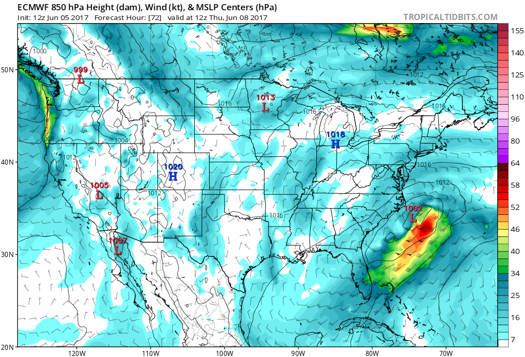
Kingarabian wrote:00z Euro has develoment on the EPAC side.


any Caribbean or Gulf development is likely to begin just after the 240 hour time period. Given how the monsoon trough sets up, no matter which side a well defined LLC forms, it likely would move toward the Gulf
0 likes   

User avatar
TheStormExpert
Category 5
Category 5
Posts: 8487
Age: 30
Joined: Wed Feb 16, 2011 5:38 pm
Location: Palm Beach Gardens, FL

Re: 2017 Global Model Runs Discussion (Out to day 16)

#260 Postby TheStormExpert » Wed Jun 07, 2017 7:44 am

Can't trust any of these global models beyond a few days with how well they've been doing over the past month or so. It's a wait and see situation at this point.
0 likes   
The following post is NOT an official forecast and should not be used as such. It is just the opinion of the poster and may or may not be backed by sound meteorological data. It is NOT endorsed by storm2k.org.


Return to “Talkin' Tropics”

Who is online

Users browsing this forum: cajungal, Google Adsense [Bot], USTropics and 58 guests