2020 Indicators: SST's / SAL / MSLP / Steering / Shear / Instability / Sat Images

This is the general tropical discussion area. Anyone can take their shot at predicting a storms path.

Moderator: S2k Moderators

Forum rules

The posts in this forum are NOT official forecasts and should not be used as such. They are just the opinion of the poster and may or may not be backed by sound meteorological data. They are NOT endorsed by any professional institution or STORM2K. For official information, please refer to products from the National Hurricane Center and National Weather Service.

Help Support Storm2K
Message
Author
TheStormExpert

Re: 2020 Indicators: SST's / SAL / MSLP / Steering / Shear / Instability / Sat Images

#2421 Postby TheStormExpert » Wed Aug 12, 2020 6:35 pm

Kingarabian wrote:
cycloneye wrote:Not so fast but eventually the Atlantic will turn active.

[url]https://twitter.com/ToddKimberlain/status/1293632339784892418[url]

These are good points. But the fact of the matter is that these aren't like the big bad 2014-2018 EPAC systems. Most of these modeled systems are either much smaller in size so limited outflow and much weaker than forecast. Also a lot of these systems have had to move further west in order to develop. The global models EPAC TC exaggeration is on another level this year.

Still though, how many of us even thought the East Pacific would produce after being mostly dormant from mid-May through July outside of Douglas?
0 likes   

User avatar
Steve
S2K Supporter
S2K Supporter
Posts: 9620
Joined: Sat Apr 05, 2003 11:41 pm
Location: Not a state-caster

Re: 2020 Indicators: SST's / SAL / MSLP / Steering / Shear / Instability / Sat Images

#2422 Postby Steve » Wed Aug 12, 2020 7:29 pm

Probably everybody right? It’s the EPAC. There’s going to be something.
3 likes   

User avatar
gatorcane
S2K Supporter
S2K Supporter
Posts: 23691
Age: 47
Joined: Sun Mar 13, 2005 3:54 pm
Location: Boca Raton, FL

Re: 2020 Indicators: SST's / SAL / MSLP / Steering / Shear / Instability / Sat Images

#2423 Postby gatorcane » Wed Aug 12, 2020 7:42 pm

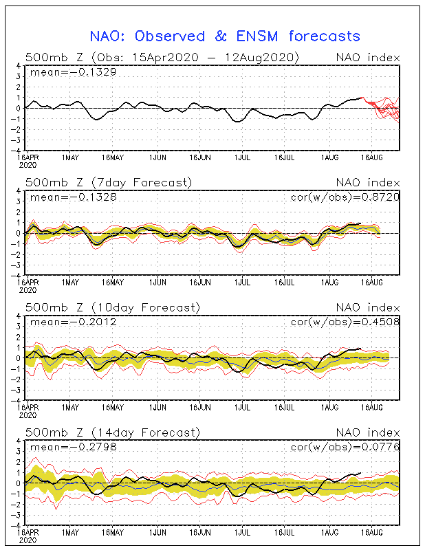
Noticed the NAO may be going back into negative territory over the next couple of weeks which could mean troughiness over the eastern seaboard of the US:

Image
0 likes   

User avatar
NDG
S2K Supporter
S2K Supporter
Posts: 15446
Joined: Sun Jul 09, 2006 10:14 pm
Location: Orlando, FL

Re: 2020 Indicators: SST's / SAL / MSLP / Steering / Shear / Instability / Sat Images

#2424 Postby NDG » Wed Aug 12, 2020 8:03 pm

gatorcane wrote:Noticed the NAO may be going back into negative territory over the next couple of weeks which could mean troughiness over the eastern seaboard of the US:

https://i.postimg.cc/JhGcYzzv/nao-sprd2.gif


Notice that ~90% July was in a -NAO pattern, but there was nothing close to a troughiness pattern across the eastern seaboard, overall.
Glad you used the word "could" :D

Image
3 likes   

hurricaneCW
Category 5
Category 5
Posts: 1794
Joined: Wed Mar 03, 2010 6:20 am
Location: Toms River, NJ

Re: 2020 Indicators: SST's / SAL / MSLP / Steering / Shear / Instability / Sat Images

#2425 Postby hurricaneCW » Wed Aug 12, 2020 8:21 pm

gatorcane wrote:Noticed the NAO may be going back into negative territory over the next couple of weeks which could mean troughiness over the eastern seaboard of the US:

https://i.postimg.cc/JhGcYzzv/nao-sprd2.gif


I don't think so, we're very likely going to see the same ole pattern with strong eastern Canadian and northern new England ridging.

MJO heading to phase 8-2 strongly favors east coast impacts.
4 likes   

User avatar
MississippiWx
S2K Supporter
S2K Supporter
Posts: 1699
Joined: Sat Aug 14, 2010 1:44 pm
Location: Hattiesburg, Mississippi

Re: 2020 Indicators: SST's / SAL / MSLP / Steering / Shear / Instability / Sat Images

#2426 Postby MississippiWx » Wed Aug 12, 2020 9:12 pm

gatorcane wrote:Noticed the NAO may be going back into negative territory over the next couple of weeks which could mean troughiness over the eastern seaboard of the US:

https://i.postimg.cc/JhGcYzzv/nao-sprd2.gif


-NAO in the summer does not equal -NAO in the winter.
0 likes   
This post is not an official forecast and should not be used as such. It is just the opinion of MississippiWx and may or may not be backed by sound meteorological data. It is not endorsed by any professional institution including storm2k.org. For Official Information please refer to the NHC and NWS products.

User avatar
1900hurricane
Category 5
Category 5
Posts: 6059
Age: 34
Joined: Fri Feb 06, 2015 12:04 pm
Location: Houston, TX
Contact:

Re: 2020 Indicators: SST's / SAL / MSLP / Steering / Shear / Instability / Sat Images

#2427 Postby 1900hurricane » Wed Aug 12, 2020 9:43 pm

Still approaching the climatological big hit of activity.

Image
2 likes   
Contract Meteorologist. TAMU & MSST. Fiercely authentic, one of a kind. We are all given free will, so choose a life meant to be lived. We are the Masters of our own Stories.
Opinions expressed are mine alone.

Follow me on Twitter at @1900hurricane : Read blogs at https://1900hurricane.wordpress.com/

USTropics
Professional-Met
Professional-Met
Posts: 2650
Joined: Sun Aug 12, 2007 3:45 am
Location: Florida State University

Re: 2020 Indicators: SST's / SAL / MSLP / Steering / Shear / Instability / Sat Images

#2428 Postby USTropics » Wed Aug 12, 2020 10:53 pm

1900hurricane wrote:Instead of looking at named storms, why not look at ACE instead? It's possible VPA will have a stronger correlation with that. Here's how seasons beginning in 1950 ranked in terms of ACE for the August 15-31st time period. The top ten seasons are highlighted in yellow.

https://i.imgur.com/yjDSwa9.png


Love your work, is your ACE/TIKE DB public by chance? I thought you linked it one time but not seeing it on your site. There's a lack of being able to efficiently track individual ACE by storm or specific time periods (working with iBTrACS but going to be a bit before I finish that project -https://www.ncdc.noaa.gov/ibtracs/index.php?name=ib-v4-access). All but 2007 are included in the VP anomalies I posted above with 4+ storms in the second 1/2 of August. Similarly observed VP anomaly patterns are present in 2007:
Image

Using all 10 of your ACE selected years, only 2004 differentiates from observed positive VP anomalies over Africa/IO in the latter half of August:
Image

Composite of all 10 ACE selected season:
Image
3 likes   

User avatar
Steve
S2K Supporter
S2K Supporter
Posts: 9620
Joined: Sat Apr 05, 2003 11:41 pm
Location: Not a state-caster

Re: 2020 Indicators: SST's / SAL / MSLP / Steering / Shear / Instability / Sat Images

#2429 Postby Steve » Wed Aug 12, 2020 11:32 pm

http://mikeventrice.weebly.com/mjo.html

Still Phase 6, but we'll be in Phase 7 or the circle heading toward 8 by tomorrow according to the GFS. If' I've got the timing right, expect a few spin-ups along the way, but more expect a burst after August 27th. GFS has again moved its most concentrated area of upward motion farther east to where it's now centered across the lower portion of Central America. Delay that 4-6 days and you're in around September 1st to the 3rd. From then on, things are liable to be wild at least for a few weeks if you go with the GFS.
2 likes   


User avatar
SFLcane
S2K Supporter
S2K Supporter
Posts: 10163
Age: 47
Joined: Sat Jun 05, 2010 1:44 pm
Location: Lake Worth Florida

Re: 2020 Indicators: SST's / SAL / MSLP / Steering / Shear / Instability / Sat Images

#2431 Postby SFLcane » Thu Aug 13, 2020 9:04 am

2 likes   

User avatar
SFLcane
S2K Supporter
S2K Supporter
Posts: 10163
Age: 47
Joined: Sat Jun 05, 2010 1:44 pm
Location: Lake Worth Florida

Re: 2020 Indicators: SST's / SAL / MSLP / Steering / Shear / Instability / Sat Images

#2432 Postby SFLcane » Thu Aug 13, 2020 9:16 am

2 likes   

User avatar
SFLcane
S2K Supporter
S2K Supporter
Posts: 10163
Age: 47
Joined: Sat Jun 05, 2010 1:44 pm
Location: Lake Worth Florida

Re: 2020 Indicators: SST's / SAL / MSLP / Steering / Shear / Instability / Sat Images

#2433 Postby SFLcane » Thu Aug 13, 2020 9:21 am

Once the epac quites down and the MJO+ strong KW move into the Atlantic it could be a historic outbreak just around the corner.
3 likes   

User avatar
crownweather
S2K Supporter
S2K Supporter
Posts: 595
Age: 50
Joined: Sat Aug 12, 2006 9:21 am
Location: Sturbridge, Massachusetts
Contact:

Re: 2020 Indicators: SST's / SAL / MSLP / Steering / Shear / Instability / Sat Images

#2434 Postby crownweather » Thu Aug 13, 2020 9:23 am

Meaning the GFS model is going to be playing catch-up BIG TIME in the next couple of weeks with TC formation forecasts.

 https://twitter.com/MJVentrice/status/1293914771515944960


9 likes   
Rob Lightbown
Crown Weather Services
https://crownweather.com

User avatar
Kazmit
Category 5
Category 5
Posts: 2124
Age: 22
Joined: Mon Jul 25, 2016 8:49 am
Location: Williamsburg, VA / Bermuda

Re: 2020 Indicators: SST's / SAL / MSLP / Steering / Shear / Instability / Sat Images

#2435 Postby Kazmit » Thu Aug 13, 2020 9:26 am

IMO it's looking like the lid may come off about a week later than usual- the very end of August instead of around the 20th.
2 likes   
Igor 2010, Sandy 2012, Fay 2014, Gonzalo 2014, Joaquin 2015, Nicole 2016, Humberto 2019

I am only a tropical weather enthusiast. My predictions are not official and may or may not be backed by sound meteorological data. For official information, please refer to the NHC and NWS products.

User avatar
Cpv17
Category 5
Category 5
Posts: 4975
Joined: Wed Dec 07, 2016 2:24 pm
Location: Wharton/El Campo, TX

Re: 2020 Indicators: SST's / SAL / MSLP / Steering / Shear / Instability / Sat Images

#2436 Postby Cpv17 » Thu Aug 13, 2020 9:53 am

Kazmit wrote:IMO it's looking like the lid may come off about a week later than usual- the very end of August instead of around the 20th.


I’d say sometime after the 25th.
0 likes   

User avatar
Steve
S2K Supporter
S2K Supporter
Posts: 9620
Joined: Sat Apr 05, 2003 11:41 pm
Location: Not a state-caster

Re: 2020 Indicators: SST's / SAL / MSLP / Steering / Shear / Instability / Sat Images

#2437 Postby Steve » Thu Aug 13, 2020 10:14 am

Cpv17 wrote:
Kazmit wrote:IMO it's looking like the lid may come off about a week later than usual- the very end of August instead of around the 20th.


I’d say sometime after the 25th.


Reasonable. I think it's a few days after that (very late August/beginning of September). We might get to Kyle or Laura by then, but it's still kind of pre-peak.

GFS has finally come on board with the majority of the MJO models to no longer stick around the far 8/1 border. It's now dropping into 8 by the weekend and then should be firmly in 1 by the end of the run (8/27).

Global Forecast System - GFS
Image

Climate Forecast System - CFS
Image

Canadian
Image

European (note - this run keeps it playing around in Phase 1)
Image

Japanese Model - JMA (note that it still wants to drop it straight to favorable across the circle. It usually only updates on NCEP's site once a week. It's headed for Phase 2, but I don't think that's the way it gets there.
Image
0 likes   

User avatar
EquusStorm
Category 5
Category 5
Posts: 1649
Age: 34
Joined: Thu Nov 07, 2013 1:04 pm
Location: Jasper, AL
Contact:

Re: 2020 Indicators: SST's / SAL / MSLP / Steering / Shear / Instability / Sat Images

#2438 Postby EquusStorm » Thu Aug 13, 2020 10:19 am

Is the usual GOES imagery high-res source on the NHC site from NESDIS consistently down for everyone lately or just me
0 likes   
Colors of lost purpose on the canvas of irrelevance

Not a meteorologist, in fact more of an idiot than anything. You should probably check with the NHC or a local NWS office for official information.

User avatar
SFLcane
S2K Supporter
S2K Supporter
Posts: 10163
Age: 47
Joined: Sat Jun 05, 2010 1:44 pm
Location: Lake Worth Florida

Re: 2020 Indicators: SST's / SAL / MSLP / Steering / Shear / Instability / Sat Images

#2439 Postby SFLcane » Thu Aug 13, 2020 10:26 am

Stop hugging the long-range GFS folks..

 https://twitter.com/MJVentrice/status/1293914771515944960


3 likes   

User avatar
Steve
S2K Supporter
S2K Supporter
Posts: 9620
Joined: Sat Apr 05, 2003 11:41 pm
Location: Not a state-caster

Re: 2020 Indicators: SST's / SAL / MSLP / Steering / Shear / Instability / Sat Images

#2440 Postby Steve » Thu Aug 13, 2020 10:35 am

SFLcane wrote:Stop hugging the long-range GFS folks..

https://twitter.com/MJVentrice/status/1293914771515944960


That's been a recent topic of discussion. You've had to adjust it for known biases to come up with what you really think will happen. One of those known biases is what it's been doing in the EPAC vs. what's actually happening. Plus we know the MJO isn't going to stay in that region and will progress across the Atlantic. So the proverbial "with a grain of salt" definitely applies when looking at it.
4 likes   


Return to “Talkin' Tropics”

Who is online

Users browsing this forum: No registered users and 38 guests