


2022 Global Model Runs Discussion (Out thru day 16)
Moderator: S2k Moderators
Forum rules

The posts in this forum are NOT official forecasts and should not be used as such. They are just the opinion of the poster and may or may not be backed by sound meteorological data. They are NOT endorsed by any professional institution or STORM2K. For official information, please refer to products from the National Hurricane Center and National Weather Service.
Re: 2022 Global Model Runs Discussion (Out thru day 16)
This is one fantastical wish map for Nov 8 : 200 mb 384 gfs+++
1 likes
List of 79 tropical cyclones intercepted by Richard Horodner:
http://www.canebeard.com/page/page/572246.htm
former storm2k screenname Beoumont 2009+
http://www.canebeard.com/page/page/572246.htm
former storm2k screenname Beoumont 2009+
Re: 2022 Global Model Runs Discussion (Out thru day 16)
dexterlabio wrote:LarryWx wrote:
I still think the GFS is out to lunch with its climo unflavored E Caribbean geneses. The two recent runs being the weakest through late next week in the E Car are imho hinting to us that that is the case and that it will quite possibly stop showing E Car geneses within a few runs. OTOH, the 18Z GEFS is about as active with geneses in early November in the W Car as has been the case with any recent run. This is similar to the increased activity there on the two most recent EPS runs though the GEFS is quite a bit more active. Imho, it is the C or W Caribbean where we should be wary about a possible TCG next week rather than the E Car that the GFS has been insisting on.
Do you think this is one of those moments of the GFS north/east "bias"?
Until you asked, I wasn't thinking about that. But perhaps kind of sort of in this case because of overdevelopment? Regardless, the GFS has seemingly had a bias this season to develop stuff coming off SA.
1 likes
Personal Forecast Disclaimer:
The posts in this forum are NOT official forecasts and should not be used as such. They are just the opinion of the poster and may or may not be backed by sound meteorological data. They are NOT endorsed by any professional institution or storm2k.org. For official information, please refer to the NHC and NWS products.
The posts in this forum are NOT official forecasts and should not be used as such. They are just the opinion of the poster and may or may not be backed by sound meteorological data. They are NOT endorsed by any professional institution or storm2k.org. For official information, please refer to the NHC and NWS products.
-
Category5Kaiju

- Category 5

- Posts: 4332
- Joined: Thu Dec 24, 2020 12:45 pm
- Location: Seattle and Phoenix
Re: 2022 Global Model Runs Discussion (Out thru day 16)
I think where the storm goes can be focused on later rather than now; what genuinely intrigues me is how there is consensus that SOMETHING may try to develop in the Caribbean around Halloween and become a decently robust hurricane. Tis the spooky season.... 
3 likes
Unless explicitly stated, all info in my posts is based on my own opinions and observations. Tropical storms and hurricanes can be extremely dangerous. Refer to an accredited weather research agency or meteorologist if you need to make serious decisions regarding an approaching storm.
Re: 2022 Global Model Runs Discussion (Out thru day 16)
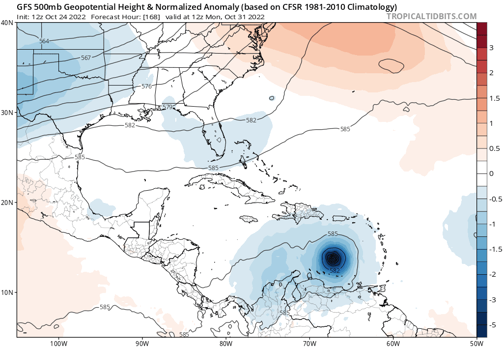
And now the 0Z GFS at hour 198 has the strongest H it has had at that forecast timeframe with 970 mb S of Hispaniola.
0 likes
Personal Forecast Disclaimer:
The posts in this forum are NOT official forecasts and should not be used as such. They are just the opinion of the poster and may or may not be backed by sound meteorological data. They are NOT endorsed by any professional institution or storm2k.org. For official information, please refer to the NHC and NWS products.
The posts in this forum are NOT official forecasts and should not be used as such. They are just the opinion of the poster and may or may not be backed by sound meteorological data. They are NOT endorsed by any professional institution or storm2k.org. For official information, please refer to the NHC and NWS products.


Re: 2022 Global Model Runs Discussion (Out thru day 16)
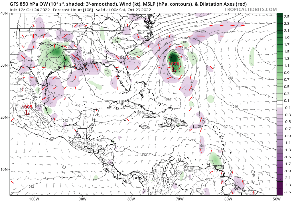
GFS has been moving the Caribbean disturbance forward in time pretty quickly. Closed low is nearly within short-range.


2 likes

Re: 2022 Global Model Runs Discussion (Out thru day 16)
06Z GFS has a very strong TC south of Hispaniola.
It appears the run-to-run tendency is moving the general track west.
It appears the run-to-run tendency is moving the general track west.
2 likes

Re: 2022 Global Model Runs Discussion (Out thru day 16)
After having had the two weakest runs (yesterday's 12Z and 18Z) since the string of GFS ECar Hs started with the 6Z 10/21 run, the last two runs (0Z/6Z) have gone the opposite way to the strongest through hour 198 (12Z on 11/1)! I still think the GFS' idea of a H in the ECar is wrong and that any TCG, if there is any, would likely wait til the C or WCar. This is quite the interesting situation from a forecasting perspective with such major differences persisting among the main models!
0 likes
Personal Forecast Disclaimer:
The posts in this forum are NOT official forecasts and should not be used as such. They are just the opinion of the poster and may or may not be backed by sound meteorological data. They are NOT endorsed by any professional institution or storm2k.org. For official information, please refer to the NHC and NWS products.
The posts in this forum are NOT official forecasts and should not be used as such. They are just the opinion of the poster and may or may not be backed by sound meteorological data. They are NOT endorsed by any professional institution or storm2k.org. For official information, please refer to the NHC and NWS products.

Re: 2022 Global Model Runs Discussion (Out thru day 16)
LarryWx wrote:After having had the two weakest runs (yesterday's 12Z and 18Z) since the string of GFS ECar Hs started with the 6Z 10/21 run, the last two runs (0Z/6Z) have gone the opposite way to the strongest through hour 198 (12Z on 11/1)! I still think the GFS' idea of a H in the ECar is wrong and that any TCG, if there is any, would likely wait til the C or WCar. This is quite the interesting situation from a forecasting perspective with such major differences persisting among the main models!
The EPS so far with a weak signal favoring the W. Caribbean. I think everyone is waiting to see which way the Euro OPS goes once it starts to show up. Will be interesting for sure.

1 likes
The following post is NOT an official forecast and should not be used as such. It is just the opinion of the poster and may or may not be backed by sound meteorological data. It is NOT endorsed by any professional institution including storm2k.org For Official Information please refer to the NHC and NWS products.

Re: 2022 Global Model Runs Discussion (Out thru day 16)
12z GFS starts development even earlier than previous runs, on October 29th instead of the 30th/31st.
1 likes
Irene '11 Sandy '12 Hermine '16 5/15/2018 Derecho Fay '20 Isaias '20 Elsa '21 Henri '21 Ida '21
I am only a meteorology enthusiast who knows a decent amount about tropical cyclones. Look to the professional mets, the NHC, or your local weather office for the best information.
I am only a meteorology enthusiast who knows a decent amount about tropical cyclones. Look to the professional mets, the NHC, or your local weather office for the best information.
-
chris_fit

- Category 5
- Posts: 3261
- Age: 43
- Joined: Wed Sep 10, 2003 11:58 pm
- Location: Tampa Bay Area, FL
Re: 2022 Global Model Runs Discussion (Out thru day 16)
CMC drops it for the 2nd run in a row.
0 likes
Re: 2022 Global Model Runs Discussion (Out thru day 16)
aspen wrote:12z GFS starts development even earlier than previous runs, on October 29th instead of the 30th/31st.
After having the two weakest runs since the 6Z 10/21 run at 12Z and 18Z yesterday and thus looking to me like it was quite possibly getting close to giving up on a H in the E Car, these last 3 (0Z, 6Z, 12Z) have been the strongest in the E Car! I still think the exclusive to GFS idea of a H in the E Car from this is out to lunch based on a combo of bias, relative lack of model support, and climo and that a TCG from this, if any, would thus wait til the C or W Caribbean, but we'll see. The GFS has done this kind of thing in the past where it would stubbornly hold onto a H run after run on its own only to later abandon it, sometimes abruptly. It is almost as if the GFS is a trolling model at times lol.
Last edited by LarryWx on Mon Oct 24, 2022 12:17 pm, edited 2 times in total.
0 likes
Personal Forecast Disclaimer:
The posts in this forum are NOT official forecasts and should not be used as such. They are just the opinion of the poster and may or may not be backed by sound meteorological data. They are NOT endorsed by any professional institution or storm2k.org. For official information, please refer to the NHC and NWS products.
The posts in this forum are NOT official forecasts and should not be used as such. They are just the opinion of the poster and may or may not be backed by sound meteorological data. They are NOT endorsed by any professional institution or storm2k.org. For official information, please refer to the NHC and NWS products.
-
gatorcane

- S2K Supporter

- Posts: 23708
- Age: 48
- Joined: Sun Mar 13, 2005 3:54 pm
- Location: Boca Raton, FL
Re: 2022 Global Model Runs Discussion (Out thru day 16)
12Z GFS says not so far South Florida as far as getting out of 2022 unscathed. Thankfully in the long-range: 
2 likes
Re: 2022 Global Model Runs Discussion (Out thru day 16)
chris_fit wrote:CMC drops it for the 2nd run in a row.
I think what it dropped was W.Carribean orgin solution. If you look at the 850mb vorticity on rhe last two runs it has shifted closer to the GFS in the E. Carribean but unlike the GFS it is too quick and it gets strung out with the big low over SW Atlantic and gets pulled apart.
For now the Icon, CMC, GFS going fo E Carribean origin. Models trending with more ridging in the longer range so it may end up in the W.Carribean anyways in the long range.
4 likes
The following post is NOT an official forecast and should not be used as such. It is just the opinion of the poster and may or may not be backed by sound meteorological data. It is NOT endorsed by any professional institution including storm2k.org For Official Information please refer to the NHC and NWS products.
Re: 2022 Global Model Runs Discussion (Out thru day 16)
LarryWx wrote:aspen wrote:12z GFS starts development even earlier than previous runs, on October 29th instead of the 30th/31st.
After having the two weakest runs since the 6Z 10/21 run at 12Z and 18Z yesterday and thus looking to me like it was quite possible getting close to gaining up on a H in the E Car, these last 3 (0Z, 6Z, 12Z) have been the strongest in the E Car! I still think the exclusive to GFS idea of a H in the E Car from this is out to lunch based on a combo of bias, relative lack of model support, and climo and that a TCG from this, if any, would thus wait til the C or W Caribbean, but we'll see. The GFS has done this kind of thing in the past where it would stubbornly hold onto a H run after run on its own only to later abandon it, sometimes abruptly. It is almost as if the GFS is a trolling model at times lol.
Always appreciate the analysis. A couple points though. I think historically the GFS development bias is based primarily in the W.Carribean and not E. Carribean but I could be wrong. Second it does have the Icon and to a lesser degree the CMC with similar ideas so it's not on an island with model support. I do agree we can't trust the upper pattern forecast for one minute with the GFS. Patiently waiting for the Euro to clear things up, hopefully soon.
1 likes
The following post is NOT an official forecast and should not be used as such. It is just the opinion of the poster and may or may not be backed by sound meteorological data. It is NOT endorsed by any professional institution including storm2k.org For Official Information please refer to the NHC and NWS products.
-
Blown Away

- S2K Supporter
- Posts: 10253
- Joined: Wed May 26, 2004 6:17 am
Re: 2022 Global Model Runs Discussion (Out thru day 16)
12z GFS… Showing system in medium range starting in E Caribbean in 4 days, then the rest is fantasy…
1 likes
Hurricane Eye Experience: David 79, Irene 99, Frances 04, Jeanne 04, Wilma 05… Hurricane Brush Experience: Andrew 92, Erin 95, Floyd 99, Matthew 16, Irma 17, Ian 22, Nicole 22…


Re: 2022 Global Model Runs Discussion (Out thru day 16)
Like Joe Bastardi noted GFS shows a Kate Track back in 1985 which was the strongest Hurricane in the Gulf that late in the year according to him.
0 likes
-
chris_fit
- Category 5
- Posts: 3261
- Age: 43
- Joined: Wed Sep 10, 2003 11:58 pm
- Location: Tampa Bay Area, FL
Re: 2022 Global Model Runs Discussion (Out thru day 16)
12z GEFS are active, but all over the place. Never seem them so unclustered.

0 likes
Re: 2022 Global Model Runs Discussion (Out thru day 16)
I know this is way out there, but GFS is pretty good about forecasting UL conditions.
If a TC finds its way into the GOM, GFS is showing a massive ARWB in the GoM.
The deepest I have ever seen.
Like I said, this is way out there.
Hopefully, a TC won't develop or if it does, it gets shredded in the Antilles.
If a TC finds its way into the GOM, GFS is showing a massive ARWB in the GoM.
The deepest I have ever seen.
Like I said, this is way out there.
Hopefully, a TC won't develop or if it does, it gets shredded in the Antilles.
2 likes
Re: 2022 Global Model Runs Discussion (Out thru day 16)
blp wrote:LarryWx wrote:aspen wrote:12z GFS starts development even earlier than previous runs, on October 29th instead of the 30th/31st.
After having the two weakest runs since the 6Z 10/21 run at 12Z and 18Z yesterday and thus looking to me like it was quite possible getting close to gaining up on a H in the E Car, these last 3 (0Z, 6Z, 12Z) have been the strongest in the E Car! I still think the exclusive to GFS idea of a H in the E Car from this is out to lunch based on a combo of bias, relative lack of model support, and climo and that a TCG from this, if any, would thus wait til the C or W Caribbean, but we'll see. The GFS has done this kind of thing in the past where it would stubbornly hold onto a H run after run on its own only to later abandon it, sometimes abruptly. It is almost as if the GFS is a trolling model at times lol.
Always appreciate the analysis. A couple points though. I think historically the GFS development bias is based primarily in the W.Carribean and not E. Carribean but I could be wrong. Second it does have the Icon and to a lesser degree the CMC with similar ideas so it's not on an island with model support. I do agree we can't trust the upper pattern forecast for one minute with the GFS. Patiently waiting for the Euro to clear things up, hopefully soon.
Thank you.
I mean that the GFS has had an overdevelopment bias this season in the southern Caribbean off of South America. I'm wary of that coming into play now.
The 12Z ICON doesn't have actual TCG until the C Caribbean and it isn't more than a TS as of hour 180. And sometimes the ICON has overdone things this season. The 12Z CMC has only a very weak low and no TCG. The 12Z UK, Euro, and JMA have very little til a weak low in the SW Car. I'm currently more interested in that part of the Car for potential TCG next week. These model wars make these forecasting threads extra fun!
The GFS is developing this at least partially from vorticity located now per the model near 9N, 50W. I wonder how it is looking there right now.
0 likes
Personal Forecast Disclaimer:
The posts in this forum are NOT official forecasts and should not be used as such. They are just the opinion of the poster and may or may not be backed by sound meteorological data. They are NOT endorsed by any professional institution or storm2k.org. For official information, please refer to the NHC and NWS products.
The posts in this forum are NOT official forecasts and should not be used as such. They are just the opinion of the poster and may or may not be backed by sound meteorological data. They are NOT endorsed by any professional institution or storm2k.org. For official information, please refer to the NHC and NWS products.
Who is online
Users browsing this forum: JoshwaDone and 114 guests