2022 Indicators (SSTs/SAL/MSLP/Shear/Steering/Instability) and >Day 16 Models

This is the general tropical discussion area. Anyone can take their shot at predicting a storms path.

Moderator: S2k Moderators

Forum rules

The posts in this forum are NOT official forecasts and should not be used as such. They are just the opinion of the poster and may or may not be backed by sound meteorological data. They are NOT endorsed by any professional institution or STORM2K. For official information, please refer to products from the National Hurricane Center and National Weather Service.

Help Support Storm2K
Message
Author
User avatar
skyline385
Category 5
Category 5
Posts: 2520
Age: 33
Joined: Wed Aug 26, 2020 11:15 pm
Location: Houston TX

Re: 2022 Indicators (SSTs/SAL/MSLP/Shear/Steering/Instability) and >Day 16 Models

#2481 Postby skyline385 » Thu Aug 04, 2022 8:24 pm

cycloneye wrote:I notice a mood that is not a happy one here today so I will atempt to change it with this.

https://twitter.com/AndyHazelton/status/1555227623684558854

https://twitter.com/dmorris9661/status/1555230159191642112


This will probably improve the mood here further, completely forgot today was weekly day.

 https://twitter.com/AndyHazelton/status/1555300254534275081


A lot of OTS storms potential in today's run :D

Image

Precip plots are a different story though

Image
Last edited by skyline385 on Thu Aug 04, 2022 8:34 pm, edited 2 times in total.
5 likes   

User avatar
cycloneye
Admin
Admin
Posts: 139493
Age: 67
Joined: Thu Oct 10, 2002 10:54 am
Location: San Juan, Puerto Rico

Re: 2022 Indicators (SSTs/SAL/MSLP/Shear/Steering/Instability) and >Day 16 Models

#2482 Postby cycloneye » Thu Aug 04, 2022 8:27 pm

skyline385 wrote:
cycloneye wrote:I notice a mood that is not a happy one here today so I will atempt to change it with this.

https://twitter.com/AndyHazelton/status/1555227623684558854

https://twitter.com/dmorris9661/status/1555230159191642112


This will probably improve the mood here further, completely forgot today was weekly day.

https://twitter.com/AndyHazelton/status/1555300254534275081


Waiting for NMME. When does it come out?
0 likes   
Visit the Caribbean-Central America Weather Thread where you can find at first post web cams,radars
and observations from Caribbean basin members Click Here

IsabelaWeather
Tropical Storm
Tropical Storm
Posts: 220
Age: 34
Joined: Tue Jul 07, 2020 7:29 am
Location: Isabela, Puerto Rico

Re: 2022 Indicators (SSTs/SAL/MSLP/Shear/Steering/Instability) and >Day 16 Models

#2483 Postby IsabelaWeather » Thu Aug 04, 2022 8:28 pm

How do we go from "warm subtropics are bad" to "cold subtropics are bad" in the blink of an eye and now there wont be any storms because of it when a few days ago it was hugely important that subtropics are colder?
11 likes   

User avatar
skyline385
Category 5
Category 5
Posts: 2520
Age: 33
Joined: Wed Aug 26, 2020 11:15 pm
Location: Houston TX

Re: 2022 Indicators (SSTs/SAL/MSLP/Shear/Steering/Instability) and >Day 16 Models

#2484 Postby skyline385 » Thu Aug 04, 2022 8:28 pm

cycloneye wrote:
skyline385 wrote:
cycloneye wrote:I notice a mood that is not a happy one here today so I will atempt to change it with this.

https://twitter.com/AndyHazelton/status/1555227623684558854

https://twitter.com/dmorris9661/status/1555230159191642112


This will probably improve the mood here further, completely forgot today was weekly day.

https://twitter.com/AndyHazelton/status/1555300254534275081


Waiting for NMME. When does it come out?


I think NMME is 7th and SEAS5 is tomorrow.
0 likes   

User avatar
AnnularCane
S2K Supporter
S2K Supporter
Posts: 2653
Joined: Thu Jun 08, 2006 9:18 am
Location: Wytheville, VA

Re: 2022 Indicators (SSTs/SAL/MSLP/Shear/Steering/Instability) and >Day 16 Models

#2485 Postby AnnularCane » Thu Aug 04, 2022 8:28 pm

Everyone knew the numbers would likely be lowered a little and that it would likely not mean much if at all. At least that seemed to be the case before they actually came out. 8-)
0 likes   
"But it never rained rain. It never snowed snow. And it never blew just wind. It rained things like soup and juice. It snowed mashed potatoes and green peas. And sometimes the wind blew in storms of hamburgers." -- Judi Barrett, Cloudy with a Chance of Meatballs

User avatar
NotSparta
Professional-Met
Professional-Met
Posts: 1658
Age: 22
Joined: Fri Aug 18, 2017 8:24 am
Location: Naples, FL
Contact:

Re: 2022 Indicators (SSTs/SAL/MSLP/Shear/Steering/Instability) and >Day 16 Models

#2486 Postby NotSparta » Thu Aug 04, 2022 8:28 pm

cycloneye wrote:
skyline385 wrote:
cycloneye wrote:I notice a mood that is not a happy one here today so I will atempt to change it with this.

https://twitter.com/AndyHazelton/status/1555227623684558854

https://twitter.com/dmorris9661/status/1555230159191642112


This will probably improve the mood here further, completely forgot today was weekly day.

https://twitter.com/AndyHazelton/status/1555300254534275081


Waiting for NMME. When does it come out?


Should come out on Sunday
2 likes   
This post was probably an opinion of mine, and in no way is official. Please refer to http://www.hurricanes.gov for official tropical analysis and advisories.

My website, with lots of tropical wx graphics, including satellite and recon: http://cyclonicwx.com

User avatar
cycloneye
Admin
Admin
Posts: 139493
Age: 67
Joined: Thu Oct 10, 2002 10:54 am
Location: San Juan, Puerto Rico

Re: 2022 Indicators (SSTs/SAL/MSLP/Shear/Steering/Instability) and >Day 16 Models

#2487 Postby cycloneye » Thu Aug 04, 2022 8:50 pm

NotSparta wrote:
cycloneye wrote:
skyline385 wrote:
This will probably improve the mood here further, completely forgot today was weekly day.

https://twitter.com/AndyHazelton/status/1555300254534275081


Waiting for NMME. When does it come out?


Should come out on Sunday


Thank you. That model had a very active season in July and that is why I want to see if it mantains that.
1 likes   
Visit the Caribbean-Central America Weather Thread where you can find at first post web cams,radars
and observations from Caribbean basin members Click Here

Patrick99
Category 5
Category 5
Posts: 1759
Joined: Mon May 24, 2004 3:43 pm
Location: Miami, FL

Re: 2022 Indicators (SSTs/SAL/MSLP/Shear/Steering/Instability) and >Day 16 Models

#2488 Postby Patrick99 » Thu Aug 04, 2022 8:56 pm

What is "wavebreaking?" Is it just a buzzword for dry air suppressing tropical waves?
0 likes   

zzh
Category 1
Category 1
Posts: 375
Joined: Fri Aug 27, 2021 2:18 pm

Re: 2022 Indicators (SSTs/SAL/MSLP/Shear/Steering/Instability) and >Day 16 Models

#2489 Postby zzh » Thu Aug 04, 2022 9:15 pm

Again, subtropics is not a whole. The parts that are unrelated to seasonal ace or even negatively affect ace are the western and central part, not the eastern part.
6 likes   

User avatar
skyline385
Category 5
Category 5
Posts: 2520
Age: 33
Joined: Wed Aug 26, 2020 11:15 pm
Location: Houston TX

Re: 2022 Indicators (SSTs/SAL/MSLP/Shear/Steering/Instability) and >Day 16 Models

#2490 Postby skyline385 » Thu Aug 04, 2022 9:24 pm

zzh wrote:Again, subtropics is not a whole. The parts that are unrelated to seasonal ace or even negatively affect ace are the western and central part, not the eastern part.


Its also visible on the ACE-SST plots from the CSU forecasts

Image
0 likes   

User avatar
aspen
Category 5
Category 5
Posts: 8059
Joined: Sat Oct 12, 2019 7:10 pm
Location: Connecticut, USA

Re: 2022 Indicators (SSTs/SAL/MSLP/Shear/Steering/Instability) and >Day 16 Models

#2491 Postby aspen » Thu Aug 04, 2022 11:10 pm

skyline385 wrote:
cycloneye wrote:I notice a mood that is not a happy one here today so I will atempt to change it with this.

https://twitter.com/AndyHazelton/status/1555227623684558854

https://twitter.com/dmorris9661/status/1555230159191642112


This will probably improve the mood here further, completely forgot today was weekly day.

https://twitter.com/AndyHazelton/status/1555300254534275081

A lot of OTS storms potential in today's run :D

https://i.imgur.com/mIJkoO1.png

Precip plots are a different story though

https://i.imgur.com/gjfFRKp.png

What hasn’t changed about the Euro weekly TCG chance map is the heightened possibility of something off the mid-Atlantic coast. It’s been on there for weeks now. It’s hard to tell if it’s either a frontal spin-up, or one of the several possible MDR systems that get dragged north.
0 likes   
Irene '11 Sandy '12 Hermine '16 5/15/2018 Derecho Fay '20 Isaias '20 Elsa '21 Henri '21 Ida '21

I am only a meteorology enthusiast who knows a decent amount about tropical cyclones. Look to the professional mets, the NHC, or your local weather office for the best information.

User avatar
captainbarbossa19
Category 5
Category 5
Posts: 1040
Joined: Wed Aug 21, 2019 11:09 pm
Location: Starkville, MS

Re: 2022 Indicators (SSTs/SAL/MSLP/Shear/Steering/Instability) and >Day 16 Models

#2492 Postby captainbarbossa19 » Thu Aug 04, 2022 11:24 pm

IsabelaWeather wrote:How do we go from "warm subtropics are bad" to "cold subtropics are bad" in the blink of an eye and now there wont be any storms because of it when a few days ago it was hugely important that subtropics are colder?


It reminds me of that "season-cancel" diagram that someone posted on here a few weeks ago. It doesn't matter what the topic is. Everything eventually leads to season-cancel it seems. :spam:

In all seriousness, I think this season has a lot more going for it than against it. It is just a matter of time before we have storms to track.
4 likes   

User avatar
AJC3
Admin
Admin
Posts: 3876
Age: 60
Joined: Tue Aug 31, 2004 7:04 pm
Location: West Melbourne, Florida
Contact:

Re: 2022 Indicators (SSTs/SAL/MSLP/Shear/Steering/Instability) and >Day 16 Models

#2493 Postby AJC3 » Fri Aug 05, 2022 3:15 am

Patrick99 wrote:What is "wavebreaking?" Is it just a buzzword for dry air suppressing tropical waves?


You can think of it much like an ocean wave. Cyclonic wave breaking (CWB) occurs when the amplitude of a mid-upper level short wave trough becomes too large compared to its wavelength. Anticyclonic wave breaking (AWB) occurs when the amplitude of a mid-upper level short wave ridge becomes too large compared to its wavelength. The processes of both CWB and AWB are accompanied by and increase in deformation and wind shear, which creates unvfavorable/less favorable conditions when and where it occurs. In this case, I believe the wave breaking being referred to is AWB.

In the context of the (sub)tropics, let's look at the semi-permanent mid-oceanic TUTT. Its strongest reflection occurs at about 200MB, In the summer, when amplification of the NHEM flow occurs (i.e. development of short wave troughs and ridges), wave breaking will eventually occur when they reach the Atlantic basin and are of significant amplitude (they drill far enough south into the subtropics), and invariably interact with the TUTT to some degree. During the wave break process, the resulant amplification of the TUTT causes the upper level westerlies to strengthen and drop southward from the subtropics into the central-western Atlantic MDR. After an AWB occurs, development (and westward retrogression) of a cutoff low results, although these cutoffs vary greatly in terms of size, strength, persistence, movement, etc. Generally a piece of the TUTT fractures off an retrogrades westward underneath the rebuilding mid-upper ridge. This stronger winds/shear will then move away from the area as retrogression occurs. This is cyclical, and more frequent wave breaking is a sign of more frequent interaction between between northern stream Atlantic troughs and the TUTT. In my experience, this more frequent interaction occurs when there is anamalously strong mid-upper ridging over NOAM/CONUS (think heat waves), which causes lower heights downstream over the Atlantic. However, this doesn't seem to be the case as 500-200MB heights have been above normal across virtually the entire Atlantic since 1 JUL.

Explaining atmospheric waves, breaks and the TUTT isn't the easiest thing in the world to do while keeping it simple, but hopefully this helps you grasp the concept a little.

[soapbox]
As I've stated in previous posts, I don't count all mid to upper level troughs/lows in the subtropics as TUTTs, only ones which have significant interaction with the TUTT . The others I'll often refer to as "TUTT-type" lows. Operationally here in Florida, I've found that there's an important difference in that a true TUTT (troughs or cutoff low) will almost always have a weaker reflection at 500MB than a non TUTT counterpart. (TUTT has been overused/incorrectly applied to non-TUTT features, but that's a rant for another day). [/soapbox]
12 likes   

User avatar
SFLcane
S2K Supporter
S2K Supporter
Posts: 9620
Age: 46
Joined: Sat Jun 05, 2010 1:44 pm
Location: Lake Worth Florida

Re: 2022 Indicators (SSTs/SAL/MSLP/Shear/Steering/Instability) and >Day 16 Models

#2494 Postby SFLcane » Fri Aug 05, 2022 8:26 am

We could see several long track monsters if its right! ACE values expected to be nearly 50% above average

Image
0 likes   

User avatar
skyline385
Category 5
Category 5
Posts: 2520
Age: 33
Joined: Wed Aug 26, 2020 11:15 pm
Location: Houston TX

Re: 2022 Indicators (SSTs/SAL/MSLP/Shear/Steering/Instability) and >Day 16 Models

#2495 Postby skyline385 » Fri Aug 05, 2022 9:16 am

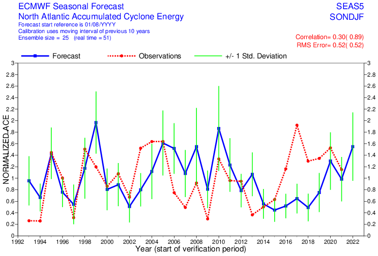
I had a feeling that the SEAS5 forecast would be overly bullish because of how the weeklies have been trending but 192 ACE is just too much especially when we don’t even have anything solid on the ensembles.

 https://twitter.com/andyhazelton/status/1555543042530189319


 https://twitter.com/andyhazelton/status/1555543371296415745


 https://twitter.com/osuwxguy/status/1555541739796107264


1 likes   

User avatar
SFLcane
S2K Supporter
S2K Supporter
Posts: 9620
Age: 46
Joined: Sat Jun 05, 2010 1:44 pm
Location: Lake Worth Florida

Re: 2022 Indicators (SSTs/SAL/MSLP/Shear/Steering/Instability) and >Day 16 Models

#2496 Postby SFLcane » Fri Aug 05, 2022 9:22 am

skyline385 wrote:I had a feeling that the SEAS5 forecast would be overly bullish because of how the weeklies have been trending but 192 ACE is just too much especially when we don’t even have anything solid on the ensembles.

https://twitter.com/andyhazelton/status/1555543042530189319

https://twitter.com/andyhazelton/status/1555543371296415745

https://twitter.com/osuwxguy/status/1555541739796107264


Its surely possible with a few long track cv storms. Mitch is an example
0 likes   

User avatar
aspen
Category 5
Category 5
Posts: 8059
Joined: Sat Oct 12, 2019 7:10 pm
Location: Connecticut, USA

Re: 2022 Indicators (SSTs/SAL/MSLP/Shear/Steering/Instability) and >Day 16 Models

#2497 Postby aspen » Fri Aug 05, 2022 9:54 am

SFLcane wrote:We could see several long track monsters if its right! ACE values expected to be nearly 50% above average

https://i.postimg.cc/QMp4tM9q/wcmwf.png

This doesn’t seem right. >190 ACE is far too high for this season at this point, but 5 hurricanes also seems a little low for a +AMO era/-ENSO year, unless this season does massively under-achieve. You’d need another Ivan or Irma to get such a high ACE per storm season, and I just don’t see that happening in a year with a northerly displaced ITCZ and possible frequent undercutting troughs.

Also, has there really been any consistent trend in the weeklies? The TCG probability map showed northerly displaced tracks and recurves, but the precipitation plot showed a possible Caribbean runner. Not much of an agreement this time around, so it doesn’t seem like there’s much of a trend other than it still showing some possibility of MDR and East Coast action.
1 likes   
Irene '11 Sandy '12 Hermine '16 5/15/2018 Derecho Fay '20 Isaias '20 Elsa '21 Henri '21 Ida '21

I am only a meteorology enthusiast who knows a decent amount about tropical cyclones. Look to the professional mets, the NHC, or your local weather office for the best information.

User avatar
DorkyMcDorkface
Category 2
Category 2
Posts: 731
Age: 26
Joined: Mon Sep 30, 2019 1:32 pm
Location: Mid-Atlantic

Re: 2022 Indicators (SSTs/SAL/MSLP/Shear/Steering/Instability) and >Day 16 Models

#2498 Postby DorkyMcDorkface » Fri Aug 05, 2022 10:07 am

SFLcane wrote:We could see several long track monsters if its right! ACE values expected to be nearly 50% above average

https://i.postimg.cc/QMp4tM9q/wcmwf.png

That's...very high lol, unrealistically so even. We'll need a 2017-esque September to even come close to sniffing that value. Don't get me wrong we'll still get decent activity next month definitely and there will likely be major hurricanes roaming the Atlantic by then but I'm willing to bet we won't get 175 ACE within 30 days.
0 likes   
Floyd 1999 | Isabel 2003 | Hanna 2008 | Irene 2011 | Sandy 2012 | Isaias 2020

User avatar
skyline385
Category 5
Category 5
Posts: 2520
Age: 33
Joined: Wed Aug 26, 2020 11:15 pm
Location: Houston TX

Re: 2022 Indicators (SSTs/SAL/MSLP/Shear/Steering/Instability) and >Day 16 Models

#2499 Postby skyline385 » Fri Aug 05, 2022 10:08 am

I also posted it in the twitter thread about how June and July have much higher correlation and less RMS error which matches Andy’s theory about August forecasts being prone to intraseasonal variations.

 https://twitter.com/osuwxguy/status/1555561692993552385


0 likes   

User avatar
Teban54
Category 5
Category 5
Posts: 1979
Joined: Sat May 19, 2018 1:19 pm

Re: 2022 Indicators (SSTs/SAL/MSLP/Shear/Steering/Instability) and >Day 16 Models

#2500 Postby Teban54 » Fri Aug 05, 2022 10:19 am

skyline385 wrote:I also posted it in the twitter thread about how June and July have much higher correlation and less RMS error which matches Andy’s theory about August forecasts being prone to intraseasonal variations.

https://twitter.com/osuwxguy/status/1555561692993552385

But as seen from the thread, June and July ACE forecasts for 2022 are also just as aggressive. And given the suppressed base state for much of July and early August, so even if the August forecast was affected by the initialization, you would expect it to be bearish, not bullish.
0 likes   


Return to “Talkin' Tropics”

Who is online

Users browsing this forum: cycloneye, HurricaneBelle, MetroMike, MGC, NotSparta, South Texas Storms, StPeteMike, Stratton23, wwizard and 46 guests