

2022 Global Model Runs Discussion (Out thru day 16)
Moderator: S2k Moderators
Forum rules

The posts in this forum are NOT official forecasts and should not be used as such. They are just the opinion of the poster and may or may not be backed by sound meteorological data. They are NOT endorsed by any professional institution or STORM2K. For official information, please refer to products from the National Hurricane Center and National Weather Service.
Re: 2022 Global Model Runs Discussion (Out thru day 16)
Even though the 12z CMC ops does not develop. The 12Z GEPS continues to be aggressive and follows the GFS track.
3 likes
The following post is NOT an official forecast and should not be used as such. It is just the opinion of the poster and may or may not be backed by sound meteorological data. It is NOT endorsed by any professional institution including storm2k.org For Official Information please refer to the NHC and NWS products.
-
Deshaunrob17
- Tropical Storm

- Posts: 211
- Joined: Tue Aug 18, 2020 7:49 am
Re: 2022 Global Model Runs Discussion (Out thru day 16)
All I know is expect serious flooodiing issues across the Caribbean over the next 2 weeks.. This includes Puerto Rico.. PR could be first in line tomorrow with several inches of rain from approaching trough… T&T also with an approaching wave.. I must say this pattern looks like gyre like pattern that we commonly in Central America
1 likes

Re: 2022 Global Model Runs Discussion (Out thru day 16)
MetroMike wrote:Like Joe Bastardi noted GFS shows a Kate Track back in 1985 which was the strongest Hurricane in the Gulf that late in the year according to him.
For anyone interested:
Below is link to 8 minute video of Kate, shot at Cape San Blas and Mexico Beach, FL; November 22,1985. Satellite loops until max intensity of 125 mph in SE Gulf, before it passed over waters about 70 or less near coast. Sun is setting during the eye at Mexico Beach, and wallcloud is only about 25,000 ft high; as storm is literally filling. Wind never got below30 miles inside the eye, Highest gusts:100 mph measured at Cape San Blas, 90 mph at Mexico Beach, estimated.
[youtube]https://youtu.be/RK9v1_AaFtg[/youtube]
4 likes
List of 79 tropical cyclones intercepted by Richard Horodner:
http://www.canebeard.com/page/page/572246.htm
former storm2k screenname Beoumont 2009+
http://www.canebeard.com/page/page/572246.htm
former storm2k screenname Beoumont 2009+

Re: 2022 Global Model Runs Discussion (Out thru day 16)
18z GFS once again gets a TS in 5-7 days, but instead had a much more probable westward/Caribbean Cruiser track. So far it’s down to 924mb south of Jamaica.
Edit: 919mb heading north towards Jamaica on 11/5
Edit: 919mb heading north towards Jamaica on 11/5
0 likes
Irene '11 Sandy '12 Hermine '16 5/15/2018 Derecho Fay '20 Isaias '20 Elsa '21 Henri '21 Ida '21
I am only a meteorology enthusiast who knows a decent amount about tropical cyclones. Look to the professional mets, the NHC, or your local weather office for the best information.
I am only a meteorology enthusiast who knows a decent amount about tropical cyclones. Look to the professional mets, the NHC, or your local weather office for the best information.
-
Hypercane_Kyle

- Category 5

- Posts: 3465
- Joined: Sat Mar 07, 2015 7:58 pm
- Location: Cape Canaveral, FL
Re: 2022 Global Model Runs Discussion (Out thru day 16)
Really tough to write the GFS solution as convective feedback as it has consistently advanced the timeline. Remarkably consistent too.
8 likes
My posts are my own personal opinion, defer to the National Hurricane Center (NHC) and other NOAA products for decision making during hurricane season.
-
cycloneye

- Admin

- Posts: 149374
- Age: 69
- Joined: Thu Oct 10, 2002 10:54 am
- Location: San Juan, Puerto Rico
Re: 2022 Global Model Runs Discussion (Out thru day 16)
Here is the loop of 18z GFS.

Edit=Turns left north of Bahamas (Very long range)

Edit=Turns left north of Bahamas (Very long range)
1 likes
Visit the Caribbean-Central America Weather Thread where you can find at first post web cams,radars
and observations from Caribbean basin members Click Here
and observations from Caribbean basin members Click Here
-
cycloneye
- Admin
- Posts: 149374
- Age: 69
- Joined: Thu Oct 10, 2002 10:54 am
- Location: San Juan, Puerto Rico
Re: 2022 Global Model Runs Discussion (Out thru day 16)
https://twitter.com/AndyHazelton/status/1584670386020823040
https://twitter.com/AndyHazelton/status/1584670478165106688
https://twitter.com/AndyHazelton/status/1584670525158092800
https://twitter.com/AndyHazelton/status/1584670478165106688
https://twitter.com/AndyHazelton/status/1584670525158092800
0 likes
Visit the Caribbean-Central America Weather Thread where you can find at first post web cams,radars
and observations from Caribbean basin members Click Here
and observations from Caribbean basin members Click Here
-
Blown Away

- S2K Supporter

- Posts: 10253
- Joined: Wed May 26, 2004 6:17 am
Re: 2022 Global Model Runs Discussion (Out thru day 16)
18z GFS… Showing a system in the E Caribbean in the 4-5 day range… GFS over past 6+ runs I think has taken out every Caribbean Island, Panhandle, Bahamas, and latest beeline towards FL… Consistently all over the place!
1 likes
-
gatorcane

- S2K Supporter
- Posts: 23708
- Age: 48
- Joined: Sun Mar 13, 2005 3:54 pm
- Location: Boca Raton, FL
Re: 2022 Global Model Runs Discussion (Out thru day 16)
aspen wrote:18z GFS once again gets a TS in 5-7 days, but instead had a much more probable westward/Caribbean Cruiser track. So far it’s down to 924mb south of Jamaica.
Edit: 919mb heading north towards Jamaica on 11/5
If also was remarkably consistent with Roslyn forming in the EPAC while other models played catchup.
Interesting how some of the GFS and GEPS show some kind of turn back to the west or WNW in the Bahamas
2 likes
-
Category5Kaiju

- Category 5
- Posts: 4332
- Joined: Thu Dec 24, 2020 12:45 pm
- Location: Seattle and Phoenix
Re: 2022 Global Model Runs Discussion (Out thru day 16)
Wow, GFS really loved the idea of a 1932 Cuba-like storm, huh? 
3 likes
Unless explicitly stated, all info in my posts is based on my own opinions and observations. Tropical storms and hurricanes can be extremely dangerous. Refer to an accredited weather research agency or meteorologist if you need to make serious decisions regarding an approaching storm.
-
CFLHurricane

- Category 1

- Posts: 349
- Joined: Thu Mar 27, 2014 5:56 pm
- Location: Floriduh
Re: 2022 Global Model Runs Discussion (Out thru day 16)
gatorcane wrote:aspen wrote:Interesting how some of the GFS and GEPS show some kind of turn back to the west or WNW in the Bahamas
I couldn’t help but literally LOL at the latest GFS. There’s no way a ‘cane is getting that close to Florida this late in the season. The GFS must be haunted for Halloween

0 likes
I'm not a meteorologist, but I did stay at a motel 8.
-
OuterBanker
- S2K Supporter
- Posts: 1761
- Joined: Wed Feb 26, 2003 10:53 am
- Location: Nags Head, NC
- Contact:
Re: 2022 Global Model Runs Discussion (Out thru day 16)
Whoa!!! Look out Boca!!!. GFS fantasy still very much alive. 
0 likes
-
SFLcane

- S2K Supporter
- Posts: 10281
- Age: 48
- Joined: Sat Jun 05, 2010 1:44 pm
- Location: Lake Worth Florida
Re: 2022 Global Model Runs Discussion (Out thru day 16)
CFLHurricane wrote:gatorcane wrote:aspen wrote:Interesting how some of the GFS and GEPS show some kind of turn back to the west or WNW in the Bahamas
I couldn’t help but literally LOL at the latest GFS. There’s no way a ‘cane is getting that close to Florida this late in the season. The GFS must be haunted for Halloween
Indeed it’s highly unlikely this model has turned into a complete joke with a high rate of bogus canes in the Caribbean. The Jet stream is now fully intrenched over the gulf and Florida and anything that tries will be in for a serious haircut.
1 likes
-
Iceresistance

- Category 5
- Posts: 9581
- Age: 22
- Joined: Sat Oct 10, 2020 9:45 am
- Location: Tecumseh, OK/Norman, OK
Re: 2022 Global Model Runs Discussion (Out thru day 16)
CFLHurricane wrote:gatorcane wrote:aspen wrote:Interesting how some of the GFS and GEPS show some kind of turn back to the west or WNW in the Bahamas
I couldn’t help but literally LOL at the latest GFS. There’s no way a ‘cane is getting that close to Florida this late in the season. The GFS must be haunted for Halloween
All I can say here is that someone (or something) has possessed the GFS model!
1 likes
Bill 2015 & Beta 2020
Winter 2020-2021
All observations are in Tecumseh, OK unless otherwise noted.
Winter posts are focused mainly for Oklahoma & Texas.
Take any of my forecasts with a grain of salt, refer to the NWS, SPC, and NHC for official information
Never say Never with weather! Because ANYTHING is possible!
Winter 2020-2021
All observations are in Tecumseh, OK unless otherwise noted.
Winter posts are focused mainly for Oklahoma & Texas.
Take any of my forecasts with a grain of salt, refer to the NWS, SPC, and NHC for official information
Never say Never with weather! Because ANYTHING is possible!
Re: 2022 Global Model Runs Discussion (Out thru day 16)
Hypercane_Kyle wrote:Really tough to write the GFS solution as convective feedback as it has consistently advanced the timeline. Remarkably consistent too.
Trust me when I say that it still isn't that tough to write off the GFS, especially when it still has only limited outside support. I've seen the GFS do this kind of thing run after run, including advancing the timeline, and still end up failing. I should clarify and say that whereas I still think the GFS is OTL, I'm not completely writing this off yet.
1 likes
Personal Forecast Disclaimer:
The posts in this forum are NOT official forecasts and should not be used as such. They are just the opinion of the poster and may or may not be backed by sound meteorological data. They are NOT endorsed by any professional institution or storm2k.org. For official information, please refer to the NHC and NWS products.
The posts in this forum are NOT official forecasts and should not be used as such. They are just the opinion of the poster and may or may not be backed by sound meteorological data. They are NOT endorsed by any professional institution or storm2k.org. For official information, please refer to the NHC and NWS products.
Re: 2022 Global Model Runs Discussion (Out thru day 16)
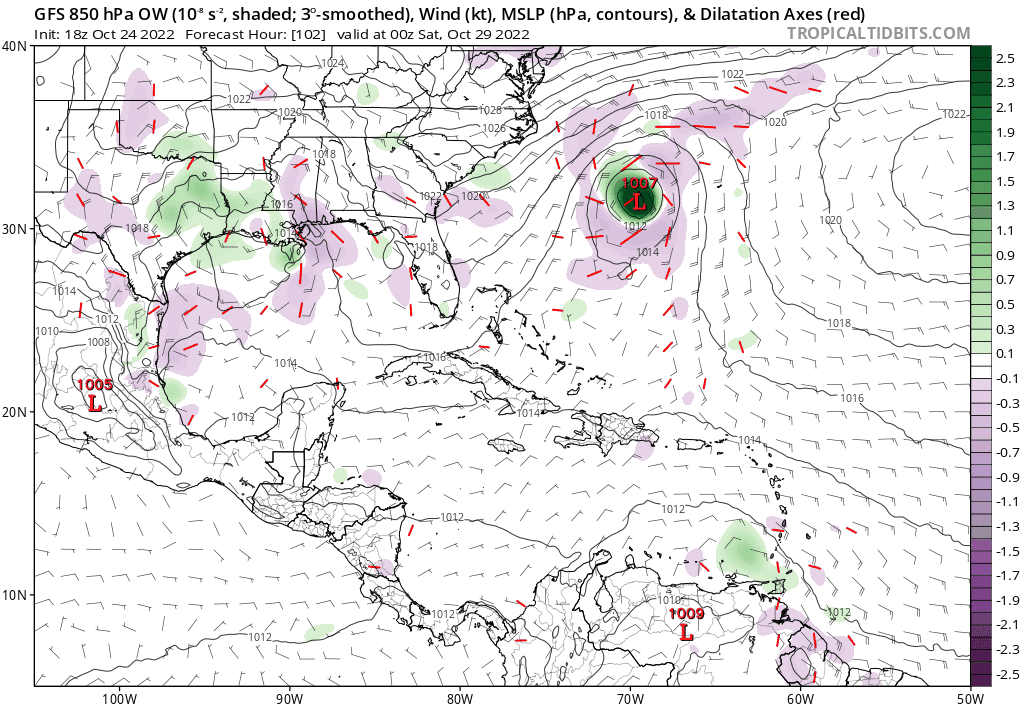
Blown Away wrote:[url]https://i.postimg.cc/gkjhFxTM/gfs-ow850-watl-fh102-384.gif [/url]
18z GFS… Showing a system in the E Caribbean in the 4-5 day range… GFS over past 6+ runs I think has taken out every Caribbean Island, Panhandle, Bahamas, and latest beeline towards FL… Consistently all over the place!
I think we’re starting to see the GFS correct towards a far more likely W/WNW track similar to Julia, since the setup for the two storms seems to be rather similar. The ICON has shown this too.
3 likes
Irene '11 Sandy '12 Hermine '16 5/15/2018 Derecho Fay '20 Isaias '20 Elsa '21 Henri '21 Ida '21
I am only a meteorology enthusiast who knows a decent amount about tropical cyclones. Look to the professional mets, the NHC, or your local weather office for the best information.
I am only a meteorology enthusiast who knows a decent amount about tropical cyclones. Look to the professional mets, the NHC, or your local weather office for the best information.
-
AutoPenalti
- Category 5
- Posts: 4091
- Age: 29
- Joined: Mon Aug 17, 2015 4:16 pm
- Location: Ft. Lauderdale, Florida
Re: 2022 Global Model Runs Discussion (Out thru day 16)
GFS run is fun. Season is not over yet.
1 likes
The posts in this forum are NOT official forecasts and should not be used as such. They are just the opinion of the poster and may or may not be backed by sound meteorological data. They are NOT endorsed by any professional institution or STORM2K. For official information, please refer to products from the NHC and NWS.
Model Runs Cheat Sheet:
GFS (5:30 AM/PM, 11:30 AM/PM)
HWRF, GFDL, UKMET, NAVGEM (6:30-8:00 AM/PM, 12:30-2:00 AM/PM)
ECMWF (1:45 AM/PM)
TCVN is a weighted averaged
-
Hypercane_Kyle
- Category 5
- Posts: 3465
- Joined: Sat Mar 07, 2015 7:58 pm
- Location: Cape Canaveral, FL
Re: 2022 Global Model Runs Discussion (Out thru day 16)
LarryWx wrote:Hypercane_Kyle wrote:Really tough to write the GFS solution as convective feedback as it has consistently advanced the timeline. Remarkably consistent too.
Trust me when I say that it still isn't that tough to write off the GFS, especially when it still has only limited outside support. I've seen the GFS do this kind of thing run after run, including advancing the timeline, and still end up failing. I should clarify and say that whereas I still think the GFS is OTL, I'm not completely writing this off yet.
We'll see. I've watched the inverse play out just as many times (GFS sniffing it out, Euro dropping the ball completely). ICON also has it, FWIW.
0 likes
My posts are my own personal opinion, defer to the National Hurricane Center (NHC) and other NOAA products for decision making during hurricane season.

Re: 2022 Global Model Runs Discussion (Out thru day 16)
If we get Lisa from 94L and this storm were to form after, it would take Martin, the replacement name for Matthew in 2016. That GFS run is uncannily similar to Matthew's path, heading west in the later half of the season, before a turn North and then west through the Bahamas. Not saying it will happen exactly like this, in fact I'm certain it won't! But just a curious similarity between Matthew and his potential successor!
0 likes
Re: 2022 Global Model Runs Discussion (Out thru day 16)
Looks like CMC is back on board with development further west inline with Icon.
0 likes
The following post is NOT an official forecast and should not be used as such. It is just the opinion of the poster and may or may not be backed by sound meteorological data. It is NOT endorsed by any professional institution including storm2k.org For Official Information please refer to the NHC and NWS products.
Who is online
Users browsing this forum: No registered users and 132 guests