2020 Global Model Runs Discussion (Out thru day 16)

This is the general tropical discussion area. Anyone can take their shot at predicting a storms path.

Moderator: S2k Moderators

Forum rules

The posts in this forum are NOT official forecasts and should not be used as such. They are just the opinion of the poster and may or may not be backed by sound meteorological data. They are NOT endorsed by any professional institution or STORM2K. For official information, please refer to products from the National Hurricane Center and National Weather Service.

Help Support Storm2K
Message
Author
User avatar
Spacecoast
Category 2
Category 2
Posts: 758
Joined: Thu Aug 31, 2017 2:03 pm

Re: 2020 Global Model Runs Discussion (Out thru day 16)

#2581 Postby Spacecoast » Wed Sep 23, 2020 6:10 pm

cheezyWXguy wrote:Gradually, I am gaining confidence that this may not be a fluke. Timing is generally remaining consistent, and any deviations occurring appear to be due to southward progression of the front in play. The further the front dives, the earlier and further east the interaction with the tropical wave occurs. A lesser progression allows the wave to travel more west before interaction, resulting in genesis closer to the Yucatán slightly later. This looks more like a depiction of pattern variability than climatological bias to me


Your earlier comment.. I agree
It appears to me that the front is the catalyst for genesis, more so than the strength of the wave. On this run, genesis is spawned at an earlier part of the wave.

That front is very strong, and dives deep. It creates some bigger disturbances in the EPAC soon after.
0 likes   

TheStormExpert

Re: 2020 Global Model Runs Discussion (Out thru day 16)

#2582 Postby TheStormExpert » Wed Sep 23, 2020 6:23 pm

Happy Hour GFS has a strung out mess headed through the FL peninsula.
:na:

I’d be amazed if we don’t see something significant in the Western Caribbean. There’s just so much untapped potential waiting down there assuming conditions are right.
1 likes   

NevadaFan18
Tropical Depression
Tropical Depression
Posts: 51
Joined: Fri Aug 21, 2020 1:51 pm

Re: 2020 Global Model Runs Discussion (Out thru day 16)

#2583 Postby NevadaFan18 » Wed Sep 23, 2020 6:36 pm

TheStormExpert wrote:Happy Hour GFS has a strung out mess headed through the FL peninsula.
:na:

I’d be amazed if we don’t see something significant in the Western Caribbean. There’s just so much untapped potential waiting down there assuming conditions are right.


There's so much time for the UL pattern to change, anything is on the table.
0 likes   

User avatar
MetroMike
Category 4
Category 4
Posts: 952
Joined: Sun Aug 29, 2004 8:13 pm
Location: Tampa Bay
Contact:

Re: 2020 Global Model Runs Discussion (Out thru day 16)

#2584 Postby MetroMike » Wed Sep 23, 2020 6:50 pm

SFLcane wrote:18z GFS Weak shredded mess into FL.

Strength is not so important, it the pattern set-up that is attempting to be resolved at this time.
7 likes   

User avatar
Spacecoast
Category 2
Category 2
Posts: 758
Joined: Thu Aug 31, 2017 2:03 pm

Re: 2020 Global Model Runs Discussion (Out thru day 16)

#2585 Postby Spacecoast » Wed Sep 23, 2020 6:56 pm

18z GEFS (GFS-P):
Wasn't EPAC was supposed to be winding down?
There sure seems to be a lot of EPAC action going on. Too many members to count.
Also, a couple of members heading towards FL. I count maybe 7 members (out of 31).

Image
0 likes   

User avatar
cheezyWXguy
Category 5
Category 5
Posts: 6108
Joined: Mon Feb 13, 2006 12:29 am
Location: Dallas, TX

Re: 2020 Global Model Runs Discussion (Out thru day 16)

#2586 Postby cheezyWXguy » Wed Sep 23, 2020 6:58 pm

Spacecoast wrote:18z GEFS (GFS-P):
Wasn't EPAC was supposed to be winding down?
There sure seems to be a lot of EPAC action going on. Too many members to count.
Also, a couple of members heading towards FL. I count maybe 7 members (out of 31).

https://i.ibb.co/KNvMB3P/gfs-ememb-lowlocs-epac-fh60-282.gif

I think the gfs has forgotten there’s a La Niña going on
5 likes   

User avatar
gatorcane
S2K Supporter
S2K Supporter
Posts: 23691
Age: 47
Joined: Sun Mar 13, 2005 3:54 pm
Location: Boca Raton, FL

Re: 2020 Global Model Runs Discussion (Out thru day 16)

#2587 Postby gatorcane » Wed Sep 23, 2020 7:03 pm

The more interesting thing to me looking at the models is the major cold front both the GFS and Euro show plunging deep into the Gulf and through Florida. :eek: Looks like something you would see in late October or November. The GFS seems to think a lot of shear will be over the NW Carib and Gulf should something decide to move north. Of course we all know how that worked out for Sally but this time the Euro is on board with the massive front as well.

Image
Image
Last edited by gatorcane on Wed Sep 23, 2020 7:07 pm, edited 2 times in total.
3 likes   

User avatar
Steve
S2K Supporter
S2K Supporter
Posts: 9621
Joined: Sat Apr 05, 2003 11:41 pm
Location: Not a state-caster

Re: 2020 Global Model Runs Discussion (Out thru day 16)

#2588 Postby Steve » Wed Sep 23, 2020 7:05 pm

MetroMike wrote:
SFLcane wrote:18z GFS Weak shredded mess into FL.

Strength is not so important, it the pattern set-up that is attempting to be resolved at this time.


Agreed. A big cold high across the south would invite there to be a strengthening system coming up. Idk. I looked at Ventrice’s site, and it looks like rising motion will reach the Caribbean in the period of 10-1 thru 10-7. It goes sort of neutral before that which is an improvement over where we are now (slightly suppressed.
http://www.atmos.albany.edu/student/ven ... _vp200.png

Just the same, we don’t appear to have the kind of MJO signal we had last time a Kelvin Wave brought favorability timed with the MJO moving into 8-1–2. All the global MJO models want to sort of keep it around Phase 5 or 4. There is no strong signal. Obviously those aren’t ideal phases, but they aren’t prohibitive either. Only the NCPE (GFS ensembles) forecasts it toward 8/1. Maybe other models will adjust in time with NCPE, but that’s something to watch over the next 5-7 days. It also should be noted that the GFS ensembles were pretty bad in advance of the last major MJO event. So grain of salt.
https://www.cpc.ncep.noaa.gov/products/ ... r_wh.shtml
4 likes   

User avatar
SFLcane
S2K Supporter
S2K Supporter
Posts: 10163
Age: 47
Joined: Sat Jun 05, 2010 1:44 pm
Location: Lake Worth Florida

Re: 2020 Global Model Runs Discussion (Out thru day 16)

#2589 Postby SFLcane » Wed Sep 23, 2020 7:10 pm

18z GEFS new is still rather active...

Image
3 likes   

User avatar
Steve
S2K Supporter
S2K Supporter
Posts: 9621
Joined: Sat Apr 05, 2003 11:41 pm
Location: Not a state-caster

Re: 2020 Global Model Runs Discussion (Out thru day 16)

#2590 Postby Steve » Wed Sep 23, 2020 7:11 pm

Spacecoast wrote:18z GEFS (GFS-P):
Wasn't EPAC was supposed to be winding down?
There sure seems to be a lot of EPAC action going on. Too many members to count.
Also, a couple of members heading towards FL. I count maybe 7 members (out of 31).

https://i.ibb.co/KNvMB3P/gfs-ememb-lowlocs-epac-fh60-282.gif


In the first link of my prior post, you can see the upward motion moving across the Pacific. If that’s right, no doubt a couple systems could try to spin up in the EPAC over the next week to week and a half.
1 likes   

Nuno
Category 2
Category 2
Posts: 597
Joined: Fri Aug 30, 2019 8:35 am
Location: Coral Gables, FL

Re: 2020 Global Model Runs Discussion (Out thru day 16)

#2591 Postby Nuno » Wed Sep 23, 2020 7:18 pm

wxman57 wrote:
SFLcane wrote:57 what are your thoughts?.. I see you


I'm erecting a barricade across the southern Gulf to prevent hurricane intrusions, similar to my cold air wall on the Canadian border.

Yeah, I've seen the long-range GFS. We typically plan a Disney vacation around the 15th-20th of October (cancelled this year). In almost every year, a hurricane threatens or hits Florida the week before we go. The 12Z GFS may have caught on to the fact that we've cancelled our trip and will remain here in Houston. That's why it is building a ridge over the eastern U.S. and indicating a west Gulf threat instead.

On a more serious note, I think it's indicative that the model is seeing "something" the first week of October in the western Caribbean. It's not uncommon for the GFS to start forecasting development there late season, and it is a prime region for late-season development. Take a look at the 500mb pattern at 240 hrs on the GFS & Euro. Two completely different solutions.

For now, I'll keep an eye on the area but I'm getting to take the rest of the week off and probably next Thu-Fri, too. I think there's a fair chance something may form in the region in early October, but I'm not worrying about it today.


But why do you keep scheduling your vacations during such a risky time for Florida :lol: maybe Disneyland is safer
0 likes   
Andrew (1992), Irene (1999), Frances (2004), Katrina (2005), Wilma (2005), Fay (2008), Irma (2017), Eta (2020), Ian (2022)

Nuno
Category 2
Category 2
Posts: 597
Joined: Fri Aug 30, 2019 8:35 am
Location: Coral Gables, FL

Re: 2020 Global Model Runs Discussion (Out thru day 16)

#2592 Postby Nuno » Wed Sep 23, 2020 7:20 pm

gatorcane wrote:The more interesting thing to me looking at the models is the major cold front both the GFS and Euro show plunging deep into the Gulf and through Florida. :eek: Looks like something you would see in late October or November. The GFS seems to think a lot of shear will be over the NW Carib and Gulf should something decide to move north. Of course we all know how that worked out for Sally but this time the Euro is on board with the massive front as well.

https://i.postimg.cc/t4wSJVcM/gfs-T2ma-us-fh120-240.gif
https://i.postimg.cc/PrczQnML/ecmwf-T850a-us-fh120-240.gif


What about that massive front that was posted here constantly after Laura? It wasn't what the GFS kept predicting.
0 likes   
Andrew (1992), Irene (1999), Frances (2004), Katrina (2005), Wilma (2005), Fay (2008), Irma (2017), Eta (2020), Ian (2022)

User avatar
gatorcane
S2K Supporter
S2K Supporter
Posts: 23691
Age: 47
Joined: Sun Mar 13, 2005 3:54 pm
Location: Boca Raton, FL

Re: 2020 Global Model Runs Discussion (Out thru day 16)

#2593 Postby gatorcane » Wed Sep 23, 2020 7:39 pm

Nuno wrote:
gatorcane wrote:The more interesting thing to me looking at the models is the major cold front both the GFS and Euro show plunging deep into the Gulf and through Florida. :eek: Looks like something you would see in late October or November. The GFS seems to think a lot of shear will be over the NW Carib and Gulf should something decide to move north. Of course we all know how that worked out for Sally but this time the Euro is on board with the massive front as well.

https://i.postimg.cc/t4wSJVcM/gfs-T2ma-us-fh120-240.gif
https://i.postimg.cc/PrczQnML/ecmwf-T850a-us-fh120-240.gif


What about that massive front that was posted here constantly after Laura? It wasn't what the GFS kept predicting.


The GFS was basically alone with the front after Laura, not this time though. Other global models are on board. Seems some kind of front is one the way next week. May not necessarily be a good thing though.
4 likes   

User avatar
SFLcane
S2K Supporter
S2K Supporter
Posts: 10163
Age: 47
Joined: Sat Jun 05, 2010 1:44 pm
Location: Lake Worth Florida

Re: 2020 Global Model Runs Discussion (Out thru day 16)

#2594 Postby SFLcane » Wed Sep 23, 2020 7:42 pm

gatorcane wrote:
Nuno wrote:
gatorcane wrote:The more interesting thing to me looking at the models is the major cold front both the GFS and Euro show plunging deep into the Gulf and through Florida. :eek: Looks like something you would see in late October or November. The GFS seems to think a lot of shear will be over the NW Carib and Gulf should something decide to move north. Of course we all know how that worked out for Sally but this time the Euro is on board with the massive front as well.

https://i.postimg.cc/t4wSJVcM/gfs-T2ma-us-fh120-240.gif
https://i.postimg.cc/PrczQnML/ecmwf-T850a-us-fh120-240.gif


What about that massive front that was posted here constantly after Laura? It wasn't what the GFS kept predicting.


The GFS was basically alone with the front after Laura, not this time though. Other global models are on board. Seems some kind of front is one the way next week. May not necessarily be a good thing though.


With a potential developing TC in the Caribbean that could be our worst enemy.
0 likes   

User avatar
Spacecoast
Category 2
Category 2
Posts: 758
Joined: Thu Aug 31, 2017 2:03 pm

Re: 2020 Global Model Runs Discussion (Out thru day 16)

#2595 Postby Spacecoast » Wed Sep 23, 2020 8:10 pm

21 Hurricanes have crossed the Yucatan Channel during Oct / Nov(all recorded years).
The majority of these (12, or 57%) have hit Florida. Naples, Cape Coral, and Panama City seeem to be climatologically popular.

2018 MICHAEL PANAMA CITY CAT5
2009 IDA PENSACOLA ET
2005 WILMA NAPLES CAT3
1964 ISBELL NAPLES CAT2
1948 UNNAMED KEYS / MIAMI CAT2
1946 UNNAMED TAMPA CAT1
1924 UNNAMED EVERGLADES / MIAMI CAT1
1921 UNNAMED TAMPA CAT3
1910 UNNAMED CAPE CORAL CAT2
1894 UNNAMED PANAMA CITY CAT3
1873 UNNAMED CAPE CORAL CAT3
1852 UNNAMED APALACHICOLA CAT2

Image
Last edited by Spacecoast on Wed Sep 23, 2020 8:16 pm, edited 2 times in total.
1 likes   

ClarCari
Category 2
Category 2
Posts: 579
Joined: Thu Aug 13, 2020 11:02 am

Re: 2020 Global Model Runs Discussion (Out thru day 16)

#2596 Postby ClarCari » Wed Sep 23, 2020 8:14 pm

SFLcane wrote:
gatorcane wrote:
Nuno wrote:
What about that massive front that was posted here constantly after Laura? It wasn't what the GFS kept predicting.


The GFS was basically alone with the front after Laura, not this time though. Other global models are on board. Seems some kind of front is one the way next week. May not necessarily be a good thing though.


With a potential developing TC in the Caribbean that could be our worst enemy.

Our worst enemy because it inhibits TC development or as in it turns it in a more dangerous direction?

I’m curious how much of a “cold” front this will be. Last one was a “warm” front compared to the hot temperatures here in the gulf area. I can’t see this cold front bringing temperatures less 60-65F to most areas.
0 likes   

User avatar
SFLcane
S2K Supporter
S2K Supporter
Posts: 10163
Age: 47
Joined: Sat Jun 05, 2010 1:44 pm
Location: Lake Worth Florida

Re: 2020 Global Model Runs Discussion (Out thru day 16)

#2597 Postby SFLcane » Wed Sep 23, 2020 8:37 pm

ClarCari wrote:
SFLcane wrote:
gatorcane wrote:
The GFS was basically alone with the front after Laura, not this time though. Other global models are on board. Seems some kind of front is one the way next week. May not necessarily be a good thing though.


With a potential developing TC in the Caribbean that could be our worst enemy.

Our worst enemy because it inhibits TC development or as in it turns it in a more dangerous direction?

I’m curious how much of a “cold” front this will be. Last one was a “warm” front compared to the hot temperatures here in the gulf area. I can’t see this cold front bringing temperatures less 60-65F to most areas.


It could prohibit if it digs to deep and increase shear. Can also turn the system northeasterly towards FL. We need a system to develop first
1 likes   


User avatar
Spacecoast
Category 2
Category 2
Posts: 758
Joined: Thu Aug 31, 2017 2:03 pm

Re: 2020 Global Model Runs Discussion (Out thru day 16)

#2599 Postby Spacecoast » Wed Sep 23, 2020 10:37 pm

It looks like the front is real this time.
60% chance of near record minimum temps

Image
Synopsis: A transient mid-level flow pattern is forecast to give way to an amplified pattern over North America prior to week-2.
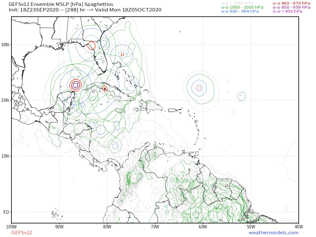
After a recent burst of tropical activity across the Atlantic, much quieter conditions are expected heading into week-2.

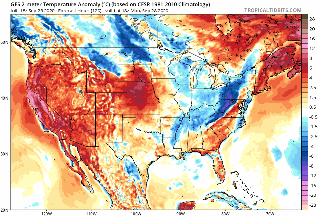
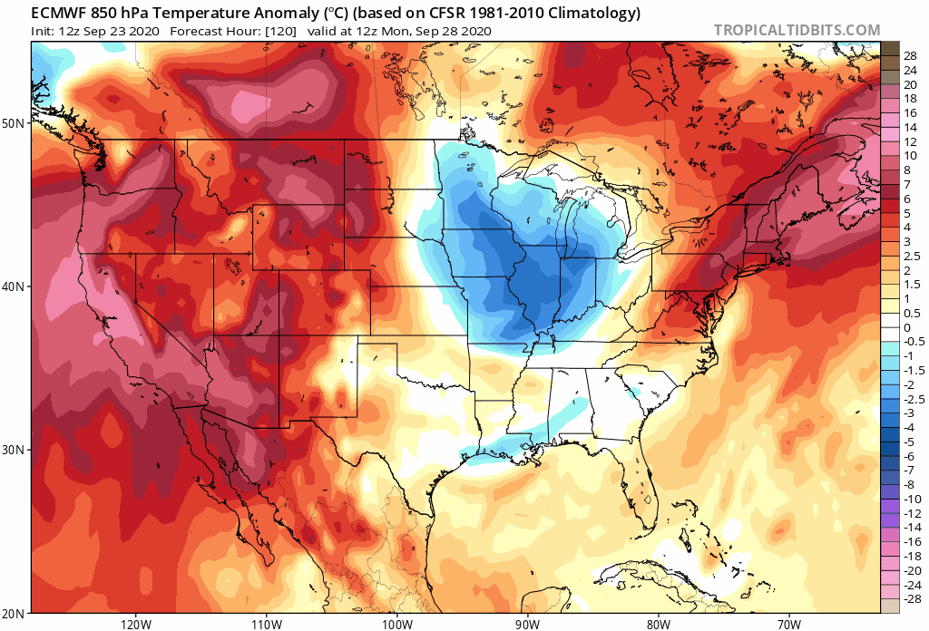
Hazards
High risk (60%) of much below normal temperatures for the vicinity of the Southern and Central Appalachians, Fri-Sat, Oct 2-3.
Moderate risk (40%) of much below normal temperatures over a significant portion of the eastern CONUS, Thu-Mon, Oct 1-5.
Slight risk (20%)of much below normal temperatures over nearly the eastern half of the CONUS, Thu-Tue, Oct 1-6.


As the ridge builds across the western CONUS, downstream troughing is favored to deepen over the eastern states, accompanied by one or two surges of anomalously cold air. Overnight low temperatures are predicted to drop below 40 degrees F throughout most of this region and increase chances for early frost, with the probable exception of near the Gulf Coast. Most of the highlighted areas in the lower latitudes have not yet experienced sufficiently cold temperatures to end the growing season, so vegetation may be vulnerable to the anomalous cold forecast. Places like Mobile and Pensacola, where some residents are still without electrical power after the passage of Hurricane Sally, can expect temperatures to get down to about 40 degrees F. Climatologically, the first freeze of the season near the Gulf Coast comes in early to mid-November. Areas north of a line that extends from about the Ozarks to the Southern Appalachians are likely to experience minimum temperatures near or below freezing during this period. The calibrated ECMWF ensemble predicts a high (60%) chance of near-record minimum temperatures near the Gulf Coast (lowest 1-2% of the historical distribution), while the calibrated GEFS predicts a moderate (50%) chance of minimum temperatures reaching the climatological tenth percentile.
1 likes   

User avatar
Hurricaneman
Category 5
Category 5
Posts: 7351
Age: 45
Joined: Tue Aug 31, 2004 3:24 pm
Location: central florida

Re: 2020 Global Model Runs Discussion (Out thru day 16)

#2600 Postby Hurricaneman » Wed Sep 23, 2020 11:33 pm

seems as though slowly the GFS is trending towards the EPAC with this system
0 likes   


Return to “Talkin' Tropics”

Who is online

Users browsing this forum: Sciencerocks, Steve H. and 31 guests