Possible development in the Western Atlantic / GOM (Is Invest 97L)
Moderator: S2k Moderators
Forum rules

The posts in this forum are NOT official forecasts and should not be used as such. They are just the opinion of the poster and may or may not be backed by sound meteorological data. They are NOT endorsed by any professional institution or STORM2K. For official information, please refer to products from the National Hurricane Center and National Weather Service.
-
Stratton23
- Category 5

- Posts: 3563
- Joined: Fri Jul 21, 2023 10:59 pm
- Location: Katy, Tx
Re: Possible development in the central Atlantic (0/50)
I wouldnt rule out the GFS scenario, especially not a blocking ridge pattern
0 likes
Re: Possible development in the central Atlantic (0/50)
So, at 0Z there’s no consensus of GFS, UKMET, ICON, and CMC although ICON and CMC are very similar.
0 likes
Personal Forecast Disclaimer:
The posts in this forum are NOT official forecasts and should not be used as such. They are just the opinion of the poster and may or may not be backed by sound meteorological data. They are NOT endorsed by any professional institution or storm2k.org. For official information, please refer to the NHC and NWS products.
The posts in this forum are NOT official forecasts and should not be used as such. They are just the opinion of the poster and may or may not be backed by sound meteorological data. They are NOT endorsed by any professional institution or storm2k.org. For official information, please refer to the NHC and NWS products.

Re: Possible development in the central Atlantic (0/50)
The biggest take away from viewing the full gamut of models over the past day or so is a reasonably louder drumbeat in terms of development over all however also clear evidence that the overall picture remains quite murky in terms of where exactly will a true defined COC occur. I still have an eye on the original westward disturbance around 12.5N & 50W and believe that if is a factor in this entire evolution, is apt to occur further south than what the popular consensus is (or where NHC continues to project it to occur).
3 likes
Andy D
(For official information, please refer to the NHC and NWS products.)
(For official information, please refer to the NHC and NWS products.)
Re: Possible development in the central Atlantic (0/50)
Stratton23 wrote:I wouldnt rule out the GFS scenario, especially not a blocking ridge pattern
We just need to see how the upper air pattern looks at that time. Not ruling anything out yet until the models come into better agreement but I do think the Euro solution makes more sense.
0 likes
-
Stratton23
- Category 5
- Posts: 3563
- Joined: Fri Jul 21, 2023 10:59 pm
- Location: Katy, Tx
Re: Possible development in the central Atlantic (0/50)
We will see, its a very complex steering setup, still a range of possibles from the gulf- US, I think a straight path out to sea can be safely ruled out though
0 likes
Re: Possible development in the central Atlantic (0/50)
0Z Euro has a weak low on E coast of FL that moves offshore NE FL and strengthens to 1006 (possible TD) off SC moving toward NC at 240. So, Euro is closer to CMC/ICON than UKMET and nothing like GFS.
0 likes
Personal Forecast Disclaimer:
The posts in this forum are NOT official forecasts and should not be used as such. They are just the opinion of the poster and may or may not be backed by sound meteorological data. They are NOT endorsed by any professional institution or storm2k.org. For official information, please refer to the NHC and NWS products.
The posts in this forum are NOT official forecasts and should not be used as such. They are just the opinion of the poster and may or may not be backed by sound meteorological data. They are NOT endorsed by any professional institution or storm2k.org. For official information, please refer to the NHC and NWS products.
Re: Possible development in the central Atlantic (0/50)
I think the only thing that can truly be ruled out, is Google Bot (see bottom of page dwellers) suddenly becoming sentient and posting his/her own two cents worth on the topic 
(Edit: He clearly heard me, and has since vanished LOLOL)
(Edit: He clearly heard me, and has since vanished LOLOL)
2 likes
Andy D
(For official information, please refer to the NHC and NWS products.)
(For official information, please refer to the NHC and NWS products.)
Re: Possible development in the central Atlantic (0/60)
Tropical Weather Outlook
NWS National Hurricane Center Miami FL
200 AM EDT Tue Jul 30 2024
For the North Atlantic...Caribbean Sea and the Gulf of Mexico:
1. Near the Greater Antilles and the Bahamas:
A large tropical wave centered several hundred miles east of the
Leeward Islands is producing limited shower activity due to dry air
aloft. Environmental conditions are forecast to become more
conducive for development over the warmer waters of the southwestern
Atlantic Ocean during the next day or two, and a tropical depression
could form late this week while the system is in the vicinity of the
Greater Antilles or the Bahamas. Interests in the Greater Antilles,
the Bahamas, and the southeastern U.S. should monitor the progress
of this system.
* Formation chance through 48 hours...low...near 0 percent.
* Formation chance through 7 days...medium...60 percent.
0 likes
Personal Forecast Disclaimer:
The posts in this forum are NOT official forecasts and should not be used as such. They are just the opinion of the poster and may or may not be backed by sound meteorological data. They are NOT endorsed by any professional institution or storm2k.org. For official information, please refer to the NHC and NWS products.
The posts in this forum are NOT official forecasts and should not be used as such. They are just the opinion of the poster and may or may not be backed by sound meteorological data. They are NOT endorsed by any professional institution or storm2k.org. For official information, please refer to the NHC and NWS products.
Re: Possible development in the central Atlantic (0/60)
hmmm, NHC now going 60% Larry? Beginning to feel like "model-casting"  Gonna have to show me the CDO to make me a believer
3 likes
Andy D
(For official information, please refer to the NHC and NWS products.)
(For official information, please refer to the NHC and NWS products.)

-
AtlanticWind

- S2K Supporter

- Posts: 1898
- Age: 67
- Joined: Sun Aug 08, 2004 9:57 pm
- Location: Plantation,Fla
Re: Possible development in the central Atlantic (0/60)
Looks like a pretty strong UKmet run
0 likes
-
Stratton23
- Category 5
- Posts: 3563
- Joined: Fri Jul 21, 2023 10:59 pm
- Location: Katy, Tx
Re: Possible development in the central Atlantic (0/60)
06z GFS, strong blocking high again over the US, forcing the system west bound in the gulf
Last edited by Stratton23 on Tue Jul 30, 2024 5:23 am, edited 1 time in total.
0 likes
-
toad strangler

- S2K Supporter
- Posts: 4546
- Joined: Sun Jul 28, 2013 3:09 pm
- Location: Earth
- Contact:
Re: Possible development in the central Atlantic (0/60)
Looks to me the NHC is hedging on the off the SE coast scenario with the shape of their current graphic (ORANGE). It's weighted more to the east than I've noticed.
Last edited by toad strangler on Tue Jul 30, 2024 5:51 am, edited 1 time in total.
0 likes
My Weather Station
https://www.wunderground.com/dashboard/pws/KFLPORTS603
https://www.wunderground.com/dashboard/pws/KFLPORTS603

Re: Possible development in the central Atlantic (0/60)
Strong Omega Block forecast over mid Conus.
Looking more likely for a GOM TC
Looking more likely for a GOM TC
0 likes
Re: Possible development in the central Atlantic (0/60)
GCANE wrote:Strong Omega Block forecast over mid Conus.
Looking more likely for a GOM TC
Another Omega Block forecast to the west of this one.
A train of Omega Blocks would definitely push any TC west and not recurve
0 likes
-
jlauderdal
- S2K Supporter
- Posts: 7240
- Joined: Wed May 19, 2004 5:46 am
- Location: NE Fort Lauderdale
- Contact:
Re: Possible development in the central Atlantic (0/60)
toad strangler wrote:Looks to me the NHC is hedging on the off the SE coast scenario with the shape of their current graphic (ORANGE). It's weighted more to the east than I've noticed.
Euro has been consistently east so they have to give it weight, gfs has been west and it makes sense too. Remember, the graphic is for formation not track so you can read the tea leaves and more importantly, wait and see how it develops.
0 likes
-
toad strangler
- S2K Supporter
- Posts: 4546
- Joined: Sun Jul 28, 2013 3:09 pm
- Location: Earth
- Contact:
Re: Possible development in the central Atlantic (0/60)
jlauderdal wrote:toad strangler wrote:Looks to me the NHC is hedging on the off the SE coast scenario with the shape of their current graphic (ORANGE). It's weighted more to the east than I've noticed.
Euro has been consistently east so they have to give it weight, gfs has been west and it makes sense too. Remember, the graphic is for formation not track so you can read the tea leaves and more importantly, wait and see how it develops.
I completely understand what the shaded area means. Just commenting that it's been nudged further east. THis is a tough one. There is almost nothing to look at out there.
1 likes
My Weather Station
https://www.wunderground.com/dashboard/pws/KFLPORTS603
https://www.wunderground.com/dashboard/pws/KFLPORTS603

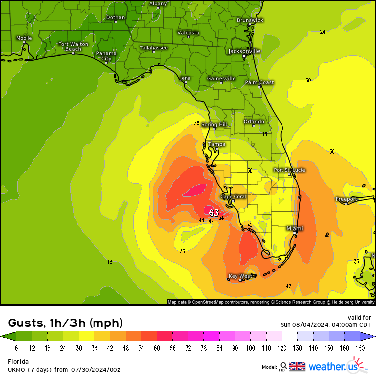
Re: Possible development in the central Atlantic (0/60)
Another look at the 0z UKMET and it’s significant west shift into the Gulf:

Sent from my iPad using Tapatalk
Sent from my iPad using Tapatalk
0 likes
Re: Possible development in the central Atlantic (0/60)
Very large/broad spin on Satellite now, this will take a while to get organized.

Model runs this morning are a real head scratcher though.
Model runs this morning are a real head scratcher though.
1 likes

Re: Possible development in the central Atlantic (0/60)
GCANE wrote:Strong Omega Block forecast over mid Conus.
Looking more likely for a GOM TC
I don’t think the NHC agrees with the omega block looks like they are siding with the Euro,Icon and CMC. At least at the 8am update.
0 likes
Who is online
Users browsing this forum: No registered users and 190 guests