2020 Global Model Runs Discussion (Out thru day 16)
Moderator: S2k Moderators
Forum rules

The posts in this forum are NOT official forecasts and should not be used as such. They are just the opinion of the poster and may or may not be backed by sound meteorological data. They are NOT endorsed by any professional institution or STORM2K. For official information, please refer to products from the National Hurricane Center and National Weather Service.
-
gatorcane

- S2K Supporter

- Posts: 23708
- Age: 48
- Joined: Sun Mar 13, 2005 3:54 pm
- Location: Boca Raton, FL
Re: 2020 Global Model Runs Discussion (Out thru day 16)
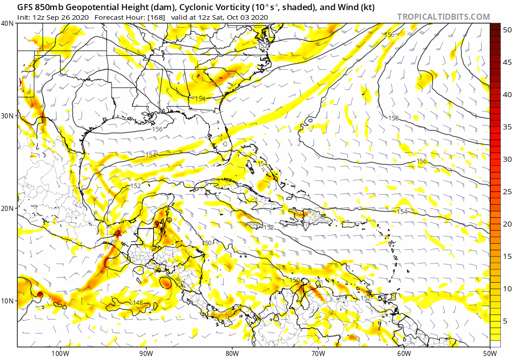
12Z GFS saved loop MUCH weaker and into the Yucatan:
0 likes
-
cheezyWXguy

- Category 5

- Posts: 6282
- Joined: Mon Feb 13, 2006 12:29 am
- Location: Dallas, TX
Re: 2020 Global Model Runs Discussion (Out thru day 16)
Lol. Splits the difference and forms on the Yucatán
2 likes
-
toad strangler

- S2K Supporter
- Posts: 4546
- Joined: Sun Jul 28, 2013 3:09 pm
- Location: Earth
- Contact:
Re: 2020 Global Model Runs Discussion (Out thru day 16)
Spacecoast wrote:cheezyWXguy wrote:Already a different evolution on the 12z gfs through hour 210. We’ll see how this ends up
GFS Trend... Where did it go?
https://i.ibb.co/LQPrctG/gfs-mslp-pcpn-watl-fh234-trend.gif
No such thing as a trend on 10 day maps. Just wild fluctuations due to how far it's out.
1 likes
My Weather Station
https://www.wunderground.com/dashboard/pws/KFLPORTS603
https://www.wunderground.com/dashboard/pws/KFLPORTS603
-
WeatherEmperor
- S2K Supporter
- Posts: 4806
- Age: 42
- Joined: Thu Sep 04, 2003 2:54 pm
- Location: South Florida
Re: 2020 Global Model Runs Discussion (Out thru day 16)
12z Canadian

Sent from my iPhone using Tapatalk
Sent from my iPhone using Tapatalk
0 likes
-
Spacecoast

- Category 2

- Posts: 773
- Joined: Thu Aug 31, 2017 2:03 pm
Re: 2020 Global Model Runs Discussion (Out thru day 16)
toad strangler wrote:Spacecoast wrote:cheezyWXguy wrote:Already a different evolution on the 12z gfs through hour 210. We’ll see how this ends up
GFS Trend... Where did it go?
https://i.ibb.co/LQPrctG/gfs-mslp-pcpn-watl-fh234-trend.gif
No such thing as a trend on 10 day maps. Just wild fluctuations due to how far it's out.
Of course you are correct. I just tagged it that way for clarification, as TT calls it 'forecast trend'.
Perhaps I will start tagging them 'GFS forecast fluctuations'.
CMC seems more consistent.
Last edited by Spacecoast on Sat Sep 26, 2020 11:52 am, edited 1 time in total.
0 likes
-
toad strangler
- S2K Supporter
- Posts: 4546
- Joined: Sun Jul 28, 2013 3:09 pm
- Location: Earth
- Contact:
Re: 2020 Global Model Runs Discussion (Out thru day 16)
Spacecoast wrote:toad strangler wrote:Spacecoast wrote:
GFS Trend... Where did it go?
https://i.ibb.co/LQPrctG/gfs-mslp-pcpn-watl-fh234-trend.gif
No such thing as a trend on 10 day maps. Just wild fluctuations due to how far it's out.
Of course you are correct. I just tagged it that way for clarification, as TT calls it 'forecast trend'.
Perhaps I will start tagging them 'GFS forecast fluctuations'.
I get it, it's just a word. But we all know what that meaning involves. And it's not about 240 hour maps
2 likes
My Weather Station
https://www.wunderground.com/dashboard/pws/KFLPORTS603
https://www.wunderground.com/dashboard/pws/KFLPORTS603
-
toad strangler
- S2K Supporter
- Posts: 4546
- Joined: Sun Jul 28, 2013 3:09 pm
- Location: Earth
- Contact:
Re: 2020 Global Model Runs Discussion (Out thru day 16)
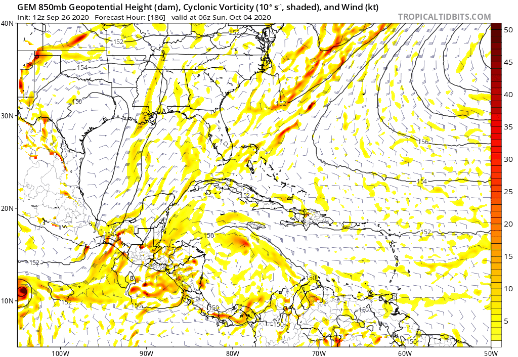
12z CMC with a strengthening cyclone in a precarious position near the middle of the Yucatan CHannel at end of run.
Last edited by toad strangler on Sat Sep 26, 2020 11:54 am, edited 1 time in total.
0 likes
My Weather Station
https://www.wunderground.com/dashboard/pws/KFLPORTS603
https://www.wunderground.com/dashboard/pws/KFLPORTS603
-
cheezyWXguy
- Category 5
- Posts: 6282
- Joined: Mon Feb 13, 2006 12:29 am
- Location: Dallas, TX
Re: 2020 Global Model Runs Discussion (Out thru day 16)
Cmc has been a lot more consistent run to run than the gfs, and is more in line with the last few ensemble runs as well as most of 06z suite. Gfs seems to be having trouble figuring out what it wants to do with any of this
2 likes
-
SFLcane

- S2K Supporter
- Posts: 10281
- Age: 48
- Joined: Sat Jun 05, 2010 1:44 pm
- Location: Lake Worth Florida
Re: 2020 Global Model Runs Discussion (Out thru day 16)
cheezyWXguy wrote:Lol. Splits the difference and forms on the Yucatán
I’d go with GEFS ensembles for now.
2 likes

Re: 2020 Global Model Runs Discussion (Out thru day 16)
toad strangler wrote:12z CMC with a strengthening cyclone in a precarious position near the middle of the Yucatan CHannel at end of run.
That’s almost the point of no return for high risk of a US landfalling storm in October. If a system makes it into that area it’s way more likely than not... a few instances of pronounced hard 90 turns to avoid FL... but not many
0 likes
-
Spacecoast
- Category 2
- Posts: 773
- Joined: Thu Aug 31, 2017 2:03 pm
Re: 2020 Global Model Runs Discussion (Out thru day 16)
SFLcane wrote:

Last 6 hours of CMC run indicate NE turn
sorta like 121 years ago (to the day):
Key West Hurricane of 1909 (October 6 – October 13)

0 likes
-
cheezyWXguy
- Category 5
- Posts: 6282
- Joined: Mon Feb 13, 2006 12:29 am
- Location: Dallas, TX
Re: 2020 Global Model Runs Discussion (Out thru day 16)
If the gefs is to be believed, the potential could be there for back to back majors in the Caribbean. Second one favors Felix 07 as the analog through 234hr. But so much time for things get settled that is purely entertainment
0 likes
-
SFLcane
- S2K Supporter
- Posts: 10281
- Age: 48
- Joined: Sat Jun 05, 2010 1:44 pm
- Location: Lake Worth Florida
Re: 2020 Global Model Runs Discussion (Out thru day 16)
cheezyWXguy wrote:If the gefs is to be believed, the potential could be there for back to back majors in the Caribbean. Second one favors Felix 07 as the analog through 234hr. But so much time for things get settled that is purely entertainment
Id side with gefs ensembles here. The euro has just been horrid this season unfortunately.
https://twitter.com/ericblake12/status/1309896832743596033
0 likes

Re: 2020 Global Model Runs Discussion (Out thru day 16)
12z CMC has a very well-defined wave entering the Caribbean in 5 days. If the precursor wave is this strong, we might have to watch out for development in the eastern half of the Caribbean, several days before it reaches the extra-scorching waters of the WCar and Yucutan Channel.


7 likes
Irene '11 Sandy '12 Hermine '16 5/15/2018 Derecho Fay '20 Isaias '20 Elsa '21 Henri '21 Ida '21
I am only a meteorology enthusiast who knows a decent amount about tropical cyclones. Look to the professional mets, the NHC, or your local weather office for the best information.
I am only a meteorology enthusiast who knows a decent amount about tropical cyclones. Look to the professional mets, the NHC, or your local weather office for the best information.
-
Dean4Storms
- S2K Supporter
- Posts: 6358
- Age: 63
- Joined: Sun Aug 31, 2003 1:01 pm
- Location: Miramar Bch. FL
Re: 2020 Global Model Runs Discussion (Out thru day 16)
Don't know if it got mentioned but the 00z ECM Ensembles are at 20% at 10 days of TC development in the Western Carib.
1 likes
-
SouthFLTropics

- Category 5
- Posts: 4258
- Age: 50
- Joined: Thu Aug 14, 2003 8:04 am
- Location: Port St. Lucie, Florida
Re: 2020 Global Model Runs Discussion (Out thru day 16)
Looks like the 12z Para is going with the BOGO scenario again.
Sent from my iPhone using Tapatalk
Sent from my iPhone using Tapatalk
0 likes
Fourth Generation Florida Native
Personal Storm History: David 79, Andrew 92, Erin 95, Floyd 99, Irene 99, Frances 04, Jeanne 04, Wilma 05, Matthew 16, Irma 17, Ian 22, Nicole 22, Milton 24
Personal Storm History: David 79, Andrew 92, Erin 95, Floyd 99, Irene 99, Frances 04, Jeanne 04, Wilma 05, Matthew 16, Irma 17, Ian 22, Nicole 22, Milton 24
-
toad strangler
- S2K Supporter
- Posts: 4546
- Joined: Sun Jul 28, 2013 3:09 pm
- Location: Earth
- Contact:
Re: 2020 Global Model Runs Discussion (Out thru day 16)
SouthFLTropics wrote:Looks like the 12z Para is going with the BOGO scenario again.
Sent from my iPhone using Tapatalk
Misses the peninsula to the W on 1 and the E on 2
Luck of the Irish
0 likes
My Weather Station
https://www.wunderground.com/dashboard/pws/KFLPORTS603
https://www.wunderground.com/dashboard/pws/KFLPORTS603
Re: 2020 Global Model Runs Discussion (Out thru day 16)
The models are split on what to do with the first wave. Either it’s slightly faster and further south, plowing into Central America (GFS and CMC), or it’s slightly slower and further north, and is able to develop (GFS-Para and ICON). Only the GFS-Para and CMC show the second wave developing as of now.
0 likes
Irene '11 Sandy '12 Hermine '16 5/15/2018 Derecho Fay '20 Isaias '20 Elsa '21 Henri '21 Ida '21
I am only a meteorology enthusiast who knows a decent amount about tropical cyclones. Look to the professional mets, the NHC, or your local weather office for the best information.
I am only a meteorology enthusiast who knows a decent amount about tropical cyclones. Look to the professional mets, the NHC, or your local weather office for the best information.
Who is online
Users browsing this forum: No registered users and 256 guests