Tropical Wave over the SE Bahamas (Is INVEST 91L)

This is the general tropical discussion area. Anyone can take their shot at predicting a storms path.

Moderator: S2k Moderators

Forum rules

The posts in this forum are NOT official forecasts and should not be used as such. They are just the opinion of the poster and may or may not be backed by sound meteorological data. They are NOT endorsed by any professional institution or STORM2K. For official information, please refer to products from the National Hurricane Center and National Weather Service.

Help Support Storm2K
Message
Author
User avatar
SoupBone
Category 5
Category 5
Posts: 3111
Joined: Tue Sep 20, 2005 5:24 pm

Re: Tropical Wave approaching Lesser Antilles

#281 Postby SoupBone » Tue Aug 28, 2018 2:13 pm

wxman57 wrote:
SoupBone wrote:And the GFS says "nahhhh". Does the GFS drop this because it goes over Hispaniola?


There is nothing for Hispaniola to disrupt as it passes. It's simply a tropical wave. There is no core. I wouldn't get too excited about this first modelcane of the season. It may develop, but there's certainly no guarantee of development. Could just bring some rain to the Gulf Coast.


I think you just smack-talked the Euro. Seriously though, appreciate the response. Just don't rain on my Winter thread.
1 likes   
Personal Forecast Disclaimer:
The posts in this forum are NOT official forecast and should not be used as such. They are just the opinion of the poster and may or may not be backed by sound meteorological data. They are NOT endorsed by any professional institution or storm2k.org. For official information, please refer to the NHC and NWS products.

stormlover2013

Re: Tropical Wave approaching Lesser Antilles

#282 Postby stormlover2013 » Tue Aug 28, 2018 2:14 pm

Models have been everywhere, CMC south texas, Euro corpus, euro last 2 runs La, GFS we don't know lol
0 likes   

User avatar
Hypercane_Kyle
Category 5
Category 5
Posts: 3352
Joined: Sat Mar 07, 2015 7:58 pm
Location: Cape Canaveral, FL

Re: Tropical Wave approaching Lesser Antilles

#283 Postby Hypercane_Kyle » Tue Aug 28, 2018 2:15 pm

Ian2401 wrote:Image
I just can't see the Euro's Florida TS verifying given the current upper level conditions.


? That's actually not a terrible upper level environment. Very low shear in the Gulf.
2 likes   
My posts are my own personal opinion, defer to the National Hurricane Center (NHC) and other NOAA products for decision making during hurricane season.

User avatar
SoupBone
Category 5
Category 5
Posts: 3111
Joined: Tue Sep 20, 2005 5:24 pm

Re: Tropical Wave approaching Lesser Antilles

#284 Postby SoupBone » Tue Aug 28, 2018 2:16 pm

stormlover2013 wrote:Models have been everywhere, CMC south texas, Euro corpus, euro last 2 runs La, GFS we don't know lol


Cue the shear map! It's not exactly in an ideal environment right now, or for the next day or so either. :lol:

Image
0 likes   
Personal Forecast Disclaimer:
The posts in this forum are NOT official forecast and should not be used as such. They are just the opinion of the poster and may or may not be backed by sound meteorological data. They are NOT endorsed by any professional institution or storm2k.org. For official information, please refer to the NHC and NWS products.

Ian2401
Category 1
Category 1
Posts: 307
Joined: Thu Sep 14, 2017 5:55 pm
Location: Tallahassee, Florida
Contact:

Re: Tropical Wave approaching Lesser Antilles

#285 Postby Ian2401 » Tue Aug 28, 2018 2:18 pm

Hypercane_Kyle wrote:
Ian2401 wrote:https://i.imgur.com/HTpZZpd.png
I just can't see the Euro's Florida TS verifying given the current upper level conditions.


? That's actually not a terrible upper level environment. Very low shear in the Gulf.

Yes Gulf looks ok, but I was saying that I can't see a strong TS impacting FL like the Euro is saying because the shear is just too high leading up to it
0 likes   
B.S. Meteorology from Florida State '24 // Current M.S. Meteorology student at Florida State

Research Interests: Rapid Intensification, TC Climatology, TC Modeling

Consult the NHC for official information

User avatar
cycloneye
Admin
Admin
Posts: 145282
Age: 68
Joined: Thu Oct 10, 2002 10:54 am
Location: San Juan, Puerto Rico

Re: Tropical Wave approaching Lesser Antilles

#286 Postby cycloneye » Tue Aug 28, 2018 2:18 pm

wxman57 wrote:
SoupBone wrote:And the GFS says "nahhhh". Does the GFS drop this because it goes over Hispaniola?


There is nothing for Hispaniola to disrupt as it passes. It's simply a tropical wave. There is no core. I wouldn't get too excited about this first modelcane of the season. It may develop, but there's certainly no guarantee of development. Could just bring some rain to the Gulf Coast.


We have to wait for more runs to look for consistency.
0 likes   
Visit the Caribbean-Central America Weather Thread where you can find at first post web cams,radars
and observations from Caribbean basin members Click Here

User avatar
SFLcane
S2K Supporter
S2K Supporter
Posts: 10163
Age: 47
Joined: Sat Jun 05, 2010 1:44 pm
Location: Lake Worth Florida

Re: Tropical Wave approaching Lesser Antilles

#287 Postby SFLcane » Tue Aug 28, 2018 2:19 pm

0 likes   

User avatar
mcheer23
Professional-Met
Professional-Met
Posts: 436
Age: 32
Joined: Sun Jun 24, 2012 8:24 pm
Location: Sugar Land, Texas

Re: Tropical Wave approaching Lesser Antilles

#288 Postby mcheer23 » Tue Aug 28, 2018 2:20 pm

The whole gulf coast should just be weather aware. Nothing to worry about right now, may develop... may not.
0 likes   

User avatar
NDG
S2K Supporter
S2K Supporter
Posts: 15446
Joined: Sun Jul 09, 2006 10:14 pm
Location: Orlando, FL

Re: Tropical Wave approaching Lesser Antilles

#289 Postby NDG » Tue Aug 28, 2018 2:22 pm

There's actually higher support by GEFS members compared to the last two runs so don't be surprised if the GFS brings development back on its next run(s).

Image
0 likes   

Wakeknight
Tropical Low
Tropical Low
Posts: 26
Joined: Fri Sep 02, 2016 7:37 am
Location: Nokomis, FL

Re: Tropical Wave approaching Lesser Antilles

#290 Postby Wakeknight » Tue Aug 28, 2018 2:24 pm

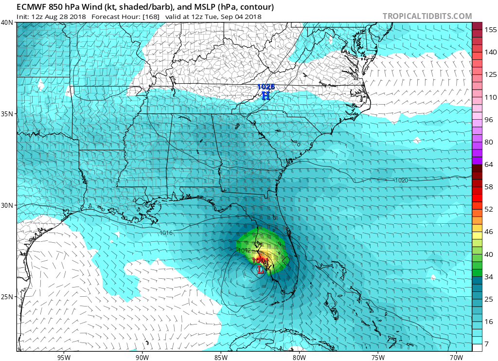
gatorcane wrote:Decent winds for West-Central and SW Florida (note those are at the 850MB level in graphic below). Wonder what this will do to the red-tide along the SW Coast of Florida?

Image


Hopefully it takes the red tide with it. My kids haven't been able to spend much time outside for over a month now...
2 likes   

USTropics
Professional-Met
Professional-Met
Posts: 2649
Joined: Sun Aug 12, 2007 3:45 am
Location: Florida State University

Re: Tropical Wave approaching Lesser Antilles

#291 Postby USTropics » Tue Aug 28, 2018 2:30 pm

The wave axis can be tracked using the 12z ECMWF run, and I've highlighted it below. The difference between the ECMWF and GFS is purely the ECMWF increasing vorticity on the northern flank of the tropical wave axis as it crosses over Hispaniola/DR. The GFS has a less discernible wave axis, and no vort signature in the Bahamas develops (compare 96 hours of the ECMWF to 96 hours of the GFS):

12z ECMWF animation:
Image

12z GFS at 96 hours:
Image
Last edited by USTropics on Tue Aug 28, 2018 3:01 pm, edited 1 time in total.
0 likes   

User avatar
mcheer23
Professional-Met
Professional-Met
Posts: 436
Age: 32
Joined: Sun Jun 24, 2012 8:24 pm
Location: Sugar Land, Texas

Re: Tropical Wave approaching Lesser Antilles

#292 Postby mcheer23 » Tue Aug 28, 2018 2:30 pm

GEPS is quite interesting
1 likes   

stormlover2013

Re: Tropical Wave approaching Lesser Antilles

#293 Postby stormlover2013 » Tue Aug 28, 2018 2:31 pm

mcheer23 wrote:GEPS is quite interesting


why is that?
0 likes   

User avatar
wxman57
Moderator-Pro Met
Moderator-Pro Met
Posts: 22977
Age: 67
Joined: Sat Jun 21, 2003 8:06 pm
Location: Houston, TX (southwest)

Re: Tropical Wave approaching Lesser Antilles

#294 Postby wxman57 » Tue Aug 28, 2018 2:32 pm

Take a look at the TPW loop (below). There is little or no rotation associated with the wave, and TPW isn't extremely high - two strikes against development. In contrast, look a that the wave now emerging off the west coast of Africa. Significant rotation and higher TPW values.

http://tropic.ssec.wisc.edu/real-time/mtpw2/product.php?color_type=tpw_nrl_colors&prod=natl&timespan=72hrs&anim=html5
5 likes   

User avatar
Bocadude85
Category 5
Category 5
Posts: 2991
Age: 38
Joined: Mon Apr 18, 2005 2:20 pm
Location: Honolulu,Hi

Re: Tropical Wave approaching Lesser Antilles

#295 Postby Bocadude85 » Tue Aug 28, 2018 2:41 pm

wxman57 wrote:Take a look at the TPW loop (below). There is little or no rotation associated with the wave, and TPW isn't extremely high - two strikes against development. In contrast, look a that the wave now emerging off the west coast of Africa. Significant rotation and higher TPW values.

http://tropic.ssec.wisc.edu/real-time/mtpw2/product.php?color_type=tpw_nrl_colors&prod=natl&timespan=72hrs&anim=html5


I do not want my Labor Day weekend ruined so hopefully the Euro is full of it.
0 likes   

User avatar
gatorcane
S2K Supporter
S2K Supporter
Posts: 23691
Age: 47
Joined: Sun Mar 13, 2005 3:54 pm
Location: Boca Raton, FL

Re: Tropical Wave approaching Lesser Antilles

#296 Postby gatorcane » Tue Aug 28, 2018 2:47 pm

stormlover2013 wrote:
mcheer23 wrote:GEPS is quite interesting


why is that?


Shows development (some ensembles stronger) in Bahamas (east of Euro) with tracks generally NW = conditions look favorable in the Bahamas:

Image
1 likes   

LarryWx
S2K Supporter
S2K Supporter
Posts: 6302
Joined: Sun Sep 07, 2003 2:04 pm
Location: GA

Re: Tropical Wave approaching Lesser Antilles

#297 Postby LarryWx » Tue Aug 28, 2018 2:48 pm

12Z Euro ensemble (EPS) update: much more active for this than was the 0Z EPS. Something like 30% of the members have a TS+ vs only about 5% on the prior run! Most of these are in the GOM but a couple hit central or N FL east coast. Now this is starting to get my attention a bit more.
Last edited by LarryWx on Tue Aug 28, 2018 2:49 pm, edited 1 time in total.
1 likes   
Personal Forecast Disclaimer:
The posts in this forum are NOT official forecasts and should not be used as such. They are just the opinion of the poster and may or may not be backed by sound meteorological data. They are NOT endorsed by any professional institution or storm2k.org. For official information, please refer to the NHC and NWS products.

User avatar
NDG
S2K Supporter
S2K Supporter
Posts: 15446
Joined: Sun Jul 09, 2006 10:14 pm
Location: Orlando, FL

Re: Tropical Wave approaching Lesser Antilles

#298 Postby NDG » Tue Aug 28, 2018 2:48 pm

wxman57 wrote:Take a look at the TPW loop (below). There is little or no rotation associated with the wave, and TPW isn't extremely high - two strikes against development. In contrast, look a that the wave now emerging off the west coast of Africa. Significant rotation and higher TPW values.

http://tropic.ssec.wisc.edu/real-time/mtpw2/product.php?color_type=tpw_nrl_colors&prod=natl&timespan=72hrs&anim=html5


But this TW is going to be moving into some of the warmest waters of the Atlantic Basin and a more moist environment, contrary to the TW just emerging off of Africa.
0 likes   

User avatar
toad strangler
S2K Supporter
S2K Supporter
Posts: 4543
Joined: Sun Jul 28, 2013 3:09 pm
Location: Earth
Contact:

Re: Tropical Wave approaching Lesser Antilles

#299 Postby toad strangler » Tue Aug 28, 2018 2:48 pm

Bocadude85 wrote:
wxman57 wrote:Take a look at the TPW loop (below). There is little or no rotation associated with the wave, and TPW isn't extremely high - two strikes against development. In contrast, look a that the wave now emerging off the west coast of Africa. Significant rotation and higher TPW values.

http://tropic.ssec.wisc.edu/real-time/mtpw2/product.php?color_type=tpw_nrl_colors&prod=natl&timespan=72hrs&anim=html5


I do not want my Labor Day weekend ruined so hopefully the Euro is full of it.


This would MAKE my Labor Day weekend :Partytime: Bring It
Last edited by toad strangler on Tue Aug 28, 2018 3:59 pm, edited 2 times in total.
0 likes   

User avatar
Cpv17
Category 5
Category 5
Posts: 4975
Joined: Wed Dec 07, 2016 2:24 pm
Location: Wharton/El Campo, TX

Re: Tropical Wave approaching Lesser Antilles

#300 Postby Cpv17 » Tue Aug 28, 2018 2:52 pm

Judging by the latest 6-10 day precipitation forecast from the CPC, they seem to think this wave will move towards the central or south Texas coast vs Louisiana.
1 likes   


Return to “Talkin' Tropics”

Who is online

Users browsing this forum: jgh and 19 guests