2020 WPAC Season

This is the general tropical discussion area. Anyone can take their shot at predicting a storms path.

Moderator: S2k Moderators

Forum rules

The posts in this forum are NOT official forecasts and should not be used as such. They are just the opinion of the poster and may or may not be backed by sound meteorological data. They are NOT endorsed by any professional institution or STORM2K. For official information, please refer to products from the National Hurricane Center and National Weather Service.

Help Support Storm2K
Message
Author
euro6208

Re: 2020 WPAC Season

#281 Postby euro6208 » Thu Aug 27, 2020 6:23 am

EURO pretty robust on Haishen.

12Z

Image
Image

00Z

Image
0 likes   

euro6208

Re: 2020 WPAC Season

#282 Postby euro6208 » Thu Aug 27, 2020 6:36 am

Unlike EURO, GFS keeps it weak.

Image
0 likes   

euro6208

Re: 2020 WPAC Season

#283 Postby euro6208 » Thu Aug 27, 2020 9:33 am

Image
0 likes   

euro6208

Re: 2020 WPAC Season

#284 Postby euro6208 » Thu Aug 27, 2020 9:38 am

Wow no break.

Positive, Negative, and Neutral ENSO, the world's most active basin continues to spew out tropical cyclones affecting coastlines.
0 likes   

euro6208

Re: 2020 WPAC Season

#285 Postby euro6208 » Fri Aug 28, 2020 7:33 am

Absolute insanity right now. 9 days apart.

Image
Image
0 likes   

euro6208

Re: 2020 WPAC Season

#286 Postby euro6208 » Fri Aug 28, 2020 8:36 am

Image

Could be quite an active September.
Last edited by euro6208 on Fri Aug 28, 2020 8:50 am, edited 1 time in total.
0 likes   

User avatar
aspen
Category 5
Category 5
Posts: 8818
Joined: Sat Oct 12, 2019 7:10 pm
Location: Connecticut, USA

Re: 2020 WPAC Season

#287 Postby aspen » Fri Aug 28, 2020 8:44 am

euro6208 wrote:https://i.imgur.com/MHrjrcP.jpg

Could be quite an active September.

Judging by that graphic, it looks like activity in the Atlantic (and the AEW train) will remain above-average until the positive MJO departs from Africa/WIO in mid September. Week 3 could be when the Atlantic “quiets down” (it’ll probably still be active) and the WPac has the opportunity to go berserk.
0 likes   
Irene '11 Sandy '12 Hermine '16 5/15/2018 Derecho Fay '20 Isaias '20 Elsa '21 Henri '21 Ida '21

I am only a meteorology enthusiast who knows a decent amount about tropical cyclones. Look to the professional mets, the NHC, or your local weather office for the best information.

euro6208

Re: 2020 WPAC Season

#288 Postby euro6208 » Fri Aug 28, 2020 8:50 am

0 likes   

euro6208

Re: 2020 WPAC Season

#289 Postby euro6208 » Fri Aug 28, 2020 8:52 am

Strongest run yet. Seems like Mother Nature is mad at Japan and the Koreas.

Image
Image
0 likes   

euro6208

Re: 2020 WPAC Season

#290 Postby euro6208 » Fri Aug 28, 2020 9:03 am

GFS much tamer.

Image
0 likes   

euro6208

Re: 2020 WPAC Season

#291 Postby euro6208 » Fri Aug 28, 2020 9:04 am

GFS has a few more systems after Haishen.
0 likes   

User avatar
aspen
Category 5
Category 5
Posts: 8818
Joined: Sat Oct 12, 2019 7:10 pm
Location: Connecticut, USA

Re: 2020 WPAC Season

#292 Postby aspen » Fri Aug 28, 2020 9:08 am

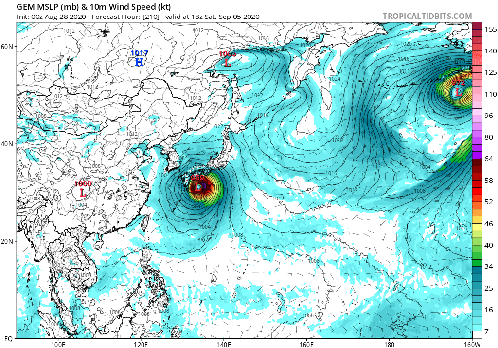
euro6208 wrote:Strongest run yet. Seems like Mother Nature is mad at Japan and the Koreas.

https://i.imgur.com/v7UglFa.png
https://i.imgur.com/y396umr.png

This is a really odd situation the models are agreeing on. The Euro, CMC, and NAVGEM show a disturbance moving south from Japan that develop between 4-6 days, bombs out into a major, and moves back north. ICON shows weak development by 120 hours out, and the GFS shows this developing after 160 hours.
0 likes   
Irene '11 Sandy '12 Hermine '16 5/15/2018 Derecho Fay '20 Isaias '20 Elsa '21 Henri '21 Ida '21

I am only a meteorology enthusiast who knows a decent amount about tropical cyclones. Look to the professional mets, the NHC, or your local weather office for the best information.

euro6208

Re: 2020 WPAC Season

#293 Postby euro6208 » Fri Aug 28, 2020 9:18 am

NAVGEM

Image
0 likes   

User avatar
gatorcane
S2K Supporter
S2K Supporter
Posts: 23691
Age: 47
Joined: Sun Mar 13, 2005 3:54 pm
Location: Boca Raton, FL

Re: 2020 WPAC Season

#294 Postby gatorcane » Fri Aug 28, 2020 10:30 am

CMC is aggressive:

Image
0 likes   

euro6208

Re: 2020 WPAC Season

#295 Postby euro6208 » Fri Aug 28, 2020 11:42 am

Now this is going to put down the ACE for the WPAC. Agencies and estimates are really lagging.

How is this only 35 knots for Maysak?

Where's recon?

Image
0 likes   

User avatar
aspen
Category 5
Category 5
Posts: 8818
Joined: Sat Oct 12, 2019 7:10 pm
Location: Connecticut, USA

Re: 2020 WPAC Season

#296 Postby aspen » Fri Aug 28, 2020 11:57 am

euro6208 wrote:Now this is going to put down the ACE for the WPAC. Agencies and estimates are really lagging.

How is this only 35 knots for Maysak?

Where's recon?

https://i.imgur.com/XFtUWeV.gif

This is currently no more than a moderate TS. While convection is absurdly deep and sign that it could bomb out eventually (similar to Halong and Amphan), it’s somewhat sheared and mainly on the western side of the CoC.
4 likes   
Irene '11 Sandy '12 Hermine '16 5/15/2018 Derecho Fay '20 Isaias '20 Elsa '21 Henri '21 Ida '21

I am only a meteorology enthusiast who knows a decent amount about tropical cyclones. Look to the professional mets, the NHC, or your local weather office for the best information.

euro6208

Re: 2020 WPAC Season

#297 Postby euro6208 » Fri Aug 28, 2020 12:05 pm

aspen wrote:
euro6208 wrote:Now this is going to put down the ACE for the WPAC. Agencies and estimates are really lagging.

How is this only 35 knots for Maysak?

Where's recon?

https://i.imgur.com/XFtUWeV.gif

This is currently no more than a moderate TS. While convection is absurdly deep and sign that it could bomb out eventually (similar to Halong and Amphan), it’s somewhat sheared and mainly on the western side of the CoC.


:D Good answer. :wink:
0 likes   

User avatar
Hayabusa
Category 5
Category 5
Posts: 4350
Joined: Sun Sep 16, 2018 1:05 pm

Re: 2020 WPAC Season

#298 Postby Hayabusa » Fri Aug 28, 2020 2:36 pm

NAVGEM :lol:

Image
0 likes   
ヤンデレ女が寝取られるているのを見たい!!!
ECMWF ensemble NWPAC plots: https://ecmwfensnwpac.imgbb.com/
Multimodel NWPAC plots: https://multimodelnwpac.imgbb.com/
GFS Ensemble NWPAC plots (16 & 35 day forecast): https://gefsnwpac.imgbb.com/
Plots updated automatically

dexterlabio
Category 5
Category 5
Posts: 3468
Joined: Sat Oct 24, 2009 11:50 pm

Re: 2020 WPAC Season

#299 Postby dexterlabio » Fri Aug 28, 2020 8:38 pm

aspen wrote:
euro6208 wrote:https://i.imgur.com/MHrjrcP.jpg

Could be quite an active September.

Judging by that graphic, it looks like activity in the Atlantic (and the AEW train) will remain above-average until the positive MJO departs from Africa/WIO in mid September. Week 3 could be when the Atlantic “quiets down” (it’ll probably still be active) and the WPac has the opportunity to go berserk.


This MJO thing is making me quite puzzled out, at this point in time the unfavorable phase of the MJO is over the WPAC. Yet we were still able to have Bavi, then now Maysak, plus another potential howler in the next 7 days.

Although judging from the development (or future development) of these systems, they did not form in the deep tropics (lower latitude and farther east in the WPAC). So I have a theory that the MJO promotes formation of TCs in the deep tropics, but even without it, typhoons in much higher latitudes and west of 130E longitude can still form.
0 likes   
Personal Forecast Disclaimer:
The posts in this forum are NOT official forecast and should not be used as such. They are just the opinion of the poster and may or may not be backed by sound meteorological data. They are NOT endorsed by any professional institution or storm2k.org. For official information, please refer to the NHC and NWS products.

User avatar
mrbagyo
Category 5
Category 5
Posts: 3717
Age: 33
Joined: Thu Apr 12, 2012 9:18 am
Location: 14.13N 120.98E
Contact:

Re: 2020 WPAC Season

#300 Postby mrbagyo » Sat Aug 29, 2020 3:33 am

Image
Image
Image
0 likes   
The posts in this forum are NOT official forecast and should not be used as such. They are just the opinion of the poster and may or may not be backed by sound meteorological data. They are NOT endorsed by any professional institution or storm2k.org. For official information, please refer to RSMC, NHC and NWS products.


Return to “Talkin' Tropics”

Who is online

Users browsing this forum: Javlin, Kennethb and 48 guests