
2026 ENSO Updates
Moderator: S2k Moderators
Forum rules

The posts in this forum are NOT official forecasts and should not be used as such. They are just the opinion of the poster and may or may not be backed by sound meteorological data. They are NOT endorsed by any professional institution or STORM2K. For official information, please refer to products from the National Hurricane Center and National Weather Service.
-
cycloneye

- Admin

- Posts: 149275
- Age: 69
- Joined: Thu Oct 10, 2002 10:54 am
- Location: San Juan, Puerto Rico
Re: 2026 ENSO Updates
NMME March run is up and has a strong El Niño by June.
0 likes
Visit the Caribbean-Central America Weather Thread where you can find at first post web cams,radars
and observations from Caribbean basin members Click Here
and observations from Caribbean basin members Click Here
-
dexterlabio
- Category 5

- Posts: 3503
- Joined: Sat Oct 24, 2009 11:50 pm
Re: 2026 ENSO Updates
Based on what we're seeing here it looks to me that a strong El Niño appearing sometime this year is a sealed deal. However, the state of PDO and PMM is still quite unclear for this year. It looks like it would take some months to see the stubborn Northern Pacific Ocean warmth to cool down to get that horse shoe +PDO signature. There may be a chance that we see another -PDO/+ENSO in 2026 like what we saw in 2023, but the difference is that the atmosphere might be putting in some effort to flip it to positive.
0 likes
Personal Forecast Disclaimer:
The posts in this forum are NOT official forecast and should not be used as such. They are just the opinion of the poster and may or may not be backed by sound meteorological data. They are NOT endorsed by any professional institution or storm2k.org. For official information, please refer to the NHC and NWS products.
The posts in this forum are NOT official forecast and should not be used as such. They are just the opinion of the poster and may or may not be backed by sound meteorological data. They are NOT endorsed by any professional institution or storm2k.org. For official information, please refer to the NHC and NWS products.
-
xtyphooncyclonex

- Category 5
- Posts: 3891
- Age: 24
- Joined: Sat Dec 08, 2012 9:07 am
- Location: Cebu City
- Contact:
Re: 2026 ENSO Updates
The setup is looking more and more like a strong El Niño. Biggest difference vs 2023 may be a more responsive atmosphere and a more +PMM. PDO may be stubbornly negative because of the warm pool over Japan and the WPac.
I'm most interested to see how this bodes for the WPac. 2023 gave us an absolute low storm count, but 1997-esque ACE per storm.
Any analogs for a +PMM/-PDO?
I'm most interested to see how this bodes for the WPac. 2023 gave us an absolute low storm count, but 1997-esque ACE per storm.
Any analogs for a +PMM/-PDO?
0 likes
REMINDER: My opinions that I, or any other NON Pro-Met in this forum, are unofficial. Please do not take my opinions as an official forecast and warning. I am NOT a meteorologist. Following my forecasts blindly may lead to false alarm, danger and risk if official forecasts from agencies are ignored.
-
Kingarabian

- S2K Supporter

- Posts: 16348
- Joined: Sat Aug 08, 2009 3:06 am
- Location: Honolulu, Hawaii
Re: 2026 ENSO Updates
Trending weaker again. Makes sense since there's no big WPAC MJO.
0 likes
RIP Kobe Bryant
-
DorkyMcDorkface

- Category 4

- Posts: 988
- Age: 28
- Joined: Mon Sep 30, 2019 1:32 pm
- Location: Mid-Atlantic
Re: 2026 ENSO Updates
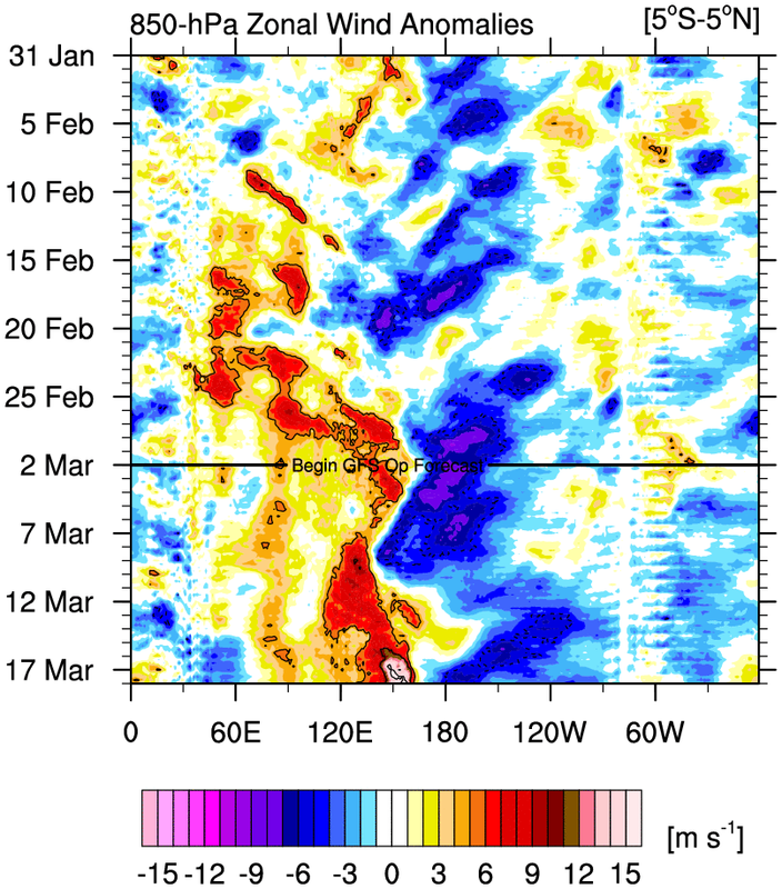
Kingarabian wrote:
https://i.postimg.cc/sDYphgfw/u-anom-30-5S-5N.gif
Trending weaker again. Makes sense since there's no big WPAC MJO.
I know we haven't had a true major WWB centered around the dateline/equatorial CPAC in over a month but it's hard not to believe the expansive subsurface anoms won' t eventually break through even with a period of modestly relaxed trades.
With that being said, despite the lack of MJO support in the WPAC in the short term we would normally see leading up to a WWB akin to the late January one which helped set in motion the strong downwelling KW that is leading us on the path to El Niño, it appears the EPS is very gung-ho on a prolonged one persisting throughout the duration of the month. Looks almost like the beginnings of a Niño standing wave to me?

1 likes
Please note the thougths expressed by this account are solely those of the user and are from a hobbyist perspective. For more comprehensive analysis, consult an actual professional meteorologist or meteorology agency.
Floyd 1999 | Isabel 2003 | Hanna 2008 | Irene 2011 | Sandy 2012 | Isaias 2020
-
cycloneye
- Admin
- Posts: 149275
- Age: 69
- Joined: Thu Oct 10, 2002 10:54 am
- Location: San Juan, Puerto Rico
Re: 2026 ENSO Updates
This is the latest from the subsurface and the blues near the surface are almost gone.

1 likes
Visit the Caribbean-Central America Weather Thread where you can find at first post web cams,radars
and observations from Caribbean basin members Click Here
and observations from Caribbean basin members Click Here
-
mixedDanilo.E
- Tropical Storm

- Posts: 105
- Joined: Sun Nov 21, 2021 8:00 am
- Location: NY
Re: 2026 ENSO Updates
I'm noticing something interesting, and I've been tracking this for the past several days and even weeks at this point, but the EPS seems to show the WWBs in the western pacific pretty decently, but it is struggling to propagate eastward and I especially don't see the strong signal for a basin wide event right now. This now lasts into the first week of April too pretty much since that is how far out the EPS currently goes. Is this because the model is not detecting any WWB's that may be occurring further east right now because we need to move up in time in order to see it, or is there something in the background state that is preventing WWB's right now? Or, is this supposed to happen with El Nino development and WWB's that are basin wide don't come til later?
0 likes
-
DorkyMcDorkface
- Category 4
- Posts: 988
- Age: 28
- Joined: Mon Sep 30, 2019 1:32 pm
- Location: Mid-Atlantic
Re: 2026 ENSO Updates
Comparing seasonal guidance, the CanSIPS is alone in depicting both a (moderate) CPAC-based Niño and a definitive -PDO signature persisting (even with +PMM). This may be partially why it doesn't make the Atlantic season a complete wash. But as of right now nothing else really shows this being the case. That's obviously not to say it won't happen, but it appears to be an outlier for now. Need to watch and see if anything over the next month or two lends credence to this idea given Spring Predictability barrier and all.


0 likes
Please note the thougths expressed by this account are solely those of the user and are from a hobbyist perspective. For more comprehensive analysis, consult an actual professional meteorologist or meteorology agency.
Floyd 1999 | Isabel 2003 | Hanna 2008 | Irene 2011 | Sandy 2012 | Isaias 2020
-
Kingarabian
- S2K Supporter
- Posts: 16348
- Joined: Sat Aug 08, 2009 3:06 am
- Location: Honolulu, Hawaii
Re: 2026 ENSO Updates
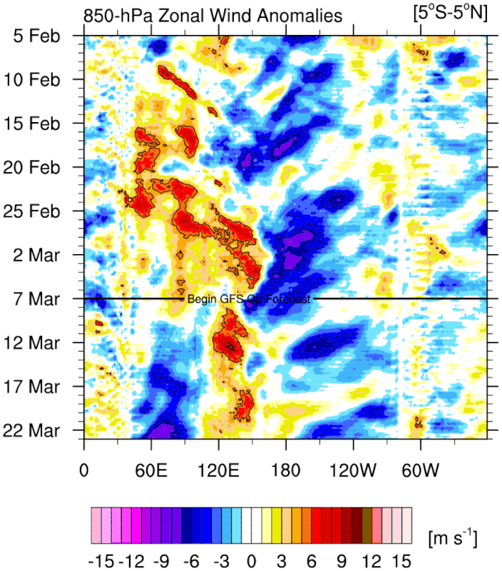
DorkyMcDorkface wrote:Kingarabian wrote:
https://i.postimg.cc/sDYphgfw/u-anom-30-5S-5N.gif
Trending weaker again. Makes sense since there's no big WPAC MJO.
I know we haven't had a true major WWB centered around the dateline/equatorial CPAC in over a month but it's hard not to believe the expansive subsurface anoms won' t eventually break through even with a period of modestly relaxed trades.
With that being said, despite the lack of MJO support in the WPAC in the short term we would normally see leading up to a WWB akin to the late January one which helped set in motion the strong downwelling KW that is leading us on the path to El Niño, it appears the EPS is very gung-ho on a prolonged one persisting throughout the duration of the month. Looks almost like the beginnings of a Niño standing wave to me?
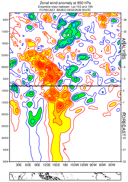
https://i.imgur.com/01vvlHh.png
My only issue with that graphic is that its for 850mb winds at 15N/15S. While the ENSO regions are confined to 5N/5S. This same EPS data has overdone WWBs in the past as well as the December event.
I think El Nino is inevitable but 2014 is a prime example of a significant warm pool in the spring that failed to trigger a JJA El Nino and instead, it came on in the fall as a weak event.
3 likes
RIP Kobe Bryant
-
DorkyMcDorkface
- Category 4
- Posts: 988
- Age: 28
- Joined: Mon Sep 30, 2019 1:32 pm
- Location: Mid-Atlantic
Re: 2026 ENSO Updates
Kingarabian wrote:DorkyMcDorkface wrote:Kingarabian wrote:https://i.postimg.cc/sDYphgfw/u-anom-30-5S-5N.gif
Trending weaker again. Makes sense since there's no big WPAC MJO.
I know we haven't had a true major WWB centered around the dateline/equatorial CPAC in over a month but it's hard not to believe the expansive subsurface anoms won' t eventually break through even with a period of modestly relaxed trades.
With that being said, despite the lack of MJO support in the WPAC in the short term we would normally see leading up to a WWB akin to the late January one which helped set in motion the strong downwelling KW that is leading us on the path to El Niño, it appears the EPS is very gung-ho on a prolonged one persisting throughout the duration of the month. Looks almost like the beginnings of a Niño standing wave to me?
https://i.imgur.com/01vvlHh.png
My only issue with that graphic is that its for 850mb winds at 15N/15S. While the ENSO regions are confined to 5N/5S. This same EPS data has overdone WWBs in the past as well as the December event.
I think El Nino is inevitable but 2014 is a prime example of a significant warm pool in the spring that failed to trigger a JJA El Nino and instead, it came on in the fall as a weak event.
Very true about 2014, I suppose a fail mode like that is still on the table (again, pre-SPB should always be considered). And of course, 2014-15 sputtering ultimately set us up for the Super Niño in 2015-16.
Subsurace comparison between then and now for the heck of it:

2 likes
Please note the thougths expressed by this account are solely those of the user and are from a hobbyist perspective. For more comprehensive analysis, consult an actual professional meteorologist or meteorology agency.
Floyd 1999 | Isabel 2003 | Hanna 2008 | Irene 2011 | Sandy 2012 | Isaias 2020
-
mixedDanilo.E
- Tropical Storm
- Posts: 105
- Joined: Sun Nov 21, 2021 8:00 am
- Location: NY
Re: 2026 ENSO Updates
DorkyMcDorkface wrote:Kingarabian wrote:DorkyMcDorkface wrote:I know we haven't had a true major WWB centered around the dateline/equatorial CPAC in over a month but it's hard not to believe the expansive subsurface anoms won' t eventually break through even with a period of modestly relaxed trades.
With that being said, despite the lack of MJO support in the WPAC in the short term we would normally see leading up to a WWB akin to the late January one which helped set in motion the strong downwelling KW that is leading us on the path to El Niño, it appears the EPS is very gung-ho on a prolonged one persisting throughout the duration of the month. Looks almost like the beginnings of a Niño standing wave to me?
https://i.imgur.com/01vvlHh.png
My only issue with that graphic is that its for 850mb winds at 15N/15S. While the ENSO regions are confined to 5N/5S. This same EPS data has overdone WWBs in the past as well as the December event.
I think El Nino is inevitable but 2014 is a prime example of a significant warm pool in the spring that failed to trigger a JJA El Nino and instead, it came on in the fall as a weak event.
Very true about 2014, I suppose a fail mode like that is still on the table (again, pre-SPB should always be considered). And of course, 2014-15 sputtering ultimately set us up for the Super Niño in 2015-16.
Subsurace comparison between then and now for the heck of it:
https://i.imgur.com/QyT4ahL.png
Oh damn I did not realize the warm pool in 2014 was THAT massive...
0 likes
-
dexterlabio
- Category 5
- Posts: 3503
- Joined: Sat Oct 24, 2009 11:50 pm
Re: 2026 ENSO Updates
While 2014 was a weak El Niño, it felt very El Niño-like for both the WPAC and EPAC that year. Also if I remember correctly that year saw the transition from negative to positive PDO. It set the stage perfectly for the 2015 Super El Niño.
1 likes
Personal Forecast Disclaimer:
The posts in this forum are NOT official forecast and should not be used as such. They are just the opinion of the poster and may or may not be backed by sound meteorological data. They are NOT endorsed by any professional institution or storm2k.org. For official information, please refer to the NHC and NWS products.
The posts in this forum are NOT official forecast and should not be used as such. They are just the opinion of the poster and may or may not be backed by sound meteorological data. They are NOT endorsed by any professional institution or storm2k.org. For official information, please refer to the NHC and NWS products.
-
cycloneye
- Admin
- Posts: 149275
- Age: 69
- Joined: Thu Oct 10, 2002 10:54 am
- Location: San Juan, Puerto Rico
Re: 2026 ENSO Updates
CPC weekly update of 3/9/26 has Niño 3.4 at -0.5C.
https://www.cpc.ncep.noaa.gov/products/ ... ts-web.pdf

https://www.cpc.ncep.noaa.gov/products/ ... ts-web.pdf
0 likes
Visit the Caribbean-Central America Weather Thread where you can find at first post web cams,radars
and observations from Caribbean basin members Click Here
and observations from Caribbean basin members Click Here
-
cycloneye
- Admin
- Posts: 149275
- Age: 69
- Joined: Thu Oct 10, 2002 10:54 am
- Location: San Juan, Puerto Rico
Re: 2026 ENSO Updates
Interesting and informative thread from Dr Ben Noll.
https://x.com/BenNollWeather/status/2030983459708252291
https://x.com/BenNollWeather/status/2030983468562403418
https://x.com/BenNollWeather/status/2030983472144367855
https://x.com/BenNollWeather/status/2030983475629826120
https://x.com/BenNollWeather/status/2030983459708252291
https://x.com/BenNollWeather/status/2030983468562403418
https://x.com/BenNollWeather/status/2030983472144367855
https://x.com/BenNollWeather/status/2030983475629826120
0 likes
Visit the Caribbean-Central America Weather Thread where you can find at first post web cams,radars
and observations from Caribbean basin members Click Here
and observations from Caribbean basin members Click Here
Who is online
Users browsing this forum: Bing [Bot] and 131 guests