2023 Indicators (SST, SAL, MSLP, Wind shear, Steering, Instability) and Day 16+ Models

This is the general tropical discussion area. Anyone can take their shot at predicting a storms path.

Moderator: S2k Moderators

Forum rules

The posts in this forum are NOT official forecasts and should not be used as such. They are just the opinion of the poster and may or may not be backed by sound meteorological data. They are NOT endorsed by any professional institution or STORM2K. For official information, please refer to products from the National Hurricane Center and National Weather Service.

Help Support Storm2K
Message
Author
User avatar
JetFuel_SE
Category 1
Category 1
Posts: 276
Age: 24
Joined: Thu Apr 30, 2020 3:57 pm

Re: 2023 Indicators (SST, SAL, MSLP, Wind shear, Steering, Instability) and Day 16+ Models

#301 Postby JetFuel_SE » Fri May 05, 2023 8:01 am

zzzh wrote:https://i.imgur.com/Bg6ZVMZ.png
EC monthlies forecast an active Atlantic.

Yeah idk about that one.
2 likes   

User avatar
Category5Kaiju
Category 5
Category 5
Posts: 3404
Age: 22
Joined: Thu Dec 24, 2020 12:45 pm
Location: Seattle

Re: 2023 Indicators (SST, SAL, MSLP, Wind shear, Steering, Instability) and Day 16+ Models

#302 Postby Category5Kaiju » Fri May 05, 2023 8:07 am

zzzh wrote:https://i.imgur.com/Zi8y8MA.png
https://i.imgur.com/99TtItN.png
Euro also shows a huge AMO+ and a fairly wet Atlantic for peak hurricane season.


Wow, it looks like that forecast still calls for the -PDO to last during the JAS timeframe, but the +AMO in the Atlantic looks about as classic and healthy as you can get. Quite a stark difference between that and, say, last year.
1 likes   
Unless explicitly stated, all information covered in my posts is based on my opinions and observations. Please refer to a professional meteorologist or an accredited weather research agency otherwise, especially if serious decisions must be made in the event of a potentially life-threatening tropical storm or hurricane.

User avatar
aspen
Category 5
Category 5
Posts: 8057
Joined: Sat Oct 12, 2019 7:10 pm
Location: Connecticut, USA

Re: 2023 Indicators (SST, SAL, MSLP, Wind shear, Steering, Instability) and Day 16+ Models

#303 Postby aspen » Fri May 05, 2023 8:24 am

zzzh wrote:https://i.imgur.com/Zi8y8MA.png
https://i.imgur.com/99TtItN.png
Euro also shows a huge AMO+ and a fairly wet Atlantic for peak hurricane season.

I’ve never seen such conflicting signals before. Strong El Niño vs an insane +AMO. Which one will win out? Who knows at this point. However, I’m still leaning towards a near-average season with comparable storm tracks and formation hotspots as 2018 (decent tropical EAtl activity, fruitful subtropics, a complete graveyard in the tropical WAtl that kills any MDR systems that get too close). The Nino shear should, in theory, be enough to put a lid on this season.

Imagine if we had a neutral or -ENSO this year with that SSTA configuration. We’d have a really good shot of breaking 200 ACE with that.
4 likes   
Irene '11 Sandy '12 Hermine '16 5/15/2018 Derecho Fay '20 Isaias '20 Elsa '21 Henri '21 Ida '21

I am only a meteorology enthusiast who knows a decent amount about tropical cyclones. Look to the professional mets, the NHC, or your local weather office for the best information.

User avatar
SFLcane
S2K Supporter
S2K Supporter
Posts: 9617
Age: 46
Joined: Sat Jun 05, 2010 1:44 pm
Location: Lake Worth Florida

Re: 2023 Indicators (SST, SAL, MSLP, Wind shear, Steering, Instability) and Day 16+ Models

#304 Postby SFLcane » Fri May 05, 2023 8:44 am

2 likes   

User avatar
DorkyMcDorkface
Category 2
Category 2
Posts: 721
Age: 26
Joined: Mon Sep 30, 2019 1:32 pm
Location: Mid-Atlantic

Re: 2023 Indicators (SST, SAL, MSLP, Wind shear, Steering, Instability) and Day 16+ Models

#305 Postby DorkyMcDorkface » Fri May 05, 2023 8:45 am

About 17 NS and 9 HU lol during a potentially strong Niño lol
Image
Image
0 likes   
Floyd 1999 | Isabel 2003 | Hanna 2008 | Irene 2011 | Sandy 2012 | Isaias 2020

User avatar
SFLcane
S2K Supporter
S2K Supporter
Posts: 9617
Age: 46
Joined: Sat Jun 05, 2010 1:44 pm
Location: Lake Worth Florida

Re: 2023 Indicators (SST, SAL, MSLP, Wind shear, Steering, Instability) and Day 16+ Models

#306 Postby SFLcane » Fri May 05, 2023 9:02 am

3 likes   

User avatar
SFLcane
S2K Supporter
S2K Supporter
Posts: 9617
Age: 46
Joined: Sat Jun 05, 2010 1:44 pm
Location: Lake Worth Florida

Re: 2023 Indicators (SST, SAL, MSLP, Wind shear, Steering, Instability) and Day 16+ Models

#307 Postby SFLcane » Fri May 05, 2023 9:20 am

2 likes   

User avatar
SFLcane
S2K Supporter
S2K Supporter
Posts: 9617
Age: 46
Joined: Sat Jun 05, 2010 1:44 pm
Location: Lake Worth Florida

Re: 2023 Indicators (SST, SAL, MSLP, Wind shear, Steering, Instability) and Day 16+ Models

#308 Postby SFLcane » Fri May 05, 2023 9:45 am

2 likes   

User avatar
SFLcane
S2K Supporter
S2K Supporter
Posts: 9617
Age: 46
Joined: Sat Jun 05, 2010 1:44 pm
Location: Lake Worth Florida

Re: 2023 Indicators (SST, SAL, MSLP, Wind shear, Steering, Instability) and Day 16+ Models

#309 Postby SFLcane » Fri May 05, 2023 10:28 am

2 likes   

User avatar
cycloneye
Admin
Admin
Posts: 139346
Age: 67
Joined: Thu Oct 10, 2002 10:54 am
Location: San Juan, Puerto Rico

Re: 2023 Indicators (SST, SAL, MSLP, Wind shear, Steering, Instability) and Day 16+ Models

#310 Postby cycloneye » Fri May 05, 2023 10:54 am

And then comes the lowering MSLP for June, July and August.

Image
3 likes   
Visit the Caribbean-Central America Weather Thread where you can find at first post web cams,radars
and observations from Caribbean basin members Click Here

User avatar
SFLcane
S2K Supporter
S2K Supporter
Posts: 9617
Age: 46
Joined: Sat Jun 05, 2010 1:44 pm
Location: Lake Worth Florida

Re: 2023 Indicators (SST, SAL, MSLP, Wind shear, Steering, Instability) and Day 16+ Models

#311 Postby SFLcane » Fri May 05, 2023 11:00 am

cycloneye wrote:And then comes the lowering MSLP for June, July and August.

https://i.imgur.com/OePB5Q5.png


That is alot of blue were it matters
0 likes   

User avatar
Yellow Evan
Professional-Met
Professional-Met
Posts: 15956
Age: 25
Joined: Fri Jul 15, 2011 12:48 pm
Location: Henderson, Nevada/Honolulu, HI
Contact:

Re: 2023 Indicators (SST, SAL, MSLP, Wind shear, Steering, Instability) and Day 16+ Models

#312 Postby Yellow Evan » Fri May 05, 2023 1:36 pm

SFLcane wrote:
cycloneye wrote:And then comes the lowering MSLP for June, July and August.

https://i.imgur.com/OePB5Q5.png


That is alot of blue were it matters


It's also highly unrealistic for a strong El Nino with the increase in surface divergence over the Caribbean that such pattern usually brings.
1 likes   

User avatar
NotSparta
Professional-Met
Professional-Met
Posts: 1655
Age: 22
Joined: Fri Aug 18, 2017 8:24 am
Location: Naples, FL
Contact:

Re: 2023 Indicators (SST, SAL, MSLP, Wind shear, Steering, Instability) and Day 16+ Models

#313 Postby NotSparta » Fri May 05, 2023 1:43 pm

cycloneye wrote:And then comes the lowering MSLP for June, July and August.

https://i.imgur.com/OePB5Q5.png


This is kind of wild to see during an oncoming moderate/strong El Niño from a model that used to bathe the Atlantic in red if ENSO wasn't foregone La Niña. Really shows the bias switch
3 likes   
This post was probably an opinion of mine, and in no way is official. Please refer to http://www.hurricanes.gov for official tropical analysis and advisories.

My website, with lots of tropical wx graphics, including satellite and recon: http://cyclonicwx.com

WeatherBoy2000
Tropical Depression
Tropical Depression
Posts: 93
Joined: Mon Apr 10, 2023 9:29 am

Re: 2023 Indicators (SST, SAL, MSLP, Wind shear, Steering, Instability) and Day 16+ Models

#314 Postby WeatherBoy2000 » Fri May 05, 2023 2:03 pm

NotSparta wrote:
cycloneye wrote:And then comes the lowering MSLP for June, July and August.

https://i.imgur.com/OePB5Q5.png


This is kind of wild to see during an oncoming moderate/strong El Niño from a model that used to bathe the Atlantic in red if ENSO wasn't foregone La Niña. Really shows the bias switch


The euro predicted a really active season last year and that did not pan out. When considering the likely robust el nino that's coming up, I think it's leaning too much in favor of the Atlantic again.
1 likes   

User avatar
Zonacane
Tropical Storm
Tropical Storm
Posts: 217
Joined: Tue Aug 03, 2021 2:23 pm

Re: 2023 Indicators (SST, SAL, MSLP, Wind shear, Steering, Instability) and Day 16+ Models

#315 Postby Zonacane » Fri May 05, 2023 2:10 pm

cycloneye wrote:And then comes the lowering MSLP for June, July and August.

https://i.imgur.com/OePB5Q5.png

That would be an enormous hurricane outbreak. Nino and early season be damned
0 likes   

User avatar
Category5Kaiju
Category 5
Category 5
Posts: 3404
Age: 22
Joined: Thu Dec 24, 2020 12:45 pm
Location: Seattle

Re: 2023 Indicators (SST, SAL, MSLP, Wind shear, Steering, Instability) and Day 16+ Models

#316 Postby Category5Kaiju » Fri May 05, 2023 2:31 pm

With considering everything that is happening now, I am going to go on a limb and say that I genuinely do not think there are any good comparison years with 2023, at least in recent times. I see 2002, 2006, and 2009 thrown around quite a bit, but those three years had very dry Sahel regions, and their inactivity was basically compounded by decent strength El Ninos. 1982, 1997, and 2015 were Super Nino years, and I don't think this year will see anything that strong. El Nino years in the 1980s and 1990s had anomalously cold Atlantic sea surface temperatures, so I don't think those are very good analog years either.

We might need to look further back in time for analog years. I see Eric Webb has mentioned years like 1899, 1965, and 1969 being plausible analogs. I also wonder if we could throw 1951, 1953, and 1963 into the mix too.
10 likes   
Unless explicitly stated, all information covered in my posts is based on my opinions and observations. Please refer to a professional meteorologist or an accredited weather research agency otherwise, especially if serious decisions must be made in the event of a potentially life-threatening tropical storm or hurricane.

User avatar
cycloneye
Admin
Admin
Posts: 139346
Age: 67
Joined: Thu Oct 10, 2002 10:54 am
Location: San Juan, Puerto Rico

Re: 2023 Indicators (SST, SAL, MSLP, Wind shear, Steering, Instability) and Day 16+ Models

#317 Postby cycloneye » Fri May 05, 2023 3:37 pm

3 likes   
Visit the Caribbean-Central America Weather Thread where you can find at first post web cams,radars
and observations from Caribbean basin members Click Here

User avatar
gatorcane
S2K Supporter
S2K Supporter
Posts: 23499
Age: 46
Joined: Sun Mar 13, 2005 3:54 pm
Location: Boca Raton, FL

Re: 2023 Indicators (SST, SAL, MSLP, Wind shear, Steering, Instability) and Day 16+ Models

#318 Postby gatorcane » Fri May 05, 2023 7:48 pm

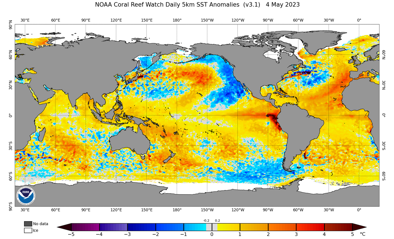
Looks like El Niño and possibly a strong one is imminent looking at the latest SST anomaly maps. Should be a lot of shear over the Caribbean and Gulf this hurricane season. Could see some big storms further out into the Central and East Atlantic though given the higher SST anomalies there and since those regions won’t be as impacted by the El Nino shear. Thinking Cape Verde and even Azores may have to watch.

Image
1 likes   

User avatar
SFLcane
S2K Supporter
S2K Supporter
Posts: 9617
Age: 46
Joined: Sat Jun 05, 2010 1:44 pm
Location: Lake Worth Florida

Re: 2023 Indicators (SST, SAL, MSLP, Wind shear, Steering, Instability) and Day 16+ Models

#319 Postby SFLcane » Fri May 05, 2023 8:58 pm

0 likes   

User avatar
chaser1
S2K Supporter
S2K Supporter
Posts: 4719
Age: 63
Joined: Sat Oct 15, 2005 5:59 pm
Location: Longwood, Fl

Re: 2023 Indicators (SST, SAL, MSLP, Wind shear, Steering, Instability) and Day 16+ Models

#320 Postby chaser1 » Fri May 05, 2023 11:18 pm

That's it, I've seen enough. The unusually positive AMO will prove to be the "gasoline", whereas El Nino might actually serve as an anticyclonic "flint" for northeast motion tropical development. What began early this year as mild curiosity, has rapidly transitioned into an outright fear and concern this season for everyone...........
East of 30W. Laugh now Iceland, but you may have just entered - the "warm zone" :layout:
2 likes   
Personal Forecast Disclaimer:
The posts in this forum are NOT official forecast and should not be used as such. They are just the opinion of the poster and may or may not be backed by sound meteorological data. They are NOT endorsed by any professional institution or storm2k.org. For official information, please refer to the NHC and NWS products.


Return to “Talkin' Tropics”

Who is online

Users browsing this forum: duilaslol, Pas_Bon and 34 guests